


Kevin Befus
@befushydro.bsky.social
Groundwater hydrologist with special research interests in coastal systems and sustainability.
Reposted by Kevin Befus

California #KingTides are coming soon!
We need your help to photograph the highest projected tides of the year, to create a record of changes to our shoreline while helping us understand what's vulnerable to flooding now and how sea level rise will impact California in the future. conta.cc/3Jb1S8Q
We need your help to photograph the highest projected tides of the year, to create a record of changes to our shoreline while helping us understand what's vulnerable to flooding now and how sea level rise will impact California in the future. conta.cc/3Jb1S8Q
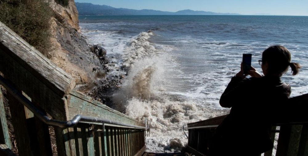
King Tides are coming soon
Email from California Coastal Commission We need your help to photograph king tides King Tides are Coming Soon! December 4th & 5th, 2025 and January 2nd & 3rd, 2026 Plus: Nov. 6th and Dec. 6th in Sout
conta.cc
October 31, 2025 at 6:14 PM
California #KingTides are coming soon!
We need your help to photograph the highest projected tides of the year, to create a record of changes to our shoreline while helping us understand what's vulnerable to flooding now and how sea level rise will impact California in the future. conta.cc/3Jb1S8Q
We need your help to photograph the highest projected tides of the year, to create a record of changes to our shoreline while helping us understand what's vulnerable to flooding now and how sea level rise will impact California in the future. conta.cc/3Jb1S8Q
Reposted by Kevin Befus

Summary of recent fieldwork in coastal NC - We ground truthed part of a massive new dataset of ghost forests along the US east coast. First paper of the project, led by Henry Yeung (UVA), should be out soon.
www.science.org/content/arti... #hydrology #remoteSensing #geosky
www.science.org/content/arti... #hydrology #remoteSensing #geosky

AI reveals vast ‘ghost forests’ along U.S. coast
Machine learning method counts nearly 12 million dead trees, many likely killed by rising seas
www.science.org
October 29, 2025 at 2:59 AM
Summary of recent fieldwork in coastal NC - We ground truthed part of a massive new dataset of ghost forests along the US east coast. First paper of the project, led by Henry Yeung (UVA), should be out soon.
www.science.org/content/arti... #hydrology #remoteSensing #geosky
www.science.org/content/arti... #hydrology #remoteSensing #geosky
Reposted by Kevin Befus

The Geology Dept at WWU is hiring an Assistant Prof in Hydrology! Come be my colleague in a great department! More info in the attached flyer, and at hr.wwu.edu/careers-facu...

October 13, 2025 at 7:20 PM
The Geology Dept at WWU is hiring an Assistant Prof in Hydrology! Come be my colleague in a great department! More info in the attached flyer, and at hr.wwu.edu/careers-facu...
Reposted by Kevin Befus

The past and future of water, primarily groundwater, and housing in the Phoenix metro. I learned some new things - including that it took 39 years (!) for Arizona's 1980 groundwater law to halt any growth. Thorough reporting from Tony Davis @highcountrynews.org www.hcn.org/issues/57-10...

The dried-out subdivisions of Phoenix - High Country News
A groundwater crisis halted the construction of thousands of homes and pitted affordability against environmental concerns.
www.hcn.org
October 6, 2025 at 7:52 PM
The past and future of water, primarily groundwater, and housing in the Phoenix metro. I learned some new things - including that it took 39 years (!) for Arizona's 1980 groundwater law to halt any growth. Thorough reporting from Tony Davis @highcountrynews.org www.hcn.org/issues/57-10...
Reposted by Kevin Befus
Hi King Tides Community! We need your help to photograph the upcoming King Tides. Your photos help us understand what's vulnerable to flooding today, plan for future sea level rise, and get us all talking and thinking about the impacts of the climate crisis. What can we do to make a difference?
(🧵)
(🧵)

October 6, 2025 at 4:57 PM
Hi King Tides Community! We need your help to photograph the upcoming King Tides. Your photos help us understand what's vulnerable to flooding today, plan for future sea level rise, and get us all talking and thinking about the impacts of the climate crisis. What can we do to make a difference?
(🧵)
(🧵)
Reposted by Kevin Befus
Excited to share our new review in Reviews of Geophysics! We explored the latest advances in tracer-aided mixing models for studying water in the Critical Zone. We synthesize new tracer methods, models, & key insights. I think it'll be a valuable resource for the community doi.org/10.1029/2024...

Recent Advances in Tracer‐Aided Mixing Modeling of Water in the Critical Zone
Tracer-aided mixing models are uniquely capable of identifying water flow paths and sources within the Critical Zone
Recent advances offer novel tracers and models for deeper and more accurate in...
doi.org
October 1, 2025 at 5:06 PM
Excited to share our new review in Reviews of Geophysics! We explored the latest advances in tracer-aided mixing models for studying water in the Critical Zone. We synthesize new tracer methods, models, & key insights. I think it'll be a valuable resource for the community doi.org/10.1029/2024...
Reposted by Kevin Befus

Here's a new long-term climate data viz site, climateradial.com, with a data upload option or based on info from meteostat.net. Temperature, precipitation, wind, and more depending on the site. Check it out and ask @climateradial.bsky.social for more sites!

September 30, 2025 at 3:24 PM
Here's a new long-term climate data viz site, climateradial.com, with a data upload option or based on info from meteostat.net. Temperature, precipitation, wind, and more depending on the site. Check it out and ask @climateradial.bsky.social for more sites!
Reposted by Kevin Befus

Currently *OBSESSED* by this tunnel-parallel cross-section along the Channel Tunnel between England and France 😍
#geoscience #geology ⚒️
Source: @geolsoc.bsky.social (www.geolsoc.org.uk/science-and-...)
#geoscience #geology ⚒️
Source: @geolsoc.bsky.social (www.geolsoc.org.uk/science-and-...)

September 22, 2025 at 2:53 PM
Currently *OBSESSED* by this tunnel-parallel cross-section along the Channel Tunnel between England and France 😍
#geoscience #geology ⚒️
Source: @geolsoc.bsky.social (www.geolsoc.org.uk/science-and-...)
#geoscience #geology ⚒️
Source: @geolsoc.bsky.social (www.geolsoc.org.uk/science-and-...)
Reposted by Kevin Befus
Groundwater news from day 2 at #IAH2025 in Naarm / Melbourne.
NGROS presentations by Wendy Timms and Akhi Kumar on groundwater recharge.
Find out more on NGROS at gi.copernicus.org/articles/13/...
Why not establish something similar in your country?
#groundwater
NGROS presentations by Wendy Timms and Akhi Kumar on groundwater recharge.
Find out more on NGROS at gi.copernicus.org/articles/13/...
Why not establish something similar in your country?
#groundwater

GI - An underground drip water monitoring network to characterize rainfall recharge of groundwater at different geologies, environments, and climates across Australia
Abstract. Understanding when and why groundwater recharge occurs is of fundamental importance for the sustainable use of this essential freshwater resource for humans and ecosystems. However, accurately capturing this component of the water balance is widely acknowledged to be a major challenge. Direct physical measurements identifying when groundwater recharge is occurring are possible by utilizing a sensor network of hydrological loggers deployed in underground spaces located in the vadose zone. Through measurements of water percolating into these spaces from above, we can record the potential groundwater recharge process in action. By using automated sensors, it is possible to precisely determine when recharge occurs (which event, month, or season and for which climate condition). Combined with daily rainfall data, it is possible to quantify the “rainfall recharge threshold”, the amount of rainfall needed to generate groundwater recharge, and its temporal and spatial variability. Australia's National Groundwater Recharge Observing System (NGROS) provides the first dedicated sensor network for observing groundwater recharge at an event scale across a wide range of geologies, environments, and climate types representing a wide range of Australian hydroclimates. Utilizing tunnels, mines, caves, and other subsurface spaces located in the vadose zone, the sensors effectively record “deep drainage”, water that can move beyond the shallow subsurface and root zone to generate groundwater recharge. The NGROS has the temporal resolution to capture individual recharge events, with multiple sensors deployed at each site to constrain the heterogeneity of recharge between different flow paths, and to quantify (including uncertainty bounds) rainfall recharge thresholds. Established in 2022, the network is described here together with examples of data being generated.
gi.copernicus.org
September 16, 2025 at 7:43 PM
Groundwater news from day 2 at #IAH2025 in Naarm / Melbourne.
NGROS presentations by Wendy Timms and Akhi Kumar on groundwater recharge.
Find out more on NGROS at gi.copernicus.org/articles/13/...
Why not establish something similar in your country?
#groundwater
NGROS presentations by Wendy Timms and Akhi Kumar on groundwater recharge.
Find out more on NGROS at gi.copernicus.org/articles/13/...
Why not establish something similar in your country?
#groundwater
Reposted by Kevin Befus
Once again a significant drought beginning to develop here in S. NE. Our new groundwater storage deficit analysis shows that 5 out of the last 9 yrs in a drought state. Interestingly switching from record wet to very dry (see 18, 21, 23) and to some extent last spring. @climatechris.bsky.social


September 2, 2025 at 5:14 PM
Once again a significant drought beginning to develop here in S. NE. Our new groundwater storage deficit analysis shows that 5 out of the last 9 yrs in a drought state. Interestingly switching from record wet to very dry (see 18, 21, 23) and to some extent last spring. @climatechris.bsky.social
What is an "Old Mine Cut" and how does it relate to more mainstream diamonds? Check out @kennethbefus.bsky.social on www.youtube.com/watch?v=JGCM... to learn more about the Kelce-Swift engagement diamond

Old Mine Cut - Celebrating a Kelce-Swift engagement
YouTube video by Kenneth Befus
www.youtube.com
August 27, 2025 at 2:42 PM
What is an "Old Mine Cut" and how does it relate to more mainstream diamonds? Check out @kennethbefus.bsky.social on www.youtube.com/watch?v=JGCM... to learn more about the Kelce-Swift engagement diamond
Reposted by Kevin Befus
Homo sapiens sapiens in Australia drinks groundwater that can be 2 Myo, stored when Homo habilis and Homo erectus still roamed the earth.
To keep this resource safe from overexploitation and contamination, recharge methods and rates have the predicted accurately.
phys.org/news/2025-08...
To keep this resource safe from overexploitation and contamination, recharge methods and rates have the predicted accurately.
phys.org/news/2025-08...

Groundwater: How scientists explore the mysteries of ancient aquifers
Beneath Australia's soils lie ancient aquifers which supply 30% of the water consumed across the country. The groundwater they hold can be some of the oldest water on the planet, dating back as far as...
phys.org
August 22, 2025 at 8:44 AM
Homo sapiens sapiens in Australia drinks groundwater that can be 2 Myo, stored when Homo habilis and Homo erectus still roamed the earth.
To keep this resource safe from overexploitation and contamination, recharge methods and rates have the predicted accurately.
phys.org/news/2025-08...
To keep this resource safe from overexploitation and contamination, recharge methods and rates have the predicted accurately.
phys.org/news/2025-08...
Reposted by Kevin Befus
Groundwater level monitoring at Salisbury Cathedral.
Salisbury Cathedral, built in the 13th century, is the highest is the UK reaching up to 123m and is built on wet sand and gravel close to the river Avon.
Salisbury Cathedral, built in the 13th century, is the highest is the UK reaching up to 123m and is built on wet sand and gravel close to the river Avon.

August 22, 2025 at 12:37 PM
Groundwater level monitoring at Salisbury Cathedral.
Salisbury Cathedral, built in the 13th century, is the highest is the UK reaching up to 123m and is built on wet sand and gravel close to the river Avon.
Salisbury Cathedral, built in the 13th century, is the highest is the UK reaching up to 123m and is built on wet sand and gravel close to the river Avon.
Reposted by Kevin Befus

"Models only matter if they track the world they describe. Here, the team tuned groundwater behavior against 57 wells across 34 sub-basins." 🌐🧪

Aquifer Economics at the Speed of Climate
On some High Plains nights, the wind drops to a hush and you can almost hear the aquifer below, a slow memory of Pleistocene storms moving through sand and silt.
open.substack.com
August 21, 2025 at 6:30 PM
"Models only matter if they track the world they describe. Here, the team tuned groundwater behavior against 57 wells across 34 sub-basins." 🌐🧪
Reposted by Kevin Befus
After firing hundreds of employees and a months-long hiring freeze, National Weather Service job postings have finally hit California. The weather service is hiring a hydrologist and and a supervisory hydrologist at the California-Nevada River Forecast Center in Sacramento. #CAwx
usajobs.gov
usajobs.gov

Hydrologist
This position is located in the River Forecast Center (RFC) with vacancies in each listed location. The RFCs keep watch over the nation's waterways to minimize loss of life and property damage from fl...
www.usajobs.gov
August 19, 2025 at 5:10 PM
After firing hundreds of employees and a months-long hiring freeze, National Weather Service job postings have finally hit California. The weather service is hiring a hydrologist and and a supervisory hydrologist at the California-Nevada River Forecast Center in Sacramento. #CAwx
usajobs.gov
usajobs.gov
Reposted by Kevin Befus

Interested in how river water changes under climate change + human perturbations?
Come join our diverse group of learners. You will learn and grow to ask questions, +use big data, reactive transport + machine learning models
"Somewhere, something incredible is waiting to be known." - Carl Sagan
Come join our diverse group of learners. You will learn and grow to ask questions, +use big data, reactive transport + machine learning models
"Somewhere, something incredible is waiting to be known." - Carl Sagan

August 13, 2025 at 8:34 PM
Interested in how river water changes under climate change + human perturbations?
Come join our diverse group of learners. You will learn and grow to ask questions, +use big data, reactive transport + machine learning models
"Somewhere, something incredible is waiting to be known." - Carl Sagan
Come join our diverse group of learners. You will learn and grow to ask questions, +use big data, reactive transport + machine learning models
"Somewhere, something incredible is waiting to be known." - Carl Sagan
Reposted by Kevin Befus

Excited to share this latest paper📃, reviewing and providing a searchable catalogue of >200 open access global datasets to study groundwater in social-ecological systems.
paper in ERL: tinyurl.com/55vtb8tb
The searchable catalogue is available thx to @igrac.bsky.social here: tinyurl.com/yjdtd5bx
paper in ERL: tinyurl.com/55vtb8tb
The searchable catalogue is available thx to @igrac.bsky.social here: tinyurl.com/yjdtd5bx

The Global Groundwater Data Catalogue: Your 'one-stop shop' to Groundwater Datasets - IGRAC
Global Groundwater Data Catalogue simplifies the process of identifying relevant datasets for interdisciplinary groundwater assessments.
un-igrac.org
August 6, 2025 at 9:06 PM
Excited to share this latest paper📃, reviewing and providing a searchable catalogue of >200 open access global datasets to study groundwater in social-ecological systems.
paper in ERL: tinyurl.com/55vtb8tb
The searchable catalogue is available thx to @igrac.bsky.social here: tinyurl.com/yjdtd5bx
paper in ERL: tinyurl.com/55vtb8tb
The searchable catalogue is available thx to @igrac.bsky.social here: tinyurl.com/yjdtd5bx
Reposted by Kevin Befus

Do you know about USGS's Groundwater Climate Response Network? It's a group of wells and springs specifically selected to monitor the effects of droughts and other climate variability on US groundwater systems. ⚒️
Overview:
doi.org/10.3133/gip254
View the network:
rconnect.usgs.gov/crn-map/CRNm...
Overview:
doi.org/10.3133/gip254
View the network:
rconnect.usgs.gov/crn-map/CRNm...

August 7, 2025 at 2:51 PM
Do you know about USGS's Groundwater Climate Response Network? It's a group of wells and springs specifically selected to monitor the effects of droughts and other climate variability on US groundwater systems. ⚒️
Overview:
doi.org/10.3133/gip254
View the network:
rconnect.usgs.gov/crn-map/CRNm...
Overview:
doi.org/10.3133/gip254
View the network:
rconnect.usgs.gov/crn-map/CRNm...
Reposted by Kevin Befus
Great 🧵 on groundwater/surface-water interactions. ⚒️🧪
Definitely watch the video, which is well done. It would also be great for teaching. It includes some great underwater video of groundwater discharging into the stream, where you can see the stream bed sediments being disturbed by the flow:
Definitely watch the video, which is well done. It would also be great for teaching. It includes some great underwater video of groundwater discharging into the stream, where you can see the stream bed sediments being disturbed by the flow:


August 7, 2025 at 8:02 AM
Great 🧵 on groundwater/surface-water interactions. ⚒️🧪
Definitely watch the video, which is well done. It would also be great for teaching. It includes some great underwater video of groundwater discharging into the stream, where you can see the stream bed sediments being disturbed by the flow:
Definitely watch the video, which is well done. It would also be great for teaching. It includes some great underwater video of groundwater discharging into the stream, where you can see the stream bed sediments being disturbed by the flow:
Reposted by Kevin Befus
New Nature Cities comment on how increasing groundwater salinity and levels pose threats to coastal urban infrastructure. Such processes should be included in the IPPC Special Report on Climate Change and Cities. Thanks to all coauthors rdcu.be/ezw0x

Invisible groundwater threats to coastal urban infrastructure
Nature Cities - Groundwater-associated hazards in coastal cities can be as acute as surface flood hazards, but are often overlooked, more persistent and harder to identify. Here we discuss how...
rdcu.be
August 6, 2025 at 3:11 PM
New Nature Cities comment on how increasing groundwater salinity and levels pose threats to coastal urban infrastructure. Such processes should be included in the IPPC Special Report on Climate Change and Cities. Thanks to all coauthors rdcu.be/ezw0x
Reposted by Kevin Befus

‘A hidden threat’: San Mateo lawmaker warns of rising groundwater risks, seeks study funding #cawater www.mercurynews.com/2025/07/29/b...
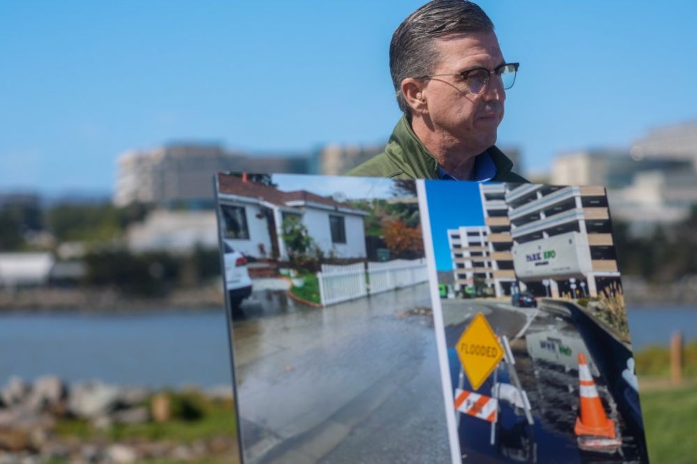
‘A hidden threat’: San Mateo lawmaker warns of rising groundwater risks, seeks study funding
Groundwater rise can mobilize toxic chemicals buried underground and increase the chance of chronic flooding.
www.mercurynews.com
July 30, 2025 at 4:39 PM
‘A hidden threat’: San Mateo lawmaker warns of rising groundwater risks, seeks study funding #cawater www.mercurynews.com/2025/07/29/b...
Reposted by Kevin Befus
Lawmakers Push to Map Groundwater Before It Swamps America’s Infrastructure #cawater www.kqed.org/science/1997...
Lawmakers Push to Map Groundwater Before It Swamps America’s Infrastructure | KQED
A Bay Area representative wants to map rising groundwater, a hidden climate threat for the region that could flood infrastructure and spread pollution.
www.kqed.org
July 30, 2025 at 4:39 PM
Lawmakers Push to Map Groundwater Before It Swamps America’s Infrastructure #cawater www.kqed.org/science/1997...
Reposted by Kevin Befus
This article is all about sea level and groundwater rise, without ever saying so.
Condos w/in a few miles of the ocean in Florida (and elsewhere) are more expensive to maintain as safe structures in part because saltwater is corroding their foundations. And no one wants to pay to fix foundations.
Condos w/in a few miles of the ocean in Florida (and elsewhere) are more expensive to maintain as safe structures in part because saltwater is corroding their foundations. And no one wants to pay to fix foundations.
July 30, 2025 at 12:05 PM
This article is all about sea level and groundwater rise, without ever saying so.
Condos w/in a few miles of the ocean in Florida (and elsewhere) are more expensive to maintain as safe structures in part because saltwater is corroding their foundations. And no one wants to pay to fix foundations.
Condos w/in a few miles of the ocean in Florida (and elsewhere) are more expensive to maintain as safe structures in part because saltwater is corroding their foundations. And no one wants to pay to fix foundations.
Reposted by Kevin Befus
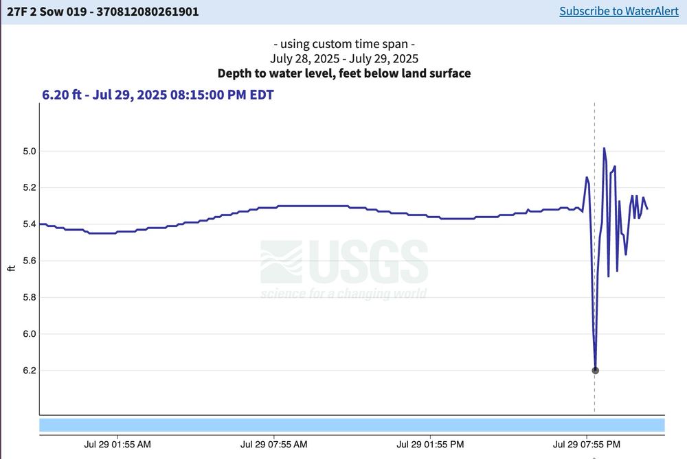
Look at that hydrograph! This is from a USGS monitoring well in Christiansburg, Montgomery County, VA. Observation well 27F2 SOW 019 is 450' deep, completed in carbonate rocks of the Elbrook Formation and well known for its response to quakes.
⚒️🧪
Data: waterdata.usgs.gov/monitoring-l...
⚒️🧪
Data: waterdata.usgs.gov/monitoring-l...
July 30, 2025 at 3:06 AM
Look at that hydrograph! This is from a USGS monitoring well in Christiansburg, Montgomery County, VA. Observation well 27F2 SOW 019 is 450' deep, completed in carbonate rocks of the Elbrook Formation and well known for its response to quakes.
⚒️🧪
Data: waterdata.usgs.gov/monitoring-l...
⚒️🧪
Data: waterdata.usgs.gov/monitoring-l...