


Hank Dolce
@hankdwx.bsky.social
LSU Coastal Meteorology Master’s student, B.S. Meteorology from Texas A&M.
Fan of baroclinicity and ball. Native Texan living in the bayou!
Fan of baroclinicity and ball. Native Texan living in the bayou!
Reposted by Hank Dolce

Given the primary chasers these days, every day is the most dangerous chasing day since El Reno 2013.
March 15, 2025 at 10:12 PM
Given the primary chasers these days, every day is the most dangerous chasing day since El Reno 2013.
Oklahoma fires seen via radar from OKC. Gale force surface winds combined with sub-20 dews and receptive fuels are to blame here. Everyone stay safe!
March 14, 2025 at 8:32 PM
Oklahoma fires seen via radar from OKC. Gale force surface winds combined with sub-20 dews and receptive fuels are to blame here. Everyone stay safe!
This is unacceptable. I know Cole personally. He is one of the most brilliant severe weather enthusiasts I know, more than deserving of a position at the National Weather Service. This needs to be fixed and fixed ASAP. These layoffs affect everyone regardless of your affiliation.

I just got fired from NWS . This email is all I know. Read if you want.
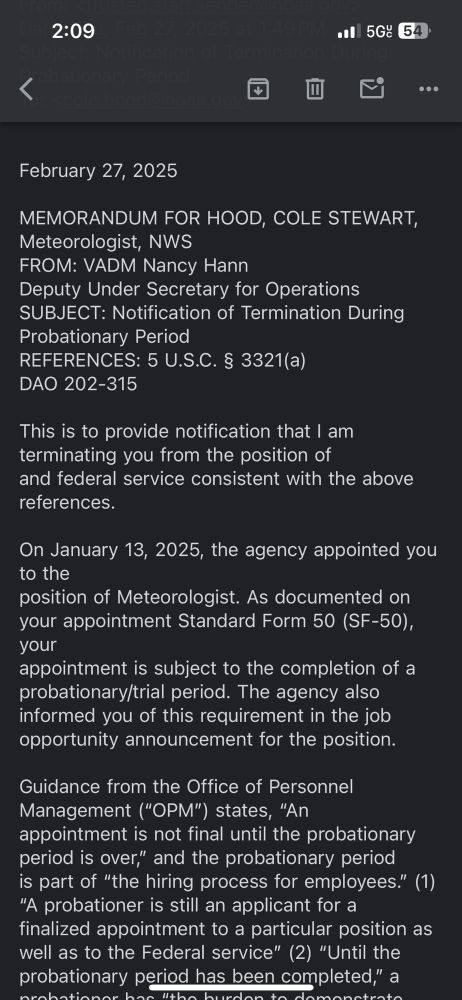
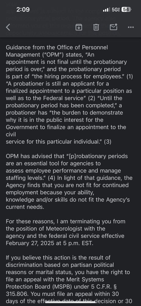
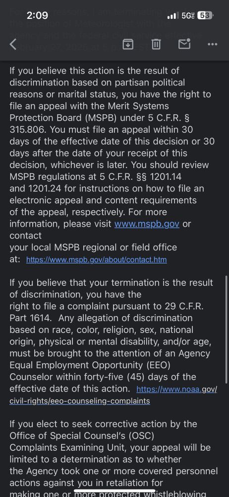
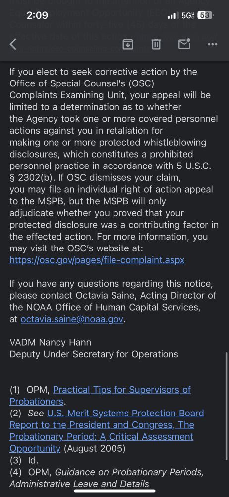
February 27, 2025 at 9:52 PM
This is unacceptable. I know Cole personally. He is one of the most brilliant severe weather enthusiasts I know, more than deserving of a position at the National Weather Service. This needs to be fixed and fixed ASAP. These layoffs affect everyone regardless of your affiliation.
Return flow overnight and this morning has been quite drastic. Latest METAR from KBTR had gale force wind gusts.
Moisture advection pretty stout and reaching a lot further north, helping to prime the atmosphere for another severe weather day shortly after a return to cooler weather here.
Moisture advection pretty stout and reaching a lot further north, helping to prime the atmosphere for another severe weather day shortly after a return to cooler weather here.


February 15, 2025 at 7:00 PM
Return flow overnight and this morning has been quite drastic. Latest METAR from KBTR had gale force wind gusts.
Moisture advection pretty stout and reaching a lot further north, helping to prime the atmosphere for another severe weather day shortly after a return to cooler weather here.
Moisture advection pretty stout and reaching a lot further north, helping to prime the atmosphere for another severe weather day shortly after a return to cooler weather here.
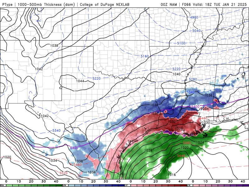
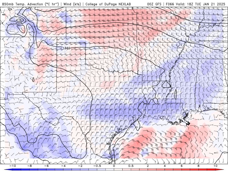
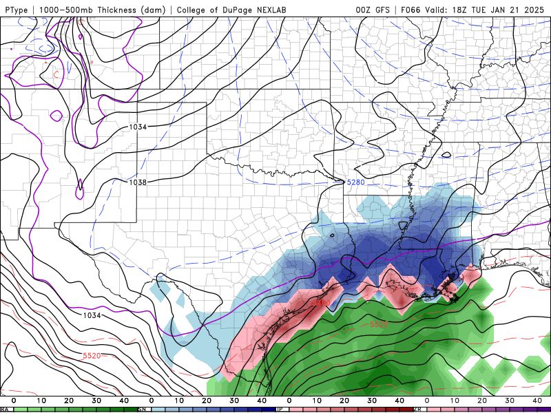
As opposed to other solutions from GFS/EURO, NAM has been consistent on 850mb WAA over south Louisiana on Tuesday, resulting in more FZRA/IP in the precip transition zone. NAM also has shown delayed cyclogenesis near Texas due to slower trough propagation. Worth monitoring. #lawx

January 19, 2025 at 4:02 AM
As opposed to other solutions from GFS/EURO, NAM has been consistent on 850mb WAA over south Louisiana on Tuesday, resulting in more FZRA/IP in the precip transition zone. NAM also has shown delayed cyclogenesis near Texas due to slower trough propagation. Worth monitoring. #lawx
For those searching for grad school options in meteorology, here’s one that may be off your radar:
The LSU coastal meteorology lab is always looking to recruit new students! You can DM me for additional questions or catch me at the #AMSStudent2025 grad school fair tomorrow!
The LSU coastal meteorology lab is always looking to recruit new students! You can DM me for additional questions or catch me at the #AMSStudent2025 grad school fair tomorrow!

January 10, 2025 at 4:36 PM
For those searching for grad school options in meteorology, here’s one that may be off your radar:
The LSU coastal meteorology lab is always looking to recruit new students! You can DM me for additional questions or catch me at the #AMSStudent2025 grad school fair tomorrow!
The LSU coastal meteorology lab is always looking to recruit new students! You can DM me for additional questions or catch me at the #AMSStudent2025 grad school fair tomorrow!
Reposted by Hank Dolce

this is legitimately a big deal. zillow now putting climate risk on their website.

December 29, 2024 at 10:33 PM
this is legitimately a big deal. zillow now putting climate risk on their website.
Reposted by Hank Dolce

Preliminary storm reports that followed... as of 7am ET Sunday:
Blue is wind damage.
Red is tornado.
Green is hail.
Blue is wind damage.
Red is tornado.
Green is hail.

December 29, 2024 at 12:37 PM
Preliminary storm reports that followed... as of 7am ET Sunday:
Blue is wind damage.
Red is tornado.
Green is hail.
Blue is wind damage.
Red is tornado.
Green is hail.
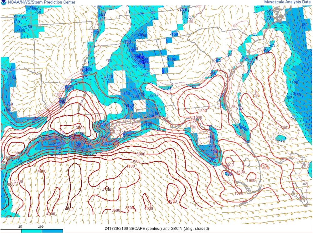
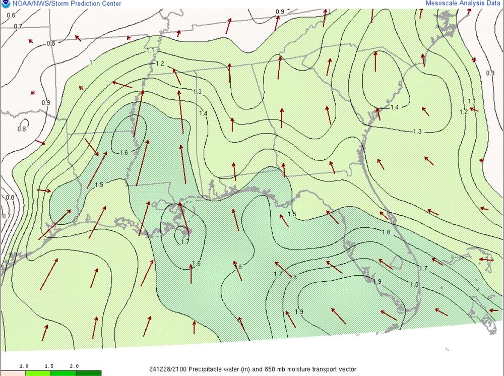
A lot of parameters are nearing the top end of climatology across Louisiana today. 3500 J/kg of SBCAPE, Td’s near 70, and PWATs of 1.5-1.6” are all near the 95th percentile or higher for late December. Add on significant LL veering and a potent shortwave and you have problems…


December 28, 2024 at 9:56 PM
A lot of parameters are nearing the top end of climatology across Louisiana today. 3500 J/kg of SBCAPE, Td’s near 70, and PWATs of 1.5-1.6” are all near the 95th percentile or higher for late December. Add on significant LL veering and a potent shortwave and you have problems…
Hope all my fellow Louisiana residents take this seriously…


December 28, 2024 at 9:23 PM
Hope all my fellow Louisiana residents take this seriously…
Reposted by Hank Dolce
30.78 inches makes Helene one of the most prolific rain events ever recorded from a TC in the interior US. The only other hurricane to drop comparable rain in Appalachia- Camille- killed 150+ in Nelson County, VA. Helene dropped such rain over a considerably larger area.

December 12, 2024 at 11:33 PM
30.78 inches makes Helene one of the most prolific rain events ever recorded from a TC in the interior US. The only other hurricane to drop comparable rain in Appalachia- Camille- killed 150+ in Nelson County, VA. Helene dropped such rain over a considerably larger area.
I’m presenting my Master’s research, which covers impacts of the SAL on tropical instability parameters and Puerto Rican rainfall, at AGU24 this afternoon from 1:40 to 5:30 at board 2118 in the poster hall. Hope to see y’all there!
December 12, 2024 at 2:12 PM
I’m presenting my Master’s research, which covers impacts of the SAL on tropical instability parameters and Puerto Rican rainfall, at AGU24 this afternoon from 1:40 to 5:30 at board 2118 in the poster hall. Hope to see y’all there!
The 2024 Atlantic Hurricane season is over. Here’s how it panned out, brought to you by The Chart™️.
Very busy season west of 80W, less so in the open Atlantic (aside from the region near 20N, 45W). Impressive to see 18 TCs given the lack of disturbances and unfavorable peak season background state.
Very busy season west of 80W, less so in the open Atlantic (aside from the region near 20N, 45W). Impressive to see 18 TCs given the lack of disturbances and unfavorable peak season background state.

December 2, 2024 at 12:00 AM
The 2024 Atlantic Hurricane season is over. Here’s how it panned out, brought to you by The Chart™️.
Very busy season west of 80W, less so in the open Atlantic (aside from the region near 20N, 45W). Impressive to see 18 TCs given the lack of disturbances and unfavorable peak season background state.
Very busy season west of 80W, less so in the open Atlantic (aside from the region near 20N, 45W). Impressive to see 18 TCs given the lack of disturbances and unfavorable peak season background state.
Reposted by Hank Dolce

"Reflections on the 2024 Atlantic Hurricane Season" | My latest on the michaelmann blog: michaelmann.net/content/refl...

Reflections on the 2024 Atlantic Hurricane Season
Now that the 2024 Atlantic hurricane season seems to be coming to a close, it is worth reflecting on what transpired and what we might learn from it. By most measures, it was an active, destructive an...
michaelmann.net
November 27, 2024 at 3:28 PM
"Reflections on the 2024 Atlantic Hurricane Season" | My latest on the michaelmann blog: michaelmann.net/content/refl...
Reposted by Hank Dolce

Bomb cyclone goes boom.
An incredible view of the deepening low pressure system approaching the Pacific Northwest.
An incredible view of the deepening low pressure system approaching the Pacific Northwest.
November 20, 2024 at 1:53 AM
Bomb cyclone goes boom.
An incredible view of the deepening low pressure system approaching the Pacific Northwest.
An incredible view of the deepening low pressure system approaching the Pacific Northwest.
Post a picture you took (no description) to bring some zen to the timeline.

November 16, 2024 at 11:44 PM
Post a picture you took (no description) to bring some zen to the timeline.
Decided to make the jump here haha. Will still be using my twitter but this is going to be more for meteorology-related things.
November 14, 2024 at 3:53 AM
Decided to make the jump here haha. Will still be using my twitter but this is going to be more for meteorology-related things.