


Baptiste Gombert
@baptistegomb.bsky.social
Satellite Hydrology Specialist at CNES🛰️, but also with strong interests in seismology, tectonics, geophysics... and mountaineering!
Pinned

Superb observation by the SWOT altimetry satellite of the July 30 #tsunami. Data acquired ~1h after the M8.8 Kamchatka earthquake show the waves propagating across the Pacific with a great agreement with @rocangel.bsky.social's model!
[more here](www.aviso.altimetry.fr/fr/missions/...)
#CNES #CLS
[more here](www.aviso.altimetry.fr/fr/missions/...)
#CNES #CLS
Reposted by Baptiste Gombert

Magnitude 6 #earthquake near Jalalabad in E #Afghanistan, close to the border with Pakistan.
Mechanism is thrust on a shallow SE or NW dipping fault.
General context is the India-Asia collision which placed the region under a N-S shortening. ⚒️
Mechanism is thrust on a shallow SE or NW dipping fault.
General context is the India-Asia collision which placed the region under a N-S shortening. ⚒️

Mw=6.0, SOUTHEASTERN AFGHANISTAN (Depth: 8 km), 2025/08/31 19:17:34 UTC - Full details here: http://geoscope.ipgp.fr/scripts/seismes/fiche.php?seis=us7000qsvj

September 1, 2025 at 6:03 AM
Magnitude 6 #earthquake near Jalalabad in E #Afghanistan, close to the border with Pakistan.
Mechanism is thrust on a shallow SE or NW dipping fault.
General context is the India-Asia collision which placed the region under a N-S shortening. ⚒️
Mechanism is thrust on a shallow SE or NW dipping fault.
General context is the India-Asia collision which placed the region under a N-S shortening. ⚒️
Reposted by Baptiste Gombert

We are entering a new era for tsunami observations and model validation-- The SWOT era! Thanks a lot @baptistegomb.bsky.social for reaching out, this was a fun collaboration. Also great working with @diegosismologo.bsky.social and @valah.bsky.social. @haskoliislands.bsky.social
Superb observation by the SWOT altimetry satellite of the July 30 #tsunami. Data acquired ~1h after the M8.8 Kamchatka earthquake show the waves propagating across the Pacific with a great agreement with @rocangel.bsky.social's model!
[more here](www.aviso.altimetry.fr/fr/missions/...)
#CNES #CLS
[more here](www.aviso.altimetry.fr/fr/missions/...)
#CNES #CLS
August 11, 2025 at 1:18 PM
We are entering a new era for tsunami observations and model validation-- The SWOT era! Thanks a lot @baptistegomb.bsky.social for reaching out, this was a fun collaboration. Also great working with @diegosismologo.bsky.social and @valah.bsky.social. @haskoliislands.bsky.social
Superb observation by the SWOT altimetry satellite of the July 30 #tsunami. Data acquired ~1h after the M8.8 Kamchatka earthquake show the waves propagating across the Pacific with a great agreement with @rocangel.bsky.social's model!
[more here](www.aviso.altimetry.fr/fr/missions/...)
#CNES #CLS
[more here](www.aviso.altimetry.fr/fr/missions/...)
#CNES #CLS
August 11, 2025 at 9:52 AM
Superb observation by the SWOT altimetry satellite of the July 30 #tsunami. Data acquired ~1h after the M8.8 Kamchatka earthquake show the waves propagating across the Pacific with a great agreement with @rocangel.bsky.social's model!
[more here](www.aviso.altimetry.fr/fr/missions/...)
#CNES #CLS
[more here](www.aviso.altimetry.fr/fr/missions/...)
#CNES #CLS
Reposted by Baptiste Gombert
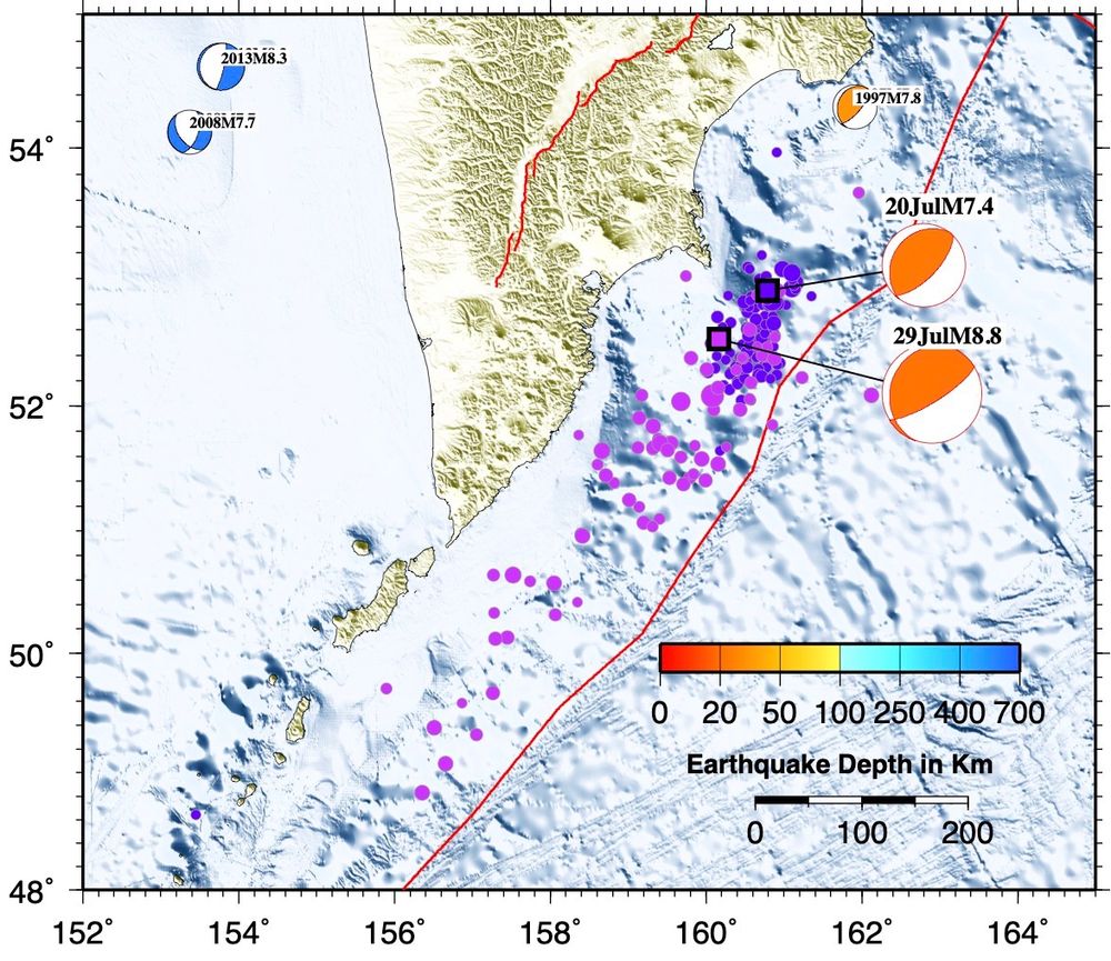
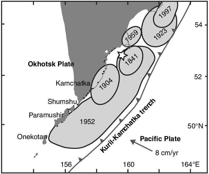
The aftershock zone of today’s M8.8 Kamchatka megathrust #earthquake is comparable to the rupture area of the 1952 rupture zone from Macinnes et al. (2010). At a rate of 8 cm/year, the accumulated slip of 6 m since 1952 matches with the preliminary rupture model of today’s earthquake pretty well. 🧪⚒️
July 30, 2025 at 10:57 AM
The aftershock zone of today’s M8.8 Kamchatka megathrust #earthquake is comparable to the rupture area of the 1952 rupture zone from Macinnes et al. (2010). At a rate of 8 cm/year, the accumulated slip of 6 m since 1952 matches with the preliminary rupture model of today’s earthquake pretty well. 🧪⚒️
Reposted by Baptiste Gombert

⚒️ 🧪
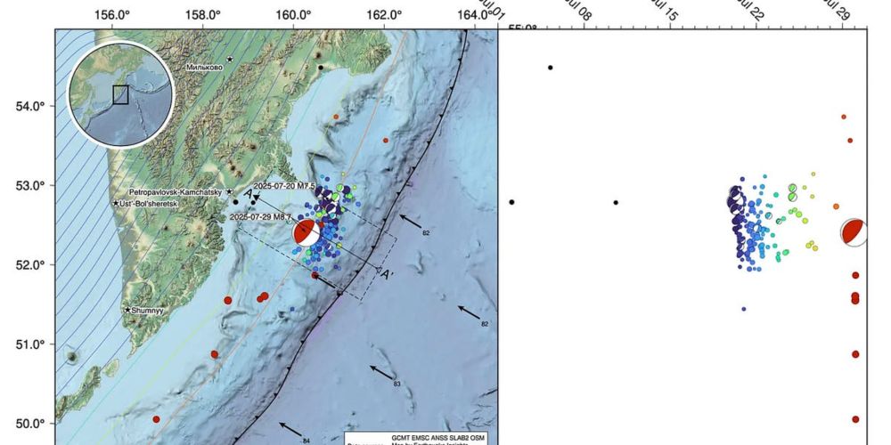
A M8.8 earthquake just ruptured the subduction zone offshore Russia’s Kamchatka peninsula. This is one of the world’s truly huge earthquakes, and a triggered tsunami is currently traveling across the Pacific ocean.
This same fault ruptured on July 20th in a M7.4, and last August in a M7.1.
A M8.8 earthquake just ruptured the subduction zone offshore Russia’s Kamchatka peninsula. This is one of the world’s truly huge earthquakes, and a triggered tsunami is currently traveling across the Pacific ocean.
This same fault ruptured on July 20th in a M7.4, and last August in a M7.1.
M8.8 earthquake strikes offshore Kamchatka
A dangerous subduction megathrust ruptures once again
earthquakeinsights.substack.com
July 30, 2025 at 4:05 AM
⚒️ 🧪
A M8.8 earthquake just ruptured the subduction zone offshore Russia’s Kamchatka peninsula. This is one of the world’s truly huge earthquakes, and a triggered tsunami is currently traveling across the Pacific ocean.
This same fault ruptured on July 20th in a M7.4, and last August in a M7.1.
A M8.8 earthquake just ruptured the subduction zone offshore Russia’s Kamchatka peninsula. This is one of the world’s truly huge earthquakes, and a triggered tsunami is currently traveling across the Pacific ocean.
This same fault ruptured on July 20th in a M7.4, and last August in a M7.1.
Reposted by Baptiste Gombert

Simulated propagation of tsunami generated by Kamchatka M8.8 earthquake. Generated by NCDR, Taiwan. 🧪⚒️⚛️
July 30, 2025 at 5:09 AM
Simulated propagation of tsunami generated by Kamchatka M8.8 earthquake. Generated by NCDR, Taiwan. 🧪⚒️⚛️
Reposted by Baptiste Gombert

Canicule intense dès juin, mais c’est l’écologie qui est punitive. Il est urgent… de détricoter les mesures environnementales.
Les sdf, les pauvres, les malades, les retraités, les enfants, les agriculteurs, les ouvriers, victimes de la chaleur, comptent donc si peu pour nos parlementaires?
🤢🤢🤢
Les sdf, les pauvres, les malades, les retraités, les enfants, les agriculteurs, les ouvriers, victimes de la chaleur, comptent donc si peu pour nos parlementaires?
🤢🤢🤢

🌡️ Vague de chaleur à surveiller à partir de jeudi: la température va monter progressivement. Préservez dès maintenant le frais dans vos logements !
Apprenez les bons gestes:
Apprenez les bons gestes:


June 18, 2025 at 6:02 AM
Canicule intense dès juin, mais c’est l’écologie qui est punitive. Il est urgent… de détricoter les mesures environnementales.
Les sdf, les pauvres, les malades, les retraités, les enfants, les agriculteurs, les ouvriers, victimes de la chaleur, comptent donc si peu pour nos parlementaires?
🤢🤢🤢
Les sdf, les pauvres, les malades, les retraités, les enfants, les agriculteurs, les ouvriers, victimes de la chaleur, comptent donc si peu pour nos parlementaires?
🤢🤢🤢
Reposted by Baptiste Gombert

Delighted to see our @NERCscience @EvoFlood project research on changing flood hazard and risk profiled by @theAGU 💜 @lborouniversity
eos.org/research-spo...
eos.org/research-spo...
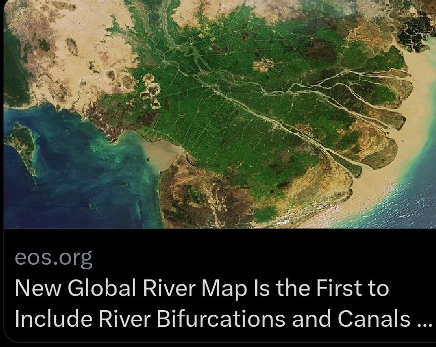
May 16, 2025 at 12:00 AM
Delighted to see our @NERCscience @EvoFlood project research on changing flood hazard and risk profiled by @theAGU 💜 @lborouniversity
eos.org/research-spo...
eos.org/research-spo...
Reposted by Baptiste Gombert

Apparently surface rupture during the Myanmar 2025. I'm very surprised by the weak shaking along the rupture. I'm not sure if this is the main rupture (I would say no - nonetheless, VERY COOL). Author unknown, location Thazi (to be confirmed)
May 12, 2025 at 2:18 AM
Apparently surface rupture during the Myanmar 2025. I'm very surprised by the weak shaking along the rupture. I'm not sure if this is the main rupture (I would say no - nonetheless, VERY COOL). Author unknown, location Thazi (to be confirmed)
Our paper on the speckle noise spectrum of the SWIM instrument aboard the CFOSAT oceanography satellite is online on IEEE TGRS!
ieeexplore.ieee.org/document/109...
ieeexplore.ieee.org/document/109...

April 29, 2025 at 8:04 AM
Our paper on the speckle noise spectrum of the SWIM instrument aboard the CFOSAT oceanography satellite is online on IEEE TGRS!
ieeexplore.ieee.org/document/109...
ieeexplore.ieee.org/document/109...
Reposted by Baptiste Gombert

Sentinel-2 reveals the surface deformation after the 2025 #Myanmar #earthquake www.cesbio.cnrs.fr/multitemp/se...
April 2, 2025 at 9:04 PM
Sentinel-2 reveals the surface deformation after the 2025 #Myanmar #earthquake www.cesbio.cnrs.fr/multitemp/se...
Reposted by Baptiste Gombert
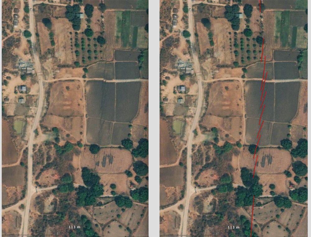
High resolution MAXAR satellite image reveals the #Myanmar #earthquake surface rupture north of the town of Sagaing. It is close to epicenter and N tip of the >400km long rupture.
Right-lateral offset of ~3.2m is clearly illustrated by the distorsion and lateral shift of a dirt road striking E-W.
Right-lateral offset of ~3.2m is clearly illustrated by the distorsion and lateral shift of a dirt road striking E-W.
April 2, 2025 at 8:07 AM
High resolution MAXAR satellite image reveals the #Myanmar #earthquake surface rupture north of the town of Sagaing. It is close to epicenter and N tip of the >400km long rupture.
Right-lateral offset of ~3.2m is clearly illustrated by the distorsion and lateral shift of a dirt road striking E-W.
Right-lateral offset of ~3.2m is clearly illustrated by the distorsion and lateral shift of a dirt road striking E-W.
Reposted by Baptiste Gombert

Updated processing from Sentinel-1 data over the #MyanmarEarthquake. Here are azimuth and range offsets, displacements in the indicated lines-of-sight (LOS). The azimuth offsets' LOS is better aligned with the fault strike, hence its larger displacement. Rupture extends ~400 km south of Mandalay.


April 2, 2025 at 10:55 AM
Updated processing from Sentinel-1 data over the #MyanmarEarthquake. Here are azimuth and range offsets, displacements in the indicated lines-of-sight (LOS). The azimuth offsets' LOS is better aligned with the fault strike, hence its larger displacement. Rupture extends ~400 km south of Mandalay.
Reposted by Baptiste Gombert

Remote surface rupture observations for the M7.7 2025 Myanmar earthquake - soft rollout!
doi.org/10.5066/P1RY...
Simple fault trace and slip distribution from pixel tracking, high-res from available imagery. Watch for updates!
⚒️ USGS and collaborators effort led by @nadinegrr.bsky.social 🙏
doi.org/10.5066/P1RY...
Simple fault trace and slip distribution from pixel tracking, high-res from available imagery. Watch for updates!
⚒️ USGS and collaborators effort led by @nadinegrr.bsky.social 🙏

April 1, 2025 at 10:46 PM
Remote surface rupture observations for the M7.7 2025 Myanmar earthquake - soft rollout!
doi.org/10.5066/P1RY...
Simple fault trace and slip distribution from pixel tracking, high-res from available imagery. Watch for updates!
⚒️ USGS and collaborators effort led by @nadinegrr.bsky.social 🙏
doi.org/10.5066/P1RY...
Simple fault trace and slip distribution from pixel tracking, high-res from available imagery. Watch for updates!
⚒️ USGS and collaborators effort led by @nadinegrr.bsky.social 🙏
Reposted by Baptiste Gombert

Update: Preliminary coseismic displacements of 2025 Myanmar earthquake from @CopernicusEU @ESA #Sentinel2 images by using #CosiCorr, processed by @NTU_TW GEOG
#Copernicus
1. Rupture propagated from N to S
2. Max. offset >4m
3. Rupture length ~500km
#Copernicus
1. Rupture propagated from N to S
2. Max. offset >4m
3. Rupture length ~500km

April 1, 2025 at 12:56 PM
Update: Preliminary coseismic displacements of 2025 Myanmar earthquake from @CopernicusEU @ESA #Sentinel2 images by using #CosiCorr, processed by @NTU_TW GEOG
#Copernicus
1. Rupture propagated from N to S
2. Max. offset >4m
3. Rupture length ~500km
#Copernicus
1. Rupture propagated from N to S
2. Max. offset >4m
3. Rupture length ~500km
Reposted by Baptiste Gombert

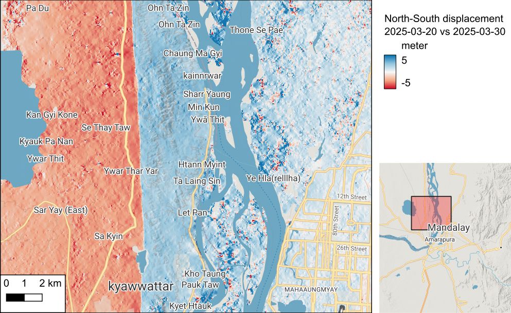
The descending interferogram from Sentinel-1 (20250319-20250331) suggests that the earthquake rupture extends to 18.7 degrees and may have reached further south. More data in the next few days will reveal the full length of the rupture from this devastating earthquake.
April 1, 2025 at 11:05 AM
The descending interferogram from Sentinel-1 (20250319-20250331) suggests that the earthquake rupture extends to 18.7 degrees and may have reached further south. More data in the next few days will reveal the full length of the rupture from this devastating earthquake.
Reposted by Baptiste Gombert
🧪⚒️
Two days after the M7.7 earthquake in Myanmar, what have we learned?
Rapid seismological analyses shared by scientists suggest that the rupture was both longer and faster than expected - two factors that could have increased damage.
Read more: earthquakeinsights.substack.com/p/updates-on...
Two days after the M7.7 earthquake in Myanmar, what have we learned?
Rapid seismological analyses shared by scientists suggest that the rupture was both longer and faster than expected - two factors that could have increased damage.
Read more: earthquakeinsights.substack.com/p/updates-on...

Updates on the M7.7 Myanmar earthquake
An unusually long, possibly supershear rupture
earthquakeinsights.substack.com
March 30, 2025 at 7:43 PM
🧪⚒️
Two days after the M7.7 earthquake in Myanmar, what have we learned?
Rapid seismological analyses shared by scientists suggest that the rupture was both longer and faster than expected - two factors that could have increased damage.
Read more: earthquakeinsights.substack.com/p/updates-on...
Two days after the M7.7 earthquake in Myanmar, what have we learned?
Rapid seismological analyses shared by scientists suggest that the rupture was both longer and faster than expected - two factors that could have increased damage.
Read more: earthquakeinsights.substack.com/p/updates-on...
Reposted by Baptiste Gombert
The latest models from the USGS show slip, and associated strong shaking, extending much further to the south. Here I have plotted contours of estimated shaking over a map of population density. Note that the fault runs south through a narrow valley that is densely populated.
⚒️ 🧪 Myanmar earthquake
⚒️ 🧪 Myanmar earthquake

March 29, 2025 at 2:09 PM
The latest models from the USGS show slip, and associated strong shaking, extending much further to the south. Here I have plotted contours of estimated shaking over a map of population density. Note that the fault runs south through a narrow valley that is densely populated.
⚒️ 🧪 Myanmar earthquake
⚒️ 🧪 Myanmar earthquake
Reposted by Baptiste Gombert
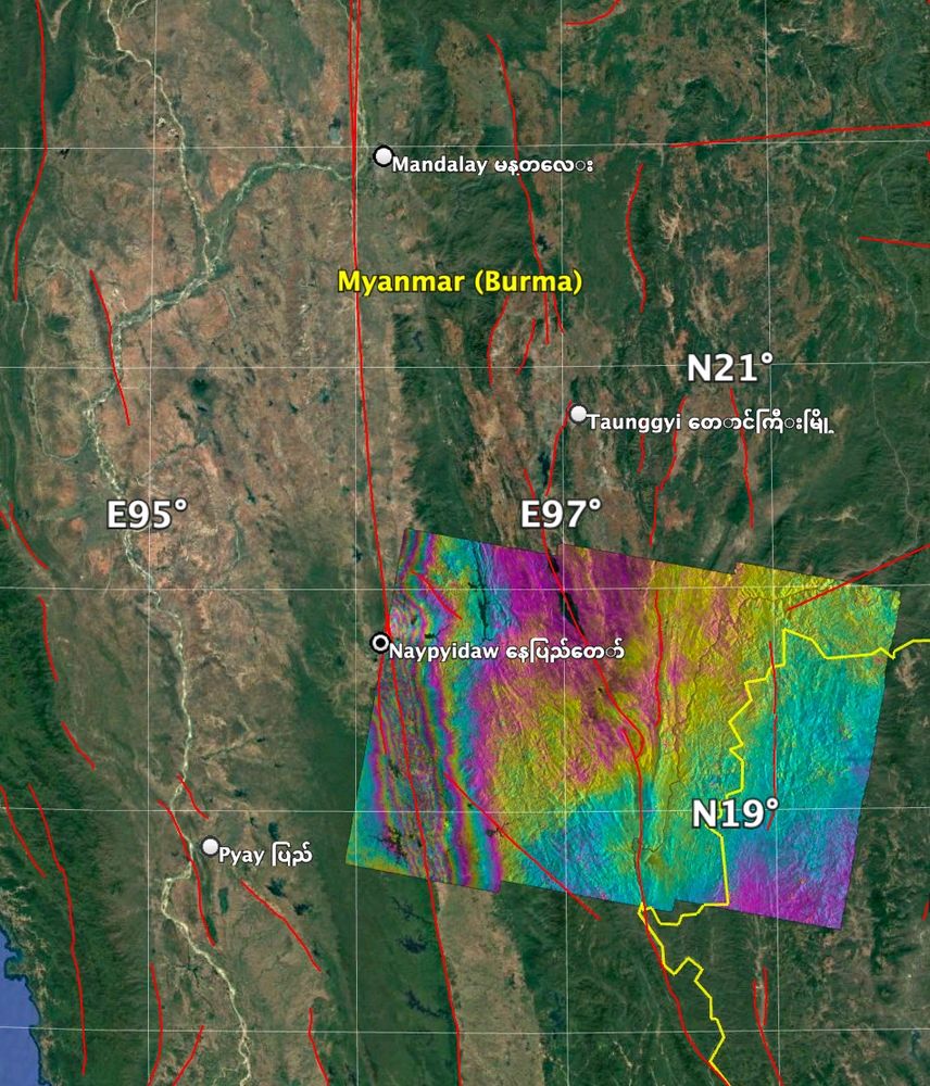
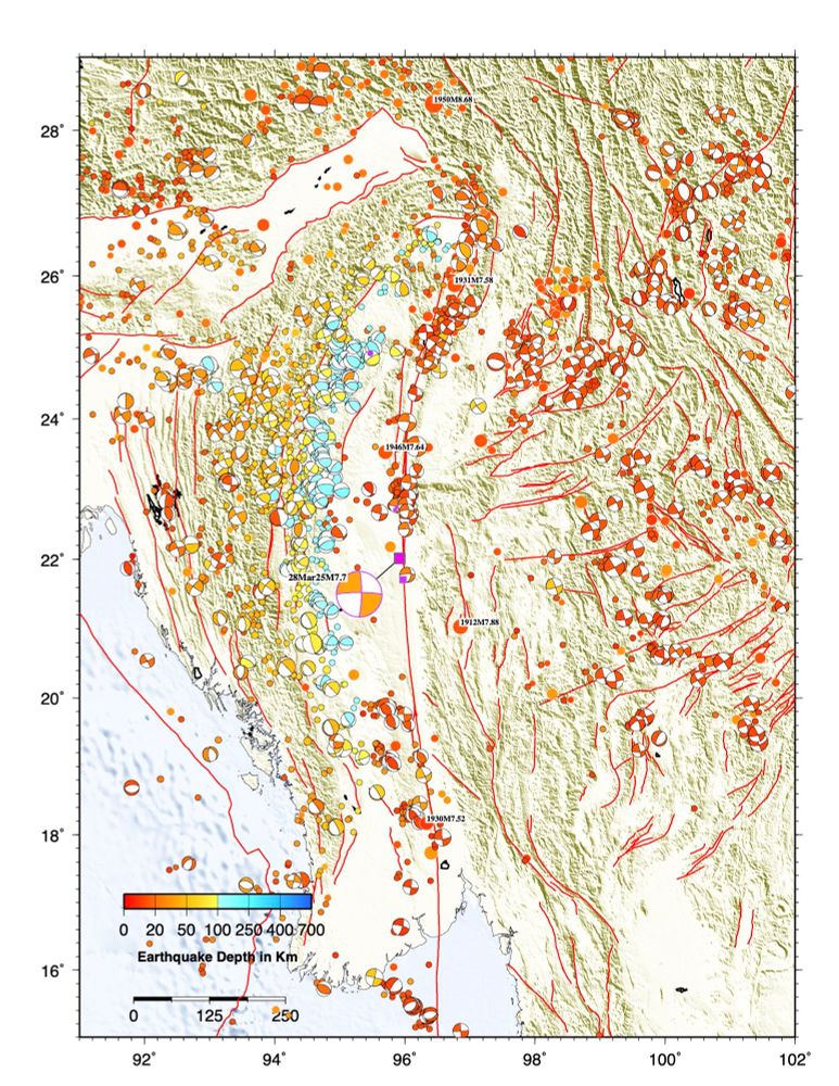
A historical seismicity map shows several #earthquakes of similar size to today’s M7.7 in Myanmar occurred in the region in the early 20th century, but this section of the Sagaing fault probably hasn’t ruptured since 1839 🧪⚒️
March 28, 2025 at 9:16 AM
A historical seismicity map shows several #earthquakes of similar size to today’s M7.7 in Myanmar occurred in the region in the early 20th century, but this section of the Sagaing fault probably hasn’t ruptured since 1839 🧪⚒️
Reposted by Baptiste Gombert

The revised focal mechanism is RLSS. Wikipedia has a nice map with the fault sections on it and Ray thinks that is was the section that hasn’t ruptured since 1839.

March 28, 2025 at 7:33 AM
The revised focal mechanism is RLSS. Wikipedia has a nice map with the fault sections on it and Ray thinks that is was the section that hasn’t ruptured since 1839.
Reposted by Baptiste Gombert
Surface waves are still rolling through on my broadband in NZ:

March 28, 2025 at 8:06 AM
Surface waves are still rolling through on my broadband in NZ:
Reposted by Baptiste Gombert

First slip map for the Mw 7.8 Myanmar earthquake. Propagation of rupture towards the South. Slipnear method (Géoazur/OCA).

March 28, 2025 at 8:17 AM
First slip map for the Mw 7.8 Myanmar earthquake. Propagation of rupture towards the South. Slipnear method (Géoazur/OCA).
Reposted by Baptiste Gombert
I made a quick map of historical seismicity for the region of today’s M7.6 #earthquake near the Cayman Islands. This left lateral strike slip event occurred on a fault system that produced a few similar events in size & mechanism in the last decade.
(Good to see that USGS NEIC is still online!)🧪⚒️
(Good to see that USGS NEIC is still online!)🧪⚒️

February 9, 2025 at 8:31 AM
I made a quick map of historical seismicity for the region of today’s M7.6 #earthquake near the Cayman Islands. This left lateral strike slip event occurred on a fault system that produced a few similar events in size & mechanism in the last decade.
(Good to see that USGS NEIC is still online!)🧪⚒️
(Good to see that USGS NEIC is still online!)🧪⚒️
Some beauty for the eyes

Castle Mountain Fault scarp cutting across the Little Susitna River about 50km north of Anchorage, #Alaska. #lidar #geomorphology #faultscarp
January 20, 2025 at 8:21 AM
Some beauty for the eyes
Reposted by Baptiste Gombert

Launch update: #nisar, a powerful Earth-observing satellite, is targeting a likely launch date in March 2025.
The joint @nasa-@IsrO mission will scan nearly all of Earth’s land and ice surfaces to measure changes down to fractions of an inch: https://blogs.nasa.gov/nisar
The joint @nasa-@IsrO mission will scan nearly all of Earth’s land and ice surfaces to measure changes down to fractions of an inch: https://blogs.nasa.gov/nisar
NASA, ISRO Aiming to Launch NISAR Mission in March 2025
<p>NASA and the Indian Space Research Organisation (ISRO) are looking at a likely launch date in March 2025 for the NISAR satellite. Short for NASA-ISRO Synthetic Aperture Radar, NISAR will scan nearly all of Earth’s land and ice surfaces twice every 12 days to measure changes in the planet’s ecosystems, its land and sea ice, and its solid Earth. The NISAR satellite will launch from Satish Dhawan Space Centre on India’s southeastern coast.</p>
<p><strong>News Media Contact<br/>
</strong>Andrew Wang<br/>
Jet Propulsion Laboratory, Pasadena, Calif.<br/>
626-379-6874<br/>
<a href="mailto:andrew.wang@jpl.nasa.gov">andrew.wang@jpl.nasa.gov</a></p>
blogs.nasa.gov
December 21, 2024 at 12:40 AM
Launch update: #nisar, a powerful Earth-observing satellite, is targeting a likely launch date in March 2025.
The joint @nasa-@IsrO mission will scan nearly all of Earth’s land and ice surfaces to measure changes down to fractions of an inch: https://blogs.nasa.gov/nisar
The joint @nasa-@IsrO mission will scan nearly all of Earth’s land and ice surfaces to measure changes down to fractions of an inch: https://blogs.nasa.gov/nisar