


Yann Cabon
@yanncabon.bsky.social
Dev Lead 🌍 ArcGIS Maps SDK for JavaScript 🗺️
Reposted by Yann Cabon

ECMAScript excitement 😉
Congrats to @manishearth.bsky.social on unflagging TC39 Stage 3 Temporal in V8 today. Heading for Chrome 144 🎉
By many metrics this new date-time API is the single biggest change to JS ever 🔥
V8 uses Boa's temporal_rs by @jason-williams.co.uk Kevin Ness & Manish 👍
Congrats to @manishearth.bsky.social on unflagging TC39 Stage 3 Temporal in V8 today. Heading for Chrome 144 🎉
By many metrics this new date-time API is the single biggest change to JS ever 🔥
V8 uses Boa's temporal_rs by @jason-williams.co.uk Kevin Ness & Manish 👍
November 4, 2025 at 7:49 PM
ECMAScript excitement 😉
Congrats to @manishearth.bsky.social on unflagging TC39 Stage 3 Temporal in V8 today. Heading for Chrome 144 🎉
By many metrics this new date-time API is the single biggest change to JS ever 🔥
V8 uses Boa's temporal_rs by @jason-williams.co.uk Kevin Ness & Manish 👍
Congrats to @manishearth.bsky.social on unflagging TC39 Stage 3 Temporal in V8 today. Heading for Chrome 144 🎉
By many metrics this new date-time API is the single biggest change to JS ever 🔥
V8 uses Boa's temporal_rs by @jason-williams.co.uk Kevin Ness & Manish 👍
Reposted by Yann Cabon

✍️ New Article: Use Cases for Field Sizing
A quick look at field-sizing and where it can be used. I hope this will land in Firefox and Safari soon. The good thing? We can use it as an enhancement.
🔗 ishadeed.com/article/fiel...
A quick look at field-sizing and where it can be used. I hope this will land in Firefox and Safari soon. The good thing? We can use it as an enhancement.
🔗 ishadeed.com/article/fiel...
November 1, 2025 at 6:27 AM
✍️ New Article: Use Cases for Field Sizing
A quick look at field-sizing and where it can be used. I hope this will land in Firefox and Safari soon. The good thing? We can use it as an enhancement.
🔗 ishadeed.com/article/fiel...
A quick look at field-sizing and where it can be used. I hope this will land in Firefox and Safari soon. The good thing? We can use it as an enhancement.
🔗 ishadeed.com/article/fiel...
Reposted by Yann Cabon

I'll never get why Kenna wasn't huge. Entire new sacred cow album >


August 14, 2025 at 2:08 PM
I'll never get why Kenna wasn't huge. Entire new sacred cow album >
Reposted by Yann Cabon
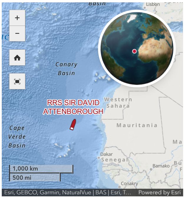
Did you know that it's possible to follow the RRS Sir David Attenborough on @bas.ac.uk's website? We provide the maps and location tracking to underpin this. 🚢🗺️
See the latest position of the ship here, on its way north after a long season in Antarctica! www.bas.ac.uk/polar-operat...
See the latest position of the ship here, on its way north after a long season in Antarctica! www.bas.ac.uk/polar-operat...
July 9, 2025 at 4:30 PM
Did you know that it's possible to follow the RRS Sir David Attenborough on @bas.ac.uk's website? We provide the maps and location tracking to underpin this. 🚢🗺️
See the latest position of the ship here, on its way north after a long season in Antarctica! www.bas.ac.uk/polar-operat...
See the latest position of the ship here, on its way north after a long season in Antarctica! www.bas.ac.uk/polar-operat...
Reposted by Yann Cabon
ECMAScript excitement 😉
Firefox 139 ships the TC39 Stage 3 Temporal proposal 🎉
It's about time.
Congrats to those who worked on the implementation including Andre Bargull & Dan Minor 👍
developer.mozilla.org/en-US/docs/M...
Firefox 139 ships the TC39 Stage 3 Temporal proposal 🎉
It's about time.
Congrats to those who worked on the implementation including Andre Bargull & Dan Minor 👍
developer.mozilla.org/en-US/docs/M...

Firefox 139 for developers - Mozilla | MDN
This article provides information about the changes in Firefox 139 that affect developers. Firefox 139 is the current Beta version of Firefox and ships on May 27, 2025.
developer.mozilla.org
May 28, 2025 at 6:03 AM
ECMAScript excitement 😉
Firefox 139 ships the TC39 Stage 3 Temporal proposal 🎉
It's about time.
Congrats to those who worked on the implementation including Andre Bargull & Dan Minor 👍
developer.mozilla.org/en-US/docs/M...
Firefox 139 ships the TC39 Stage 3 Temporal proposal 🎉
It's about time.
Congrats to those who worked on the implementation including Andre Bargull & Dan Minor 👍
developer.mozilla.org/en-US/docs/M...
Reposted by Yann Cabon

I've experimented with some of the new (*beta) ArcGIS Geometry Operators! Here I am using the minimumBoundingCircleOperator to help generate the preview graphic for measurement Polylines drawn on the map. Steal the code here: gist.github.com/JonnyDawe/76... #ArcGIS
November 25, 2024 at 11:42 AM
I've experimented with some of the new (*beta) ArcGIS Geometry Operators! Here I am using the minimumBoundingCircleOperator to help generate the preview graphic for measurement Polylines drawn on the map. Steal the code here: gist.github.com/JonnyDawe/76... #ArcGIS
Reposted by Yann Cabon

*Bird's eye view*
7 #Blackbird Territories, Neasden, London (BBC A Year's Journey 1969)
@rspb.bsky.social
Georef w #MediaLayers ArcGIS Online
#30DayMapChallenge Day 27: Micromapping
2D: Layers>3 dots>Show props>Transp
notredamecobham.maps.arcgis.com/apps/mapview...
3D: arcg.is/1jf1u91
7 #Blackbird Territories, Neasden, London (BBC A Year's Journey 1969)
@rspb.bsky.social
Georef w #MediaLayers ArcGIS Online
#30DayMapChallenge Day 27: Micromapping
2D: Layers>3 dots>Show props>Transp
notredamecobham.maps.arcgis.com/apps/mapview...
3D: arcg.is/1jf1u91
November 26, 2024 at 10:46 PM
*Bird's eye view*
7 #Blackbird Territories, Neasden, London (BBC A Year's Journey 1969)
@rspb.bsky.social
Georef w #MediaLayers ArcGIS Online
#30DayMapChallenge Day 27: Micromapping
2D: Layers>3 dots>Show props>Transp
notredamecobham.maps.arcgis.com/apps/mapview...
3D: arcg.is/1jf1u91
7 #Blackbird Territories, Neasden, London (BBC A Year's Journey 1969)
@rspb.bsky.social
Georef w #MediaLayers ArcGIS Online
#30DayMapChallenge Day 27: Micromapping
2D: Layers>3 dots>Show props>Transp
notredamecobham.maps.arcgis.com/apps/mapview...
3D: arcg.is/1jf1u91
Reposted by Yann Cabon

Day 25: Heat | #30DayMapChallenge 🔥🌡️
This heatmap shows global fire hotspots using VIIRS data, with colors based on Fire Radiative Power (FRP), built with ArcGIS Maps SDK for JS.
Code: codepen.io/cyatteau/pen...
#GIS #Heatmap
This heatmap shows global fire hotspots using VIIRS data, with colors based on Fire Radiative Power (FRP), built with ArcGIS Maps SDK for JS.
Code: codepen.io/cyatteau/pen...
#GIS #Heatmap

November 27, 2024 at 9:42 PM
Day 25: Heat | #30DayMapChallenge 🔥🌡️
This heatmap shows global fire hotspots using VIIRS data, with colors based on Fire Radiative Power (FRP), built with ArcGIS Maps SDK for JS.
Code: codepen.io/cyatteau/pen...
#GIS #Heatmap
This heatmap shows global fire hotspots using VIIRS data, with colors based on Fire Radiative Power (FRP), built with ArcGIS Maps SDK for JS.
Code: codepen.io/cyatteau/pen...
#GIS #Heatmap
Reposted by Yann Cabon

Learn what's new in version 4.31 of the ArcGIS Maps SDK for JavaScript in tomorrow's livestream presentation starting at 9am (Pacific Time) on December 3, 2024. #esri #gis

What's New: ArcGIS Maps SDK for JavaScript v4.31
YouTube video by Esri Developers
www.youtube.com
December 3, 2024 at 1:12 AM
Reposted by Yann Cabon
Day 4 of my ArcGIS 2024 Video Series!
Today, I walk you through building an AI-Enhanced Map Data Explorer. Learn how to combine OpenAI & Google NLP to analyze user input, search public ArcGIS feature layers, & visualize data on a map.
📽 Watch here: youtu.be/jF6YdSxE5Rs
#ArcGIS #AI #OpenAI #GIS
Today, I walk you through building an AI-Enhanced Map Data Explorer. Learn how to combine OpenAI & Google NLP to analyze user input, search public ArcGIS feature layers, & visualize data on a map.
📽 Watch here: youtu.be/jF6YdSxE5Rs
#ArcGIS #AI #OpenAI #GIS

Build an AI-Enhanced Map Data Explorer
YouTube video by Courtney Yatteau
youtu.be
December 5, 2024 at 5:17 AM
Day 4 of my ArcGIS 2024 Video Series!
Today, I walk you through building an AI-Enhanced Map Data Explorer. Learn how to combine OpenAI & Google NLP to analyze user input, search public ArcGIS feature layers, & visualize data on a map.
📽 Watch here: youtu.be/jF6YdSxE5Rs
#ArcGIS #AI #OpenAI #GIS
Today, I walk you through building an AI-Enhanced Map Data Explorer. Learn how to combine OpenAI & Google NLP to analyze user input, search public ArcGIS feature layers, & visualize data on a map.
📽 Watch here: youtu.be/jF6YdSxE5Rs
#ArcGIS #AI #OpenAI #GIS
Reposted by Yann Cabon

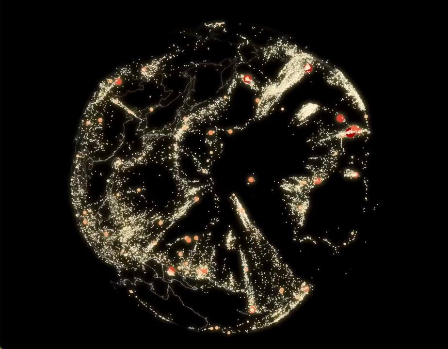
You're looking at earthquakes from inside the Earth. 🌏 Created by Raluca Nicola with the ArcGIS Maps SDK for JavaScript.
🔸Explore the app here: esri.social/BmH650UlkeR
#ArcGIS #JavaScript #geoscience #geography #edusky
🔸Explore the app here: esri.social/BmH650UlkeR
#ArcGIS #JavaScript #geoscience #geography #edusky
December 5, 2024 at 4:55 PM
You're looking at earthquakes from inside the Earth. 🌏 Created by Raluca Nicola with the ArcGIS Maps SDK for JavaScript.
🔸Explore the app here: esri.social/BmH650UlkeR
#ArcGIS #JavaScript #geoscience #geography #edusky
🔸Explore the app here: esri.social/BmH650UlkeR
#ArcGIS #JavaScript #geoscience #geography #edusky