


Mapping and Geographic Information Centre
@magic.bas.ac.uk
The Mapping and Geographic Information Centre (MAGIC) provides geospatial information, expertise, and services to the British Antarctic Survey (@bas.ac.uk) and wider UK activity in the Polar Regions.
Pinned

Hello 👋
We are the Mapping and Geographic Information Centre (MAGIC) at the British Antarctic Survey.
We produce maps of the polar regions, survey wildlife colonies and our stations, and provide the latest sea ice information through custom platforms.
Here's a quick intro to our work!
1/5
We are the Mapping and Geographic Information Centre (MAGIC) at the British Antarctic Survey.
We produce maps of the polar regions, survey wildlife colonies and our stations, and provide the latest sea ice information through custom platforms.
Here's a quick intro to our work!
1/5
We’ve been developing a 3D Digital Twin of Rothera, incorporating detailed Building Information Models (BIM) of the Discovery Building and other station facilities. We’ve also integrated live tracking data for our ship, aircraft, and vehicles. In this image you can see our ship docked at the wharf.

December 18, 2025 at 1:29 PM
We’ve been developing a 3D Digital Twin of Rothera, incorporating detailed Building Information Models (BIM) of the Discovery Building and other station facilities. We’ve also integrated live tracking data for our ship, aircraft, and vehicles. In this image you can see our ship docked at the wharf.
Happy Antarctica Day! We’ve recently updated this map to show consultative and non-consultative signatories of the Antarctic Treaty, signed on this day in 1959. The Treaty designates Antarctica a continent for peace and science. December 1st raises awareness of this global agreement and its goals.

December 1, 2025 at 5:01 PM
Happy Antarctica Day! We’ve recently updated this map to show consultative and non-consultative signatories of the Antarctic Treaty, signed on this day in 1959. The Treaty designates Antarctica a continent for peace and science. December 1st raises awareness of this global agreement and its goals.
GIS Asset Engineer Nicole starts her mission across Antarctic stations on Signy, capturing precise geographic locations of buildings and other structures to improve management of these remote sites. Her work helps teams plan and operate effectively in one of Earth’s most challenging environments.

November 26, 2025 at 2:35 PM
GIS Asset Engineer Nicole starts her mission across Antarctic stations on Signy, capturing precise geographic locations of buildings and other structures to improve management of these remote sites. Her work helps teams plan and operate effectively in one of Earth’s most challenging environments.
New data alert 🚨📣:
Updated Coastline and Rock Outcrop of Antarctica released as part of the @scar-antarctic.bsky.social Antarctic Digital Database. With big improvements to date formats, coastline positions and more accurate rock outcrop!
📍View and download via the map viewer add.scar.org.
Updated Coastline and Rock Outcrop of Antarctica released as part of the @scar-antarctic.bsky.social Antarctic Digital Database. With big improvements to date formats, coastline positions and more accurate rock outcrop!
📍View and download via the map viewer add.scar.org.


November 19, 2025 at 5:52 PM
New data alert 🚨📣:
Updated Coastline and Rock Outcrop of Antarctica released as part of the @scar-antarctic.bsky.social Antarctic Digital Database. With big improvements to date formats, coastline positions and more accurate rock outcrop!
📍View and download via the map viewer add.scar.org.
Updated Coastline and Rock Outcrop of Antarctica released as part of the @scar-antarctic.bsky.social Antarctic Digital Database. With big improvements to date formats, coastline positions and more accurate rock outcrop!
📍View and download via the map viewer add.scar.org.
We've recently created a new collection of legacy maps in our Catalogue, which will be added to over time. For now, we have 3 interesting maps available to view and download: data.bas.ac.uk/collections/...
The Scotia Arc is one of our favourites. The map was a massive compilation effort at the time!
The Scotia Arc is one of our favourites. The map was a massive compilation effort at the time!

November 7, 2025 at 2:34 PM
We've recently created a new collection of legacy maps in our Catalogue, which will be added to over time. For now, we have 3 interesting maps available to view and download: data.bas.ac.uk/collections/...
The Scotia Arc is one of our favourites. The map was a massive compilation effort at the time!
The Scotia Arc is one of our favourites. The map was a massive compilation effort at the time!
We ran a Map Giveaway for BAS staff & students this week, raising money for @mapaction.bsky.social! The maps were a mixture of beautiful, historical maps from the 70s and 80s, and previous versions of our main published maps. We had so much interest - thanks BAS for the support & generous donations!


October 31, 2025 at 11:43 AM
We ran a Map Giveaway for BAS staff & students this week, raising money for @mapaction.bsky.social! The maps were a mixture of beautiful, historical maps from the 70s and 80s, and previous versions of our main published maps. We had so much interest - thanks BAS for the support & generous donations!
After a short delay in Punta Arenas waiting for a weather window, our first team member is now at Rothera Research Station, Antarctica, after travelling over the Drake Passage on the Dash-7 aircraft. 🛩️ While there, they will provide geospatial support to BAS staff as the science field season begins.


October 28, 2025 at 10:15 AM
After a short delay in Punta Arenas waiting for a weather window, our first team member is now at Rothera Research Station, Antarctica, after travelling over the Drake Passage on the Dash-7 aircraft. 🛩️ While there, they will provide geospatial support to BAS staff as the science field season begins.
These maps are the result of a collaboration between SCAGI members (the SCAR Standing Committee on Antarctic Geographic Information) 🌍🤝 The maps are open & free to use - supporting research and safe air operations across Antarctica. Learn more: scar.org/library-data...
2/2
2/2
October 17, 2025 at 3:57 PM
These maps are the result of a collaboration between SCAGI members (the SCAR Standing Committee on Antarctic Geographic Information) 🌍🤝 The maps are open & free to use - supporting research and safe air operations across Antarctica. Learn more: scar.org/library-data...
2/2
2/2
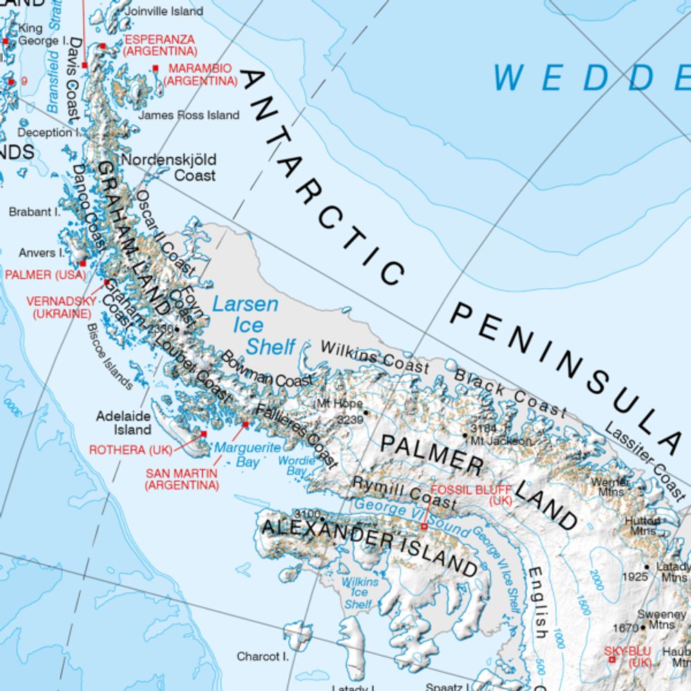
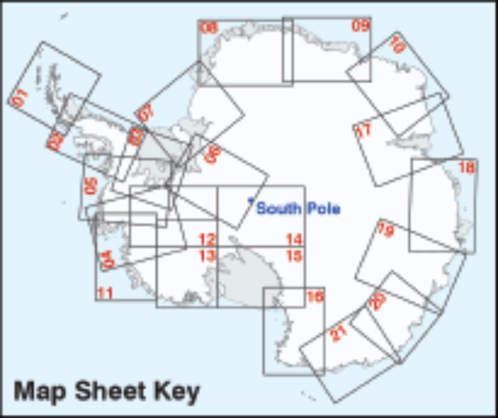
🚨 New maps alert!
Sheets 1–7 of the SCAR Air Operations Planning Maps Series are now live in our catalogue 🗺️✈️ @scar-antarctic.bsky.social
Explore detailed Antarctic mapping, designed to support science across the continent.
📍 Browse and download here: data.bas.ac.uk/collections/...
1/2
Sheets 1–7 of the SCAR Air Operations Planning Maps Series are now live in our catalogue 🗺️✈️ @scar-antarctic.bsky.social
Explore detailed Antarctic mapping, designed to support science across the continent.
📍 Browse and download here: data.bas.ac.uk/collections/...
1/2
SCAR Air Operations Planning Maps
A collection of SCAR Air Operations Planning Maps produced by the Mapping and Geographic Information Centre, British Antarctic Survey.
data.bas.ac.uk
October 17, 2025 at 3:57 PM
🚨 New maps alert!
Sheets 1–7 of the SCAR Air Operations Planning Maps Series are now live in our catalogue 🗺️✈️ @scar-antarctic.bsky.social
Explore detailed Antarctic mapping, designed to support science across the continent.
📍 Browse and download here: data.bas.ac.uk/collections/...
1/2
Sheets 1–7 of the SCAR Air Operations Planning Maps Series are now live in our catalogue 🗺️✈️ @scar-antarctic.bsky.social
Explore detailed Antarctic mapping, designed to support science across the continent.
📍 Browse and download here: data.bas.ac.uk/collections/...
1/2
Our first team member is soon starting her journey south to Antarctica, to provide geospatial support to BAS staff at Rothera! 🛫🏔️❄️
In the meantime, we've all been busy preparing new maps, data and geomatics equipment for the upcoming season. Stay tuned for lots of exciting updates and photos!
In the meantime, we've all been busy preparing new maps, data and geomatics equipment for the upcoming season. Stay tuned for lots of exciting updates and photos!
October 17, 2025 at 10:23 AM
Our first team member is soon starting her journey south to Antarctica, to provide geospatial support to BAS staff at Rothera! 🛫🏔️❄️
In the meantime, we've all been busy preparing new maps, data and geomatics equipment for the upcoming season. Stay tuned for lots of exciting updates and photos!
In the meantime, we've all been busy preparing new maps, data and geomatics equipment for the upcoming season. Stay tuned for lots of exciting updates and photos!
Some of our recent maps were reviewed for Geology Today & we're pleased to see the positive opinions & appreciation of how much work goes into them 🎉 doi.org/10.1111/gto....
The maps include The South Orkney Islands, Alexander Island, and Bedmap3. Details available in our catalogue - bas.ac.uk/maps
The maps include The South Orkney Islands, Alexander Island, and Bedmap3. Details available in our catalogue - bas.ac.uk/maps


October 6, 2025 at 11:05 AM
Some of our recent maps were reviewed for Geology Today & we're pleased to see the positive opinions & appreciation of how much work goes into them 🎉 doi.org/10.1111/gto....
The maps include The South Orkney Islands, Alexander Island, and Bedmap3. Details available in our catalogue - bas.ac.uk/maps
The maps include The South Orkney Islands, Alexander Island, and Bedmap3. Details available in our catalogue - bas.ac.uk/maps
Reposted by Mapping and Geographic Information Centre
A long term project comes to a close. We have been in Potsdam at the last meetings of the EU Arctic Passion project. Our final reporting about improving risk information for ships in sea ice is complete, but publications are coming. More information soon. www.arcticpassion.eu.

October 4, 2025 at 9:07 AM
A long term project comes to a close. We have been in Potsdam at the last meetings of the EU Arctic Passion project. Our final reporting about improving risk information for ships in sea ice is complete, but publications are coming. More information soon. www.arcticpassion.eu.
The programme and presentation slides can all be found here uk.osgeo.org/foss4guk2025...
Thanks again to @uk.osgeo.org for a great few days!
Thanks again to @uk.osgeo.org for a great few days!
October 3, 2025 at 11:00 AM
The programme and presentation slides can all be found here uk.osgeo.org/foss4guk2025...
Thanks again to @uk.osgeo.org for a great few days!
Thanks again to @uk.osgeo.org for a great few days!
We just attended #FOSS4GUK in Leeds. It was a fantastic couple of days meeting other GIS & software enthusiasts to learn about WWII coordinate systems, making maps accessible & much more, all using free & open tools anyone can use! We also presented the code and history behind our new map catalogue.


October 3, 2025 at 10:57 AM
We just attended #FOSS4GUK in Leeds. It was a fantastic couple of days meeting other GIS & software enthusiasts to learn about WWII coordinate systems, making maps accessible & much more, all using free & open tools anyone can use! We also presented the code and history behind our new map catalogue.
We're working on a new project to support building & modernisation at Rothera Research Station. This week we took part in a workshop showcasing how we will integrate 3D Building information models with our GIS platform and how it will form a key part of infrastructure planning and asset management.


October 2, 2025 at 3:08 PM
We're working on a new project to support building & modernisation at Rothera Research Station. This week we took part in a workshop showcasing how we will integrate 3D Building information models with our GIS platform and how it will form a key part of infrastructure planning and asset management.
Reposted by Mapping and Geographic Information Centre
We’re back from en excellent meeting at the annual International Ice Charting Working Group meeting in Tromsø. Lots of lively discussion, catching up with colleagues and we presented @bas.ac.uk work on AI for sea ice information plus the Ice Logistics Portal (www.icelogistics.info).

September 28, 2025 at 12:53 PM
We’re back from en excellent meeting at the annual International Ice Charting Working Group meeting in Tromsø. Lots of lively discussion, catching up with colleagues and we presented @bas.ac.uk work on AI for sea ice information plus the Ice Logistics Portal (www.icelogistics.info).
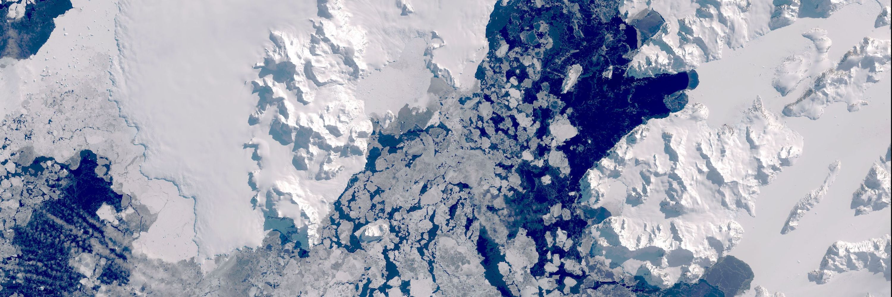
We've been using recent satellite imagery to update the @scar-antarctic.bsky.social Antarctic Digital Database coastline, in preparation for a new version of our 'Adelaide Island and Arrowsmith Peninsula' map. It's important to update this data, to track changes and portray the current conditions.


September 25, 2025 at 12:55 PM
We've been using recent satellite imagery to update the @scar-antarctic.bsky.social Antarctic Digital Database coastline, in preparation for a new version of our 'Adelaide Island and Arrowsmith Peninsula' map. It's important to update this data, to track changes and portray the current conditions.
Efe outlined his work on:
- Updating Antarctic topographic datasets
- Testing geospatial foundation deep learning models for rock outcrop segmentation
- Creating metadata records for historical maps
We’ve loved having his fresh perspective & energy on the team. Best of luck for the future, Efe!
2/2
- Updating Antarctic topographic datasets
- Testing geospatial foundation deep learning models for rock outcrop segmentation
- Creating metadata records for historical maps
We’ve loved having his fresh perspective & energy on the team. Best of luck for the future, Efe!
2/2
September 19, 2025 at 2:03 PM
Efe outlined his work on:
- Updating Antarctic topographic datasets
- Testing geospatial foundation deep learning models for rock outcrop segmentation
- Creating metadata records for historical maps
We’ve loved having his fresh perspective & energy on the team. Best of luck for the future, Efe!
2/2
- Updating Antarctic topographic datasets
- Testing geospatial foundation deep learning models for rock outcrop segmentation
- Creating metadata records for historical maps
We’ve loved having his fresh perspective & energy on the team. Best of luck for the future, Efe!
2/2
Our GIS Intern, @a-efe.bsky.social, is finishing his 12-week internship at @bas.ac.uk today. We want to say a big thank you for his fantastic contributions during this time with MAGIC!
Yesterday, Efe gave a final presentation to the team showcasing his work.
1/2
Yesterday, Efe gave a final presentation to the team showcasing his work.
1/2


September 19, 2025 at 2:03 PM
Our GIS Intern, @a-efe.bsky.social, is finishing his 12-week internship at @bas.ac.uk today. We want to say a big thank you for his fantastic contributions during this time with MAGIC!
Yesterday, Efe gave a final presentation to the team showcasing his work.
1/2
Yesterday, Efe gave a final presentation to the team showcasing his work.
1/2
A few of our favourite maps include:
* Bedmap3, showing Antarctica beneath the ice: data.bas.ac.uk/maps/bedmap3
* A beautiful map of Ny-Ålesund in Svalbard: data.bas.ac.uk/maps/2035
* and this map of the Arctic: data.bas.ac.uk/maps/1015
Read more at: www.bas.ac.uk/media-post/e...
2/2
* Bedmap3, showing Antarctica beneath the ice: data.bas.ac.uk/maps/bedmap3
* A beautiful map of Ny-Ålesund in Svalbard: data.bas.ac.uk/maps/2035
* and this map of the Arctic: data.bas.ac.uk/maps/1015
Read more at: www.bas.ac.uk/media-post/e...
2/2

Bedmap3 - Bed topography of Antarctica
These maps showcase Bedmap3, the latest suite of gridded products describing the surface elevation, ice-thickness and the seafloor and subglacial bed elevation of Antarctica south of 60°S.
data.bas.ac.uk
September 19, 2025 at 9:12 AM
A few of our favourite maps include:
* Bedmap3, showing Antarctica beneath the ice: data.bas.ac.uk/maps/bedmap3
* A beautiful map of Ny-Ålesund in Svalbard: data.bas.ac.uk/maps/2035
* and this map of the Arctic: data.bas.ac.uk/maps/1015
Read more at: www.bas.ac.uk/media-post/e...
2/2
* Bedmap3, showing Antarctica beneath the ice: data.bas.ac.uk/maps/bedmap3
* A beautiful map of Ny-Ålesund in Svalbard: data.bas.ac.uk/maps/2035
* and this map of the Arctic: data.bas.ac.uk/maps/1015
Read more at: www.bas.ac.uk/media-post/e...
2/2
We are so pleased to announce the official launch of the new BAS Map Catalogue 🎉🗺
The catalogue contains open access topographic, thematic and geological maps, as well as full details on where to purchase our professionally printed published maps.
Have a look for yourselves at bas.ac.uk/maps!
1/2
The catalogue contains open access topographic, thematic and geological maps, as well as full details on where to purchase our professionally printed published maps.
Have a look for yourselves at bas.ac.uk/maps!
1/2
🗺️NEW: BAS Map Catalogue is live!
Explore Antarctica and the Arctic through our collection of professional maps. Perfect for educators, adventurers, and polar enthusiasts. Many available on open licence for free download. #PolarMaps #Antarctica
Explore Antarctica and the Arctic through our collection of professional maps. Perfect for educators, adventurers, and polar enthusiasts. Many available on open licence for free download. #PolarMaps #Antarctica
September 19, 2025 at 9:12 AM
We are so pleased to announce the official launch of the new BAS Map Catalogue 🎉🗺
The catalogue contains open access topographic, thematic and geological maps, as well as full details on where to purchase our professionally printed published maps.
Have a look for yourselves at bas.ac.uk/maps!
1/2
The catalogue contains open access topographic, thematic and geological maps, as well as full details on where to purchase our professionally printed published maps.
Have a look for yourselves at bas.ac.uk/maps!
1/2
These awards are extremely competitive, with world-leading cartographic organisations entering multiple categories each year. We received Highly Commended and Commended awards, showing the value and importance of the work we carry out mapping the Polar Regions!

September 11, 2025 at 9:25 AM
These awards are extremely competitive, with world-leading cartographic organisations entering multiple categories each year. We received Highly Commended and Commended awards, showing the value and importance of the work we carry out mapping the Polar Regions!
We're very happy to share that three of our maps received awards at the @bcsmaps.bsky.social Annual Conference last week! Our Alexander Island and Bedmap3 maps were recognised in the Printed Mapping category, and our Ice Logistics Portal (www.icelogistics.info) in the Electronic Mapping category 🏆🎉


September 11, 2025 at 9:25 AM
We're very happy to share that three of our maps received awards at the @bcsmaps.bsky.social Annual Conference last week! Our Alexander Island and Bedmap3 maps were recognised in the Printed Mapping category, and our Ice Logistics Portal (www.icelogistics.info) in the Electronic Mapping category 🏆🎉
We've recently been testing our new laser scanner, acquired this year to enable accurate scanning of our facilities. It’s capturing in 3D now! MAGIC supports BIM modelling in Antarctica, where buildings will be scanned into point clouds to record detailed features - not even a socket will be missed.


September 9, 2025 at 9:28 AM
We've recently been testing our new laser scanner, acquired this year to enable accurate scanning of our facilities. It’s capturing in 3D now! MAGIC supports BIM modelling in Antarctica, where buildings will be scanned into point clouds to record detailed features - not even a socket will be missed.
A couple of our team are attending the @bcsmaps.bsky.social 2025 annual conference taking place at @bgs.ac.uk today and yesterday.
It has been a fascinating few days so far and it’s great to see our maps displayed for the awards ceremony later today! #carto2025
It has been a fascinating few days so far and it’s great to see our maps displayed for the awards ceremony later today! #carto2025


September 4, 2025 at 10:42 AM
A couple of our team are attending the @bcsmaps.bsky.social 2025 annual conference taking place at @bgs.ac.uk today and yesterday.
It has been a fascinating few days so far and it’s great to see our maps displayed for the awards ceremony later today! #carto2025
It has been a fascinating few days so far and it’s great to see our maps displayed for the awards ceremony later today! #carto2025