

Mapping and Geographic Information Centre
@magic.bas.ac.uk
The Mapping and Geographic Information Centre (MAGIC) provides geospatial information, expertise, and services to the British Antarctic Survey (@bas.ac.uk) and wider UK activity in the Polar Regions.
These maps are the result of a collaboration between SCAGI members (the SCAR Standing Committee on Antarctic Geographic Information) 🌍🤝 The maps are open & free to use - supporting research and safe air operations across Antarctica. Learn more: scar.org/library-data...
2/2
2/2
October 17, 2025 at 3:57 PM
These maps are the result of a collaboration between SCAGI members (the SCAR Standing Committee on Antarctic Geographic Information) 🌍🤝 The maps are open & free to use - supporting research and safe air operations across Antarctica. Learn more: scar.org/library-data...
2/2
2/2
The programme and presentation slides can all be found here uk.osgeo.org/foss4guk2025...
Thanks again to @uk.osgeo.org for a great few days!
Thanks again to @uk.osgeo.org for a great few days!
October 3, 2025 at 11:00 AM
The programme and presentation slides can all be found here uk.osgeo.org/foss4guk2025...
Thanks again to @uk.osgeo.org for a great few days!
Thanks again to @uk.osgeo.org for a great few days!
Efe outlined his work on:
- Updating Antarctic topographic datasets
- Testing geospatial foundation deep learning models for rock outcrop segmentation
- Creating metadata records for historical maps
We’ve loved having his fresh perspective & energy on the team. Best of luck for the future, Efe!
2/2
- Updating Antarctic topographic datasets
- Testing geospatial foundation deep learning models for rock outcrop segmentation
- Creating metadata records for historical maps
We’ve loved having his fresh perspective & energy on the team. Best of luck for the future, Efe!
2/2
September 19, 2025 at 2:03 PM
Efe outlined his work on:
- Updating Antarctic topographic datasets
- Testing geospatial foundation deep learning models for rock outcrop segmentation
- Creating metadata records for historical maps
We’ve loved having his fresh perspective & energy on the team. Best of luck for the future, Efe!
2/2
- Updating Antarctic topographic datasets
- Testing geospatial foundation deep learning models for rock outcrop segmentation
- Creating metadata records for historical maps
We’ve loved having his fresh perspective & energy on the team. Best of luck for the future, Efe!
2/2
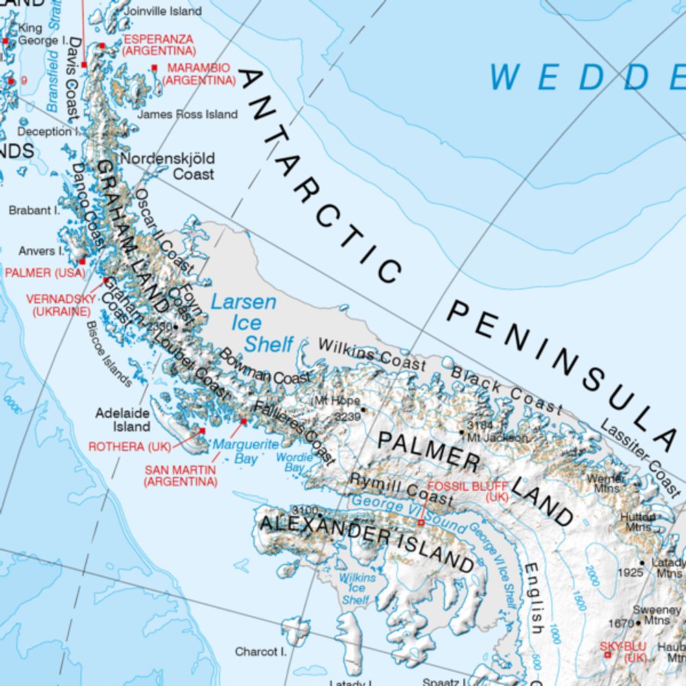
A few of our favourite maps include:
* Bedmap3, showing Antarctica beneath the ice: data.bas.ac.uk/maps/bedmap3
* A beautiful map of Ny-Ålesund in Svalbard: data.bas.ac.uk/maps/2035
* and this map of the Arctic: data.bas.ac.uk/maps/1015
Read more at: www.bas.ac.uk/media-post/e...
2/2
* Bedmap3, showing Antarctica beneath the ice: data.bas.ac.uk/maps/bedmap3
* A beautiful map of Ny-Ålesund in Svalbard: data.bas.ac.uk/maps/2035
* and this map of the Arctic: data.bas.ac.uk/maps/1015
Read more at: www.bas.ac.uk/media-post/e...
2/2

Bedmap3 - Bed topography of Antarctica
These maps showcase Bedmap3, the latest suite of gridded products describing the surface elevation, ice-thickness and the seafloor and subglacial bed elevation of Antarctica south of 60°S.
data.bas.ac.uk
September 19, 2025 at 9:12 AM
A few of our favourite maps include:
* Bedmap3, showing Antarctica beneath the ice: data.bas.ac.uk/maps/bedmap3
* A beautiful map of Ny-Ålesund in Svalbard: data.bas.ac.uk/maps/2035
* and this map of the Arctic: data.bas.ac.uk/maps/1015
Read more at: www.bas.ac.uk/media-post/e...
2/2
* Bedmap3, showing Antarctica beneath the ice: data.bas.ac.uk/maps/bedmap3
* A beautiful map of Ny-Ålesund in Svalbard: data.bas.ac.uk/maps/2035
* and this map of the Arctic: data.bas.ac.uk/maps/1015
Read more at: www.bas.ac.uk/media-post/e...
2/2
These awards are extremely competitive, with world-leading cartographic organisations entering multiple categories each year. We received Highly Commended and Commended awards, showing the value and importance of the work we carry out mapping the Polar Regions!

September 11, 2025 at 9:25 AM
These awards are extremely competitive, with world-leading cartographic organisations entering multiple categories each year. We received Highly Commended and Commended awards, showing the value and importance of the work we carry out mapping the Polar Regions!