


David Oxley
@wxdox.com
Virginia-based storm chaser and creator of #EZStormReport, streamlining the chasing and storm reporting experience on iOS: https://www.icloud.com/shortcuts/2fe4015cf88e47e29eac00325b7ac868. MS Johns Hopkins, BS Emory University. Personal Acct. #WxSky #VAwx
Pinned
David Oxley
@wxdox.com
· May 8
Happy to announce that my #EZStormReport iOS shortcut now support Bluesky and other social networks! All it takes is one additional step to paste, and NWS office X accounts are replaced with hashtags. Try out the easiest way to share severe weather reports on social media! Link in bio.

May 30, 2025 at 11:28 PM
(Checks forecast/models): Wow, a 5% RISK DAY in Virginia, time to grab my gear and…
(Friday work stuff) Well, I’ll just take off a little early and drive down to…
(Remembers it’s a Friday afternoon in VA terrain/traffic): Nah, I think I’m good, if it wants to come, I’m here.
(Friday work stuff) Well, I’ll just take off a little early and drive down to…
(Remembers it’s a Friday afternoon in VA terrain/traffic): Nah, I think I’m good, if it wants to come, I’m here.
May 30, 2025 at 6:42 PM
(Checks forecast/models): Wow, a 5% RISK DAY in Virginia, time to grab my gear and…
(Friday work stuff) Well, I’ll just take off a little early and drive down to…
(Remembers it’s a Friday afternoon in VA terrain/traffic): Nah, I think I’m good, if it wants to come, I’m here.
(Friday work stuff) Well, I’ll just take off a little early and drive down to…
(Remembers it’s a Friday afternoon in VA terrain/traffic): Nah, I think I’m good, if it wants to come, I’m here.
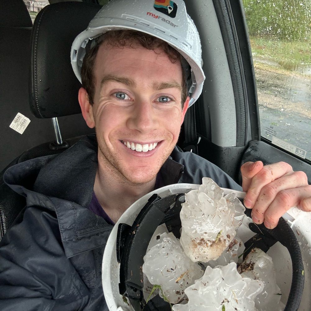
[0014z] Slightly larger than golf ball size hail. My location was 26.2607, -98.1862 near Lopezville, TX. #NWSBrownsville #TXwx #EZStormReport

May 9, 2025 at 12:27 AM
[0014z] Slightly larger than golf ball size hail. My location was 26.2607, -98.1862 near Lopezville, TX. #NWSBrownsville #TXwx #EZStormReport


May 8, 2025 at 11:24 PM
Just finished @matthewcappucci.bsky.social’s “Looking Up: The True Adventures of a Storm Chasing Weather Nerd” while on my Midwest chasecation. It’s a great, endearing read with a lot of infectious enthusiasm for all things weather. Hope to run into you chasing one day, Matt!

May 8, 2025 at 7:11 PM
Just finished @matthewcappucci.bsky.social’s “Looking Up: The True Adventures of a Storm Chasing Weather Nerd” while on my Midwest chasecation. It’s a great, endearing read with a lot of infectious enthusiasm for all things weather. Hope to run into you chasing one day, Matt!
Happy to announce that my #EZStormReport iOS shortcut now support Bluesky and other social networks! All it takes is one additional step to paste, and NWS office X accounts are replaced with hashtags. Try out the easiest way to share severe weather reports on social media! Link in bio.
May 8, 2025 at 4:50 PM
Happy to announce that my #EZStormReport iOS shortcut now support Bluesky and other social networks! All it takes is one additional step to paste, and NWS office X accounts are replaced with hashtags. Try out the easiest way to share severe weather reports on social media! Link in bio.


May 5, 2025 at 1:58 AM

May 4, 2025 at 3:42 AM
Reposted by David Oxley

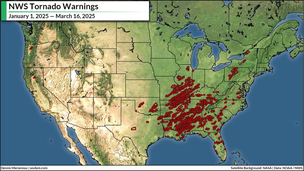
We've seen 513 tornado warning polygons in the U.S. so far this year as of 5:30 p.m today. Almost half of them have been issued since Friday.
March 16, 2025 at 9:40 PM
We've seen 513 tornado warning polygons in the U.S. so far this year as of 5:30 p.m today. Almost half of them have been issued since Friday.
Reposted by David Oxley
More proof that my colleagues at NWS SPC are the best in the business. Their service is no less than vital.

Another example of the outstanding work of the folks at the NWS Storm Prediction Center!
The initial risk area was denoted on the Day 6 Severe Weather Outlook with continued messaging of a significant severe weather threat up to the event day
*Note: Reports are preliminary (likely more to come)
The initial risk area was denoted on the Day 6 Severe Weather Outlook with continued messaging of a significant severe weather threat up to the event day
*Note: Reports are preliminary (likely more to come)
March 15, 2025 at 3:46 PM
More proof that my colleagues at NWS SPC are the best in the business. Their service is no less than vital.
Reposted by David Oxley

I really hope after tonight that more Americans will appreciate, understand, and value the significant and lifesaving work done by the National Weather Service, and NOAA in general.
March 15, 2025 at 6:12 AM
I really hope after tonight that more Americans will appreciate, understand, and value the significant and lifesaving work done by the National Weather Service, and NOAA in general.
Categorical High Risk day while I’m flying back from Europe 😬

a cat is hanging from a tree branch with the words `` stay safe out there '' written below it .
ALT: a cat is hanging from a tree branch with the words `` stay safe out there '' written below it .
media.tenor.com
March 15, 2025 at 9:07 AM
Categorical High Risk day while I’m flying back from Europe 😬
Reposted by David Oxley
Two rounds of severe weather are likely, which is concerning.
We'll have rotating supercells with STRONG tornado potential work across Louisiana and Mississippi this afternoon.
Then a squall line with embedded tornadoes pushes toward Alabama into the overnight.
Stay aware!
We'll have rotating supercells with STRONG tornado potential work across Louisiana and Mississippi this afternoon.
Then a squall line with embedded tornadoes pushes toward Alabama into the overnight.
Stay aware!

December 28, 2024 at 3:50 PM
Two rounds of severe weather are likely, which is concerning.
We'll have rotating supercells with STRONG tornado potential work across Louisiana and Mississippi this afternoon.
Then a squall line with embedded tornadoes pushes toward Alabama into the overnight.
Stay aware!
We'll have rotating supercells with STRONG tornado potential work across Louisiana and Mississippi this afternoon.
Then a squall line with embedded tornadoes pushes toward Alabama into the overnight.
Stay aware!
Reposted by David Oxley
December 10-11th, 2021:
The worst December outbreak in US history impacted the Midwest and Mid-South. 24 of the 71 confirmed twisters were significant (EF2+). Several dominant multi-state supercells were responsible for intense tornado families. 92 people were killed.
The worst December outbreak in US history impacted the Midwest and Mid-South. 24 of the 71 confirmed twisters were significant (EF2+). Several dominant multi-state supercells were responsible for intense tornado families. 92 people were killed.


December 10, 2024 at 1:24 PM
December 10-11th, 2021:
The worst December outbreak in US history impacted the Midwest and Mid-South. 24 of the 71 confirmed twisters were significant (EF2+). Several dominant multi-state supercells were responsible for intense tornado families. 92 people were killed.
The worst December outbreak in US history impacted the Midwest and Mid-South. 24 of the 71 confirmed twisters were significant (EF2+). Several dominant multi-state supercells were responsible for intense tornado families. 92 people were killed.
A detailed and fascinating look at the 2024 Atlantic Hurricane Season. How time flies by…

The 2024 Atlantic Hurricane Season will finally come to an end on November 30, and by any measure, it was an extremely active and impactful season.
bmcnoldy.blogspot.com/2024/11/summ...
@miamirosenstiel.bsky.social
@capitalweather.bsky.social
#HurricaneSeason
bmcnoldy.blogspot.com/2024/11/summ...
@miamirosenstiel.bsky.social
@capitalweather.bsky.social
#HurricaneSeason

Summary of the Hyperactive 2024 Hurricane Season
Updates and summaries on tropical Atlantic activity... including easterly waves, tropical storms, subtropical storms, and hurricanes.
bmcnoldy.blogspot.com
November 23, 2024 at 4:37 PM
A detailed and fascinating look at the 2024 Atlantic Hurricane Season. How time flies by…
Sadly missed out on a good shot while stuck in traffic, but managed this at least. The first tornado I had ever seen, and one of two I got to see that day!

November 18, 2024 at 3:47 AM
Sadly missed out on a good shot while stuck in traffic, but managed this at least. The first tornado I had ever seen, and one of two I got to see that day!
Reposted by David Oxley
Let's show some support to our great friend George Kourounis bsky.app/profile/geor... on his recently setup account.
bsky.app
November 16, 2024 at 11:42 PM
Let's show some support to our great friend George Kourounis bsky.app/profile/geor... on his recently setup account.
And I was so close to migrating my X posts to Bluesky via @en.blueark.app before the end of the week…alas. Looks like I’m stuck there for a bit longer.

November 16, 2024 at 1:42 AM
And I was so close to migrating my X posts to Bluesky via @en.blueark.app before the end of the week…alas. Looks like I’m stuck there for a bit longer.
Continuing to add new folks joining Bluesky to this starter pack, please let me know the folks I miss! go.bsky.app/J3e9fub
November 15, 2024 at 10:10 PM
Continuing to add new folks joining Bluesky to this starter pack, please let me know the folks I miss! go.bsky.app/J3e9fub
Excited to be part of #WxSky and the burgeoning storm chaser community here! Consider using this Storm Chaser Starter Pack I’ve created to help you find folks. I will continue to update the list, suggestions welcome! go.bsky.app/J3e9fub
November 13, 2024 at 3:42 AM
Excited to be part of #WxSky and the burgeoning storm chaser community here! Consider using this Storm Chaser Starter Pack I’ve created to help you find folks. I will continue to update the list, suggestions welcome! go.bsky.app/J3e9fub
A glimpse between the trees in Fairfax, VA! @capitalweather

November 16, 2024 at 8:52 AM
A glimpse between the trees in Fairfax, VA! @capitalweather
A bit of glow in Fairfax, VA

November 16, 2024 at 8:52 AM
A bit of glow in Fairfax, VA

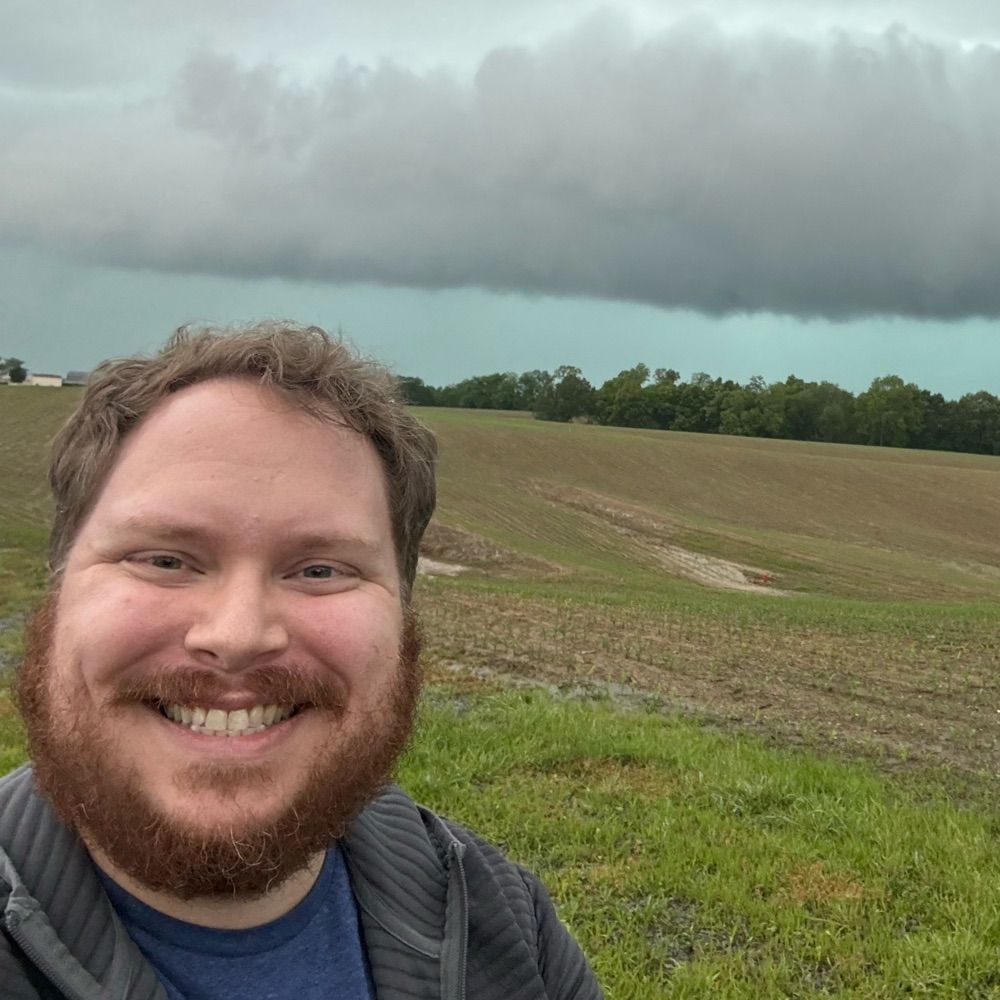
The closest I got today: a picture of the wall cloud forming on the back of the Leesburg cell that eventually spawned the Poolesville tornado. Went tornado-warned four minutes later before crossing the Potomac. #vawx


November 16, 2024 at 9:00 AM
The closest I got today: a picture of the wall cloud forming on the back of the Leesburg cell that eventually spawned the Poolesville tornado. Went tornado-warned four minutes later before crossing the Potomac. #vawx
So close to seeing the Poolesville MD tornado…if not for being in Leesburg initially and having to cross the Potomac and race the storm 😅
Lesson learned about positioning when chasing in VA/MD, plus trusting my instincts when I saw the meso recycling and should have pursued!
Lesson learned about positioning when chasing in VA/MD, plus trusting my instincts when I saw the meso recycling and should have pursued!
November 16, 2024 at 9:07 AM
So close to seeing the Poolesville MD tornado…if not for being in Leesburg initially and having to cross the Potomac and race the storm 😅
Lesson learned about positioning when chasing in VA/MD, plus trusting my instincts when I saw the meso recycling and should have pursued!
Lesson learned about positioning when chasing in VA/MD, plus trusting my instincts when I saw the meso recycling and should have pursued!