


Transitland
@transit.land
Buses, trains, subways, ferries, and more transit open to the public around the world. Aggregated from open-data feeds into a single API.
Explore at https://www.transit.land/map
For support post to https://github.com/transitland/transitland/discussions
Explore at https://www.transit.land/map
For support post to https://github.com/transitland/transitland/discussions
Explore GTFS-Pathways station data using Transitland's global transit map:
1) Click the gear icon to access advanced settings
2) Enable all stop types
3) Move your cursor over stop points
4) Notice the icons for station entrances and other station pathway nodes
(This example shows @mbta.com)
1) Click the gear icon to access advanced settings
2) Enable all stop types
3) Move your cursor over stop points
4) Notice the icons for station entrances and other station pathway nodes
(This example shows @mbta.com)
November 7, 2025 at 1:30 AM
Explore GTFS-Pathways station data using Transitland's global transit map:
1) Click the gear icon to access advanced settings
2) Enable all stop types
3) Move your cursor over stop points
4) Notice the icons for station entrances and other station pathway nodes
(This example shows @mbta.com)
1) Click the gear icon to access advanced settings
2) Enable all stop types
3) Move your cursor over stop points
4) Notice the icons for station entrances and other station pathway nodes
(This example shows @mbta.com)
Transitland's global transit map now provides info on bus, subway, train, and ferry stops around the world:
1) Zoom in
2) Click on a stop point
3) Drill down into Transitland's full depth of information, including real-time departures
Try Transitland global transit map at www.transit.land/map
1) Zoom in
2) Click on a stop point
3) Drill down into Transitland's full depth of information, including real-time departures
Try Transitland global transit map at www.transit.land/map
November 4, 2025 at 10:58 PM
Transitland's global transit map now provides info on bus, subway, train, and ferry stops around the world:
1) Zoom in
2) Click on a stop point
3) Drill down into Transitland's full depth of information, including real-time departures
Try Transitland global transit map at www.transit.land/map
1) Zoom in
2) Click on a stop point
3) Drill down into Transitland's full depth of information, including real-time departures
Try Transitland global transit map at www.transit.land/map
Whether you're an analyst learning your way around GTFS data or a transit agency staffer trying to quickly debug your own systems, Transitland now provides the tools you need to automatically parse and read GTFS Realtime feeds:
www.interline.io/blog/easily-...
www.interline.io/blog/easily-...

Easily inspect GTFS Realtime using Transitland's website or API
Web browsers and text editors can't open GTFS Realtime. But with Transitland, you now can.
www.interline.io
July 22, 2025 at 5:09 PM
Whether you're an analyst learning your way around GTFS data or a transit agency staffer trying to quickly debug your own systems, Transitland now provides the tools you need to automatically parse and read GTFS Realtime feeds:
www.interline.io/blog/easily-...
www.interline.io/blog/easily-...
Transitland parses thousands of #GTFS and GTFS Realtime feeds using our Go-based "transitland-lib" software library.
On the occasion of its v1.0.0 release, we thought we'd blog about its speed, flexibility, and capabilities:
On the occasion of its v1.0.0 release, we thought we'd blog about its speed, flexibility, and capabilities:
Announcing transitland-lib v1.0.0
We're pleased to announce the release of transitland-lib version 1.0.0. This software library, written in the Go programming language, is the foundation of the Transitland platform and integral to a…
www.interline.io
March 31, 2025 at 5:09 PM
Transitland parses thousands of #GTFS and GTFS Realtime feeds using our Go-based "transitland-lib" software library.
On the occasion of its v1.0.0 release, we thought we'd blog about its speed, flexibility, and capabilities:
On the occasion of its v1.0.0 release, we thought we'd blog about its speed, flexibility, and capabilities:
Together with a number of small refinements and large refactoring for future functionality, we've added a "dark" mode to the Transitland website. Try it out at https://www.transit.land
February 25, 2025 at 9:45 PM
Together with a number of small refinements and large refactoring for future functionality, we've added a "dark" mode to the Transitland website. Try it out at https://www.transit.land
The US Federal Transit Administration extended the comment period to January 29 re requiring transit agencies to insert their National Transit Database IDs into GTFS feeds.
Our critical feedback:
Our critical feedback:
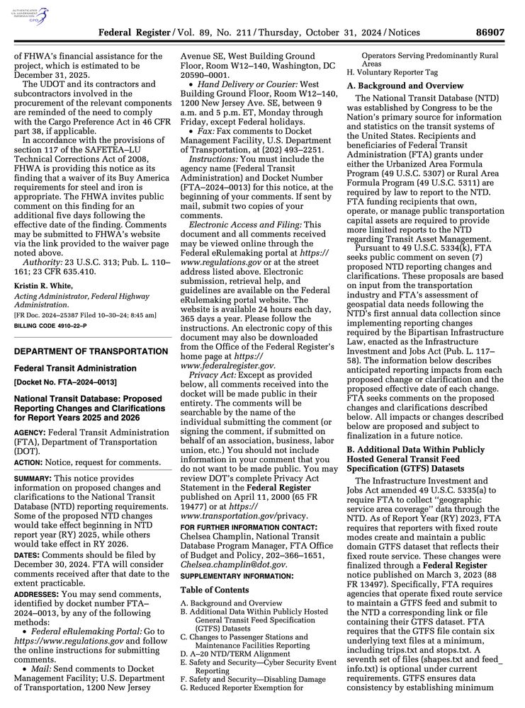
US National Transit Database releases data and requests more feedback
Our recommendations to the US Federal Transit Administration regarding National Transit Database: Proposed Reporting Changes and Clarifications for Report Years 2025 and 2026.
www.interline.io
January 13, 2025 at 5:00 PM
The US Federal Transit Administration extended the comment period to January 29 re requiring transit agencies to insert their National Transit Database IDs into GTFS feeds.
Our critical feedback:
Our critical feedback:
January 6, 2025 at 8:07 PM
Hello. Nice of Bluesky for letting us update our handle to @transit.land
December 3, 2024 at 12:34 AM
Hello. Nice of Bluesky for letting us update our handle to @transit.land
Reposted by Transitland

When I'm new to city, @transitland.bsky.social helps me understand its underlying mobility structure. TransitLand learned from @googlemaps.bsky.social excellence on street and highway scaling and applied to transit. Here's hoping all mobility mapping will focus on user utility rather than mode
November 27, 2024 at 5:24 AM
When I'm new to city, @transitland.bsky.social helps me understand its underlying mobility structure. TransitLand learned from @googlemaps.bsky.social excellence on street and highway scaling and applied to transit. Here's hoping all mobility mapping will focus on user utility rather than mode
Reposted by Transitland
I ❤️ Transitland. For most western North America and Global South cities, rapid buses are core mobility. Yet most maps elevate infrequent rail lines aimed at the elite. I love this update but worry it under-values rail in European and East Asian cities. Thoughts?
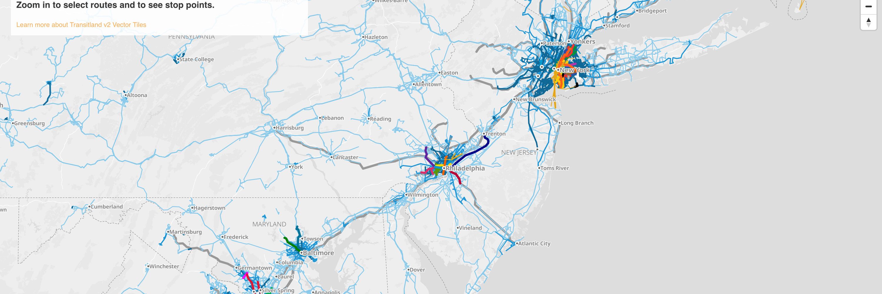
We've refined Transitland's global map to emphasize where riders can access the most frequent transit service.
Thanks to staff at San Francisco's transit agency (including @jeffreytumlin.bsky.social) for informing this improvement:
www.interline.io/blog/giving-...
Thanks to staff at San Francisco's transit agency (including @jeffreytumlin.bsky.social) for informing this improvement:
www.interline.io/blog/giving-...

Giving equal prominence to buses and trains on the map
We've refined Transitland's global map to emphasize where riders can access the most frequent transit service. Thanks to leaders at San Francisco's transit agency for informing this improvement.
www.interline.io
November 27, 2024 at 5:00 AM
I ❤️ Transitland. For most western North America and Global South cities, rapid buses are core mobility. Yet most maps elevate infrequent rail lines aimed at the elite. I love this update but worry it under-values rail in European and East Asian cities. Thoughts?
We've refined Transitland's global map to emphasize where riders can access the most frequent transit service.
Thanks to staff at San Francisco's transit agency (including @jeffreytumlin.bsky.social) for informing this improvement:
www.interline.io/blog/giving-...
Thanks to staff at San Francisco's transit agency (including @jeffreytumlin.bsky.social) for informing this improvement:
www.interline.io/blog/giving-...
Giving equal prominence to buses and trains on the map
We've refined Transitland's global map to emphasize where riders can access the most frequent transit service. Thanks to leaders at San Francisco's transit agency for informing this improvement.
www.interline.io
November 26, 2024 at 5:47 PM
We've refined Transitland's global map to emphasize where riders can access the most frequent transit service.
Thanks to staff at San Francisco's transit agency (including @jeffreytumlin.bsky.social) for informing this improvement:
www.interline.io/blog/giving-...
Thanks to staff at San Francisco's transit agency (including @jeffreytumlin.bsky.social) for informing this improvement:
www.interline.io/blog/giving-...