


Rich Briggs
@rangefront.bsky.social
just over here crashing my bike. Oh and random earthquake stuff.
Crap forgot to add my ridiculous opinions are sadly my own, unless you got in my head somehow. Nice work, you!
Crap forgot to add my ridiculous opinions are sadly my own, unless you got in my head somehow. Nice work, you!
Reposted by Rich Briggs

“Earthquakes and the damage they cause are apolitical… we either prepare for future earthquakes or the population eventually pays the price... In the U.S., this preparation hinges in large part on the expertise of scientists and engineers in federal agencies…”
theconversation.com/us-earthquak...
theconversation.com/us-earthquak...

US earthquake safety relies on federal employees’ expertise
The US experiences violent earthquakes, but the damage and death toll is much lower than in many countries because of the work of federal seismologists and engineers.
theconversation.com
April 2, 2025 at 12:54 AM
“Earthquakes and the damage they cause are apolitical… we either prepare for future earthquakes or the population eventually pays the price... In the U.S., this preparation hinges in large part on the expertise of scientists and engineers in federal agencies…”
theconversation.com/us-earthquak...
theconversation.com/us-earthquak...
Reposted by Rich Briggs

The whole #MyanmarEarthquake rupture in one interferogram! This is three consecutive wide swath frames of ALOS-2 data, provided by JAXA through agreement with NASA. The line-of-sight (LOS) is ~perpendicular to fault strike, so most of what you see is vertical motion at bends and steps of the fault.

April 2, 2025 at 11:14 PM
The whole #MyanmarEarthquake rupture in one interferogram! This is three consecutive wide swath frames of ALOS-2 data, provided by JAXA through agreement with NASA. The line-of-sight (LOS) is ~perpendicular to fault strike, so most of what you see is vertical motion at bends and steps of the fault.
USGS Myanmar earthquake remote surface rupture obervations 🔁REFRESH🔁
doi.org/10.5066/P1RY...
Offsets from Sentinel2 and Landsat pixel tracking ➡️ (slip blip at southern end; the rupture that can’t stop won’t stop)
On-fault offsets from high-res imagery ➡️ more detailed fault mapping
doi.org/10.5066/P1RY...
Offsets from Sentinel2 and Landsat pixel tracking ➡️ (slip blip at southern end; the rupture that can’t stop won’t stop)
On-fault offsets from high-res imagery ➡️ more detailed fault mapping


April 2, 2025 at 8:57 PM
USGS Myanmar earthquake remote surface rupture obervations 🔁REFRESH🔁
doi.org/10.5066/P1RY...
Offsets from Sentinel2 and Landsat pixel tracking ➡️ (slip blip at southern end; the rupture that can’t stop won’t stop)
On-fault offsets from high-res imagery ➡️ more detailed fault mapping
doi.org/10.5066/P1RY...
Offsets from Sentinel2 and Landsat pixel tracking ➡️ (slip blip at southern end; the rupture that can’t stop won’t stop)
On-fault offsets from high-res imagery ➡️ more detailed fault mapping
Reposted by Rich Briggs

⚒️ 🧪
New satellite imaging of the Myanmar earthquake area confirms that the rupture was unusually long: ~500 km.
We discuss the data, the rupture, and the implications, in our latest post.
earthquakeinsights.substack.com/p/surface-ru...
New satellite imaging of the Myanmar earthquake area confirms that the rupture was unusually long: ~500 km.
We discuss the data, the rupture, and the implications, in our latest post.
earthquakeinsights.substack.com/p/surface-ru...

Surface ruptures of the Myanmar M7.7 earthquake mapped from space
An extremely long rupture is confirmed
earthquakeinsights.substack.com
April 1, 2025 at 8:59 PM
⚒️ 🧪
New satellite imaging of the Myanmar earthquake area confirms that the rupture was unusually long: ~500 km.
We discuss the data, the rupture, and the implications, in our latest post.
earthquakeinsights.substack.com/p/surface-ru...
New satellite imaging of the Myanmar earthquake area confirms that the rupture was unusually long: ~500 km.
We discuss the data, the rupture, and the implications, in our latest post.
earthquakeinsights.substack.com/p/surface-ru...
Reposted by Rich Briggs

NASA JPL ARIA project analysis of data from Copernicus Sentinel-2 optical and Sentinel-1 radar images measured the slip on the Sagaing Fault in Myanmar. Quick preliminary map. More details later. Fault ruptured about 500 km (300 miles) in the magnitude 7.7 […]
[Original post on mastodon.social]
[Original post on mastodon.social]

April 1, 2025 at 6:36 PM
NASA JPL ARIA project analysis of data from Copernicus Sentinel-2 optical and Sentinel-1 radar images measured the slip on the Sagaing Fault in Myanmar. Quick preliminary map. More details later. Fault ruptured about 500 km (300 miles) in the magnitude 7.7 […]
[Original post on mastodon.social]
[Original post on mastodon.social]
Remote surface rupture observations for the M7.7 2025 Myanmar earthquake - soft rollout!
doi.org/10.5066/P1RY...
Simple fault trace and slip distribution from pixel tracking, high-res from available imagery. Watch for updates!
⚒️ USGS and collaborators effort led by @nadinegrr.bsky.social 🙏
doi.org/10.5066/P1RY...
Simple fault trace and slip distribution from pixel tracking, high-res from available imagery. Watch for updates!
⚒️ USGS and collaborators effort led by @nadinegrr.bsky.social 🙏

April 1, 2025 at 10:46 PM
Remote surface rupture observations for the M7.7 2025 Myanmar earthquake - soft rollout!
doi.org/10.5066/P1RY...
Simple fault trace and slip distribution from pixel tracking, high-res from available imagery. Watch for updates!
⚒️ USGS and collaborators effort led by @nadinegrr.bsky.social 🙏
doi.org/10.5066/P1RY...
Simple fault trace and slip distribution from pixel tracking, high-res from available imagery. Watch for updates!
⚒️ USGS and collaborators effort led by @nadinegrr.bsky.social 🙏
Heartfelt thanks to the USGS crew and others (especially @wangyu-1979.bsky.social) for working hard behind the scenes the last few days to confirm the loooong Myanmar rupture for the response products. Surface rupture imagery is bonkers. What a tragedy for the folks there, sending ♥️💔♥️
March 30, 2025 at 10:12 PM
Heartfelt thanks to the USGS crew and others (especially @wangyu-1979.bsky.social) for working hard behind the scenes the last few days to confirm the loooong Myanmar rupture for the response products. Surface rupture imagery is bonkers. What a tragedy for the folks there, sending ♥️💔♥️
Reposted by Rich Briggs
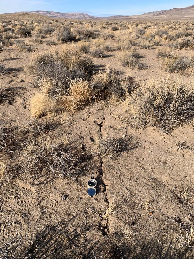
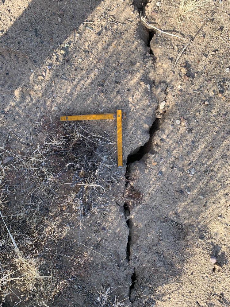
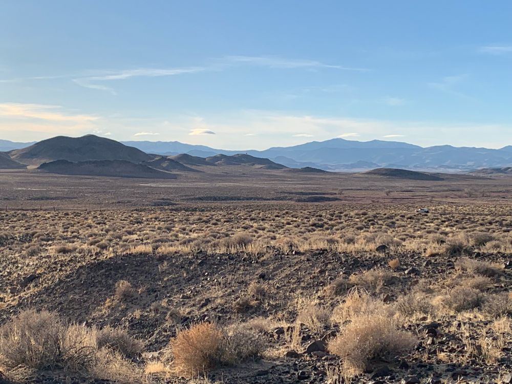
Magical INSAR led us to rupture from the M5.8 Parker Butte Nevada earthquake. 1.5 km of surface rupture, right lateral, max offsets 2-5 cm, on NNW plane. Conjugate to NE trending aftershocks.
December 18, 2024 at 6:12 AM
Magical INSAR led us to rupture from the M5.8 Parker Butte Nevada earthquake. 1.5 km of surface rupture, right lateral, max offsets 2-5 cm, on NNW plane. Conjugate to NE trending aftershocks.
Reposted by Rich Briggs
Curious about what the NVseismolab gets up to? Check out this video and follow us on Instagram for more behind the scenes action! 👉 www.instagram.com/share/BAV7Q5...
December 16, 2024 at 6:59 PM
Curious about what the NVseismolab gets up to? Check out this video and follow us on Instagram for more behind the scenes action! 👉 www.instagram.com/share/BAV7Q5...
Reposted by Rich Briggs
New trench excavated across the Alpine Fault at Blue Grey River. Definitely reverse dominant at this site. Thanks to @jameslagreca.bsky.social and Liv for their hard work. We were lucky with weather but eventually chased off by torrential rain.


December 16, 2024 at 7:33 PM
New trench excavated across the Alpine Fault at Blue Grey River. Definitely reverse dominant at this site. Thanks to @jameslagreca.bsky.social and Liv for their hard work. We were lucky with weather but eventually chased off by torrential rain.
Reposted by Rich Briggs
⚒️ Looking for a PhD in numerical modeling about earthquake cycle and surface deformation using Discrete Element Modelling?
Join us at IPGP, open position to start next Fall 2025.
Possibilities of funding for master internship prior to PhD if needed.
For information and application, just email me.
Join us at IPGP, open position to start next Fall 2025.
Possibilities of funding for master internship prior to PhD if needed.
For information and application, just email me.

December 16, 2024 at 4:42 PM
⚒️ Looking for a PhD in numerical modeling about earthquake cycle and surface deformation using Discrete Element Modelling?
Join us at IPGP, open position to start next Fall 2025.
Possibilities of funding for master internship prior to PhD if needed.
For information and application, just email me.
Join us at IPGP, open position to start next Fall 2025.
Possibilities of funding for master internship prior to PhD if needed.
For information and application, just email me.
Reposted by Rich Briggs
⚒️ If you are puzzled by shallow slip deficit during strike-slip earthquakes, maybe diffuse deformation is part of the answer.
S. Antoine et al. revisited the Ridgecrest earthquake and got ride of almost all of the SSD by better accounting for off fault deformation.
dx.doi.org/10.1029/2024...
S. Antoine et al. revisited the Ridgecrest earthquake and got ride of almost all of the SSD by better accounting for off fault deformation.
dx.doi.org/10.1029/2024...

December 16, 2024 at 11:12 AM
⚒️ If you are puzzled by shallow slip deficit during strike-slip earthquakes, maybe diffuse deformation is part of the answer.
S. Antoine et al. revisited the Ridgecrest earthquake and got ride of almost all of the SSD by better accounting for off fault deformation.
dx.doi.org/10.1029/2024...
S. Antoine et al. revisited the Ridgecrest earthquake and got ride of almost all of the SSD by better accounting for off fault deformation.
dx.doi.org/10.1029/2024...
Reposted by Rich Briggs

SPOILER ALERT: Went out to collect perishable data around yesterday's M5.8 epicentral region. Preliminary results: Nobody feels aftershocks when @faultcreeper.bsky.social is driving. Afternoon frozen slushy river makes for extremely cool co-seismic features (new types? to document!). 1/2
December 11, 2024 at 6:42 AM
SPOILER ALERT: Went out to collect perishable data around yesterday's M5.8 epicentral region. Preliminary results: Nobody feels aftershocks when @faultcreeper.bsky.social is driving. Afternoon frozen slushy river makes for extremely cool co-seismic features (new types? to document!). 1/2
Ok Nevada, don’t start any of this conjugate faulting stuff. Stay chill little bro

December 11, 2024 at 8:15 PM
Ok Nevada, don’t start any of this conjugate faulting stuff. Stay chill little bro
Reposted by Rich Briggs
Shout out to our field team who worked all night setting up temporary seismic stations near the epicenter of the ML 5.8 earthquake NNE of Yerington so we can better monitor aftershock activity.


December 10, 2024 at 11:56 PM
Shout out to our field team who worked all night setting up temporary seismic stations near the epicenter of the ML 5.8 earthquake NNE of Yerington so we can better monitor aftershock activity.
Reposted by Rich Briggs
A shaky day for us here in Nevada with a M5.5 earthquake NNE of Yearington at 3:08pm. Did you feel the shaking? Report it here earthquake.usgs.gov/earthquakes/...
The Earthquake Event Page application supports most recent browsers, view supported browsers. Or, try our Real-time Notifications, Feeds, and Web Services.
earthquake.usgs.gov
December 9, 2024 at 11:46 PM
A shaky day for us here in Nevada with a M5.5 earthquake NNE of Yearington at 3:08pm. Did you feel the shaking? Report it here earthquake.usgs.gov/earthquakes/...
Nevada doing Nevada things - likely l-l s-s on unmapped NE trending structure near Desert Mtns. Mw 5.5 earthquake.usgs.gov/earthquakes/... Screenshots lol


December 9, 2024 at 11:41 PM
Nevada doing Nevada things - likely l-l s-s on unmapped NE trending structure near Desert Mtns. Mw 5.5 earthquake.usgs.gov/earthquakes/... Screenshots lol
Reposted by Rich Briggs
An exciting PhD opportunity has come up w/ the Ngā Ngaru Wakapuke program in"Understanding earthquake sequences using near- and on-fault
paleoseismology on the western Marlborough Fault System". To work with leading paleoseismologists from VUW (J Howarth) & GNS. Contact k.clark@gns.cri.nz for pdf
paleoseismology on the western Marlborough Fault System". To work with leading paleoseismologists from VUW (J Howarth) & GNS. Contact k.clark@gns.cri.nz for pdf


November 24, 2024 at 9:05 PM
An exciting PhD opportunity has come up w/ the Ngā Ngaru Wakapuke program in"Understanding earthquake sequences using near- and on-fault
paleoseismology on the western Marlborough Fault System". To work with leading paleoseismologists from VUW (J Howarth) & GNS. Contact k.clark@gns.cri.nz for pdf
paleoseismology on the western Marlborough Fault System". To work with leading paleoseismologists from VUW (J Howarth) & GNS. Contact k.clark@gns.cri.nz for pdf
Reposted by Rich Briggs
New paper alert‼️
Prof. Heather Savage (UCSC) and Prof. Christie Rowe (UNR) characterized the size of slipping layers during earthquakes and how this influences the size of earthquake events through heat production and dissipation.
Check it out here: tinyurl.com/8xdj6wut
Prof. Heather Savage (UCSC) and Prof. Christie Rowe (UNR) characterized the size of slipping layers during earthquakes and how this influences the size of earthquake events through heat production and dissipation.
Check it out here: tinyurl.com/8xdj6wut

Localization and Delocalization During Seismic Slip
Seismic slip layers are ∼1 mm−1 cm thick, regardless of temperature, rock type, or depth, balancing heat production and dissipation
Thicker earthquake slip layers are possible but cannot be detec...
tinyurl.com
November 24, 2024 at 12:04 AM
New paper alert‼️
Prof. Heather Savage (UCSC) and Prof. Christie Rowe (UNR) characterized the size of slipping layers during earthquakes and how this influences the size of earthquake events through heat production and dissipation.
Check it out here: tinyurl.com/8xdj6wut
Prof. Heather Savage (UCSC) and Prof. Christie Rowe (UNR) characterized the size of slipping layers during earthquakes and how this influences the size of earthquake events through heat production and dissipation.
Check it out here: tinyurl.com/8xdj6wut
Rocks and clouds: Paleocene Green Mountain Conglomerate sitting on Paleocene/Upper Cretaceous Denver Formation. Oh and some cute lenticular clouds, and Red Rocks Amphitheater in the distance.
Classic Scott 1972 map: coloscisoc.org/wp-content/u...
Classic Scott 1972 map: coloscisoc.org/wp-content/u...


November 24, 2024 at 5:49 PM
Rocks and clouds: Paleocene Green Mountain Conglomerate sitting on Paleocene/Upper Cretaceous Denver Formation. Oh and some cute lenticular clouds, and Red Rocks Amphitheater in the distance.
Classic Scott 1972 map: coloscisoc.org/wp-content/u...
Classic Scott 1972 map: coloscisoc.org/wp-content/u...
Reposted by Rich Briggs

Today the California Geological Survey released new “Earthquake Zones of Required Investigation” maps (EZRIMs) for both Earthquake Fault Zones (aka “A-P Zones”) and Seismic Hazard Zones (Liquefaction and earthquake-induced landslides). www.conservation.ca.gov/cgs/publicat... 1/5
Publication Announcements
Release announcements of maps, reports and other publications of the California Geological Survey.
www.conservation.ca.gov
November 21, 2024 at 11:10 PM
Today the California Geological Survey released new “Earthquake Zones of Required Investigation” maps (EZRIMs) for both Earthquake Fault Zones (aka “A-P Zones”) and Seismic Hazard Zones (Liquefaction and earthquake-induced landslides). www.conservation.ca.gov/cgs/publicat... 1/5
Reposted by Rich Briggs

That time I dressed up as a sub-duck-shin zone.

November 21, 2024 at 1:56 AM
That time I dressed up as a sub-duck-shin zone.
Dog seen from couch

November 19, 2024 at 3:32 AM
Dog seen from couch
Reposted by Rich Briggs
It is finally online the paper brilliantly led by my friend @GeoJenni (Dr. Jenni Robertson) where we study the #QuaternaryUplift in SW #Crete, the area of 365 AD #CreteEarthquake (M 8.5).
https://www.sciencedirect.com/science/article/pii/S0277379123002883
https://www.sciencedirect.com/science/article/pii/S0277379123002883

August 19, 2023 at 6:48 AM
It is finally online the paper brilliantly led by my friend @GeoJenni (Dr. Jenni Robertson) where we study the #QuaternaryUplift in SW #Crete, the area of 365 AD #CreteEarthquake (M 8.5).
https://www.sciencedirect.com/science/article/pii/S0277379123002883
https://www.sciencedirect.com/science/article/pii/S0277379123002883
(blinks furiously in the bright light after coming out of the lab) There’s a special place in hell reserved for people who put too much tape on OSL sample tubes 💀🌋
November 18, 2024 at 8:15 PM
(blinks furiously in the bright light after coming out of the lab) There’s a special place in hell reserved for people who put too much tape on OSL sample tubes 💀🌋