


Eric Wright - asking for needed change
@quest4zero.bsky.social
Putting out things relative to climate change (try to keep to good science). Stopping it keeps nature and people—some other issues.
Trump said 'about some other cold wave ... "WHATEVER HAPPENED TO GLOBAL WARMING???"
Friday ice update - #Arctic sea ice extent is currently the *lowest* on record (JAXA data)...
• about 500,000 km² below the 2010s mean
• about 1,090,000 km² below the 2000s mean
• about 1,640,000 km² below the 1990s mean
• about 2,110,000 km² below the 1980s mean
More: zacklabe.com/arctic-sea-i...
• about 500,000 km² below the 2010s mean
• about 1,090,000 km² below the 2000s mean
• about 1,640,000 km² below the 1990s mean
• about 2,110,000 km² below the 1980s mean
More: zacklabe.com/arctic-sea-i...

January 23, 2026 at 7:16 PM
Trump said 'about some other cold wave ... "WHATEVER HAPPENED TO GLOBAL WARMING???"
Our difference from normal is so much greater than in normal years.
We continue to receive warning signs for our future. The data is in, and last year was the 3rd hottest on record for our planet...
+ Full report by @copernicusecmwf.bsky.social at climate.copernicus.eu/sites/defaul...
+ Full report by @copernicusecmwf.bsky.social at climate.copernicus.eu/sites/defaul...

January 14, 2026 at 5:42 PM
Our difference from normal is so much greater than in normal years.
When it balls up, large storms/loss of land ice take the shore. The heat is hard on ocean life.
2025 was the hottest year on record for ocean heat content. Unfortunately, we now say this every year. 🥹
"In addition to setting a new record in 2025, the global
ocean continues to show sustained and intensified warming."
+ #OpenAccess Study: doi.org/10.1007/s003...
+ Data: www.ocean.iap.ac.cn
"In addition to setting a new record in 2025, the global
ocean continues to show sustained and intensified warming."
+ #OpenAccess Study: doi.org/10.1007/s003...
+ Data: www.ocean.iap.ac.cn

January 10, 2026 at 6:36 PM
When it balls up, large storms/loss of land ice take the shore. The heat is hard on ocean life.
Reposted by Eric Wright - asking for needed change

Breaking News: President Trump said the U.S. would withdraw from the U.N.’s bedrock climate treaty, and 65 other treaties and agreements.

Trump Pulls Out of Global Climate Treaty
The action could make it more difficult for a future administration to rejoin the Paris climate accord, the agreement among most nations to fight climate change.
nyti.ms
January 8, 2026 at 1:00 AM
Breaking News: President Trump said the U.S. would withdraw from the U.N.’s bedrock climate treaty, and 65 other treaties and agreements.
Reposted by Eric Wright - asking for needed change

The first week of the new year is already flying by. Here's a look at how temperatures have changed around our planet over the last four decades in January...
Data from doi.org/10.24381/cds...
Data from doi.org/10.24381/cds...

January 6, 2026 at 11:13 PM
The first week of the new year is already flying by. Here's a look at how temperatures have changed around our planet over the last four decades in January...
Data from doi.org/10.24381/cds...
Data from doi.org/10.24381/cds...
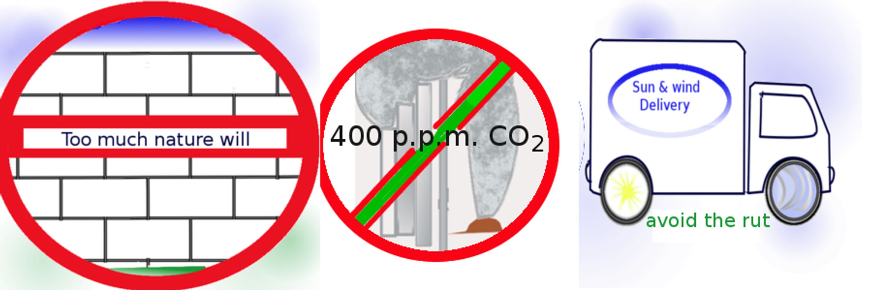
The government makes it more part of this by saying false things.

This is murder! Kristi and her goons along with the Predator President need to be in chains and thrown in a cage! POS!! #Pinks #SheShed #Minneapolis #ICE
January 8, 2026 at 4:19 AM
The government makes it more part of this by saying false things.
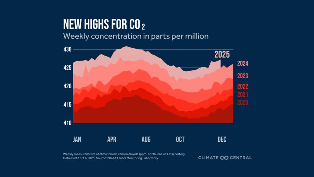
Far above the normal increase. ?
🚨 The first preliminary analysis from the Japan Meteorological Agency highlights 2025 as the third warmest year on record globally (since at least 1891 in this data).
Additional climate rankings will be released later for other datasets.
Graph and methods by ds.data.jma.go.jp/tcc/tcc/prod...
Additional climate rankings will be released later for other datasets.
Graph and methods by ds.data.jma.go.jp/tcc/tcc/prod...

January 2, 2026 at 3:39 PM
Far above the normal increase. ?
Reposted by Eric Wright - asking for needed change


Reposted by Eric Wright - asking for needed change
As always, my last post of the year reminder...
Reducing emissions will reduce future climate warming and impacts. The time is now. Visualization made by globalcarbonbudget.org.
Thanks for being here in 2025! I appreciate all the support 🙂
Reducing emissions will reduce future climate warming and impacts. The time is now. Visualization made by globalcarbonbudget.org.
Thanks for being here in 2025! I appreciate all the support 🙂
January 1, 2026 at 1:07 AM
As always, my last post of the year reminder...
Reducing emissions will reduce future climate warming and impacts. The time is now. Visualization made by globalcarbonbudget.org.
Thanks for being here in 2025! I appreciate all the support 🙂
Reducing emissions will reduce future climate warming and impacts. The time is now. Visualization made by globalcarbonbudget.org.
Thanks for being here in 2025! I appreciate all the support 🙂
Reposted by Eric Wright - asking for needed change
First daylight of 2026 reaches the entire Atlantic (visible on GOES-19 satellite at (www.star.nesdis.noaa.gov/GOES/fulldis...)
A #HappyNewYear to all of my @bsky.app followers! Thank you for another year of thoughtful interactions. I learn so much from you all every day. Cheers to 2026!
A #HappyNewYear to all of my @bsky.app followers! Thank you for another year of thoughtful interactions. I learn so much from you all every day. Cheers to 2026!
January 1, 2026 at 2:43 PM
First daylight of 2026 reaches the entire Atlantic (visible on GOES-19 satellite at (www.star.nesdis.noaa.gov/GOES/fulldis...)
A #HappyNewYear to all of my @bsky.app followers! Thank you for another year of thoughtful interactions. I learn so much from you all every day. Cheers to 2026!
A #HappyNewYear to all of my @bsky.app followers! Thank you for another year of thoughtful interactions. I learn so much from you all every day. Cheers to 2026!
Reposted by Eric Wright - asking for needed change
South Korean RV ARAON is indeed the only ship in the world regularly visiting Thwaites Glacier, Antarctica. US no longer has a dedicated Antarctic RV.
ARAON headed south now, with Raymond Zhong (NYT) & Miles O’Brien @pbsnews.org on board documenting! Gift link: www.nytimes.com/2025/12/27/c...
ARAON headed south now, with Raymond Zhong (NYT) & Miles O’Brien @pbsnews.org on board documenting! Gift link: www.nytimes.com/2025/12/27/c...

Bound for Antarctica: A Voyage to Earth’s End Is Underway
www.nytimes.com
December 27, 2025 at 4:35 PM
South Korean RV ARAON is indeed the only ship in the world regularly visiting Thwaites Glacier, Antarctica. US no longer has a dedicated Antarctic RV.
ARAON headed south now, with Raymond Zhong (NYT) & Miles O’Brien @pbsnews.org on board documenting! Gift link: www.nytimes.com/2025/12/27/c...
ARAON headed south now, with Raymond Zhong (NYT) & Miles O’Brien @pbsnews.org on board documenting! Gift link: www.nytimes.com/2025/12/27/c...
Add heat, get vapor with ocean (7/10), and lose it on land. You get this from boiling water and drying clothing.
100 years of November temperature anomalies over land areas through 2025...
Data from NOAAGlobalTemp v6.0.0: www.ncei.noaa.gov/products/lan...
Data from NOAAGlobalTemp v6.0.0: www.ncei.noaa.gov/products/lan...
December 29, 2025 at 3:52 AM
Add heat, get vapor with ocean (7/10), and lose it on land. You get this from boiling water and drying clothing.
The increasing water in the Arctic is making it warmer.
Check out the anomalous warmth across the #Arctic and #Antarctic over the last three months. And actually, all latitude bands averaged unusually warm too.
Plot shows zonal-mean temperature anomalies, where latitude = y-axis (not scaled by distance). GISTEMPv4 data using their 1951-1980 baseline.
Plot shows zonal-mean temperature anomalies, where latitude = y-axis (not scaled by distance). GISTEMPv4 data using their 1951-1980 baseline.

December 21, 2025 at 6:29 PM
The increasing water in the Arctic is making it warmer.
Many more graphics are available @zacklabe.com about what is with the weather.
Happy #DecemberSolstice! 🌞
Understanding seasons - a look at the hourly incoming solar radiation during the two solstices (23.5°N/S). I've added a red marker for ease of viewing. Dashed line shows the equator
This graphic can be found at zacklabe.com/arctic-clima...
Understanding seasons - a look at the hourly incoming solar radiation during the two solstices (23.5°N/S). I've added a red marker for ease of viewing. Dashed line shows the equator
This graphic can be found at zacklabe.com/arctic-clima...
December 21, 2025 at 1:22 PM
Many more graphics are available @zacklabe.com about what is with the weather.
It will most likely will act strangely .
Year-to-year variability with a long-term decline in November #Arctic sea ice volume (bar) and thickness (map). Updated through November 2025 🧊
Additional graphics: zacklabe.com/arctic-sea-i...
Additional graphics: zacklabe.com/arctic-sea-i...
December 15, 2025 at 1:24 AM
It will most likely will act strangely .
Thank you for keeping to topic alive; it is do high.
Join us! In a few days, @climatecentral.org will be launching a new webinar series on the state of our climate! I’ll provide monthly overviews of current global and U.S. conditions, along with special guests, featured topics, and written reports.
➡️ Sign up at www.climatecentral.org/climate-brie...
➡️ Sign up at www.climatecentral.org/climate-brie...
December 15, 2025 at 1:20 AM
Thank you for keeping to topic alive; it is do high.
Reposted by Eric Wright - asking for needed change
100 years of average January-November temperature anomalies over land areas through 2025...
Data from NOAAGlobalTemp v6.0.0: www.ncei.noaa.gov/products/lan...
Data from NOAAGlobalTemp v6.0.0: www.ncei.noaa.gov/products/lan...
December 14, 2025 at 1:45 AM
100 years of average January-November temperature anomalies over land areas through 2025...
Data from NOAAGlobalTemp v6.0.0: www.ncei.noaa.gov/products/lan...
Data from NOAAGlobalTemp v6.0.0: www.ncei.noaa.gov/products/lan...
Funny, Halifax, NS, Canada was cooler. But if you think this makes sense.
November 2025 observed more anomalous warmth across the entire Canadian Arctic Archipelago. The saturated red color indicates all of these areas were at least 5°C above the 1981-2010 average.
Data from doi.org/10.24381/cds...
Data from doi.org/10.24381/cds...

December 11, 2025 at 5:13 PM
Funny, Halifax, NS, Canada was cooler. But if you think this makes sense.
Reposted by Eric Wright - asking for needed change
"climate science"

According to a new court filing, the Trump administration has a six-page list of banned words that Head Start locations are forbidden from using when describing their programs.
Among the censored words: "disability," "race," "women," "trauma," "Gulf of Mexico." Short thread with the full list. 🧵
Among the censored words: "disability," "race," "women," "trauma," "Gulf of Mexico." Short thread with the full list. 🧵


December 11, 2025 at 1:41 AM
"climate science"
Blind to climate change; global warming is larger than them.

Oligarchy (noun):
A government of and by a few at the top, who exercise power for their own benefit. Their power and wealth increase as they make laws that favor themselves, manipulate financial markets, and create monopolies that put more wealth into their pockets.
A government of and by a few at the top, who exercise power for their own benefit. Their power and wealth increase as they make laws that favor themselves, manipulate financial markets, and create monopolies that put more wealth into their pockets.
December 9, 2025 at 5:32 PM
Blind to climate change; global warming is larger than them.
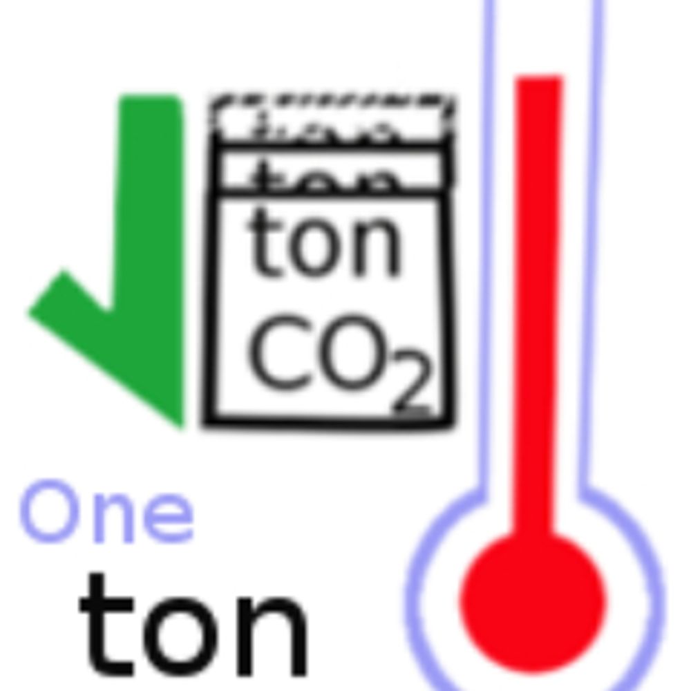
The work that has gone into knowing that it is the change in CO2! To vote matters.
"EPA erases references to human-caused climate change from websites"
"The agency modified sections of its website by deleting information about human-created greenhouse gases and the role they play in warming the planet. It also removed links to scientific data and information."
"The agency modified sections of its website by deleting information about human-created greenhouse gases and the role they play in warming the planet. It also removed links to scientific data and information."

EPA erases references to human-caused climate change from websites
The agency revamped its webpages to feature natural causes of rising temperatures such as the Earth’s orbit.
www.eenews.net
December 9, 2025 at 5:07 PM
The work that has gone into knowing that it is the change in CO2! To vote matters.
Larges drop, too!!!
🚨 Monday ice update - #Arctic sea ice extent is currently the lowest on record (JAXA data)
• about 840,000 km² below the 2010s mean
• about 1,390,000 km² below the 2000s mean
• about 2,050,000 km² below the 1990s mean
• about 2,510,000 km² below the 1980s mean
Graphics zacklabe.com/arctic-sea-i...
• about 840,000 km² below the 2010s mean
• about 1,390,000 km² below the 2000s mean
• about 2,050,000 km² below the 1990s mean
• about 2,510,000 km² below the 1980s mean
Graphics zacklabe.com/arctic-sea-i...

December 8, 2025 at 4:46 PM
Larges drop, too!!!
Larger drop than between any of these decade (between 2010-2000 490,000, 2000-1990 710,00, 1990-1980 500,00)
🚨 Monday ice update - #Arctic sea ice extent is currently the lowest on record (JAXA data)
• about 1,110,000 km² below the 2010s mean
• about 1,600,000 km² below the 2000s mean
• about 2,310,000 km² below the 1990s mean
• about 2,810,000 km² below the 1980s mean
More: zacklabe.com/arctic-sea-i...
• about 1,110,000 km² below the 2010s mean
• about 1,600,000 km² below the 2000s mean
• about 2,310,000 km² below the 1990s mean
• about 2,810,000 km² below the 1980s mean
More: zacklabe.com/arctic-sea-i...

December 1, 2025 at 4:56 PM
Larger drop than between any of these decade (between 2010-2000 490,000, 2000-1990 710,00, 1990-1980 500,00)
An unmistakable change!
The extent of global sea ice cover is more than 3 million square kilometers below the 1981-2010 average. This is the 2nd lowest on record for this date over the satellite-era.
Data from nsidc.org/data/seaice_...
Data from nsidc.org/data/seaice_...

November 29, 2025 at 3:14 PM
An unmistakable change!
Reposted by Eric Wright - asking for needed change
November is warming across large parts of the United States.
Check out some of the weather and climate extremes in your city on Thanksgiving from @climatecentral.org: www.climatecentral.org/climate-matt... 🦃
Check out some of the weather and climate extremes in your city on Thanksgiving from @climatecentral.org: www.climatecentral.org/climate-matt... 🦃

November 27, 2025 at 1:41 PM
November is warming across large parts of the United States.
Check out some of the weather and climate extremes in your city on Thanksgiving from @climatecentral.org: www.climatecentral.org/climate-matt... 🦃
Check out some of the weather and climate extremes in your city on Thanksgiving from @climatecentral.org: www.climatecentral.org/climate-matt... 🦃