


Reposted

Interested in cities, places, connectivity, & planning? Applications are open for fully-funded UCL ESRC doctoral studentships through the UBEL partnership. The deadline is 10 November. See further details & eligibility criteria at ubel-dtp.ac.uk/postdoctoral... Contact bartlett.phd-ecidi@ucl.ac.uk

October 13, 2025 at 3:39 PM
Interested in cities, places, connectivity, & planning? Applications are open for fully-funded UCL ESRC doctoral studentships through the UBEL partnership. The deadline is 10 November. See further details & eligibility criteria at ubel-dtp.ac.uk/postdoctoral... Contact bartlett.phd-ecidi@ucl.ac.uk
Reposted

Dutch zip codes (postcode) form a unique alphanumerical system in which one only needs the 4 digits and 2 letters combined with a house number to find any unique address in the country. Get the map: www.studiolegenda.com/produ... 🔹

Postcode Map of the Netherlands
The Dutch Postal Code Map of the Netherlands is truly a unique map. Every municipality is on this map, with every first two digits of the Dutch postal code system (postcode) represented in it. At the bottom you'll find a bit of history about the uniq
www.studiolegenda.com
October 5, 2025 at 5:30 PM
Dutch zip codes (postcode) form a unique alphanumerical system in which one only needs the 4 digits and 2 letters combined with a house number to find any unique address in the country. Get the map: www.studiolegenda.com/produ... 🔹
Reposted

Spectacular project studying the air quality exposure, physical activity and quality of life impacts of the TransMiCable in Bogota. Impressive community engaged research! Presentation by Dr. Olga Lucia Sarmiento at the 2025 Urban Health Symposium, Drexel U. #HealthInCities

September 5, 2025 at 2:07 PM
Spectacular project studying the air quality exposure, physical activity and quality of life impacts of the TransMiCable in Bogota. Impressive community engaged research! Presentation by Dr. Olga Lucia Sarmiento at the 2025 Urban Health Symposium, Drexel U. #HealthInCities
Reposted

A Borges story about a guy who gets AI to summarize all the world’s information for him, and then summarize the summary, until the AI has the whole world summarized into a single word. He sits alone at his desk, staring at the word, repeating it endlessly, certain he is experiencing everything
July 14, 2025 at 3:02 PM
A Borges story about a guy who gets AI to summarize all the world’s information for him, and then summarize the summary, until the AI has the whole world summarized into a single word. He sits alone at his desk, staring at the word, repeating it endlessly, certain he is experiencing everything

Reposted

A Call for Papers has just been published in the IEEE Journal of Selected Topics in Applied Earth Observations and Remote Sensing (JSTARS). The Special Issue is titled “Advancing Urban Remote Sensing for Sustainable and Resilient Cities“ co-editored by EORC and DLR remote-sensing.org/special-issu...

June 27, 2025 at 6:35 PM
A Call for Papers has just been published in the IEEE Journal of Selected Topics in Applied Earth Observations and Remote Sensing (JSTARS). The Special Issue is titled “Advancing Urban Remote Sensing for Sustainable and Resilient Cities“ co-editored by EORC and DLR remote-sensing.org/special-issu...
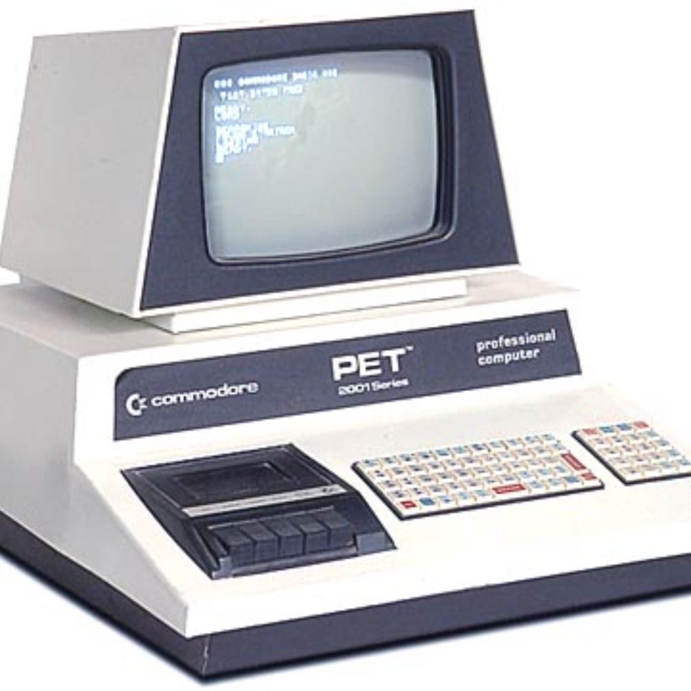
Yo tenía esa tele 😞
INTRODUCING SONY WATCHMAN PERSONAL TV. SONY: THE ONE AND ONLY.

June 26, 2025 at 12:55 AM
Yo tenía esa tele 😞
Reposted

Exciting update! Data from #CopernicusAtmosphere is now part of the @unep.org's IMEO @methanedata.bsky.social ta. The integration offers enhanced insights into methane emissions through TROPOMI on Sentinel-5P, helping monitor global methane emissions.
methanedata.unep.org/map?mars=&co...
methanedata.unep.org/map?mars=&co...

June 20, 2025 at 9:23 AM
Exciting update! Data from #CopernicusAtmosphere is now part of the @unep.org's IMEO @methanedata.bsky.social ta. The integration offers enhanced insights into methane emissions through TROPOMI on Sentinel-5P, helping monitor global methane emissions.
methanedata.unep.org/map?mars=&co...
methanedata.unep.org/map?mars=&co...
Reposted

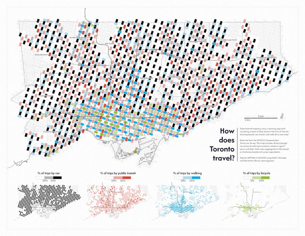
recent experiment mapping daily travel mode share in Toronto via weaving space
more info about this little project here: schoolofcities.github.io/transportati...
#toronto #maps #gis #dataviz
more info about this little project here: schoolofcities.github.io/transportati...
#toronto #maps #gis #dataviz
June 13, 2025 at 12:02 PM
recent experiment mapping daily travel mode share in Toronto via weaving space
more info about this little project here: schoolofcities.github.io/transportati...
#toronto #maps #gis #dataviz
more info about this little project here: schoolofcities.github.io/transportati...
#toronto #maps #gis #dataviz
Reposted

Release notes from the 1.4 release of @mystmd.org - the team made a bunch of improvements on social media links, plugin functionality, and documentation for contributors and developers!
github.com/jupyter-book...
github.com/jupyter-book...
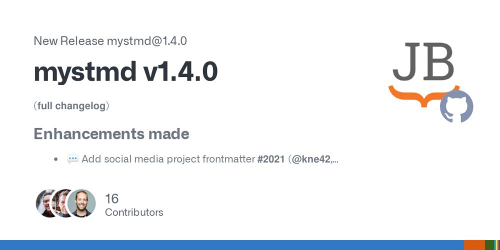
Release mystmd v1.4.0 · jupyter-book/mystmd
(full changelog)
Enhancements made
💬 Add social media project frontmatter #2021 (@kne42, @agoose77, @fwkoch, @rowanc1, @choldgraf, @artoftheblue)
Complete ipynb export support #1915 (@kp992, @agoo...
github.com
June 13, 2025 at 1:49 PM
Release notes from the 1.4 release of @mystmd.org - the team made a bunch of improvements on social media links, plugin functionality, and documentation for contributors and developers!
github.com/jupyter-book...
github.com/jupyter-book...
Reposted

TiTiler-CMR
Dynamic tiling for Earth data
→ Pulls data straight from NASA’s CMR
→ Works with NetCDF, HDF5, COGs
→ Powers VEDA’s IMERG + HLS products
→ Fully open source
Blog: www.earthdata.nasa.gov/news/blog/vi...
Repo: developmentseed.org/titiler-cmr/...
Demo: www.loom.com/share/af6fef...
Dynamic tiling for Earth data
→ Pulls data straight from NASA’s CMR
→ Works with NetCDF, HDF5, COGs
→ Powers VEDA’s IMERG + HLS products
→ Fully open source
Blog: www.earthdata.nasa.gov/news/blog/vi...
Repo: developmentseed.org/titiler-cmr/...
Demo: www.loom.com/share/af6fef...
June 13, 2025 at 10:39 PM
TiTiler-CMR
Dynamic tiling for Earth data
→ Pulls data straight from NASA’s CMR
→ Works with NetCDF, HDF5, COGs
→ Powers VEDA’s IMERG + HLS products
→ Fully open source
Blog: www.earthdata.nasa.gov/news/blog/vi...
Repo: developmentseed.org/titiler-cmr/...
Demo: www.loom.com/share/af6fef...
Dynamic tiling for Earth data
→ Pulls data straight from NASA’s CMR
→ Works with NetCDF, HDF5, COGs
→ Powers VEDA’s IMERG + HLS products
→ Fully open source
Blog: www.earthdata.nasa.gov/news/blog/vi...
Repo: developmentseed.org/titiler-cmr/...
Demo: www.loom.com/share/af6fef...
Reposted

Trump administration cuts are threatening the National Geodetic Survey, a tiny but crucial office within the NOAA that maintains the US’s framework of spatial information: latitudes, longitudes, elevation measurements, and more.
Trump Cuts Are Killing a Tiny Office That Keeps Measurements of the World Accurate
A tiny but crucial agency that maintains physical coordinates like latitude and longitude in the US is struggling as the Trump administration forces out federal employees.
www.wired.com
May 21, 2025 at 5:38 PM
Trump administration cuts are threatening the National Geodetic Survey, a tiny but crucial office within the NOAA that maintains the US’s framework of spatial information: latitudes, longitudes, elevation measurements, and more.
Reposted
jupytergis-tiler allows to visualize local or remote Xarray datasets in JupyterGIS.
It doesn't matter if the data is huge and doesn't fit in memory, the tiler will render to the screen just what you need to see.
All powered by @developmentseed.org's awesome TiTiler!
github.com/geojupyter/j...
It doesn't matter if the data is huge and doesn't fit in memory, the tiler will render to the screen just what you need to see.
All powered by @developmentseed.org's awesome TiTiler!
github.com/geojupyter/j...
May 23, 2025 at 7:48 AM
jupytergis-tiler allows to visualize local or remote Xarray datasets in JupyterGIS.
It doesn't matter if the data is huge and doesn't fit in memory, the tiler will render to the screen just what you need to see.
All powered by @developmentseed.org's awesome TiTiler!
github.com/geojupyter/j...
It doesn't matter if the data is huge and doesn't fit in memory, the tiler will render to the screen just what you need to see.
All powered by @developmentseed.org's awesome TiTiler!
github.com/geojupyter/j...
Reposted
Made two animated globes using gdal, ffmpeg, and ai2html for this story (gift link): www.nytimes.com/2025/05/03/w...
May 4, 2025 at 6:59 PM
Made two animated globes using gdal, ffmpeg, and ai2html for this story (gift link): www.nytimes.com/2025/05/03/w...
Reposted

The AI jobs crisis is not coming—it's here right now. It just might not look the way many thought it would.
www.bloodinthemachine.com/p/the-ai-job...
www.bloodinthemachine.com/p/the-ai-job...
The AI jobs crisis is here, now
It's not coming, it has already arrived.
www.bloodinthemachine.com
May 2, 2025 at 4:25 PM
The AI jobs crisis is not coming—it's here right now. It just might not look the way many thought it would.
www.bloodinthemachine.com/p/the-ai-job...
www.bloodinthemachine.com/p/the-ai-job...
Reposted

Vibe coding at its finest

April 19, 2025 at 3:38 PM
Vibe coding at its finest
Reposted

"Fundamentals: What is Cloud-Optimized Scientific Data?
Why naively lifting scientific data to the cloud falls flat."
earthmover.io/blog/fundame...
Thank you @tegnicholas.bsky.social
Why naively lifting scientific data to the cloud falls flat."
earthmover.io/blog/fundame...
Thank you @tegnicholas.bsky.social

April 17, 2025 at 6:39 PM
"Fundamentals: What is Cloud-Optimized Scientific Data?
Why naively lifting scientific data to the cloud falls flat."
earthmover.io/blog/fundame...
Thank you @tegnicholas.bsky.social
Why naively lifting scientific data to the cloud falls flat."
earthmover.io/blog/fundame...
Thank you @tegnicholas.bsky.social
Reposted

Updated the GitHub repo with a list of Geospatial Conferences 2025 🌍
Covers events on GIS, remote sensing, and more.
Browse the list and improve it here: https://github.com/Nowosad/conferences_2025
#geospatial #gischat #remotesensing #geo2025
Covers events on GIS, remote sensing, and more.
Browse the list and improve it here: https://github.com/Nowosad/conferences_2025
#geospatial #gischat #remotesensing #geo2025

April 13, 2025 at 2:10 PM
Updated the GitHub repo with a list of Geospatial Conferences 2025 🌍
Covers events on GIS, remote sensing, and more.
Browse the list and improve it here: https://github.com/Nowosad/conferences_2025
#geospatial #gischat #remotesensing #geo2025
Covers events on GIS, remote sensing, and more.
Browse the list and improve it here: https://github.com/Nowosad/conferences_2025
#geospatial #gischat #remotesensing #geo2025

Reposted

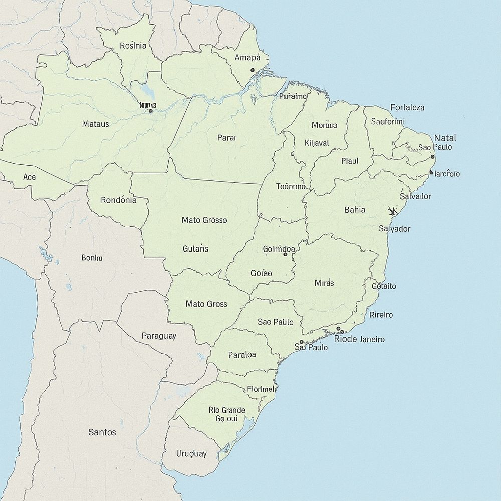
Mapa do Brasil gerado por 4 IAs diferentes: GPT, Grok, Meta Claude. Só a título de exemplo mais dramático. A internet vai encher de material produzidos por elas e uma vai se alimentar do erro da outra. Uma centopeia não-humana de propagação de erros.


April 14, 2025 at 5:38 PM
Mapa do Brasil gerado por 4 IAs diferentes: GPT, Grok, Meta Claude. Só a título de exemplo mais dramático. A internet vai encher de material produzidos por elas e uma vai se alimentar do erro da outra. Uma centopeia não-humana de propagação de erros.
Reposted

Reposted
🚀 New preprint! "Spatial Data Science Languages: Commonalities and Needs" 🌍
Exploring challenges & insights from #rstats #python & #julialang for spatial data handling—geodetic coords, data cubes, and more!
🔗 Read here: https://arxiv.org/html/2503.16686v1 […]
[Original post on fosstodon.org]
Exploring challenges & insights from #rstats #python & #julialang for spatial data handling—geodetic coords, data cubes, and more!
🔗 Read here: https://arxiv.org/html/2503.16686v1 […]
[Original post on fosstodon.org]


April 9, 2025 at 2:01 PM
🚀 New preprint! "Spatial Data Science Languages: Commonalities and Needs" 🌍
Exploring challenges & insights from #rstats #python & #julialang for spatial data handling—geodetic coords, data cubes, and more!
🔗 Read here: https://arxiv.org/html/2503.16686v1 […]
[Original post on fosstodon.org]
Exploring challenges & insights from #rstats #python & #julialang for spatial data handling—geodetic coords, data cubes, and more!
🔗 Read here: https://arxiv.org/html/2503.16686v1 […]
[Original post on fosstodon.org]
Reposted
Some recent maps built with @maplibre.org @protomaps.com


April 6, 2025 at 10:39 PM
Some recent maps built with @maplibre.org @protomaps.com
Reposted

To be an operator is to be a certain kind of generalist, but also one focused on a singular goal.
Your job is to take some North Star (generally defined by a set of company metrics or some big goal) and then manage a budget to directionally toward that North Star.
2/
Your job is to take some North Star (generally defined by a set of company metrics or some big goal) and then manage a budget to directionally toward that North Star.
2/
March 16, 2025 at 1:39 PM
To be an operator is to be a certain kind of generalist, but also one focused on a singular goal.
Your job is to take some North Star (generally defined by a set of company metrics or some big goal) and then manage a budget to directionally toward that North Star.
2/
Your job is to take some North Star (generally defined by a set of company metrics or some big goal) and then manage a budget to directionally toward that North Star.
2/
Reposted

"Objectivity must be operationally defined as fair treatment of data, not absence of preference."
Stephen Jay Gould wrote that more than three decades ago, but elite journalism hasn't grasped his point to this day.
Stephen Jay Gould wrote that more than three decades ago, but elite journalism hasn't grasped his point to this day.
March 15, 2025 at 2:24 AM
"Objectivity must be operationally defined as fair treatment of data, not absence of preference."
Stephen Jay Gould wrote that more than three decades ago, but elite journalism hasn't grasped his point to this day.
Stephen Jay Gould wrote that more than three decades ago, but elite journalism hasn't grasped his point to this day.