


Pinned
Development Seed
@developmentseed.org
· Oct 29
We made a Starter Pack of all our team members on Bluesky. Give them a follow to hear about the cool things they are working on.
go.bsky.app/Rgbegts
go.bsky.app/Rgbegts
Anthony Boyd and Wille Marcel are speaking at ICTC 2026 in Lima 🇵🇪
On Feb 19, they’ll share practical ways to choose open-source geospatial tools based on real project needs, plus a lightning talk on interactive storytelling with NASA’s VEDA.
Hope to see folks there. Hablamos español.
On Feb 19, they’ll share practical ways to choose open-source geospatial tools based on real project needs, plus a lightning talk on interactive storytelling with NASA’s VEDA.
Hope to see folks there. Hablamos español.

February 10, 2026 at 9:57 PM
Anthony Boyd and Wille Marcel are speaking at ICTC 2026 in Lima 🇵🇪
On Feb 19, they’ll share practical ways to choose open-source geospatial tools based on real project needs, plus a lightning talk on interactive storytelling with NASA’s VEDA.
Hope to see folks there. Hablamos español.
On Feb 19, they’ll share practical ways to choose open-source geospatial tools based on real project needs, plus a lightning talk on interactive storytelling with NASA’s VEDA.
Hope to see folks there. Hablamos español.
Reposted by Development Seed
Join us on Tuesday, Feb 24th, for an epic send-off for our Washington, DC office. Food, beverages, music, community & memories!
RSVP: luma.com/d8leo2k9
RSVP: luma.com/d8leo2k9

February 4, 2026 at 7:27 PM
Join us on Tuesday, Feb 24th, for an epic send-off for our Washington, DC office. Food, beverages, music, community & memories!
RSVP: luma.com/d8leo2k9
RSVP: luma.com/d8leo2k9
Just published: our story working with the Vanuatu Bureau of Statistics to make climate science and satellite data practical for local decision-making.
Tutorials & an interactive dashboard are open and reusable.
Read more: ds.io/vanuatu
Tutorials & an interactive dashboard are open and reusable.
Read more: ds.io/vanuatu

February 9, 2026 at 5:46 PM
Just published: our story working with the Vanuatu Bureau of Statistics to make climate science and satellite data practical for local decision-making.
Tutorials & an interactive dashboard are open and reusable.
Read more: ds.io/vanuatu
Tutorials & an interactive dashboard are open and reusable.
Read more: ds.io/vanuatu
What does “cloud‑friendly” Earth data mean?
In this @thrivegeo.bsky.social interview, @yayyyimee.bsky.social breaks it down — from NASA’s cloud migration to why geospatial needs its own “Amazon fulfillment center” moment.
Great listen!
scenefromabove.podbean.com/e/scene-from...
In this @thrivegeo.bsky.social interview, @yayyyimee.bsky.social breaks it down — from NASA’s cloud migration to why geospatial needs its own “Amazon fulfillment center” moment.
Great listen!
scenefromabove.podbean.com/e/scene-from...

February 6, 2026 at 7:11 PM
What does “cloud‑friendly” Earth data mean?
In this @thrivegeo.bsky.social interview, @yayyyimee.bsky.social breaks it down — from NASA’s cloud migration to why geospatial needs its own “Amazon fulfillment center” moment.
Great listen!
scenefromabove.podbean.com/e/scene-from...
In this @thrivegeo.bsky.social interview, @yayyyimee.bsky.social breaks it down — from NASA’s cloud migration to why geospatial needs its own “Amazon fulfillment center” moment.
Great listen!
scenefromabove.podbean.com/e/scene-from...
Join us on Tuesday, Feb 24th, for an epic send-off for our Washington, DC office. Food, beverages, music, community & memories!
RSVP: luma.com/d8leo2k9
RSVP: luma.com/d8leo2k9
February 4, 2026 at 7:27 PM
Join us on Tuesday, Feb 24th, for an epic send-off for our Washington, DC office. Food, beverages, music, community & memories!
RSVP: luma.com/d8leo2k9
RSVP: luma.com/d8leo2k9

Reposted by Development Seed

Introducing 𝐀𝐬𝐲𝐧𝐜-𝐆𝐞𝐨𝐓𝐈𝐅𝐅, a new library for reading GeoTIFFs and COGs. developmentseed.org/async-geotif...
- Fast, with a Rust core
- Uses a non-blocking thread pool for image decoding
- Integrates with NumPy, PyProj, Affine & Morecantile
- Remote data support with Obstore
- No GDAL dependency
- Fast, with a Rust core
- Uses a non-blocking thread pool for image decoding
- Integrates with NumPy, PyProj, Affine & Morecantile
- Remote data support with Obstore
- No GDAL dependency

Introducing Async-GeoTIFF - async-geotiff
A fast, async GeoTIFF and Cloud-Optimized GeoTIFF (COG) reader for Python.
developmentseed.org
February 3, 2026 at 4:05 PM
Introducing 𝐀𝐬𝐲𝐧𝐜-𝐆𝐞𝐨𝐓𝐈𝐅𝐅, a new library for reading GeoTIFFs and COGs. developmentseed.org/async-geotif...
- Fast, with a Rust core
- Uses a non-blocking thread pool for image decoding
- Integrates with NumPy, PyProj, Affine & Morecantile
- Remote data support with Obstore
- No GDAL dependency
- Fast, with a Rust core
- Uses a non-blocking thread pool for image decoding
- Integrates with NumPy, PyProj, Affine & Morecantile
- Remote data support with Obstore
- No GDAL dependency
🏔️ Snowpack futures
The VEDA Dashboard shows how climate change could reshape Western U.S. “water towers.”
Explore + share your ideas for resilience.
👉 www.earthdata.nasa.gov/dashboard/s...
The VEDA Dashboard shows how climate change could reshape Western U.S. “water towers.”
Explore + share your ideas for resilience.
👉 www.earthdata.nasa.gov/dashboard/s...

February 3, 2026 at 6:57 AM
🏔️ Snowpack futures
The VEDA Dashboard shows how climate change could reshape Western U.S. “water towers.”
Explore + share your ideas for resilience.
👉 www.earthdata.nasa.gov/dashboard/s...
The VEDA Dashboard shows how climate change could reshape Western U.S. “water towers.”
Explore + share your ideas for resilience.
👉 www.earthdata.nasa.gov/dashboard/s...
Wei Ji Leong, PhD is presenting a poster at CliC OSC 2026 in Wellington on building capacity in Vanuatu for climate change monitoring and disaster preparedness.
📌 Poster sessions: Feb 10–11
clic2026.com
📌 Poster sessions: Feb 10–11
clic2026.com

February 2, 2026 at 7:10 PM
Wei Ji Leong, PhD is presenting a poster at CliC OSC 2026 in Wellington on building capacity in Vanuatu for climate change monitoring and disaster preparedness.
📌 Poster sessions: Feb 10–11
clic2026.com
📌 Poster sessions: Feb 10–11
clic2026.com
❄️ Blizzards aren’t just snowstorms.
They disrupt travel, strain power grids, damage crops, and cost billions.
A VEDA Dashboard Story digs into the science + impacts of these extreme winter events.
Read here 👉 www.earthdata.nasa.gov/dashboard/st...
They disrupt travel, strain power grids, damage crops, and cost billions.
A VEDA Dashboard Story digs into the science + impacts of these extreme winter events.
Read here 👉 www.earthdata.nasa.gov/dashboard/st...

January 27, 2026 at 8:31 PM
❄️ Blizzards aren’t just snowstorms.
They disrupt travel, strain power grids, damage crops, and cost billions.
A VEDA Dashboard Story digs into the science + impacts of these extreme winter events.
Read here 👉 www.earthdata.nasa.gov/dashboard/st...
They disrupt travel, strain power grids, damage crops, and cost billions.
A VEDA Dashboard Story digs into the science + impacts of these extreme winter events.
Read here 👉 www.earthdata.nasa.gov/dashboard/st...
Earth observation data is everywhere. Getting it in time is still the hard part.
EO Predictor is a map-first tool that estimates where satellite observations are likely to happen over the next 48 hours—useful for disaster response & other time-sensitive work.
developmentseed.org/blog/2026-01...
EO Predictor is a map-first tool that estimates where satellite observations are likely to happen over the next 48 hours—useful for disaster response & other time-sensitive work.
developmentseed.org/blog/2026-01...

January 22, 2026 at 5:28 PM
Earth observation data is everywhere. Getting it in time is still the hard part.
EO Predictor is a map-first tool that estimates where satellite observations are likely to happen over the next 48 hours—useful for disaster response & other time-sensitive work.
developmentseed.org/blog/2026-01...
EO Predictor is a map-first tool that estimates where satellite observations are likely to happen over the next 48 hours—useful for disaster response & other time-sensitive work.
developmentseed.org/blog/2026-01...
Reposted by Development Seed
Visualize a mosaic of NAIP imagery loaded from @microsoft.com Planetary Computer COGs, all in your browser, no server involved.
Render true color, false color infrared, or NDVI. developmentseed.org/deck.gl-rast...
Built at @developmentseed.org with deck.gl-raster: github.com/developments...
Render true color, false color infrared, or NDVI. developmentseed.org/deck.gl-rast...
Built at @developmentseed.org with deck.gl-raster: github.com/developments...
January 15, 2026 at 10:15 PM
Visualize a mosaic of NAIP imagery loaded from @microsoft.com Planetary Computer COGs, all in your browser, no server involved.
Render true color, false color infrared, or NDVI. developmentseed.org/deck.gl-rast...
Built at @developmentseed.org with deck.gl-raster: github.com/developments...
Render true color, false color infrared, or NDVI. developmentseed.org/deck.gl-rast...
Built at @developmentseed.org with deck.gl-raster: github.com/developments...
Reposted by Development Seed
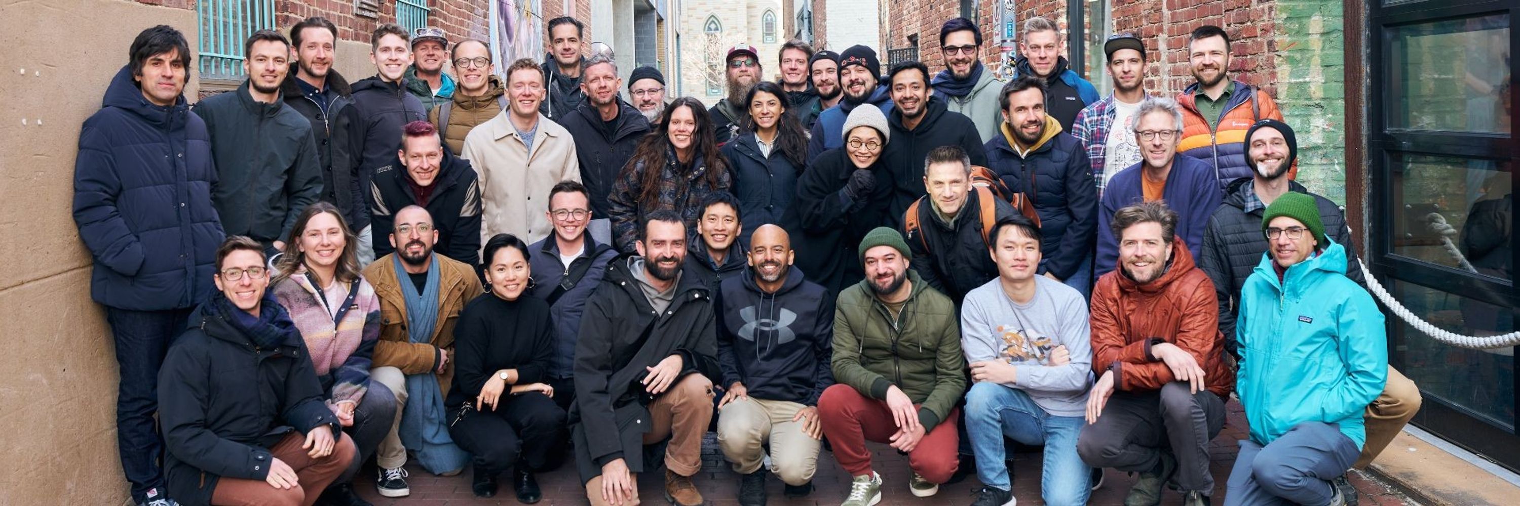
Had a great week spending time IRL with my @developmentseed.org team in Lisbon. I work with the smartest, kindest people and I’m feeling energized to finish the year strong and looking forward to 2026. 🫶


November 17, 2025 at 1:22 AM
Had a great week spending time IRL with my @developmentseed.org team in Lisbon. I work with the smartest, kindest people and I’m feeling energized to finish the year strong and looking forward to 2026. 🫶
Reposted by Development Seed
Bom dia!
📍DevSeed Lisbon
📍DevSeed Lisbon
November 10, 2025 at 1:10 PM
Bom dia!
📍DevSeed Lisbon
📍DevSeed Lisbon
We’re heading to Auckland 🇳🇿 for @foss4g2025.bsky.social to talk Rust 🦀 + open geospatial.
Catch our team showing how modern tools make geospatial faster and more interoperable.
Find us for zines + join the GeoRust sprint.
Get the deets: developmentseed.org/blog/2025-10...
#foss4g #osgeo
Catch our team showing how modern tools make geospatial faster and more interoperable.
Find us for zines + join the GeoRust sprint.
Get the deets: developmentseed.org/blog/2025-10...
#foss4g #osgeo

November 7, 2025 at 3:14 PM
We’re heading to Auckland 🇳🇿 for @foss4g2025.bsky.social to talk Rust 🦀 + open geospatial.
Catch our team showing how modern tools make geospatial faster and more interoperable.
Find us for zines + join the GeoRust sprint.
Get the deets: developmentseed.org/blog/2025-10...
#foss4g #osgeo
Catch our team showing how modern tools make geospatial faster and more interoperable.
Find us for zines + join the GeoRust sprint.
Get the deets: developmentseed.org/blog/2025-10...
#foss4g #osgeo
Reposted by Development Seed

Slides for my @foss4gna.bsky.social NA talk, "Cloud-Native Geospatial Metadata with stac-geoparquet" are at www.gadom.ski/presentation...
I subtitled the talk "Practical STAC", because #stac-geoparquet was motivated by real-world problems found while managing large @stacspec.bsky.social systems
I subtitled the talk "Practical STAC", because #stac-geoparquet was motivated by real-world problems found while managing large @stacspec.bsky.social systems
stac-geoparquet
www.gadom.ski
November 5, 2025 at 10:44 AM
Slides for my @foss4gna.bsky.social NA talk, "Cloud-Native Geospatial Metadata with stac-geoparquet" are at www.gadom.ski/presentation...
I subtitled the talk "Practical STAC", because #stac-geoparquet was motivated by real-world problems found while managing large @stacspec.bsky.social systems
I subtitled the talk "Practical STAC", because #stac-geoparquet was motivated by real-world problems found while managing large @stacspec.bsky.social systems
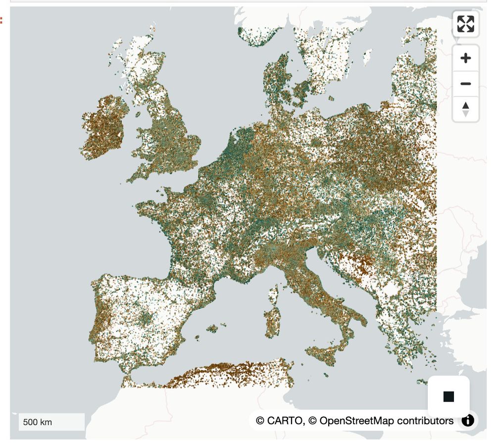
We took Canada’s Spatial Access Measures dataset (big, clunky CSVs) → turned it into a single GeoParquet file.
Add DuckDB-WASM + deck.gl & you get
- instant queries
- smooth maps
- no backend
Public data, but actually usable.
developmentseed.org/blog/2025-10...
@saadiqmohiuddin.bsky.social
Add DuckDB-WASM + deck.gl & you get
- instant queries
- smooth maps
- no backend
Public data, but actually usable.
developmentseed.org/blog/2025-10...
@saadiqmohiuddin.bsky.social
November 6, 2025 at 6:38 PM
We took Canada’s Spatial Access Measures dataset (big, clunky CSVs) → turned it into a single GeoParquet file.
Add DuckDB-WASM + deck.gl & you get
- instant queries
- smooth maps
- no backend
Public data, but actually usable.
developmentseed.org/blog/2025-10...
@saadiqmohiuddin.bsky.social
Add DuckDB-WASM + deck.gl & you get
- instant queries
- smooth maps
- no backend
Public data, but actually usable.
developmentseed.org/blog/2025-10...
@saadiqmohiuddin.bsky.social
Reposted by Development Seed
New blog post! kylebarron.dev/blog/fast-py...
This dives into performance pitfalls of Python bindings, why projects like Lonboard are so fast, and why I care about Apache Arrow so much. The post is high level and you don't need to know C/C++/Rust to understand it!
This dives into performance pitfalls of Python bindings, why projects like Lonboard are so fast, and why I care about Apache Arrow so much. The post is high level and you don't need to know C/C++/Rust to understand it!

October 7, 2025 at 2:05 PM
New blog post! kylebarron.dev/blog/fast-py...
This dives into performance pitfalls of Python bindings, why projects like Lonboard are so fast, and why I care about Apache Arrow so much. The post is high level and you don't need to know C/C++/Rust to understand it!
This dives into performance pitfalls of Python bindings, why projects like Lonboard are so fast, and why I care about Apache Arrow so much. The post is high level and you don't need to know C/C++/Rust to understand it!
Reposted by Development Seed
I'm happy to announce I've been promoted to an Apache Arrow Committer, meaning I'm authorized to merge code patches into Arrow repositories!
I join this list of amazing people: arrow.apache.org/committers/
I join this list of amazing people: arrow.apache.org/committers/

Committers
List of project-management committee (PMC) members and committers on the Apache Arrow project.
arrow.apache.org
October 9, 2025 at 6:31 PM
I'm happy to announce I've been promoted to an Apache Arrow Committer, meaning I'm authorized to merge code patches into Arrow repositories!
I join this list of amazing people: arrow.apache.org/committers/
I join this list of amazing people: arrow.apache.org/committers/
Reposted by Development Seed
Released Lonboard v0.13!
- New layer types: H3, S2, Geohash, A5 and fixed HeatmapLayer
- Render data layers beneath Maplibre text labels
- Map UI controls: scale, fullscreen, navigation
- Significant performance improvements: fixing earlier regressions
developmentseed.org/lonboard/lat...
- New layer types: H3, S2, Geohash, A5 and fixed HeatmapLayer
- Render data layers beneath Maplibre text labels
- Map UI controls: scale, fullscreen, navigation
- Significant performance improvements: fixing earlier regressions
developmentseed.org/lonboard/lat...


November 5, 2025 at 9:26 PM
Released Lonboard v0.13!
- New layer types: H3, S2, Geohash, A5 and fixed HeatmapLayer
- Render data layers beneath Maplibre text labels
- Map UI controls: scale, fullscreen, navigation
- Significant performance improvements: fixing earlier regressions
developmentseed.org/lonboard/lat...
- New layer types: H3, S2, Geohash, A5 and fixed HeatmapLayer
- Render data layers beneath Maplibre text labels
- Map UI controls: scale, fullscreen, navigation
- Significant performance improvements: fixing earlier regressions
developmentseed.org/lonboard/lat...
Reposted by Development Seed

latest out from our lab- led by Saurabh Kaushik- we find at least one geofoundational model (just testing Privthi here) is outperforming CNNs and transformers for mapping glaciers (esp. termini and snouts). we released a dataset with >1800 global images with it too! doi.org/10.1016/j.sr...
Redirecting
doi.org
November 4, 2025 at 4:19 AM
latest out from our lab- led by Saurabh Kaushik- we find at least one geofoundational model (just testing Privthi here) is outperforming CNNs and transformers for mapping glaciers (esp. termini and snouts). we released a dataset with >1800 global images with it too! doi.org/10.1016/j.sr...

We’re hiring a Cloud Engineer (EU/UK) 🌍
Help build open-source, cloud-native geospatial + AI tools with partners like ESA, NASA & ECMWF.
Remote-first from an ESA member state or join us in Lisbon.
grnh.se/9f2aodg43us
#hiring #jobs #geospatial #europe
Help build open-source, cloud-native geospatial + AI tools with partners like ESA, NASA & ECMWF.
Remote-first from an ESA member state or join us in Lisbon.
grnh.se/9f2aodg43us
#hiring #jobs #geospatial #europe

October 29, 2025 at 6:10 PM
We’re hiring a Cloud Engineer (EU/UK) 🌍
Help build open-source, cloud-native geospatial + AI tools with partners like ESA, NASA & ECMWF.
Remote-first from an ESA member state or join us in Lisbon.
grnh.se/9f2aodg43us
#hiring #jobs #geospatial #europe
Help build open-source, cloud-native geospatial + AI tools with partners like ESA, NASA & ECMWF.
Remote-first from an ESA member state or join us in Lisbon.
grnh.se/9f2aodg43us
#hiring #jobs #geospatial #europe
See you at @foss4gna.bsky.social in Reston next week!
We’re sharing:
• eoAPI for humanitarian maps
• stac-geoparquet + stac-map
• VirtualiZarr
• an eoAPI workshop (still time to sign up!)
👋 Grab a zine and say hi
developmentseed.org/blog/2025-10...
We’re sharing:
• eoAPI for humanitarian maps
• stac-geoparquet + stac-map
• VirtualiZarr
• an eoAPI workshop (still time to sign up!)
👋 Grab a zine and say hi
developmentseed.org/blog/2025-10...

October 29, 2025 at 5:06 PM
See you at @foss4gna.bsky.social in Reston next week!
We’re sharing:
• eoAPI for humanitarian maps
• stac-geoparquet + stac-map
• VirtualiZarr
• an eoAPI workshop (still time to sign up!)
👋 Grab a zine and say hi
developmentseed.org/blog/2025-10...
We’re sharing:
• eoAPI for humanitarian maps
• stac-geoparquet + stac-map
• VirtualiZarr
• an eoAPI workshop (still time to sign up!)
👋 Grab a zine and say hi
developmentseed.org/blog/2025-10...
Reposted by Development Seed
#foss4g-na is next week! I'll be talking Tuesday about #stac-geoparquet and running a workshop Monday with @wildintellect.com on #eoAPI. Quite a few of my @developmentseed.org colleagues will be there as well!
Stop by, say hi, and let's have a chat!
Stop by, say hi, and let's have a chat!


October 28, 2025 at 9:45 PM
#foss4g-na is next week! I'll be talking Tuesday about #stac-geoparquet and running a workshop Monday with @wildintellect.com on #eoAPI. Quite a few of my @developmentseed.org colleagues will be there as well!
Stop by, say hi, and let's have a chat!
Stop by, say hi, and let's have a chat!