


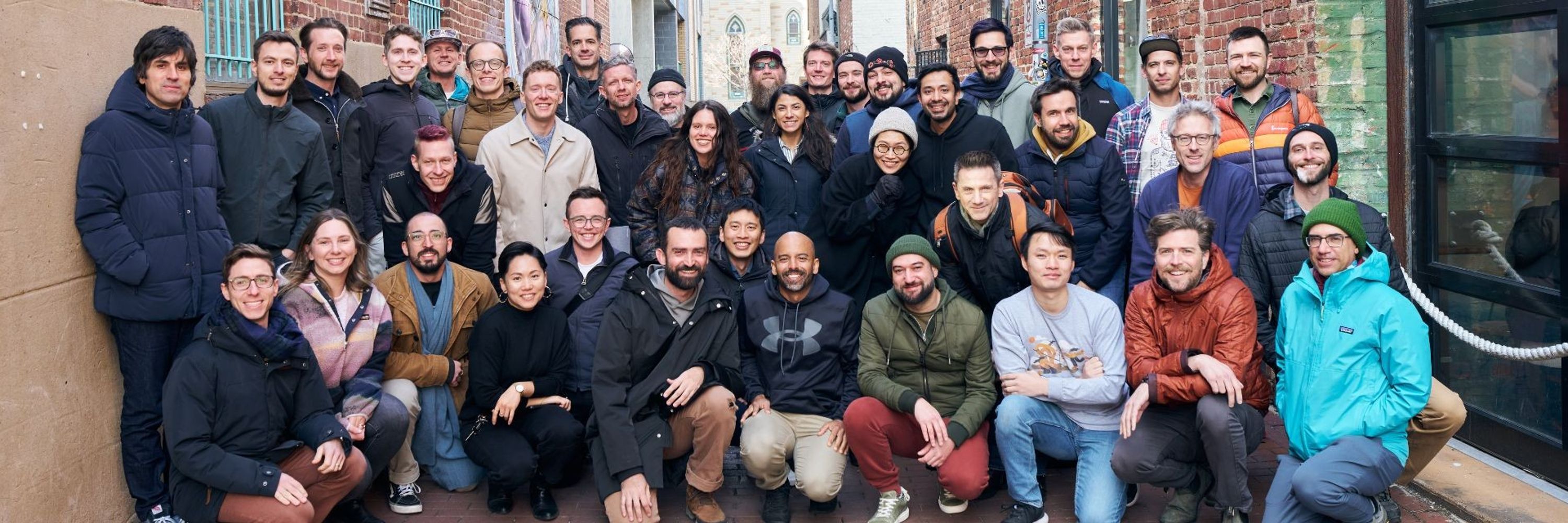

Pinned
Development Seed
@developmentseed.org
· Oct 29
We made a Starter Pack of all our team members on Bluesky. Give them a follow to hear about the cool things they are working on.
go.bsky.app/Rgbegts
go.bsky.app/Rgbegts
Reposted by Development Seed

Bom dia!
📍DevSeed Lisbon
📍DevSeed Lisbon

November 10, 2025 at 1:10 PM
Bom dia!
📍DevSeed Lisbon
📍DevSeed Lisbon
We’re heading to Auckland 🇳🇿 for @foss4g2025.bsky.social to talk Rust 🦀 + open geospatial.
Catch our team showing how modern tools make geospatial faster and more interoperable.
Find us for zines + join the GeoRust sprint.
Get the deets: developmentseed.org/blog/2025-10...
#foss4g #osgeo
Catch our team showing how modern tools make geospatial faster and more interoperable.
Find us for zines + join the GeoRust sprint.
Get the deets: developmentseed.org/blog/2025-10...
#foss4g #osgeo

November 7, 2025 at 3:14 PM
We’re heading to Auckland 🇳🇿 for @foss4g2025.bsky.social to talk Rust 🦀 + open geospatial.
Catch our team showing how modern tools make geospatial faster and more interoperable.
Find us for zines + join the GeoRust sprint.
Get the deets: developmentseed.org/blog/2025-10...
#foss4g #osgeo
Catch our team showing how modern tools make geospatial faster and more interoperable.
Find us for zines + join the GeoRust sprint.
Get the deets: developmentseed.org/blog/2025-10...
#foss4g #osgeo
Reposted by Development Seed

Slides for my @foss4gna.bsky.social NA talk, "Cloud-Native Geospatial Metadata with stac-geoparquet" are at www.gadom.ski/presentation...
I subtitled the talk "Practical STAC", because #stac-geoparquet was motivated by real-world problems found while managing large @stacspec.bsky.social systems
I subtitled the talk "Practical STAC", because #stac-geoparquet was motivated by real-world problems found while managing large @stacspec.bsky.social systems
stac-geoparquet
www.gadom.ski
November 5, 2025 at 10:44 AM
Slides for my @foss4gna.bsky.social NA talk, "Cloud-Native Geospatial Metadata with stac-geoparquet" are at www.gadom.ski/presentation...
I subtitled the talk "Practical STAC", because #stac-geoparquet was motivated by real-world problems found while managing large @stacspec.bsky.social systems
I subtitled the talk "Practical STAC", because #stac-geoparquet was motivated by real-world problems found while managing large @stacspec.bsky.social systems
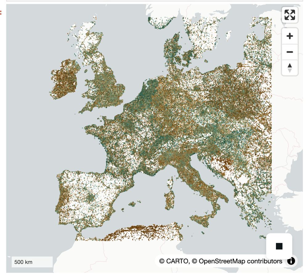
We took Canada’s Spatial Access Measures dataset (big, clunky CSVs) → turned it into a single GeoParquet file.
Add DuckDB-WASM + deck.gl & you get
- instant queries
- smooth maps
- no backend
Public data, but actually usable.
developmentseed.org/blog/2025-10...
@saadiqmohiuddin.bsky.social
Add DuckDB-WASM + deck.gl & you get
- instant queries
- smooth maps
- no backend
Public data, but actually usable.
developmentseed.org/blog/2025-10...
@saadiqmohiuddin.bsky.social
November 6, 2025 at 6:38 PM
We took Canada’s Spatial Access Measures dataset (big, clunky CSVs) → turned it into a single GeoParquet file.
Add DuckDB-WASM + deck.gl & you get
- instant queries
- smooth maps
- no backend
Public data, but actually usable.
developmentseed.org/blog/2025-10...
@saadiqmohiuddin.bsky.social
Add DuckDB-WASM + deck.gl & you get
- instant queries
- smooth maps
- no backend
Public data, but actually usable.
developmentseed.org/blog/2025-10...
@saadiqmohiuddin.bsky.social
Reposted by Development Seed

New blog post! kylebarron.dev/blog/fast-py...
This dives into performance pitfalls of Python bindings, why projects like Lonboard are so fast, and why I care about Apache Arrow so much. The post is high level and you don't need to know C/C++/Rust to understand it!
This dives into performance pitfalls of Python bindings, why projects like Lonboard are so fast, and why I care about Apache Arrow so much. The post is high level and you don't need to know C/C++/Rust to understand it!

October 7, 2025 at 2:05 PM
New blog post! kylebarron.dev/blog/fast-py...
This dives into performance pitfalls of Python bindings, why projects like Lonboard are so fast, and why I care about Apache Arrow so much. The post is high level and you don't need to know C/C++/Rust to understand it!
This dives into performance pitfalls of Python bindings, why projects like Lonboard are so fast, and why I care about Apache Arrow so much. The post is high level and you don't need to know C/C++/Rust to understand it!
Reposted by Development Seed
I'm happy to announce I've been promoted to an Apache Arrow Committer, meaning I'm authorized to merge code patches into Arrow repositories!
I join this list of amazing people: arrow.apache.org/committers/
I join this list of amazing people: arrow.apache.org/committers/

Committers
List of project-management committee (PMC) members and committers on the Apache Arrow project.
arrow.apache.org
October 9, 2025 at 6:31 PM
I'm happy to announce I've been promoted to an Apache Arrow Committer, meaning I'm authorized to merge code patches into Arrow repositories!
I join this list of amazing people: arrow.apache.org/committers/
I join this list of amazing people: arrow.apache.org/committers/
Reposted by Development Seed
Released Lonboard v0.13!
- New layer types: H3, S2, Geohash, A5 and fixed HeatmapLayer
- Render data layers beneath Maplibre text labels
- Map UI controls: scale, fullscreen, navigation
- Significant performance improvements: fixing earlier regressions
developmentseed.org/lonboard/lat...
- New layer types: H3, S2, Geohash, A5 and fixed HeatmapLayer
- Render data layers beneath Maplibre text labels
- Map UI controls: scale, fullscreen, navigation
- Significant performance improvements: fixing earlier regressions
developmentseed.org/lonboard/lat...


November 5, 2025 at 9:26 PM
Released Lonboard v0.13!
- New layer types: H3, S2, Geohash, A5 and fixed HeatmapLayer
- Render data layers beneath Maplibre text labels
- Map UI controls: scale, fullscreen, navigation
- Significant performance improvements: fixing earlier regressions
developmentseed.org/lonboard/lat...
- New layer types: H3, S2, Geohash, A5 and fixed HeatmapLayer
- Render data layers beneath Maplibre text labels
- Map UI controls: scale, fullscreen, navigation
- Significant performance improvements: fixing earlier regressions
developmentseed.org/lonboard/lat...
Reposted by Development Seed

latest out from our lab- led by Saurabh Kaushik- we find at least one geofoundational model (just testing Privthi here) is outperforming CNNs and transformers for mapping glaciers (esp. termini and snouts). we released a dataset with >1800 global images with it too! doi.org/10.1016/j.sr...
Redirecting
doi.org
November 4, 2025 at 4:19 AM
latest out from our lab- led by Saurabh Kaushik- we find at least one geofoundational model (just testing Privthi here) is outperforming CNNs and transformers for mapping glaciers (esp. termini and snouts). we released a dataset with >1800 global images with it too! doi.org/10.1016/j.sr...

We’re hiring a Cloud Engineer (EU/UK) 🌍
Help build open-source, cloud-native geospatial + AI tools with partners like ESA, NASA & ECMWF.
Remote-first from an ESA member state or join us in Lisbon.
grnh.se/9f2aodg43us
#hiring #jobs #geospatial #europe
Help build open-source, cloud-native geospatial + AI tools with partners like ESA, NASA & ECMWF.
Remote-first from an ESA member state or join us in Lisbon.
grnh.se/9f2aodg43us
#hiring #jobs #geospatial #europe

October 29, 2025 at 6:10 PM
We’re hiring a Cloud Engineer (EU/UK) 🌍
Help build open-source, cloud-native geospatial + AI tools with partners like ESA, NASA & ECMWF.
Remote-first from an ESA member state or join us in Lisbon.
grnh.se/9f2aodg43us
#hiring #jobs #geospatial #europe
Help build open-source, cloud-native geospatial + AI tools with partners like ESA, NASA & ECMWF.
Remote-first from an ESA member state or join us in Lisbon.
grnh.se/9f2aodg43us
#hiring #jobs #geospatial #europe
See you at @foss4gna.bsky.social in Reston next week!
We’re sharing:
• eoAPI for humanitarian maps
• stac-geoparquet + stac-map
• VirtualiZarr
• an eoAPI workshop (still time to sign up!)
👋 Grab a zine and say hi
developmentseed.org/blog/2025-10...
We’re sharing:
• eoAPI for humanitarian maps
• stac-geoparquet + stac-map
• VirtualiZarr
• an eoAPI workshop (still time to sign up!)
👋 Grab a zine and say hi
developmentseed.org/blog/2025-10...

October 29, 2025 at 5:06 PM
See you at @foss4gna.bsky.social in Reston next week!
We’re sharing:
• eoAPI for humanitarian maps
• stac-geoparquet + stac-map
• VirtualiZarr
• an eoAPI workshop (still time to sign up!)
👋 Grab a zine and say hi
developmentseed.org/blog/2025-10...
We’re sharing:
• eoAPI for humanitarian maps
• stac-geoparquet + stac-map
• VirtualiZarr
• an eoAPI workshop (still time to sign up!)
👋 Grab a zine and say hi
developmentseed.org/blog/2025-10...
Reposted by Development Seed
#foss4g-na is next week! I'll be talking Tuesday about #stac-geoparquet and running a workshop Monday with @wildintellect.com on #eoAPI. Quite a few of my @developmentseed.org colleagues will be there as well!
Stop by, say hi, and let's have a chat!
Stop by, say hi, and let's have a chat!


October 28, 2025 at 9:45 PM
#foss4g-na is next week! I'll be talking Tuesday about #stac-geoparquet and running a workshop Monday with @wildintellect.com on #eoAPI. Quite a few of my @developmentseed.org colleagues will be there as well!
Stop by, say hi, and let's have a chat!
Stop by, say hi, and let's have a chat!
Reposted by Development Seed
Curious about the new #Zarr data format for #Sentinel data? Want to ask experts from @developmentseed.org and thriveGEO how to use it?
Join our Office Hours session on Nov 4, 10-11am (UTC+1):
⭐ buytickets.at/thrivegeo/19...
Everyone is welcome!
Join our Office Hours session on Nov 4, 10-11am (UTC+1):
⭐ buytickets.at/thrivegeo/19...
Everyone is welcome!
Select tickets – EOPF Zarr Community Notebook Competition - Office Hours 1 – Google Meet
EOPF Zarr Community Notebook Competition - Office Hours 1 – Google Meet, Tue 4 Nov 2025 - Welcome to the EOPF
Toolkit Community Notebook Competition! We're inviting Sentinel data
users and developer...
buytickets.at
October 27, 2025 at 1:16 PM
Curious about the new #Zarr data format for #Sentinel data? Want to ask experts from @developmentseed.org and thriveGEO how to use it?
Join our Office Hours session on Nov 4, 10-11am (UTC+1):
⭐ buytickets.at/thrivegeo/19...
Everyone is welcome!
Join our Office Hours session on Nov 4, 10-11am (UTC+1):
⭐ buytickets.at/thrivegeo/19...
Everyone is welcome!
Reposted by Development Seed

#duckdb and #deckgl have come a long way, amazing what can be done directly in the browser @developmentseed.org developmentseed.org/spatial-acce...

October 18, 2025 at 9:31 PM
#duckdb and #deckgl have come a long way, amazing what can be done directly in the browser @developmentseed.org developmentseed.org/spatial-acce...
DevSeed intern Beatriz Peres used ESA’s new Sentinel-1 Zarr to analyze the 2024 Valencia floods with lightweight, time-series workflows.
Her blog shows how Zarr + xarray make flood monitoring faster & more flexible: developmentseed.org/blog/2025-09...
#BiDS25 @thrivegeo.bsky.social
Her blog shows how Zarr + xarray make flood monitoring faster & more flexible: developmentseed.org/blog/2025-09...
#BiDS25 @thrivegeo.bsky.social

October 1, 2025 at 7:11 PM
DevSeed intern Beatriz Peres used ESA’s new Sentinel-1 Zarr to analyze the 2024 Valencia floods with lightweight, time-series workflows.
Her blog shows how Zarr + xarray make flood monitoring faster & more flexible: developmentseed.org/blog/2025-09...
#BiDS25 @thrivegeo.bsky.social
Her blog shows how Zarr + xarray make flood monitoring faster & more flexible: developmentseed.org/blog/2025-09...
#BiDS25 @thrivegeo.bsky.social
At #BiDS2025 this week!
At two demos we're sharing how to make Sentinel data more accessible and actionable:
🔹 Sentinel Zarr Explorer
🔹 EOPF Toolkit + Notebook Competition with @thrivegeo.bsky.social
Agenda: bids25-signup.esa.int/agenda
We'd love to chat!
#EarthObservation #BigData #CloudNative
At two demos we're sharing how to make Sentinel data more accessible and actionable:
🔹 Sentinel Zarr Explorer
🔹 EOPF Toolkit + Notebook Competition with @thrivegeo.bsky.social
Agenda: bids25-signup.esa.int/agenda
We'd love to chat!
#EarthObservation #BigData #CloudNative

September 29, 2025 at 6:17 PM
At #BiDS2025 this week!
At two demos we're sharing how to make Sentinel data more accessible and actionable:
🔹 Sentinel Zarr Explorer
🔹 EOPF Toolkit + Notebook Competition with @thrivegeo.bsky.social
Agenda: bids25-signup.esa.int/agenda
We'd love to chat!
#EarthObservation #BigData #CloudNative
At two demos we're sharing how to make Sentinel data more accessible and actionable:
🔹 Sentinel Zarr Explorer
🔹 EOPF Toolkit + Notebook Competition with @thrivegeo.bsky.social
Agenda: bids25-signup.esa.int/agenda
We'd love to chat!
#EarthObservation #BigData #CloudNative
A big group of us is headed to SatCamp this week to hike, bike & scheme with an amazing community of EO enthusiasts & experts. Will we see you there?
September 22, 2025 at 11:23 PM
A big group of us is headed to SatCamp this week to hike, bike & scheme with an amazing community of EO enthusiasts & experts. Will we see you there?
Reposted by Development Seed

🪐 We believe that foundational planetary data should be open and accessible to all. Thanks to @source.coop Cooperative, we’re able to share our datasets with the broader open data community.
docs.source.coop/case-studies...
docs.source.coop/case-studies...

Earth Genome | Source Cooperative Documentation
Earth Genome Datasets on Source
docs.source.coop
September 18, 2025 at 6:37 PM
🪐 We believe that foundational planetary data should be open and accessible to all. Thanks to @source.coop Cooperative, we’re able to share our datasets with the broader open data community.
docs.source.coop/case-studies...
docs.source.coop/case-studies...
Reposted by Development Seed
Lonboard's 0.12 release improved the support for GeoArrow data types, and is moving towards being fully GeoArrow-native. Shapely is no longer a required dependency!
github.com/developments...
github.com/developments...

Release v0.12.0 · developmentseed/lonboard
New Features ✨
feat: Add new example notebook on accessing spatially-partitioned Overture GeoParquet datasets by @kylebarron in #832
feat: Allow passing GeoArrow arrays and chunked arrays directly...
github.com
September 18, 2025 at 8:07 PM
Lonboard's 0.12 release improved the support for GeoArrow data types, and is moving towards being fully GeoArrow-native. Shapely is no longer a required dependency!
github.com/developments...
github.com/developments...
Reposted by Development Seed
New Lonboard release and new demo! Integrating marimo and Apache DataFusion to visualize the NYC taxi dataset. developmentseed.org/lonboard/lat...
September 18, 2025 at 8:02 PM
New Lonboard release and new demo! Integrating marimo and Apache DataFusion to visualize the NYC taxi dataset. developmentseed.org/lonboard/lat...
@worldresources.bsky.social call to move past the hype and use AI responsibly for public good resonates with how we've approached AI in our work. This is the conversation to pay attention to — don’t miss the livestream this week.
Sign up: landcarbonlab.org/events/ai-me...
Sign up: landcarbonlab.org/events/ai-me...

September 15, 2025 at 8:57 PM
@worldresources.bsky.social call to move past the hype and use AI responsibly for public good resonates with how we've approached AI in our work. This is the conversation to pay attention to — don’t miss the livestream this week.
Sign up: landcarbonlab.org/events/ai-me...
Sign up: landcarbonlab.org/events/ai-me...
We're running another edition of our Foundation Models workshop. This time at EarthSense 2025.
attend.ieee.org/earthsense-2...
#ai #geoai #foundationmodels #remotesensing #earthsense2025
@sunu.bsky.social
attend.ieee.org/earthsense-2...
#ai #geoai #foundationmodels #remotesensing #earthsense2025
@sunu.bsky.social

September 15, 2025 at 3:41 PM
We're running another edition of our Foundation Models workshop. This time at EarthSense 2025.
attend.ieee.org/earthsense-2...
#ai #geoai #foundationmodels #remotesensing #earthsense2025
@sunu.bsky.social
attend.ieee.org/earthsense-2...
#ai #geoai #foundationmodels #remotesensing #earthsense2025
@sunu.bsky.social
We built stac-map, a lightweight, map-first prototype for exploring STAC GeoParquet in your browser. Built w/ DuckDB, geoarrow, & semantic STAC search, explore STAC GeoParquet files directly in the browser.
Try it: developmentseed.org/stac-map/
Blog: ds.io/stac-map
@gadom.ski @indraneel.org
Try it: developmentseed.org/stac-map/
Blog: ds.io/stac-map
@gadom.ski @indraneel.org
September 9, 2025 at 6:55 PM
We built stac-map, a lightweight, map-first prototype for exploring STAC GeoParquet in your browser. Built w/ DuckDB, geoarrow, & semantic STAC search, explore STAC GeoParquet files directly in the browser.
Try it: developmentseed.org/stac-map/
Blog: ds.io/stac-map
@gadom.ski @indraneel.org
Try it: developmentseed.org/stac-map/
Blog: ds.io/stac-map
@gadom.ski @indraneel.org
Reposted by Development Seed
Blog post up for stac-map: developmentseed.org/blog/2025-09...
A very imperfect prototype of a map-first #STAC app, it includes:
- stac-geoparquet visualization and download
- Experimental natural language collection search
Uses #deck.gl, @duckdb.org, #geoarrow, and github.com/stac-utils/r...
A very imperfect prototype of a map-first #STAC app, it includes:
- stac-geoparquet visualization and download
- Experimental natural language collection search
Uses #deck.gl, @duckdb.org, #geoarrow, and github.com/stac-utils/r...

A Map-First Tool for Exploring STAC Data — Development Seed
stac-map makes exploring STAC GeoParquet as simple as zooming around a map.
developmentseed.org
September 4, 2025 at 4:19 PM
Blog post up for stac-map: developmentseed.org/blog/2025-09...
A very imperfect prototype of a map-first #STAC app, it includes:
- stac-geoparquet visualization and download
- Experimental natural language collection search
Uses #deck.gl, @duckdb.org, #geoarrow, and github.com/stac-utils/r...
A very imperfect prototype of a map-first #STAC app, it includes:
- stac-geoparquet visualization and download
- Experimental natural language collection search
Uses #deck.gl, @duckdb.org, #geoarrow, and github.com/stac-utils/r...
Reposted by Development Seed
It’s Friday and I’m in car line at my kids school. It’s only 98 degrees today.
I’ll share this from the DevSeed account next week but @zacdezgeo.github.io & I just wrapped the blog on building QGIS plugins and what we learned from updating the GEE-QGIS plugin.
developmentseed.org/blog/2025-08...
I’ll share this from the DevSeed account next week but @zacdezgeo.github.io & I just wrapped the blog on building QGIS plugins and what we learned from updating the GEE-QGIS plugin.
developmentseed.org/blog/2025-08...

Better QGIS Plugins — Development Seed
Build better QGIS plugins with custom dialogs and the Processing framework.
developmentseed.org
August 15, 2025 at 9:53 PM
It’s Friday and I’m in car line at my kids school. It’s only 98 degrees today.
I’ll share this from the DevSeed account next week but @zacdezgeo.github.io & I just wrapped the blog on building QGIS plugins and what we learned from updating the GEE-QGIS plugin.
developmentseed.org/blog/2025-08...
I’ll share this from the DevSeed account next week but @zacdezgeo.github.io & I just wrapped the blog on building QGIS plugins and what we learned from updating the GEE-QGIS plugin.
developmentseed.org/blog/2025-08...