


Michael Fischer
@mikefischerwx.bsky.social
Assistant Professor at the University of Miami. Usually discussing hurricanes.
Unfortunately the sky was indeed the limit. Catastrophic #Melissa is on track to be the strongest hurricane to make landfall in the Atlantic in 90 years. Just absolutely gutted for the souls in Jamaica.


October 28, 2025 at 2:35 PM
Unfortunately the sky was indeed the limit. Catastrophic #Melissa is on track to be the strongest hurricane to make landfall in the Atlantic in 90 years. Just absolutely gutted for the souls in Jamaica.
#Melissa is intensifying very rapidly this evening. TDR structure is nearly perfect for a TC of this intensity. Incredibly symmetric, strong eyewall, and a deep, aligned circulation. The sky is the limit. Very scary situation.


October 26, 2025 at 12:03 AM
#Melissa is intensifying very rapidly this evening. TDR structure is nearly perfect for a TC of this intensity. Incredibly symmetric, strong eyewall, and a deep, aligned circulation. The sky is the limit. Very scary situation.

#Melissa is about to undergo rapid intensification (RI). And I anticipate it will be quite explosive. A classic cyan ring on 37 GHz imagery from this GMI overpass at 1447 UTC.

October 25, 2025 at 4:15 PM
#Melissa is about to undergo rapid intensification (RI). And I anticipate it will be quite explosive. A classic cyan ring on 37 GHz imagery from this GMI overpass at 1447 UTC.
Two tropical cyclones churning in the western Atlantic. Here in FL, it’s business as usual. The power of modern meteorology.
September 29, 2025 at 12:27 PM
Two tropical cyclones churning in the western Atlantic. Here in FL, it’s business as usual. The power of modern meteorology.
This is one of the best satellite signatures I have ever seen in the SW Atlantic (non-Gulf/Caribbean). #Humberto is up there with storms like Andrew, Dorian, and Irma in my eyes.
September 27, 2025 at 5:33 PM
This is one of the best satellite signatures I have ever seen in the SW Atlantic (non-Gulf/Caribbean). #Humberto is up there with storms like Andrew, Dorian, and Irma in my eyes.
Update: Hurricane #Humberto has intensified 55 kt in the last 12 h… extreme RI ongoing. Anomalous upshear convection is again a tell for subsequent RI. Thankfully the storm is well away from land for now.

September 27, 2025 at 1:41 AM
Update: Hurricane #Humberto has intensified 55 kt in the last 12 h… extreme RI ongoing. Anomalous upshear convection is again a tell for subsequent RI. Thankfully the storm is well away from land for now.
Anomalous upshear convection is often associated with rapid intensification in hurricanes. Here is a schematic from my dissertation and a recent snapshot of Hurricane Humberto, which is experiencing westerly shear. Although Humberto is fairly compact, its structure suggests RI is ongoing.


September 26, 2025 at 1:07 PM
Anomalous upshear convection is often associated with rapid intensification in hurricanes. Here is a schematic from my dissertation and a recent snapshot of Hurricane Humberto, which is experiencing westerly shear. Although Humberto is fairly compact, its structure suggests RI is ongoing.


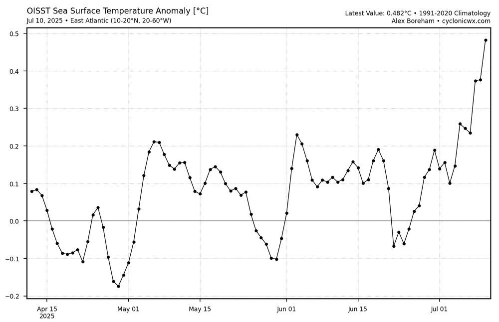
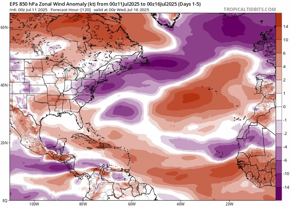
With anomalously weak trade winds, the eastern Main Development Region of the Atlantic has rapidly warmed over the last two weeks. Models suggest this flow pattern should largely continue, favoring additional warming.
July 11, 2025 at 2:42 PM
With anomalously weak trade winds, the eastern Main Development Region of the Atlantic has rapidly warmed over the last two weeks. Models suggest this flow pattern should largely continue, favoring additional warming.
Reposted by Michael Fischer

As of 6am CST 18 June #Erick is now a #hurricane & is likely starting rapid intensification, #RI, as a central dense overcast, #CDO, forms over the center.
Hurricane warnings in effect for coastal #Mexico from Acapulco to Puerto Angel & Erick forecast to be near major hurricane at landfall.
Hurricane warnings in effect for coastal #Mexico from Acapulco to Puerto Angel & Erick forecast to be near major hurricane at landfall.
June 18, 2025 at 12:00 PM
As of 6am CST 18 June #Erick is now a #hurricane & is likely starting rapid intensification, #RI, as a central dense overcast, #CDO, forms over the center.
Hurricane warnings in effect for coastal #Mexico from Acapulco to Puerto Angel & Erick forecast to be near major hurricane at landfall.
Hurricane warnings in effect for coastal #Mexico from Acapulco to Puerto Angel & Erick forecast to be near major hurricane at landfall.
Reposted by Michael Fischer

The 2026 budget passback plan calls for eliminating NOAA Research, the scientific backbone that keeps weather forecasts, alerts, and warnings accurate and effective. This would have disastrous consequences.
Read the AMS statement, in partnership w/ @nwas.org: bit.ly/4cz2RtC
Read the AMS statement, in partnership w/ @nwas.org: bit.ly/4cz2RtC
Stand Up for NOAA Research – The Time to Act is Now
The AMS is a global community committed to advancing weather, water, and climate science and service.
bit.ly
April 17, 2025 at 6:42 PM
The 2026 budget passback plan calls for eliminating NOAA Research, the scientific backbone that keeps weather forecasts, alerts, and warnings accurate and effective. This would have disastrous consequences.
Read the AMS statement, in partnership w/ @nwas.org: bit.ly/4cz2RtC
Read the AMS statement, in partnership w/ @nwas.org: bit.ly/4cz2RtC
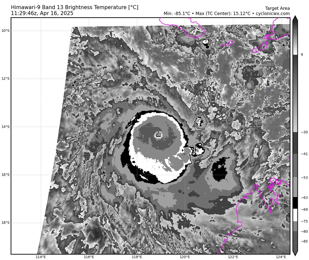
Cyclone Errol is an extremely powerful storm. IR brightness temps in the eye are quite warm for a core that small. Reminds me of Milton in the Atlantic last year. And for my northern hemisphere friends, I have rotated the IR pattern to be consistent with a positive Coriolis value in the 2nd image.
April 16, 2025 at 12:02 PM
Cyclone Errol is an extremely powerful storm. IR brightness temps in the eye are quite warm for a core that small. Reminds me of Milton in the Atlantic last year. And for my northern hemisphere friends, I have rotated the IR pattern to be consistent with a positive Coriolis value in the 2nd image.
Reposted by Michael Fischer

68,845,865.
That's how many individuals in the United States speak a language other than English at home.
Everyone deserves a chance to stay safe during disasters, and I will never stop advocating for that. Thinking of all the communities that are going to be affected by this change.
That's how many individuals in the United States speak a language other than English at home.
Everyone deserves a chance to stay safe during disasters, and I will never stop advocating for that. Thinking of all the communities that are going to be affected by this change.

The National Weather Service will stop issuing forecasts + storm warnings in Spanish after a translation software contract lapsed at midnight Tuesday. Unclear when/if service will return.
Scoop with @weathersullivan.bsky.social (free link):
www.bloomberg.com/news/article...
Scoop with @weathersullivan.bsky.social (free link):
www.bloomberg.com/news/article...

US Weather Forecasts in Spanish to Vanish as Translations Expire
The US National Weather Service has allowed a contract with a foreign-language translation service to expire, creating a potential gap in local-language forecasting just as spring brings a higher risk...
www.bloomberg.com
April 1, 2025 at 9:53 PM
68,845,865.
That's how many individuals in the United States speak a language other than English at home.
Everyone deserves a chance to stay safe during disasters, and I will never stop advocating for that. Thinking of all the communities that are going to be affected by this change.
That's how many individuals in the United States speak a language other than English at home.
Everyone deserves a chance to stay safe during disasters, and I will never stop advocating for that. Thinking of all the communities that are going to be affected by this change.
Thank you to UAH for the opportunity and hospitality during my visit. I had a great time talking about hurricanes and machine learning with the folks there. And a special thanks to @tcblers.bsky.social for the invitation and a great time in Huntsville!

Exciting to have @mikefischerwx.bsky.social to share his hurricane research at the UAH AES seminar and BLM class. Students showed high interests in the TC-RADAR dataset and future AI applications of aircraft observations. An extended Q&A session is the testament. Way to go, Professor :)


March 28, 2025 at 1:47 PM
Thank you to UAH for the opportunity and hospitality during my visit. I had a great time talking about hurricanes and machine learning with the folks there. And a special thanks to @tcblers.bsky.social for the invitation and a great time in Huntsville!
Reposted by Michael Fischer

Here's my annual blog post about the NOAA National Hurricane Center's updated "cone of uncertainty". Hopefully there are some tidbits in there that are new to you! Atlantic hurricane season begins June 1 and ends November 30.
bmcnoldy.blogspot.com/2025/03/2025...
bmcnoldy.blogspot.com/2025/03/2025...
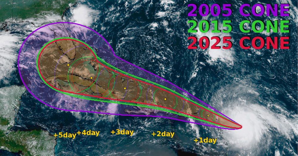
2025 "Cone of Uncertainty" Update & Refresher
Updates and summaries on tropical Atlantic activity... including easterly waves, tropical storms, subtropical storms, and hurricanes.
bmcnoldy.blogspot.com
March 7, 2025 at 8:47 PM
Here's my annual blog post about the NOAA National Hurricane Center's updated "cone of uncertainty". Hopefully there are some tidbits in there that are new to you! Atlantic hurricane season begins June 1 and ends November 30.
bmcnoldy.blogspot.com/2025/03/2025...
bmcnoldy.blogspot.com/2025/03/2025...
Reposted by Michael Fischer

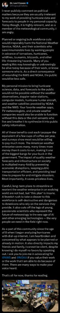
Probationary employees across @NOAA and the @NWS are being terminated today, including those in mission-essential roles.
My own wife is among them, essential to the Pacific Tsunami Warning Center's 24/7 critical mission of seismic monitoring and tsunami prediction to protect the public.
My own wife is among them, essential to the Pacific Tsunami Warning Center's 24/7 critical mission of seismic monitoring and tsunami prediction to protect the public.
February 27, 2025 at 10:10 PM
Probationary employees across @NOAA and the @NWS are being terminated today, including those in mission-essential roles.
My own wife is among them, essential to the Pacific Tsunami Warning Center's 24/7 critical mission of seismic monitoring and tsunami prediction to protect the public.
My own wife is among them, essential to the Pacific Tsunami Warning Center's 24/7 critical mission of seismic monitoring and tsunami prediction to protect the public.
Uh oh. Zelia is explosively intensifying at this point. The enclosed pink ring in 36 GHz imagery is typically a signal only seen in extremely intense TCs or those about to be extremely intense.

February 12, 2025 at 9:16 PM
Uh oh. Zelia is explosively intensifying at this point. The enclosed pink ring in 36 GHz imagery is typically a signal only seen in extremely intense TCs or those about to be extremely intense.
Off the northwest coast of Australia, Cyclone Zelia appears to be intensifying quite quickly. Some of the hurricane guidance brings the system up to the equivalent of category-5 intensity before landfall. Hopefully that’s overly aggressive.
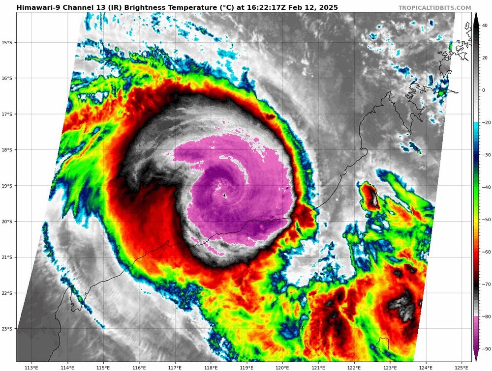
February 12, 2025 at 5:08 PM
Off the northwest coast of Australia, Cyclone Zelia appears to be intensifying quite quickly. Some of the hurricane guidance brings the system up to the equivalent of category-5 intensity before landfall. Hopefully that’s overly aggressive.
Just feel like I’m stuck in a nightmare that I’m not waking up from. What was egregious yesterday is tame today. When will it stop?
February 5, 2025 at 4:09 AM
Just feel like I’m stuck in a nightmare that I’m not waking up from. What was egregious yesterday is tame today. When will it stop?
"Are rapidly intensifying tropical cyclones associated with unique vortex and convective characteristics?" Well, you can find out more here: doi.org/10.1175/MWR-...
I'll summarize in the thread below.
I'll summarize in the thread below.
Are rapidly intensifying tropical cyclones associated with unique vortex and convective characteristics?
Abstract The largest tropical cyclone (TC) intensity forecast errors are typically associated with episodes of rapid intensification (RI). Here, we explore whether TCs that undergo RI are associated w...
doi.org
December 13, 2024 at 10:33 PM
"Are rapidly intensifying tropical cyclones associated with unique vortex and convective characteristics?" Well, you can find out more here: doi.org/10.1175/MWR-...
I'll summarize in the thread below.
I'll summarize in the thread below.
Xiaomin is an excellent scientist and friend of mine. If you’re interested in atmospheric science and grad school, here’s another great opportunity to explore.
🌀Our TCBL lab🌀is admitting a M.S. (or Ph.D.) student to study boundary layer winds and tornadoes of landfalling hurricanes from Fall 2025. Students with a strong passion for hurricane science and a strong background of programming/physics are particularly encouraged to apply. Welcome to spread out!


December 12, 2024 at 5:24 PM
Xiaomin is an excellent scientist and friend of mine. If you’re interested in atmospheric science and grad school, here’s another great opportunity to explore.
Reposted by Michael Fischer

The Philippines have now been hit by four typhoons in the span of just 10 days.
Can't say I recall ever seeing this before.
Can't say I recall ever seeing this before.
November 17, 2024 at 11:35 AM
The Philippines have now been hit by four typhoons in the span of just 10 days.
Can't say I recall ever seeing this before.
Can't say I recall ever seeing this before.
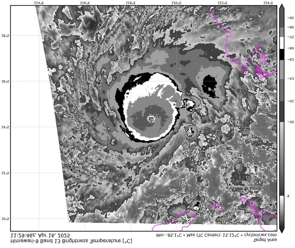
23C IR temp in the eye of Typhoon Man-Yi is very impressive! An extremely powerful typhoon approaching The Philippines.
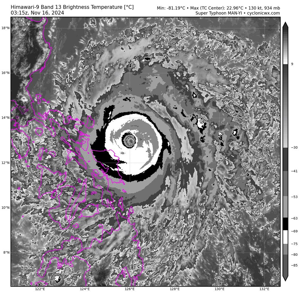
November 16, 2024 at 3:38 AM
23C IR temp in the eye of Typhoon Man-Yi is very impressive! An extremely powerful typhoon approaching The Philippines.