


Michael Fischer
@mikefischerwx.bsky.social
Assistant Professor at the University of Miami. Usually discussing hurricanes.
Unfortunately the sky was indeed the limit. Catastrophic #Melissa is on track to be the strongest hurricane to make landfall in the Atlantic in 90 years. Just absolutely gutted for the souls in Jamaica.


October 28, 2025 at 2:35 PM
Unfortunately the sky was indeed the limit. Catastrophic #Melissa is on track to be the strongest hurricane to make landfall in the Atlantic in 90 years. Just absolutely gutted for the souls in Jamaica.
#Melissa is intensifying very rapidly this evening. TDR structure is nearly perfect for a TC of this intensity. Incredibly symmetric, strong eyewall, and a deep, aligned circulation. The sky is the limit. Very scary situation.


October 26, 2025 at 12:03 AM
#Melissa is intensifying very rapidly this evening. TDR structure is nearly perfect for a TC of this intensity. Incredibly symmetric, strong eyewall, and a deep, aligned circulation. The sky is the limit. Very scary situation.

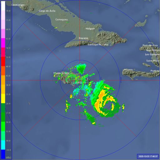
Ground-based radar imagery from Jamaica shows the core has continued to become better defined over the last six hours. A potentially catastrophic situation unfolding for Jamaica. #Melissa
October 25, 2025 at 6:01 PM
Ground-based radar imagery from Jamaica shows the core has continued to become better defined over the last six hours. A potentially catastrophic situation unfolding for Jamaica. #Melissa
#Melissa is about to undergo rapid intensification (RI). And I anticipate it will be quite explosive. A classic cyan ring on 37 GHz imagery from this GMI overpass at 1447 UTC.

October 25, 2025 at 4:15 PM
#Melissa is about to undergo rapid intensification (RI). And I anticipate it will be quite explosive. A classic cyan ring on 37 GHz imagery from this GMI overpass at 1447 UTC.
Two tropical cyclones churning in the western Atlantic. Here in FL, it’s business as usual. The power of modern meteorology.
September 29, 2025 at 12:27 PM
Two tropical cyclones churning in the western Atlantic. Here in FL, it’s business as usual. The power of modern meteorology.
This is one of the best satellite signatures I have ever seen in the SW Atlantic (non-Gulf/Caribbean). #Humberto is up there with storms like Andrew, Dorian, and Irma in my eyes.
September 27, 2025 at 5:33 PM
This is one of the best satellite signatures I have ever seen in the SW Atlantic (non-Gulf/Caribbean). #Humberto is up there with storms like Andrew, Dorian, and Irma in my eyes.
Update: Hurricane #Humberto has intensified 55 kt in the last 12 h… extreme RI ongoing. Anomalous upshear convection is again a tell for subsequent RI. Thankfully the storm is well away from land for now.

September 27, 2025 at 1:41 AM
Update: Hurricane #Humberto has intensified 55 kt in the last 12 h… extreme RI ongoing. Anomalous upshear convection is again a tell for subsequent RI. Thankfully the storm is well away from land for now.
Anomalous upshear convection is often associated with rapid intensification in hurricanes. Here is a schematic from my dissertation and a recent snapshot of Hurricane Humberto, which is experiencing westerly shear. Although Humberto is fairly compact, its structure suggests RI is ongoing.


September 26, 2025 at 1:07 PM
Anomalous upshear convection is often associated with rapid intensification in hurricanes. Here is a schematic from my dissertation and a recent snapshot of Hurricane Humberto, which is experiencing westerly shear. Although Humberto is fairly compact, its structure suggests RI is ongoing.


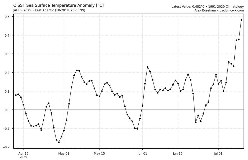
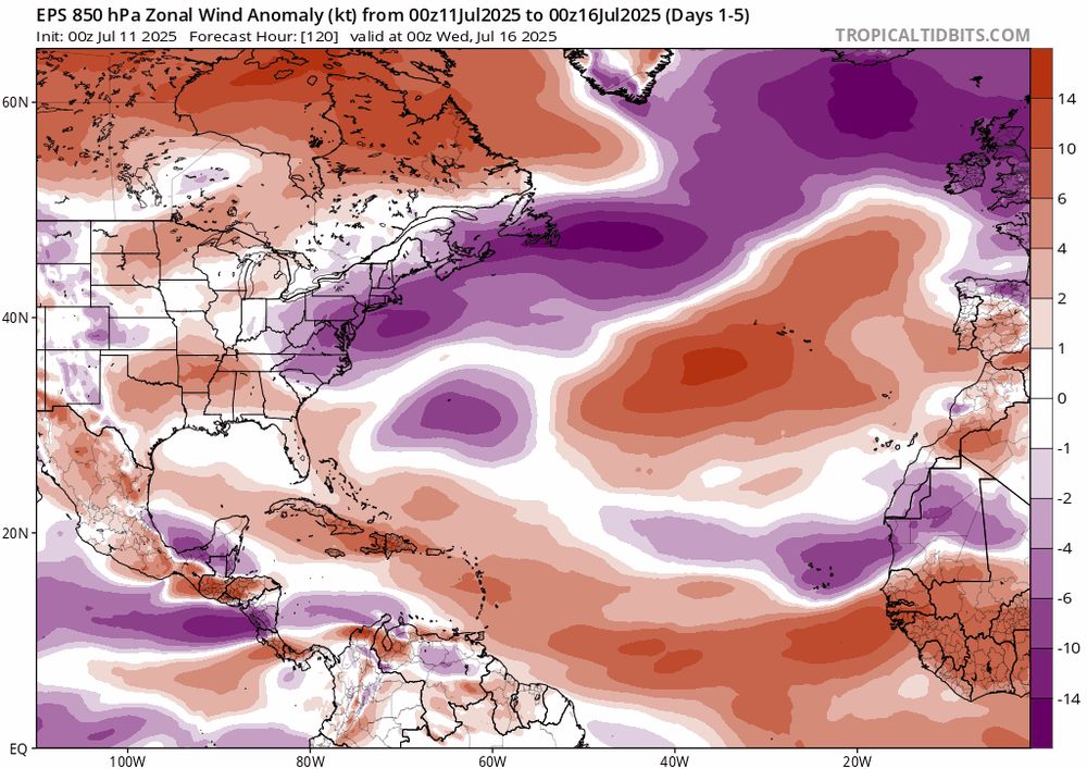
With anomalously weak trade winds, the eastern Main Development Region of the Atlantic has rapidly warmed over the last two weeks. Models suggest this flow pattern should largely continue, favoring additional warming.
July 11, 2025 at 2:42 PM
With anomalously weak trade winds, the eastern Main Development Region of the Atlantic has rapidly warmed over the last two weeks. Models suggest this flow pattern should largely continue, favoring additional warming.
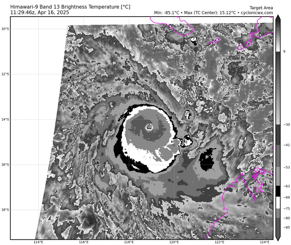
Cyclone Errol is an extremely powerful storm. IR brightness temps in the eye are quite warm for a core that small. Reminds me of Milton in the Atlantic last year. And for my northern hemisphere friends, I have rotated the IR pattern to be consistent with a positive Coriolis value in the 2nd image.
April 16, 2025 at 12:02 PM
Cyclone Errol is an extremely powerful storm. IR brightness temps in the eye are quite warm for a core that small. Reminds me of Milton in the Atlantic last year. And for my northern hemisphere friends, I have rotated the IR pattern to be consistent with a positive Coriolis value in the 2nd image.
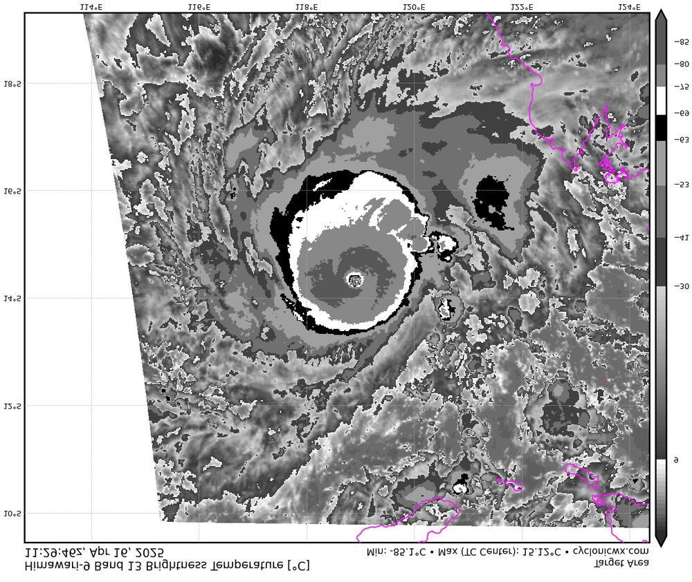
Uh oh. Zelia is explosively intensifying at this point. The enclosed pink ring in 36 GHz imagery is typically a signal only seen in extremely intense TCs or those about to be extremely intense.

February 12, 2025 at 9:16 PM
Uh oh. Zelia is explosively intensifying at this point. The enclosed pink ring in 36 GHz imagery is typically a signal only seen in extremely intense TCs or those about to be extremely intense.
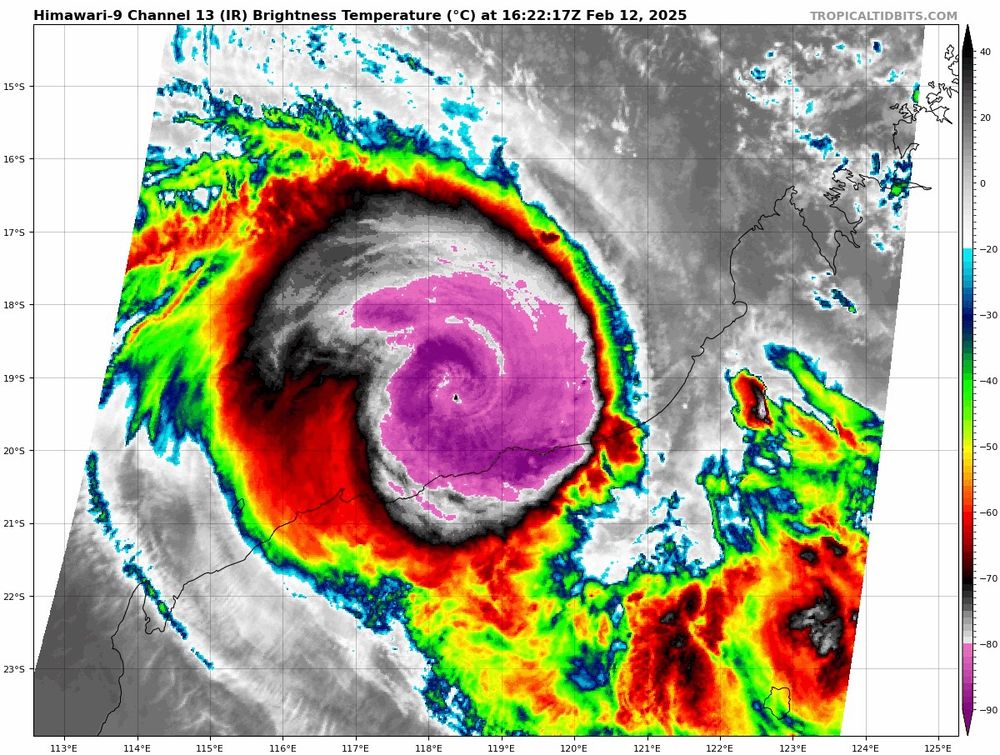
Off the northwest coast of Australia, Cyclone Zelia appears to be intensifying quite quickly. Some of the hurricane guidance brings the system up to the equivalent of category-5 intensity before landfall. Hopefully that’s overly aggressive.
February 12, 2025 at 5:08 PM
Off the northwest coast of Australia, Cyclone Zelia appears to be intensifying quite quickly. Some of the hurricane guidance brings the system up to the equivalent of category-5 intensity before landfall. Hopefully that’s overly aggressive.
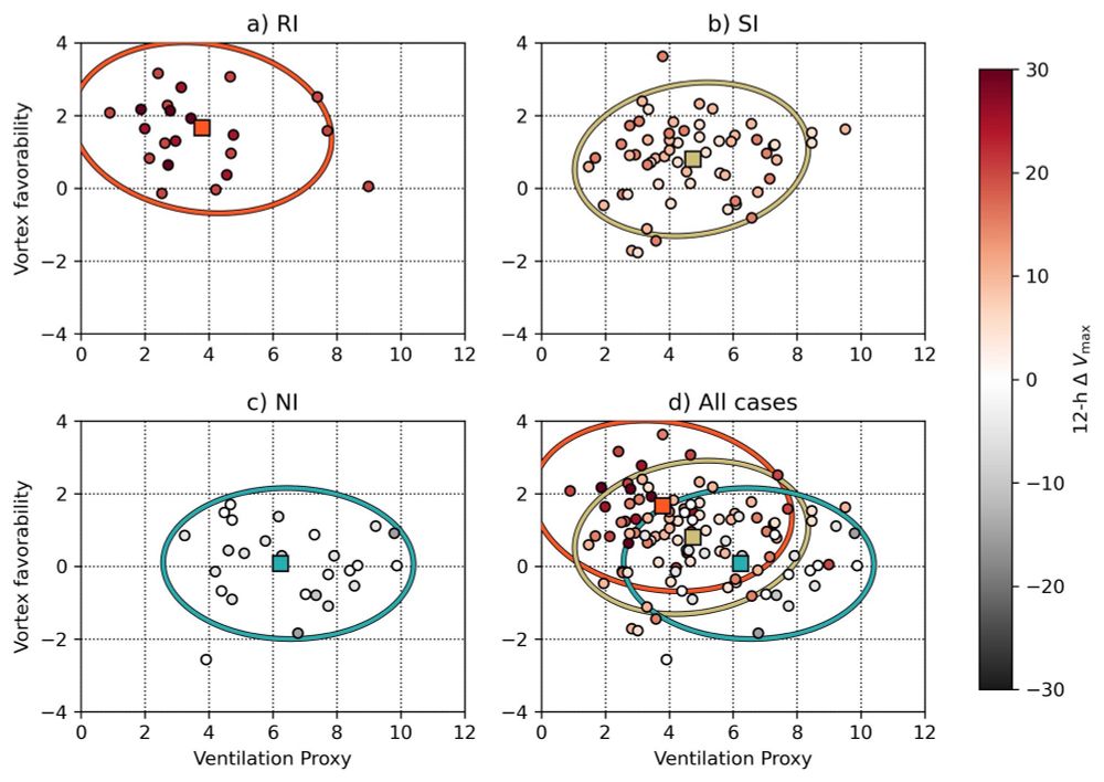
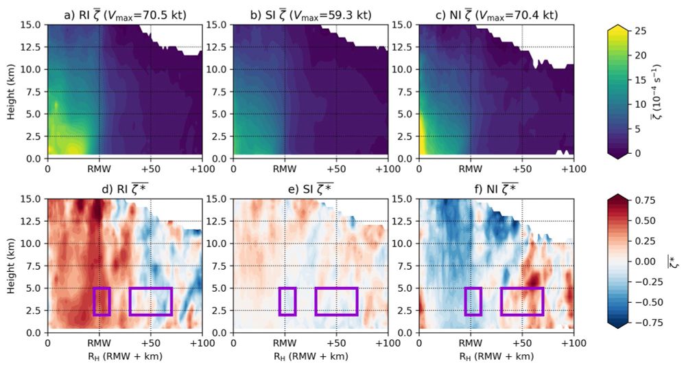
To summarize: RI tends to occur in vortices that are anomalously tall and narrow and in TCs with anomalously deep convection in the TC inner core. We hypothesize this helps evacuate mass out of the boundary layer, leading to the inward advection of angular momentum surfaces.
December 13, 2024 at 10:33 PM
To summarize: RI tends to occur in vortices that are anomalously tall and narrow and in TCs with anomalously deep convection in the TC inner core. We hypothesize this helps evacuate mass out of the boundary layer, leading to the inward advection of angular momentum surfaces.
Based on those purple boxes above, we compute a metric of "vortex favorability" for RI. When plotted versus a metric of environmental favorability (smaller values of the "ventilation proxy" here), you can see RI occurs preferentially in certain vortex structures and environments.
December 13, 2024 at 10:33 PM
Based on those purple boxes above, we compute a metric of "vortex favorability" for RI. When plotted versus a metric of environmental favorability (smaller values of the "ventilation proxy" here), you can see RI occurs preferentially in certain vortex structures and environments.
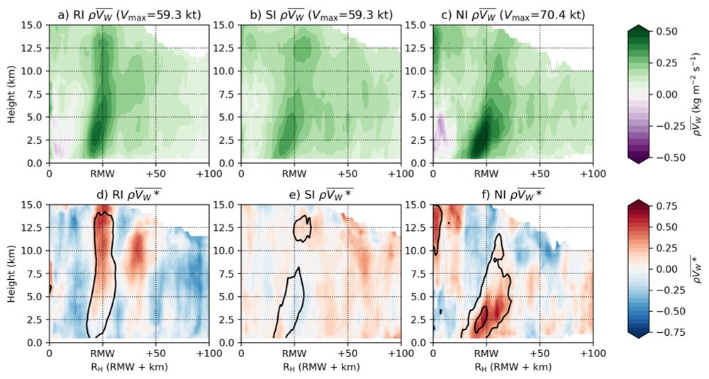
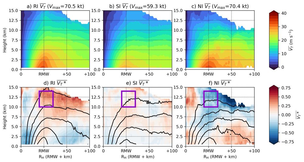
It turns out that the anomalous TC structure (relative to TC intensity) is closely related to the rate of intensity change. For example, here are composites of the observed and anomalous azimuthally-averaged tangential wind and vorticity for each intensity change group.
December 13, 2024 at 10:33 PM
It turns out that the anomalous TC structure (relative to TC intensity) is closely related to the rate of intensity change. For example, here are composites of the observed and anomalous azimuthally-averaged tangential wind and vorticity for each intensity change group.
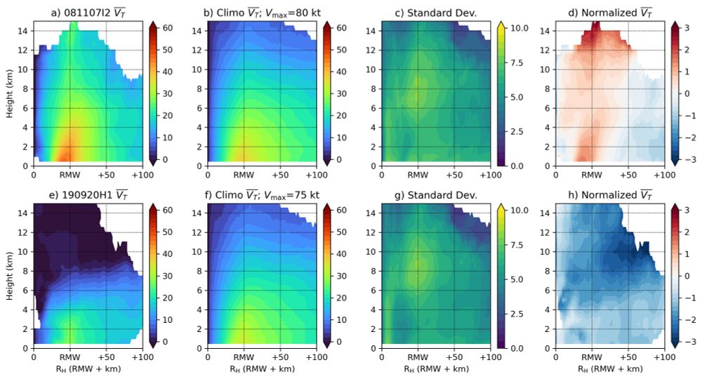
One problem: TC vortex and convective characteristics are closely related to TC intensity.
Our approach: Normalize these characteristics and explore the anomalous aspects. For example, here are standardized anomalies of azimuthally-averaged tangential wind for two cases.
Our approach: Normalize these characteristics and explore the anomalous aspects. For example, here are standardized anomalies of azimuthally-averaged tangential wind for two cases.
December 13, 2024 at 10:33 PM
One problem: TC vortex and convective characteristics are closely related to TC intensity.
Our approach: Normalize these characteristics and explore the anomalous aspects. For example, here are standardized anomalies of azimuthally-averaged tangential wind for two cases.
Our approach: Normalize these characteristics and explore the anomalous aspects. For example, here are standardized anomalies of azimuthally-averaged tangential wind for two cases.
Here, we use TC-RADAR, which is a collection of over 1,100 airborne Doppler radar analyses of TCs sampled by NOAA aircraft over the last three decades to answer this question. We compare rapidly intensifying (RI), slowly intensifying (SI), and non-intensifying (NI) TCs.
December 13, 2024 at 10:33 PM
Here, we use TC-RADAR, which is a collection of over 1,100 airborne Doppler radar analyses of TCs sampled by NOAA aircraft over the last three decades to answer this question. We compare rapidly intensifying (RI), slowly intensifying (SI), and non-intensifying (NI) TCs.
23C IR temp in the eye of Typhoon Man-Yi is very impressive! An extremely powerful typhoon approaching The Philippines.
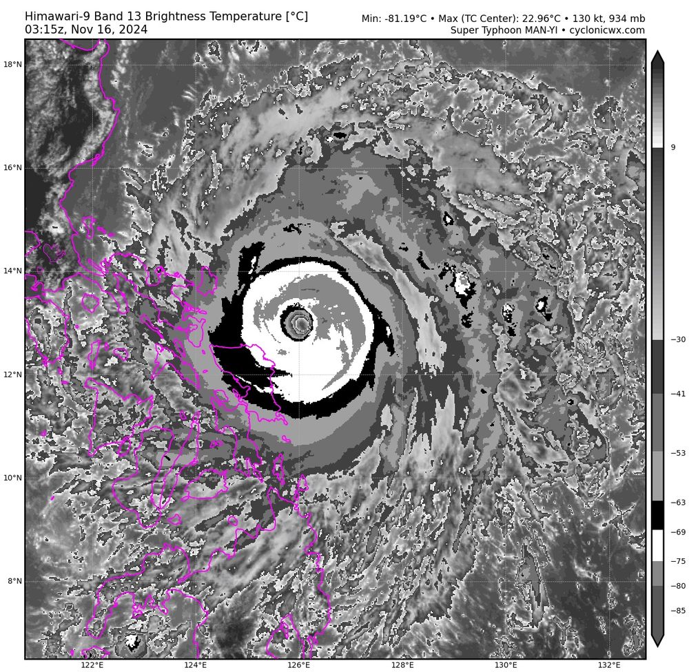
November 16, 2024 at 3:38 AM
23C IR temp in the eye of Typhoon Man-Yi is very impressive! An extremely powerful typhoon approaching The Philippines.
Interestingly, the NW Caribbean and eastern Gulf of Mexico has been a hot spot for TC activity this year and that will only continue with the expected development of 99L. The westward focus of TC activity and overall spatial distribution reminds me a bit of 2004, which was also a busy year for FL.
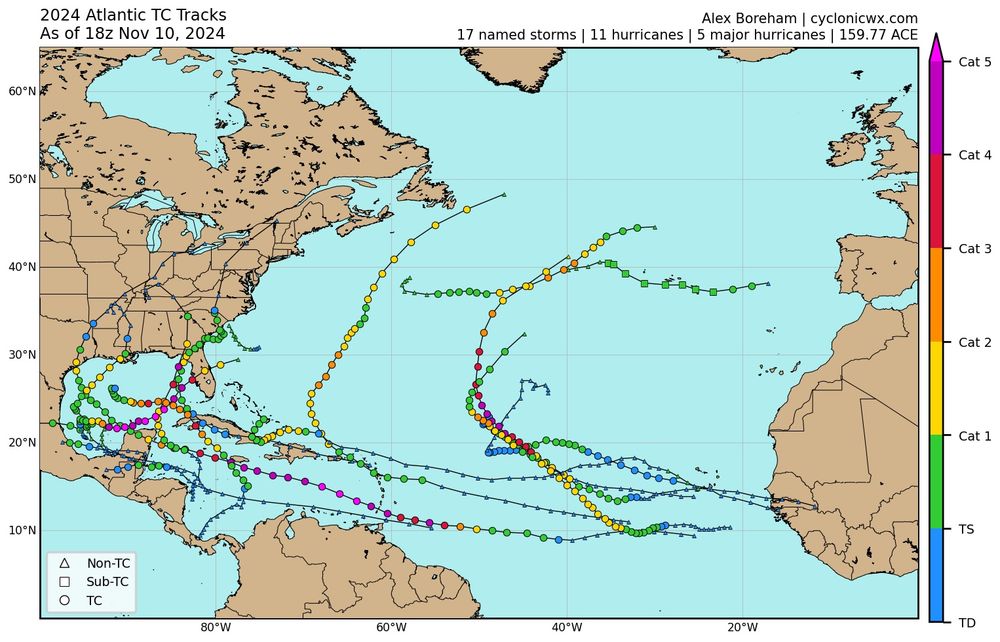
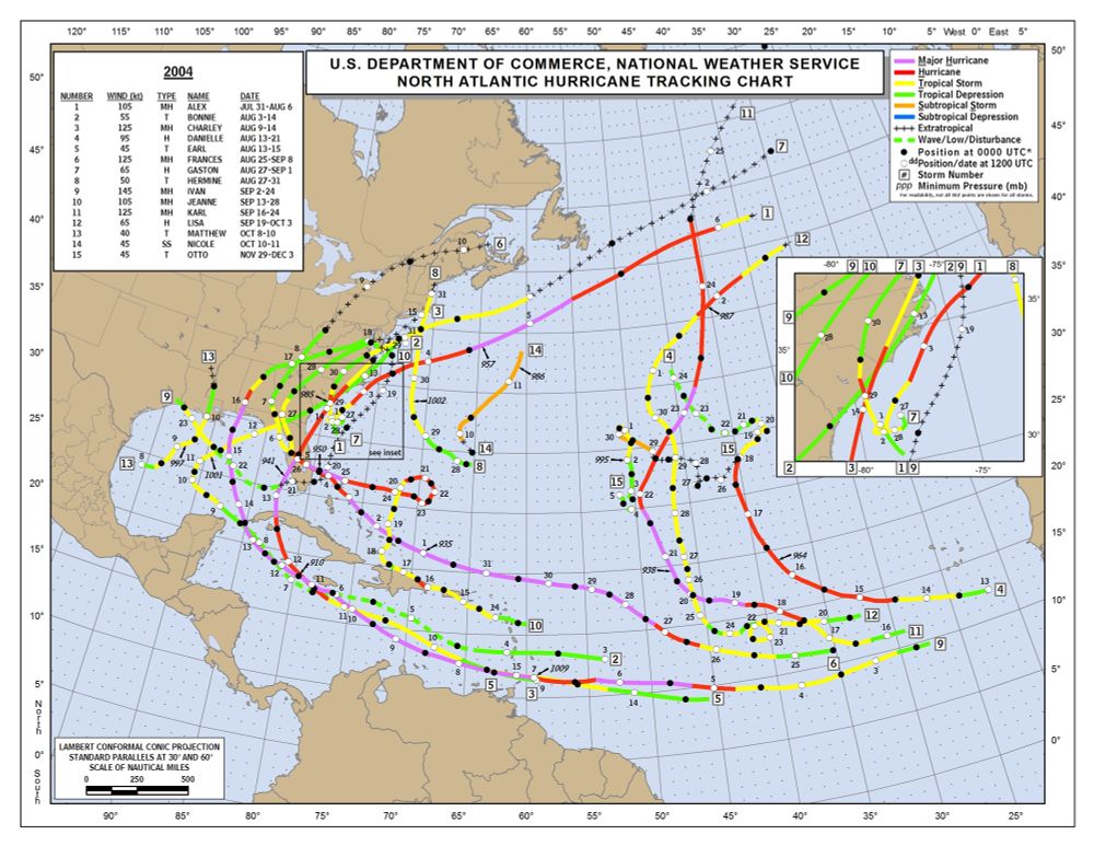
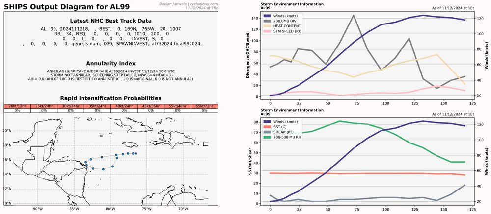
November 12, 2024 at 8:31 PM
Interestingly, the NW Caribbean and eastern Gulf of Mexico has been a hot spot for TC activity this year and that will only continue with the expected development of 99L. The westward focus of TC activity and overall spatial distribution reminds me a bit of 2004, which was also a busy year for FL.
Invest 99L appears poised to become a significant TC if it manages to avoid significant land interaction with Honduras/Nicaragua. The environment looks very favorable for intensification and the storm structure has seemingly continued to exceed short term model expectations.
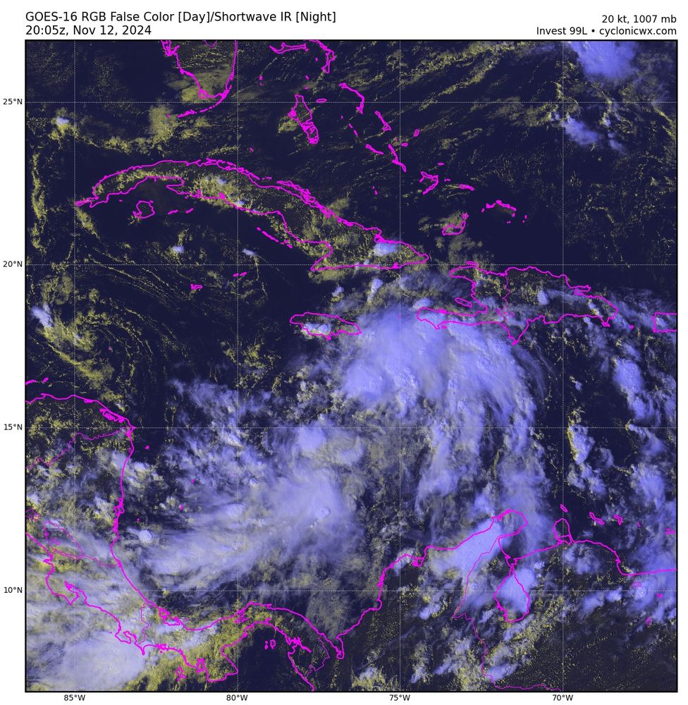
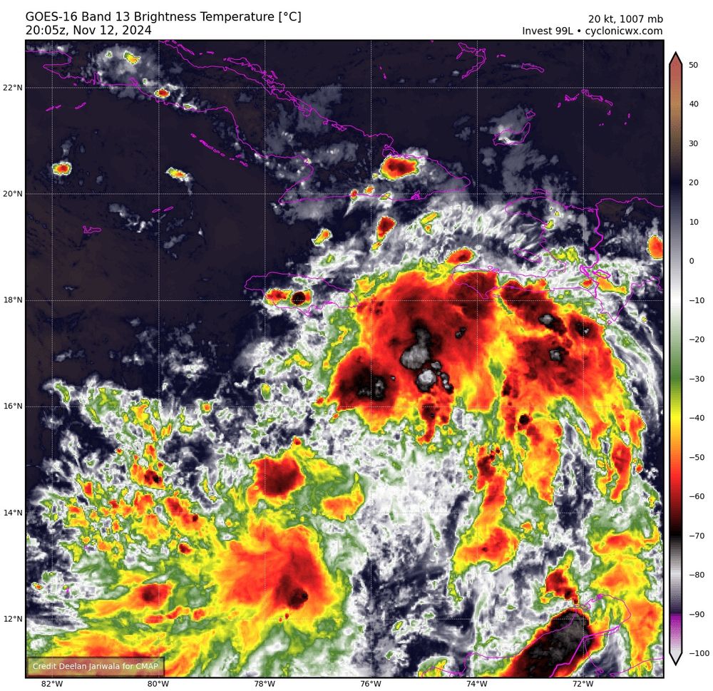
November 12, 2024 at 8:19 PM
Invest 99L appears poised to become a significant TC if it manages to avoid significant land interaction with Honduras/Nicaragua. The environment looks very favorable for intensification and the storm structure has seemingly continued to exceed short term model expectations.
Interesting low/trough near 70W and 25N this morning. Waters are still pretty warm in this area and there's ongoing deep convection with lightning (yellow markers). The disturbance is currently located on a sharp gradient of vertical wind shear.
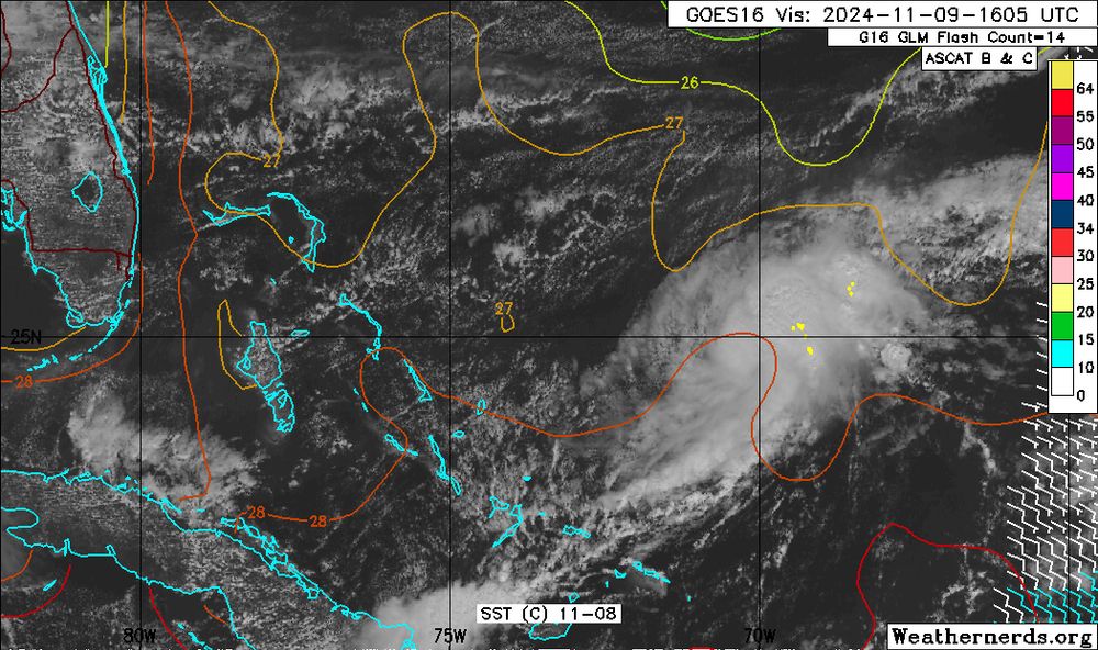
November 9, 2024 at 4:19 PM
Interesting low/trough near 70W and 25N this morning. Waters are still pretty warm in this area and there's ongoing deep convection with lightning (yellow markers). The disturbance is currently located on a sharp gradient of vertical wind shear.
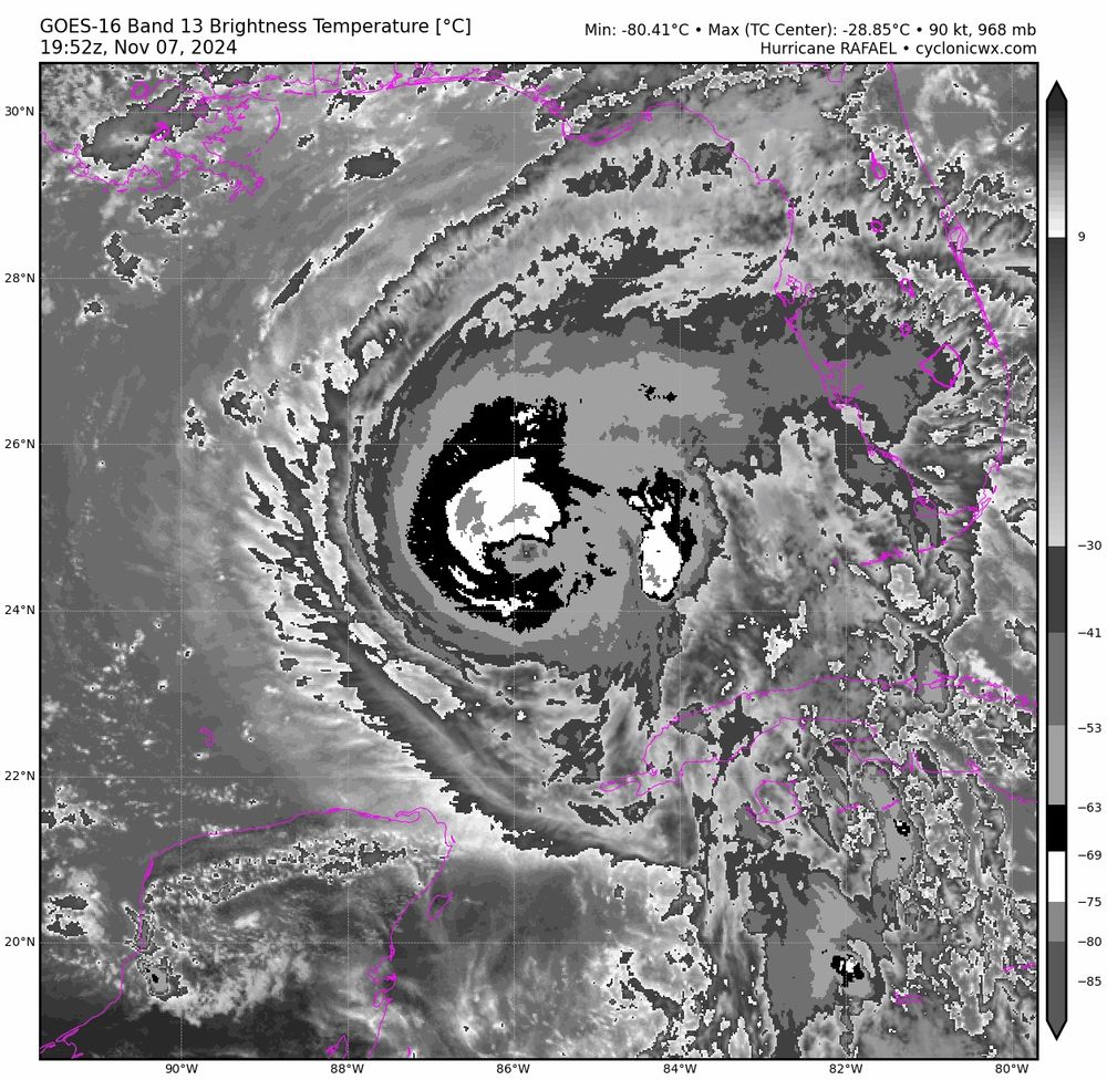
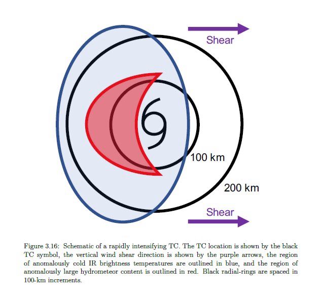
Hurricane Rafael has an interesting satellite appearance, with the coldest IR brightness temperatures on the upshear side of the storm. That’s usually a pattern we see with intensifying storms (fig. is from my dissertation), however, guidance suggests we will see a period of weakening soon. Hmm…
November 7, 2024 at 9:20 PM
Hurricane Rafael has an interesting satellite appearance, with the coldest IR brightness temperatures on the upshear side of the storm. That’s usually a pattern we see with intensifying storms (fig. is from my dissertation), however, guidance suggests we will see a period of weakening soon. Hmm…
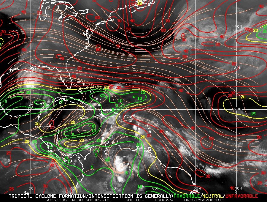
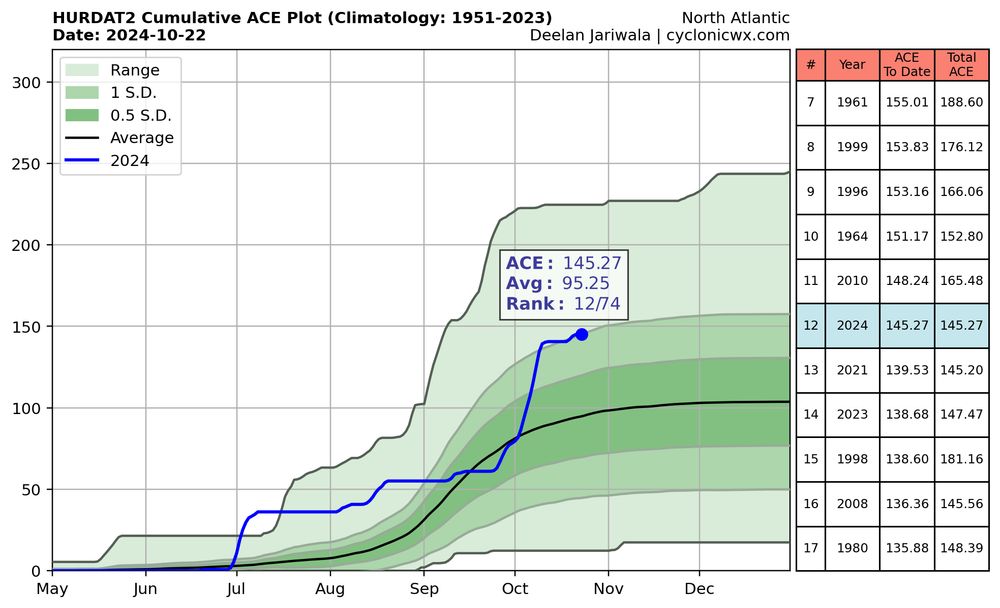
With model guidance suggesting the potential for another TC in the Caribbean in 1-2 weeks, I’m wondering if the Atlantic this year may actually reach NOAA’s “extremely active” definition of approximately 160 ACE units. Only 15 units to go. What a weird season.
October 22, 2024 at 1:15 PM
With model guidance suggesting the potential for another TC in the Caribbean in 1-2 weeks, I’m wondering if the Atlantic this year may actually reach NOAA’s “extremely active” definition of approximately 160 ACE units. Only 15 units to go. What a weird season.