


Julio Novoa
@julionovoa.bsky.social
geospatial analysis | web development | project management
Reposted by Julio Novoa

#SedonaDB : A single-node analytical database engine with #geospatial as a first-class citizen
sedona.apache.org/latest/blog/...
sedona.apache.org/latest/blog/...
Introducing SedonaDB: A single-node analytical database engine with geospatial as a first-class citizen - Apache Sedona
Apache Sedona is a cluster computing system for processing large-scale spatial data. Sedona extends existing cluster computing systems, such as Apache Spark, Apache Flink, and Snowflake, with a set of...
sedona.apache.org
September 24, 2025 at 5:46 PM
#SedonaDB : A single-node analytical database engine with #geospatial as a first-class citizen
sedona.apache.org/latest/blog/...
sedona.apache.org/latest/blog/...
Reposted by Julio Novoa
We've extensively adopted #DuckDB for our #geospatial data processing workflows, and the performance gains are remarkable. Recent benchmarks show it can outperform #Spark by 100x on medium-sized datasets while eliminating infrastructure complexity.
blog.dataexpert.io/p/duckdb-can...
blog.dataexpert.io/p/duckdb-can...
September 24, 2025 at 3:46 PM
We've extensively adopted #DuckDB for our #geospatial data processing workflows, and the performance gains are remarkable. Recent benchmarks show it can outperform #Spark by 100x on medium-sized datasets while eliminating infrastructure complexity.
blog.dataexpert.io/p/duckdb-can...
blog.dataexpert.io/p/duckdb-can...
Reposted by Julio Novoa
A great opportunity for conducting important research in the tropical forests! 🌳
#geospatial #remotesensing #sar #radarsat
#geospatial #remotesensing #sar #radarsat

RADARSAT-2 Tropical Forests: data access opportunity
A data access opportunity aims to make a unique, long-term archive of RADARSAT-2 data freely available to scientists and organizations around the world.
www.asc-csa.gc.ca
September 22, 2025 at 1:47 AM
A great opportunity for conducting important research in the tropical forests! 🌳
#geospatial #remotesensing #sar #radarsat
#geospatial #remotesensing #sar #radarsat
Reposted by Julio Novoa

New video on Svelte's best kept secret feature which helps you find any element on the page in the editor. 🔥
youtu.be/Qglbt8M8H_w
youtu.be/Qglbt8M8H_w

The Secret Svelte Feature You Should Know About
YouTube video by Joy of Code
youtu.be
September 16, 2025 at 2:00 PM
New video on Svelte's best kept secret feature which helps you find any element on the page in the editor. 🔥
youtu.be/Qglbt8M8H_w
youtu.be/Qglbt8M8H_w
✨ Learn Svelte 5 ✨

The Complete Svelte 5 Course For The Most Loved JavaScript Framework
YouTube video by Joy of Code
youtu.be
September 8, 2025 at 11:41 PM
✨ Learn Svelte 5 ✨
#Gusnet is a #QGIS plugin for designing, editing, simulating, and visualizing #water distribution #networks using #EPANET’s trusted modeling engine.
www.gusnet.org
www.gusnet.org
Gusnet Water Network Modeller — Gusnet - Piped Water Network Analysis 2.0.0 documentation
Documentation of the Gusnet plugin for QGIS
www.gusnet.org
August 24, 2025 at 5:52 AM
Reposted by Julio Novoa
I wanted to release the Svelte 5 guide later since I was thinking about interactive examples but here you go if you like reading and I would love your feedback as I work on the video. 😄
joyofcode.xyz/learn-svelte
joyofcode.xyz/learn-svelte
August 14, 2025 at 4:00 PM
I wanted to release the Svelte 5 guide later since I was thinking about interactive examples but here you go if you like reading and I would love your feedback as I work on the video. 😄
joyofcode.xyz/learn-svelte
joyofcode.xyz/learn-svelte
#TerraMind is pretrained on dual-scale representations combining both token-level and pixel-level data across modalities
#geospatial #earthobservation
#geospatial #earthobservation
IBM-ESA TerraMind
TerraMind: Large-Scale Generative Multimodality for Earth Observation
ibm.github.io
August 11, 2025 at 6:03 PM
#TerraMind is pretrained on dual-scale representations combining both token-level and pixel-level data across modalities
#geospatial #earthobservation
#geospatial #earthobservation

Google’s #AlphaEarth Foundations is a #geospatial embedding model trained on a variety of Earth observation datasets. The model enables users to build any number of fine-tuning applications without running computationally expensive #deeplearning models

Introduction to the Satellite Embedding Dataset | Google Earth Engine | Google for Developers
developers.google.com
July 31, 2025 at 6:15 AM
Google’s #AlphaEarth Foundations is a #geospatial embedding model trained on a variety of Earth observation datasets. The model enables users to build any number of fine-tuning applications without running computationally expensive #deeplearning models
#A5 is a #geospatial index that partitions the world into pentagonal cells. The cells are available at 31 different resolution levels, with the largest cell covering the whole world, and the smallest less than 30mm². Within each resolution level the cells have equal area, as per the #OGC definition.
Introduction | A5
A5 is a geospatial index that partitions the world into pentagonal cells. The cells are available at 31 different resolution levels, with the largest cell covering the whole world, and the smallest le...
a5geo.org
July 31, 2025 at 2:31 AM
#A5 is a #geospatial index that partitions the world into pentagonal cells. The cells are available at 31 different resolution levels, with the largest cell covering the whole world, and the smallest less than 30mm². Within each resolution level the cells have equal area, as per the #OGC definition.
Compile #Svelte 5 in your head

Compile Svelte 5 in your head
Background5 years ago, I wrote Compile Svelte in your head. That was written for Svelte 3.But now, almost 1 year into Svelte 5 release, which introduce tons of new features, such as runes, fine-graine...
lihautan.com
July 30, 2025 at 6:43 AM
Compile #Svelte 5 in your head
Layer Cake is a #Svelte graphics framework that creates synchronized scales from your container dimensions and data ranges. It lets you build visualizations by combining reusable SVG, HTML, Canvas, or WebGL components that share the same coordinate system.
#dataviz #layercake
#dataviz #layercake

Layer Cake
A framework for mostly-reusable graphics with svelte
layercake.graphics
July 25, 2025 at 5:23 AM
Layer Cake is a #Svelte graphics framework that creates synchronized scales from your container dimensions and data ranges. It lets you build visualizations by combining reusable SVG, HTML, Canvas, or WebGL components that share the same coordinate system.
#dataviz #layercake
#dataviz #layercake
Reposted by Julio Novoa

🚀 Visualizing Planet’s Tanager Hyperspectral Data in 3D! 🌍🛰️
Create an interactive image cube to explore the internal structure of all 426 spectral bands captured by Planet’s Tanager mission
📓 Notebook example: hypercoast.org/examples/tan...
💻 GitHub: github.com/opengeos/Hyp...
Create an interactive image cube to explore the internal structure of all 426 spectral bands captured by Planet’s Tanager mission
📓 Notebook example: hypercoast.org/examples/tan...
💻 GitHub: github.com/opengeos/Hyp...
July 21, 2025 at 3:20 AM
🚀 Visualizing Planet’s Tanager Hyperspectral Data in 3D! 🌍🛰️
Create an interactive image cube to explore the internal structure of all 426 spectral bands captured by Planet’s Tanager mission
📓 Notebook example: hypercoast.org/examples/tan...
💻 GitHub: github.com/opengeos/Hyp...
Create an interactive image cube to explore the internal structure of all 426 spectral bands captured by Planet’s Tanager mission
📓 Notebook example: hypercoast.org/examples/tan...
💻 GitHub: github.com/opengeos/Hyp...

IonQ Completes Acquisition of Capella Space, Advancing Vision for Space-Based Quantum Communications
#SAR #RemoteSensing
#SAR #RemoteSensing

IonQ Completes Acquisition of Capella Space, Advancing Vision for Space-Based Quantum Communications
Integration of Capella’s satellite capabilities positions IonQ to pioneer the first global space-based quantum key distribution network
ionq.com
July 16, 2025 at 2:25 AM
IonQ Completes Acquisition of Capella Space, Advancing Vision for Space-Based Quantum Communications
#SAR #RemoteSensing
#SAR #RemoteSensing
panel-material-ui, a #Panel extension that delivers a suite of modern components and a cohesive design system built on Material UI.
#python #dataviz
#python #dataviz

Panel Material UI Announcement – HoloViz Blog
Announcing the release of panel-material-ui, a new extension that wraps Material UI components in Panel.
blog.holoviz.org
July 12, 2025 at 5:48 AM
#drawDB: Free and open source, simple, and intuitive #database design editor, data-modeler, and #SQL generator

drawDB | Online database diagram editor and SQL generator
Online database entity-realtionship diagram editor, data modeler, and SQL generator. Design, visualize, and export scripts without an account and completely free of charge.
www.drawdb.app
July 10, 2025 at 5:08 AM
Reposted by Julio Novoa
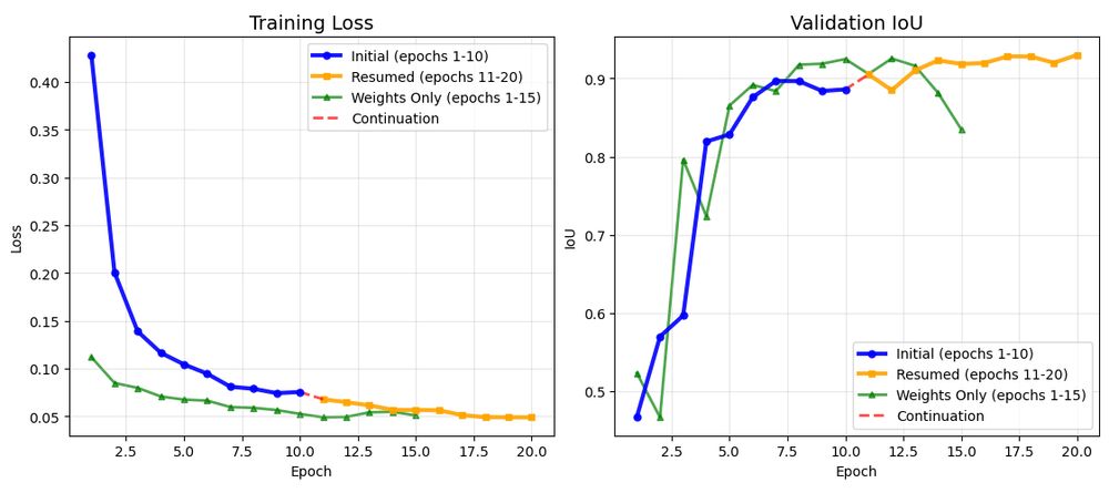
🚀 The GeoAI Python package now allows you to easily load a model checkpoint and resume training with just one line of code! 🌟 This is particularly helpful for those times when training gets interrupted or when you want to fine-tune an existing model for different segmentation tasks.
July 7, 2025 at 8:15 PM
🚀 The GeoAI Python package now allows you to easily load a model checkpoint and resume training with just one line of code! 🌟 This is particularly helpful for those times when training gets interrupted or when you want to fine-tune an existing model for different segmentation tasks.
📢 Exciting news for QGIS users! 🚀 Starting with version 3.44, new geometric and topological checks and corrections are available. Create automated validation chains with 21 verification and 10 correction processes! #QGIS #GIS #Geospatial

Geometric and Topological Checks and Corrections in QGIS
Credits: Pixabay (Pixabay Content License)
The Importance of Compliance
A geographic data layer must comply with many rules and constraints.
For example:
Geometric
Topological
Arbitrary rule...
oslandia.com
July 5, 2025 at 3:48 AM
📢 Exciting news for QGIS users! 🚀 Starting with version 3.44, new geometric and topological checks and corrections are available. Create automated validation chains with 21 verification and 10 correction processes! #QGIS #GIS #Geospatial

Reposted by Julio Novoa

The hardest part about reusing charts can be getting your data into the expected shape. Learn common data formats consumed by Plot & D3 — and how to transform your data to match — so you can quickly reuse thousands of stunning, interactive visualizations: buff.ly/rJaX6pT
June 26, 2025 at 7:30 PM
The hardest part about reusing charts can be getting your data into the expected shape. Learn common data formats consumed by Plot & D3 — and how to transform your data to match — so you can quickly reuse thousands of stunning, interactive visualizations: buff.ly/rJaX6pT
The ESA Biomass satellite has delivered its striking first images! This mission will provide crucial data on forest biomass and global carbon cycles, enhancing our understanding of Earth's ecosystems. #ESA #Biomass #EarthObservation #Forests #ClimateScience

Biomass satellite returns striking first images of forests and more
Today, at the Living Planet Symposium, ESA revealed the first stunning images from its groundbreaking Biomass satellite mission – marking a major leap forward in our ability to understand how Earth’s ...
www.esa.int
June 26, 2025 at 6:11 AM
The ESA Biomass satellite has delivered its striking first images! This mission will provide crucial data on forest biomass and global carbon cycles, enhancing our understanding of Earth's ecosystems. #ESA #Biomass #EarthObservation #Forests #ClimateScience
Enhance your ArcGIS Enterprise strategy! Discover crucial tips for managing geodatabase upgrades in a service-based architecture, ensuring smooth transitions and optimal system performance. Get practical advice on aligning your client and geodatabase for a successful upgrade. #Esri #ArcGIS

Manage geodatabase upgrades in a service-based architecture
Learn how to manage enterprise geodatabase upgrades in ArcGIS service-based architectures. Understand when upgrades are needed, which client to use, and how to apply them using ArcGIS Pro or ArcGIS En...
www.esri.com
June 26, 2025 at 3:11 AM