


stephen hernandez
@hernarado.bsky.social
Reposted by stephen hernandez

In a new #BSSA paper, scientists consider why Alaska seismic station NP.ARTY experiences higher ground acceleration than other nearby stations. They found that local topography and shallow low-velocity material play important roles in amplification. ⚒️
pubs.geoscienceworld.org/ssa/bssa/art...
pubs.geoscienceworld.org/ssa/bssa/art...

October 24, 2025 at 9:02 PM
In a new #BSSA paper, scientists consider why Alaska seismic station NP.ARTY experiences higher ground acceleration than other nearby stations. They found that local topography and shallow low-velocity material play important roles in amplification. ⚒️
pubs.geoscienceworld.org/ssa/bssa/art...
pubs.geoscienceworld.org/ssa/bssa/art...
Reposted by stephen hernandez
🌟OPEN ACCESS🌟 Although Australia isn’t known for high seismicity, it does experience moderate to large earthquakes. A new #BSSA paper presents a way to resolve source parameters for well-recorded post-1994 earthquakes within Australia. ⚒️
pubs.geoscienceworld.org/ssa/bssa/art...
pubs.geoscienceworld.org/ssa/bssa/art...

October 25, 2025 at 4:00 AM
🌟OPEN ACCESS🌟 Although Australia isn’t known for high seismicity, it does experience moderate to large earthquakes. A new #BSSA paper presents a way to resolve source parameters for well-recorded post-1994 earthquakes within Australia. ⚒️
pubs.geoscienceworld.org/ssa/bssa/art...
pubs.geoscienceworld.org/ssa/bssa/art...
Reposted by stephen hernandez
How might a sudden change in slab dip affect rupture propagation? A new #SRL paper proposes that in the case of megathrusts that occur south of the Alaska Peninsula, such as change may have acted as a barrier for two recent quakes. ⚒️
pubs.geoscienceworld.org/ssa/srl/arti...
pubs.geoscienceworld.org/ssa/srl/arti...

October 24, 2025 at 10:02 PM
How might a sudden change in slab dip affect rupture propagation? A new #SRL paper proposes that in the case of megathrusts that occur south of the Alaska Peninsula, such as change may have acted as a barrier for two recent quakes. ⚒️
pubs.geoscienceworld.org/ssa/srl/arti...
pubs.geoscienceworld.org/ssa/srl/arti...
Reposted by stephen hernandez
Parallel Seismic Data Processing Performance with Cloud‐Based Storage #SRL
What does cloud computing really mean with respect to seismology?
pubs.geoscienceworld.org/ssa/srl/arti...
What does cloud computing really mean with respect to seismology?
pubs.geoscienceworld.org/ssa/srl/arti...

October 13, 2025 at 3:02 PM
Parallel Seismic Data Processing Performance with Cloud‐Based Storage #SRL
What does cloud computing really mean with respect to seismology?
pubs.geoscienceworld.org/ssa/srl/arti...
What does cloud computing really mean with respect to seismology?
pubs.geoscienceworld.org/ssa/srl/arti...
Reposted by stephen hernandez

#ComunidadIG Mejoras y optimización de redes de vigilancia sísmica y geodésica en el volcán #SierraNegra.
Más información en el siguiente enlace:
👉 igepn.short.gy/Oaf4Nj
Más información en el siguiente enlace:
👉 igepn.short.gy/Oaf4Nj

September 9, 2025 at 4:11 PM
#ComunidadIG Mejoras y optimización de redes de vigilancia sísmica y geodésica en el volcán #SierraNegra.
Más información en el siguiente enlace:
👉 igepn.short.gy/Oaf4Nj
Más información en el siguiente enlace:
👉 igepn.short.gy/Oaf4Nj
Reposted by stephen hernandez
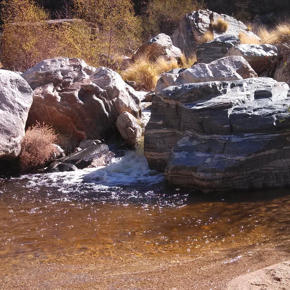
A summary of our recent fieldwork in Galapagos (which came out when I was on strike last week). With @hernarado.bsky.social @volcanodr.bsky.social @earthscope.org
#ComunidadIG Mejoras y optimización de redes de vigilancia sísmica y geodésica en el volcán #SierraNegra.
Más información en el siguiente enlace:
👉 igepn.short.gy/Oaf4Nj
Más información en el siguiente enlace:
👉 igepn.short.gy/Oaf4Nj
September 16, 2025 at 12:41 PM
A summary of our recent fieldwork in Galapagos (which came out when I was on strike last week). With @hernarado.bsky.social @volcanodr.bsky.social @earthscope.org
Reposted by stephen hernandez
M4.3 shallow #earthquake near Berkeley, CA a few hours ago, strike slip mechanism, possibly on the Hayward Fault Zone. ⚒️🧪
earthquake.usgs.gov/earthquakes/...
earthquake.usgs.gov/earthquakes/...

September 22, 2025 at 11:01 AM
M4.3 shallow #earthquake near Berkeley, CA a few hours ago, strike slip mechanism, possibly on the Hayward Fault Zone. ⚒️🧪
earthquake.usgs.gov/earthquakes/...
earthquake.usgs.gov/earthquakes/...
Reposted by stephen hernandez

M4.3 earthquake near Berkeley as recorded by a seismic station near Hollister, CA.


September 22, 2025 at 12:07 PM
M4.3 earthquake near Berkeley as recorded by a seismic station near Hollister, CA.
Reposted by stephen hernandez
La ceniza volcánica es roca pulverizada que puede afectar la salud humana, la vegetación y los animales.
😷 Usa mascarilla y gafas
🌿 Sacude las hojas
🐾 Protege a tus mascotas
La prevención empieza con el conocimiento.
📚 alertasecuador.gob.ec/volcan
📚 igepn.edu.ec/mapas/amenaz...
😷 Usa mascarilla y gafas
🌿 Sacude las hojas
🐾 Protege a tus mascotas
La prevención empieza con el conocimiento.
📚 alertasecuador.gob.ec/volcan
📚 igepn.edu.ec/mapas/amenaz...
September 10, 2025 at 5:04 PM
La ceniza volcánica es roca pulverizada que puede afectar la salud humana, la vegetación y los animales.
😷 Usa mascarilla y gafas
🌿 Sacude las hojas
🐾 Protege a tus mascotas
La prevención empieza con el conocimiento.
📚 alertasecuador.gob.ec/volcan
📚 igepn.edu.ec/mapas/amenaz...
😷 Usa mascarilla y gafas
🌿 Sacude las hojas
🐾 Protege a tus mascotas
La prevención empieza con el conocimiento.
📚 alertasecuador.gob.ec/volcan
📚 igepn.edu.ec/mapas/amenaz...
Reposted by stephen hernandez

Taxi-H2OTaxi-Lancha-H2OTaxi-Taxi-H2OTaxi-Bus-Plane. Back to Quito after a successful 2 weeks of geodetic & seismic research w/ @igepnecuador.bsky.social @andyfbell.bsky.social @hernarado.bsky.social @earthscope.org @ Sierra Negra volcano.
August 22, 2025 at 8:43 PM
Taxi-H2OTaxi-Lancha-H2OTaxi-Taxi-H2OTaxi-Bus-Plane. Back to Quito after a successful 2 weeks of geodetic & seismic research w/ @igepnecuador.bsky.social @andyfbell.bsky.social @hernarado.bsky.social @earthscope.org @ Sierra Negra volcano.
Reposted by stephen hernandez
Improving the Transportability of a Deep Learning Denoising Model Using Transfer Learning Techniques #SRL ⚒️
How can transportability of deep learning denoising methods be improved?
pubs.geoscienceworld.org/ssa/srl/arti...
How can transportability of deep learning denoising methods be improved?
pubs.geoscienceworld.org/ssa/srl/arti...

September 11, 2025 at 5:00 PM
Improving the Transportability of a Deep Learning Denoising Model Using Transfer Learning Techniques #SRL ⚒️
How can transportability of deep learning denoising methods be improved?
pubs.geoscienceworld.org/ssa/srl/arti...
How can transportability of deep learning denoising methods be improved?
pubs.geoscienceworld.org/ssa/srl/arti...
Reposted by stephen hernandez


August 21, 2025 at 1:36 PM
Reposted by stephen hernandez
LAB2022: A New Nodal Seismic Array Spanning the Los Angeles Basin #SRL ⚒️
Interested in seismic velocity changes of the LA Basin? Check out this new paper!
pubs.geoscienceworld.org/ssa/srl/arti...
Interested in seismic velocity changes of the LA Basin? Check out this new paper!
pubs.geoscienceworld.org/ssa/srl/arti...

August 20, 2025 at 2:02 PM
LAB2022: A New Nodal Seismic Array Spanning the Los Angeles Basin #SRL ⚒️
Interested in seismic velocity changes of the LA Basin? Check out this new paper!
pubs.geoscienceworld.org/ssa/srl/arti...
Interested in seismic velocity changes of the LA Basin? Check out this new paper!
pubs.geoscienceworld.org/ssa/srl/arti...
Reposted by stephen hernandez
Is the recent 2022 magnitude 6.4 earthquake that struck near Ferndale, California, a repeat of a previous event that occurred in the same region, 47 years prior? Find out in this new #SRL paper ⚒️
pubs.geoscienceworld.org/ssa/srl/arti...
pubs.geoscienceworld.org/ssa/srl/arti...

August 5, 2025 at 2:00 AM
Is the recent 2022 magnitude 6.4 earthquake that struck near Ferndale, California, a repeat of a previous event that occurred in the same region, 47 years prior? Find out in this new #SRL paper ⚒️
pubs.geoscienceworld.org/ssa/srl/arti...
pubs.geoscienceworld.org/ssa/srl/arti...
Reposted by stephen hernandez
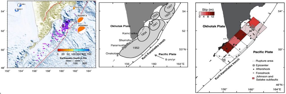
Another quick comparison of the 1952 #Kamchatka #earthquake from MacInnes et al. (2010) with today’s M8.8 event. The aftershock areas are similar, as well as one region of foreshocks. The updated USGS rupture model has a max slip of 10m versus 12m for 1952, with SW rupture direction. 🧪⚒️
July 30, 2025 at 12:37 PM
Another quick comparison of the 1952 #Kamchatka #earthquake from MacInnes et al. (2010) with today’s M8.8 event. The aftershock areas are similar, as well as one region of foreshocks. The updated USGS rupture model has a max slip of 10m versus 12m for 1952, with SW rupture direction. 🧪⚒️
Reposted by stephen hernandez
Auto slipmap with regional records (SLIPNEAR method, Géoazur/OCA) M 7.3 - ALASKA - 2025-07-16 20:37:39 (UTC)
Plane striking N343 (NNW-SSE) shown.
Rupture direction to the South-East constrained by nearby stations (quite opposite to the USGS result).
Thanks to seismic records through IRIS
Plane striking N343 (NNW-SSE) shown.
Rupture direction to the South-East constrained by nearby stations (quite opposite to the USGS result).
Thanks to seismic records through IRIS

July 17, 2025 at 9:36 AM
Auto slipmap with regional records (SLIPNEAR method, Géoazur/OCA) M 7.3 - ALASKA - 2025-07-16 20:37:39 (UTC)
Plane striking N343 (NNW-SSE) shown.
Rupture direction to the South-East constrained by nearby stations (quite opposite to the USGS result).
Thanks to seismic records through IRIS
Plane striking N343 (NNW-SSE) shown.
Rupture direction to the South-East constrained by nearby stations (quite opposite to the USGS result).
Thanks to seismic records through IRIS
Reposted by stephen hernandez
“The village’s 300 inhabitants had to leave their homes on 19 May after geologists monitoring the area warned that the glacier appeared unstable. Now many of them may never be able to return.
Climate change is causing the glaciers – frozen rivers of ice – to melt faster and faster..”
Climate change is causing the glaciers – frozen rivers of ice – to melt faster and faster..”

Swiss glacier collapse buries most of village of Blatten
The Swiss village of Blatten has been partially destroyed after a huge chunk of glacier crashed down into the valley. Although the village had been evacuated some days ago because of fears the Birch
brandednepal.com
May 28, 2025 at 8:51 PM
“The village’s 300 inhabitants had to leave their homes on 19 May after geologists monitoring the area warned that the glacier appeared unstable. Now many of them may never be able to return.
Climate change is causing the glaciers – frozen rivers of ice – to melt faster and faster..”
Climate change is causing the glaciers – frozen rivers of ice – to melt faster and faster..”
Reposted by stephen hernandez
⚒️ 🧪
Two weeks ago, a video appeared showing slip in the Myanmar earthquake - the first time this has ever been recorded on video.
What can we learn from it? We deep-dive the science.
earthquakeinsights.substack.com/p/remarkable...
Two weeks ago, a video appeared showing slip in the Myanmar earthquake - the first time this has ever been recorded on video.
What can we learn from it? We deep-dive the science.
earthquakeinsights.substack.com/p/remarkable...
Remarkable video captures fault slip in the Myanmar earthquake
We deep dive the possibilities presented by a witnessed rupture
earthquakeinsights.substack.com
May 28, 2025 at 4:03 PM
⚒️ 🧪
Two weeks ago, a video appeared showing slip in the Myanmar earthquake - the first time this has ever been recorded on video.
What can we learn from it? We deep-dive the science.
earthquakeinsights.substack.com/p/remarkable...
Two weeks ago, a video appeared showing slip in the Myanmar earthquake - the first time this has ever been recorded on video.
What can we learn from it? We deep-dive the science.
earthquakeinsights.substack.com/p/remarkable...
Reposted by stephen hernandez
Pretty convinced that our work at Saint Louis University on the Cauca Cluster earthquakes has developed to the point we can probably make a fairly decisive argument on the cause or causes of the intermediate depth earthquakes....
Maybe we pitch it at AGU this December, if US science still exists?
Maybe we pitch it at AGU this December, if US science still exists?
May 28, 2025 at 11:44 PM
Pretty convinced that our work at Saint Louis University on the Cauca Cluster earthquakes has developed to the point we can probably make a fairly decisive argument on the cause or causes of the intermediate depth earthquakes....
Maybe we pitch it at AGU this December, if US science still exists?
Maybe we pitch it at AGU this December, if US science still exists?
Reposted by stephen hernandez
There's a great paper by Dave Hill (former USGS seismologist) about the Mammoth crisis at link.springer.com/chapter/10.1...) He spent much of his career running the Long Valley Observatory (now CalVO) and working to repair trust in the USGS in Mammoth.
Volcanic Unrest and Hazard Communication in Long Valley Volcanic Region, California
The onset of volcanic unrest in Long Valley Caldera, California, in 1980 and the subsequent fluctuations in unrest levels through May 2016 illustrate: (1) the evolving relations between scientists mon...
link.springer.com
May 21, 2025 at 5:04 PM
There's a great paper by Dave Hill (former USGS seismologist) about the Mammoth crisis at link.springer.com/chapter/10.1...) He spent much of his career running the Long Valley Observatory (now CalVO) and working to repair trust in the USGS in Mammoth.
Reposted by stephen hernandez

Reposted by stephen hernandez
Definitely "full screen" the last two images. ⚒️


March 5, 2025 at 11:16 AM
Definitely "full screen" the last two images. ⚒️
Reposted by stephen hernandez
DAS meets the Moho! New paper in Science Advances w/ Zhongwen Zhan. We developed a method for finding Moho reflections in DAS data. One event can yield 10s of km of fine-scale Moho depth measurements. We applied it to dozens of SoCal events and learned a lot about the Garlock, Coso, and more.

Fine-scale Southern California Moho structure uncovered with distributed acoustic sensing
The Moho reflected phase measured by DAS shows abrupt crustal thickness changes across the Garlock Fault and Coso Volcanic Field.
doi.org
November 27, 2024 at 7:34 PM
DAS meets the Moho! New paper in Science Advances w/ Zhongwen Zhan. We developed a method for finding Moho reflections in DAS data. One event can yield 10s of km of fine-scale Moho depth measurements. We applied it to dozens of SoCal events and learned a lot about the Garlock, Coso, and more.
Reposted by stephen hernandez

Hi Seismo-Bluesky! I decided to test a pipeline with SeisBench, PyOcto, NonLinLoc, and HypoDD on the Santorini sequence. The level of activity (>4,500 events) is truly stunning! There are repeated bursts migrating backwards and forwards, spreading outwards from a narrow, almost linear channel.
February 10, 2025 at 1:23 PM
Hi Seismo-Bluesky! I decided to test a pipeline with SeisBench, PyOcto, NonLinLoc, and HypoDD on the Santorini sequence. The level of activity (>4,500 events) is truly stunning! There are repeated bursts migrating backwards and forwards, spreading outwards from a narrow, almost linear channel.
Reposted by stephen hernandez

The most iconic figure in the environmental sciences is the Keeling Curve, the CO₂ record from Mauna Loa, Hawaii.
@noaa.gov had a wonderful site where you could visualize and download these data, and now it's just gone. These data belong to us and we should not let this happen!
@noaa.gov had a wonderful site where you could visualize and download these data, and now it's just gone. These data belong to us and we should not let this happen!
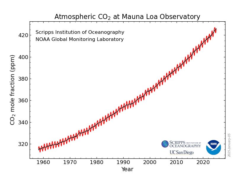
February 5, 2025 at 11:38 AM
The most iconic figure in the environmental sciences is the Keeling Curve, the CO₂ record from Mauna Loa, Hawaii.
@noaa.gov had a wonderful site where you could visualize and download these data, and now it's just gone. These data belong to us and we should not let this happen!
@noaa.gov had a wonderful site where you could visualize and download these data, and now it's just gone. These data belong to us and we should not let this happen!