


Chris Fogarty, PhD
@cyclone-fogarty.bsky.social
Meteorologist/Manager at the Canadian Hurricane Centre
@ECCC_CHC
| Tropical cyclone (hurricane) and many weather related topics | postings are own not employer
@ECCC_CHC
| Tropical cyclone (hurricane) and many weather related topics | postings are own not employer
VERY rare for parts of northern Florida to drop below freezing for the first time of the season before parts of Nova Scotia! www.jacksonville.com/story/weathe...
How cold did it get in Florida? Did it snow? Here's where low temps broke records Tuesday
All over the state, Florida's records for cold weather Nov. 11 were broken or tied thanks to an unseasonably polar blast from the north.
www.jacksonville.com
November 11, 2025 at 5:27 PM
VERY rare for parts of northern Florida to drop below freezing for the first time of the season before parts of Nova Scotia! www.jacksonville.com/story/weathe...
Reposted by Chris Fogarty, PhD

Early online release!
"Redrawing Risks: How Professional Users Interpret and Use an Iteratively Redesigned Hurricane Threats and Impacts Graphic"
journals.ametsoc.org/view/journal...
"Redrawing Risks: How Professional Users Interpret and Use an Iteratively Redesigned Hurricane Threats and Impacts Graphic"
journals.ametsoc.org/view/journal...
journals.ametsoc.org
November 10, 2025 at 11:51 PM
Early online release!
"Redrawing Risks: How Professional Users Interpret and Use an Iteratively Redesigned Hurricane Threats and Impacts Graphic"
journals.ametsoc.org/view/journal...
"Redrawing Risks: How Professional Users Interpret and Use an Iteratively Redesigned Hurricane Threats and Impacts Graphic"
journals.ametsoc.org/view/journal...
Thursday weather here in Halifax expected to be quite similar to yesterday's...cool NW winds with showers especially in the morning. If you're around the waterfront or shoreline you'll notice the water level particularly high around 8 am due to full moon and low pressure. #nswx
November 5, 2025 at 7:26 PM
Thursday weather here in Halifax expected to be quite similar to yesterday's...cool NW winds with showers especially in the morning. If you're around the waterfront or shoreline you'll notice the water level particularly high around 8 am due to full moon and low pressure. #nswx


CASHR - Super-Res Reflectivity Tilt 1 5:59 PM AST Super-Res Velocity Tilt 2 5:58 PM AST #NLwx
x.com/i/status/198...
x.com/i/status/198...

Chris Fogarty, PhD on X: "CASHR - Super-Res Reflectivity Tilt 1 5:59 PM AST Super-Res Velocity Tilt 2 5:58 PM AST #NLwx https://t.co/q7OS8oE86n" / X
CASHR - Super-Res Reflectivity Tilt 1 5:59 PM AST Super-Res Velocity Tilt 2 5:58 PM AST #NLwx https://t.co/q7OS8oE86n
x.com
November 4, 2025 at 10:05 PM
CASHR - Super-Res Reflectivity Tilt 1 5:59 PM AST Super-Res Velocity Tilt 2 5:58 PM AST #NLwx
x.com/i/status/198...
x.com/i/status/198...
Detailed VIS satellite animation of today's deep cyclone south of Newfoundland - may take a bit to load the loop. rammb-slider.cira.colostate.edu?sat=goes-19&... #nswx #pewx #nlwx

November 4, 2025 at 4:25 PM
Detailed VIS satellite animation of today's deep cyclone south of Newfoundland - may take a bit to load the loop. rammb-slider.cira.colostate.edu?sat=goes-19&... #nswx #pewx #nlwx


Sunset in Halifax and areas west may be kind of cool with the cloud patterns/edge and the departing weather system. Share your pics. #nswx
October 31, 2025 at 7:32 PM
Sunset in Halifax and areas west may be kind of cool with the cloud patterns/edge and the departing weather system. Share your pics. #nswx
Impacts in Jamaica before/after (aerial). www.bbc.com/news/article...

Before and after: Satellite images reveal hurricane devastation in Jamaica
The images reveal how the Category 5 hurricane caused devastation in some of Jamaica's communities.
www.bbc.com
October 31, 2025 at 7:07 PM
Impacts in Jamaica before/after (aerial). www.bbc.com/news/article...

Reposted by Chris Fogarty, PhD

The three Category 5 storms of the 2025 Atlantic hurricane season.
October 30, 2025 at 9:57 PM
The three Category 5 storms of the 2025 Atlantic hurricane season.
Halloween Oct 31 day weather for Halifax: windy, wet, mild during the day then wind shift/rain ending BY evening (as of now). Winds less strong in evening. High ~16C then ~11C by late evening...surfaces will be wet. Saturday eve: drier, cooler (7-9C) #nswx

October 29, 2025 at 9:56 PM
Halloween Oct 31 day weather for Halifax: windy, wet, mild during the day then wind shift/rain ending BY evening (as of now). Winds less strong in evening. High ~16C then ~11C by late evening...surfaces will be wet. Saturday eve: drier, cooler (7-9C) #nswx
Reposted by Chris Fogarty, PhD

Waiting on a dropsonde to confirm, but Melissa is most certainly below 900 hPa right now.
Tragically we are about to witness the 2nd or 1st deepest Atlantic hurricane landfall by min MSLP on record in Jamaica.
Tragically we are about to witness the 2nd or 1st deepest Atlantic hurricane landfall by min MSLP on record in Jamaica.

October 28, 2025 at 12:41 PM
Waiting on a dropsonde to confirm, but Melissa is most certainly below 900 hPa right now.
Tragically we are about to witness the 2nd or 1st deepest Atlantic hurricane landfall by min MSLP on record in Jamaica.
Tragically we are about to witness the 2nd or 1st deepest Atlantic hurricane landfall by min MSLP on record in Jamaica.
On Saturday driving over Mt Thom the blueberry fields next to the highway were beaming bright red as they usually do in late October. This and others also stand out in high-resolution satellite image.


October 28, 2025 at 1:05 AM
On Saturday driving over Mt Thom the blueberry fields next to the highway were beaming bright red as they usually do in late October. This and others also stand out in high-resolution satellite image.
Will Hurricane Melissa play any role in Atlantic Canada's weather? Still too early to know. There may be some wind/rain around Halloween even without Melissa. Here is a model prediction of the weather pattern Friday. #nswx

October 27, 2025 at 12:17 AM
Will Hurricane Melissa play any role in Atlantic Canada's weather? Still too early to know. There may be some wind/rain around Halloween even without Melissa. Here is a model prediction of the weather pattern Friday. #nswx
Reposted by Chris Fogarty, PhD


The distant but potent remnants of a Pacific typhoon created substantial storm surge in western Alaska. Very active typhoon season in Pacific and quieter Atlantic (common anticorrelation) cimss.ssec.wisc.edu/satellite-bl...
October 14, 2025 at 12:34 PM
The distant but potent remnants of a Pacific typhoon created substantial storm surge in western Alaska. Very active typhoon season in Pacific and quieter Atlantic (common anticorrelation) cimss.ssec.wisc.edu/satellite-bl...
Reposted by Chris Fogarty, PhD

Not surprising to now see exceptional drought observed in parts of Nova Scotia and New Brunswick in the latest AAFC drought update. Almost all of Atlantic Canada remains in some form of drought, worst in the Maritimes and Avalon Peninsula. The full report: agriculture.canada.ca/en/agricultu...


October 11, 2025 at 2:21 PM
Not surprising to now see exceptional drought observed in parts of Nova Scotia and New Brunswick in the latest AAFC drought update. Almost all of Atlantic Canada remains in some form of drought, worst in the Maritimes and Avalon Peninsula. The full report: agriculture.canada.ca/en/agricultu...

Reposted by Chris Fogarty, PhD

Thanks to our citizen science volunteers for sharing rainfall data. While the Thanksgiving weekend is dry, later next week shows signs of the start of a somewhat damp period.
Bring it on!
Bring it on!

October 9, 2025 at 11:23 AM
Thanks to our citizen science volunteers for sharing rainfall data. While the Thanksgiving weekend is dry, later next week shows signs of the start of a somewhat damp period.
Bring it on!
Bring it on!

High-res weather model rainfall forecast from the cold front tonight (1st image) and from sea-effect cold showers in the NW winds behind it (2nd image). Some of the peak amounts may be overdone but gives an idea of pattern and areas to expect some drought relief. #nswx #pewx


October 8, 2025 at 3:28 PM
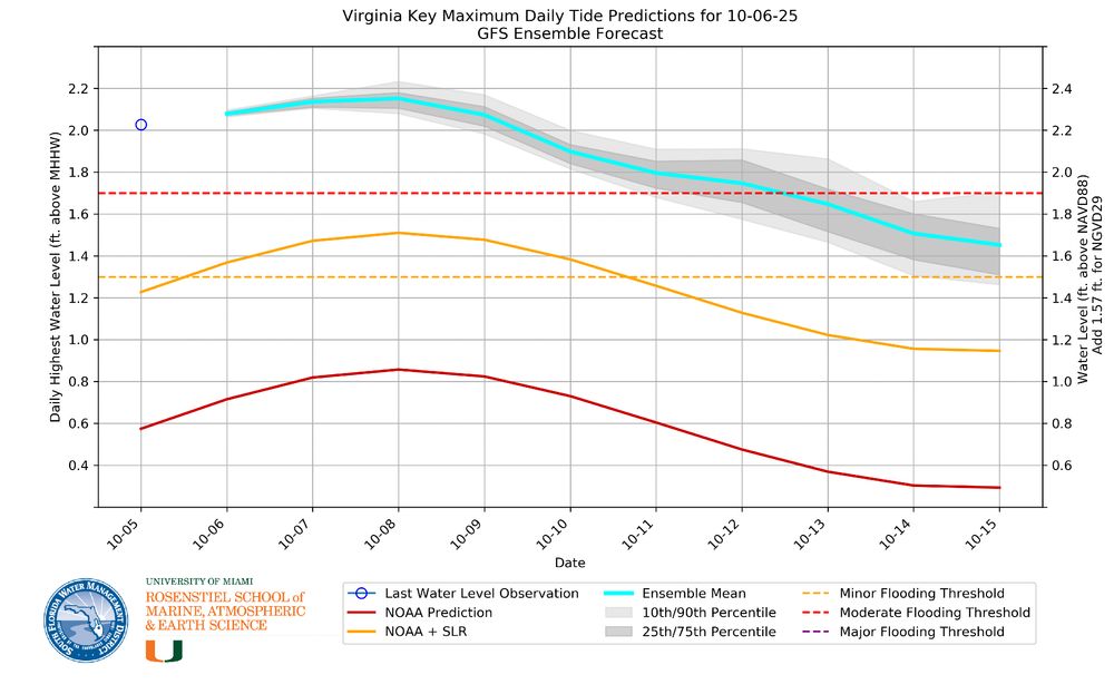
With the full moon being "largest" closest to earth this week, tides are extra high overall - even if local weather is pleasant. The impacts are most pronounced in places like Florida.

October 8, 2025 at 2:57 AM
With the full moon being "largest" closest to earth this week, tides are extra high overall - even if local weather is pleasant. The impacts are most pronounced in places like Florida.
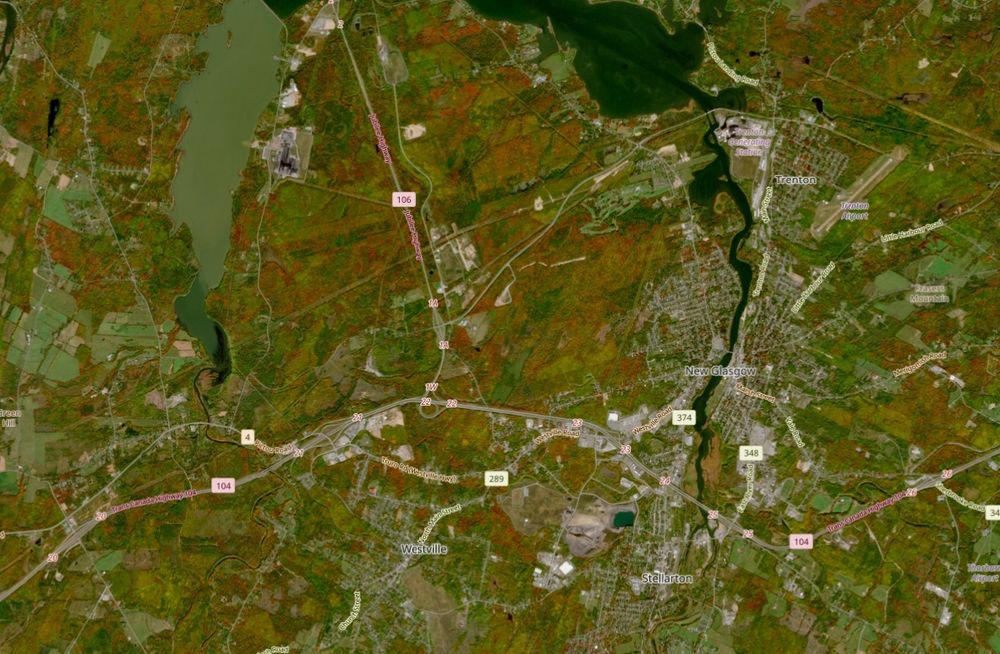
High-resolution Sentinel satellite views over New Glasgow and area - two cloudless snapshots: Aug 17 and today, Oct 6 showcasing the fall colors.

October 7, 2025 at 12:43 AM
High-resolution Sentinel satellite views over New Glasgow and area - two cloudless snapshots: Aug 17 and today, Oct 6 showcasing the fall colors.