


Chris Fogarty, PhD
@cyclone-fogarty.bsky.social
Meteorologist/Manager at the Canadian Hurricane Centre
@ECCC_CHC
| Tropical cyclone (hurricane) and many weather related topics | postings are own not employer
@ECCC_CHC
| Tropical cyclone (hurricane) and many weather related topics | postings are own not employer


Detailed VIS satellite animation of today's deep cyclone south of Newfoundland - may take a bit to load the loop. rammb-slider.cira.colostate.edu?sat=goes-19&... #nswx #pewx #nlwx

November 4, 2025 at 4:25 PM
Detailed VIS satellite animation of today's deep cyclone south of Newfoundland - may take a bit to load the loop. rammb-slider.cira.colostate.edu?sat=goes-19&... #nswx #pewx #nlwx


Halloween Oct 31 day weather for Halifax: windy, wet, mild during the day then wind shift/rain ending BY evening (as of now). Winds less strong in evening. High ~16C then ~11C by late evening...surfaces will be wet. Saturday eve: drier, cooler (7-9C) #nswx

October 29, 2025 at 9:56 PM
Halloween Oct 31 day weather for Halifax: windy, wet, mild during the day then wind shift/rain ending BY evening (as of now). Winds less strong in evening. High ~16C then ~11C by late evening...surfaces will be wet. Saturday eve: drier, cooler (7-9C) #nswx
On Saturday driving over Mt Thom the blueberry fields next to the highway were beaming bright red as they usually do in late October. This and others also stand out in high-resolution satellite image.


October 28, 2025 at 1:05 AM
On Saturday driving over Mt Thom the blueberry fields next to the highway were beaming bright red as they usually do in late October. This and others also stand out in high-resolution satellite image.
Will Hurricane Melissa play any role in Atlantic Canada's weather? Still too early to know. There may be some wind/rain around Halloween even without Melissa. Here is a model prediction of the weather pattern Friday. #nswx

October 27, 2025 at 12:17 AM
Will Hurricane Melissa play any role in Atlantic Canada's weather? Still too early to know. There may be some wind/rain around Halloween even without Melissa. Here is a model prediction of the weather pattern Friday. #nswx


High-res weather model rainfall forecast from the cold front tonight (1st image) and from sea-effect cold showers in the NW winds behind it (2nd image). Some of the peak amounts may be overdone but gives an idea of pattern and areas to expect some drought relief. #nswx #pewx


October 8, 2025 at 3:28 PM
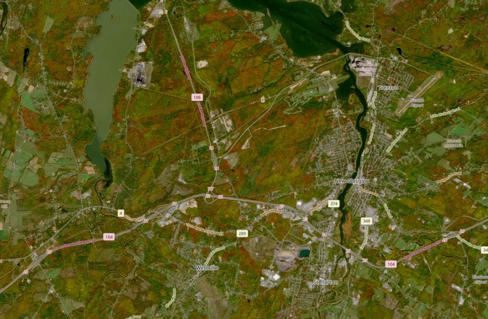
High-resolution Sentinel satellite views over New Glasgow and area - two cloudless snapshots: Aug 17 and today, Oct 6 showcasing the fall colors.

October 7, 2025 at 12:43 AM
High-resolution Sentinel satellite views over New Glasgow and area - two cloudless snapshots: Aug 17 and today, Oct 6 showcasing the fall colors.
Normal conditions before fire/foliage change (Sept 2):

October 5, 2025 at 5:39 PM
Normal conditions before fire/foliage change (Sept 2):
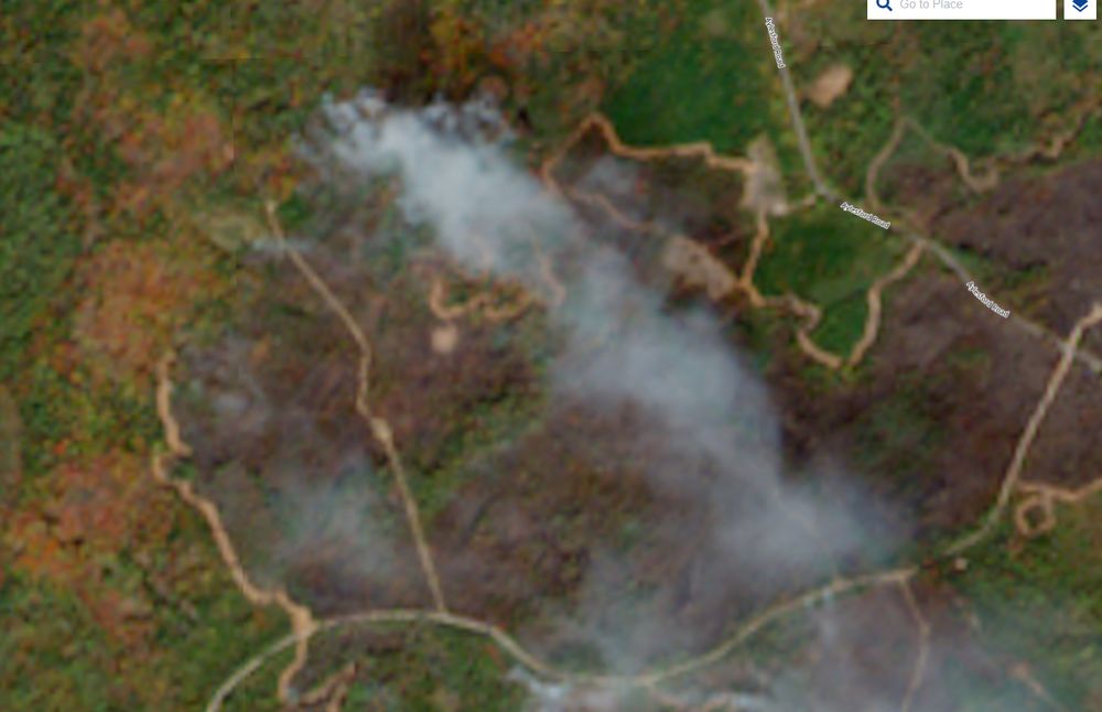
View of George Lake fire as of Saturday Oct 4. Note the fire break around edge by dozers (looks like winding logging road). Foliage color change apparent as well. #nswx

October 5, 2025 at 5:25 PM
View of George Lake fire as of Saturday Oct 4. Note the fire break around edge by dozers (looks like winding logging road). Foliage color change apparent as well. #nswx
Noticed that as well on my stroll - here late. Took a couple snaps.


October 4, 2025 at 1:45 AM
Noticed that as well on my stroll - here late. Took a couple snaps.

Cooler airmass today ... this afternoon large cumulus cloud buildup and likely showers into evening with sunny intervals. Don't be shocked if you see some small hail (ice pellets) during the showers with temperature drop below 10C. Low freezing level around 4500 ft (1300m). #nswx #pewx

October 1, 2025 at 3:00 PM


September 29, 2025 at 6:24 PM
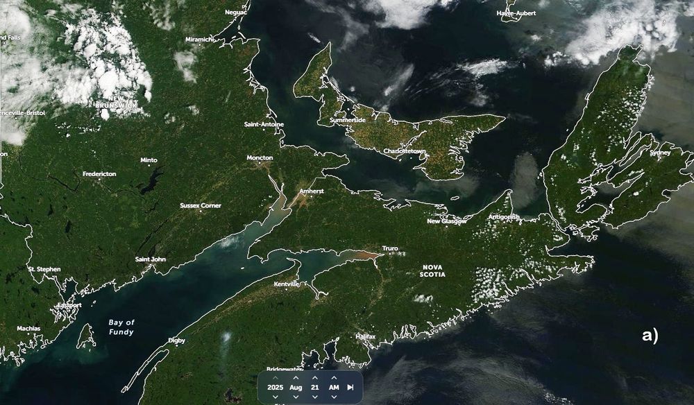
Comp of satellite imagery from a) late Aug '25 (before fall colors), b) late Sept '25 and c) late Sept '22. Presence of fall colors more prominent and earlier than normal ('22 was near normal) this year - possibly changing sooner due stress from drought and cooler/dry nights. #nswx #pewx #nbwx


September 28, 2025 at 6:16 PM
Model forecast for middle of next week showing general position and possible cloud pattern associated with Hurricane Humberto and TD9/Imelda. Atlantic Canada not expected to have to contend with these storms, but will update if that changes.


September 27, 2025 at 5:03 PM
Model forecast for middle of next week showing general position and possible cloud pattern associated with Hurricane Humberto and TD9/Imelda. Atlantic Canada not expected to have to contend with these storms, but will update if that changes.

September 26, 2025 at 6:43 PM
Chain Lake (2nd) Halifax this afternoon with water level about 1m/3ft+ below normal.

September 21, 2025 at 8:06 PM
Chain Lake (2nd) Halifax this afternoon with water level about 1m/3ft+ below normal.
September 21, 2025 at 2:00 PM
The drought has been so pronounced that the effects are discernible in satellite imagery. Here is a comparison with mid September last year. Note the yellow/brown agricultural lands compared to generally greener ones a year prior.

September 18, 2025 at 2:30 AM
The drought has been so pronounced that the effects are discernible in satellite imagery. Here is a comparison with mid September last year. Note the yellow/brown agricultural lands compared to generally greener ones a year prior.