


Black Sheep Weather
@blacksheepwx.bsky.social
Amateur meteorologist, storm spotter and chaser, and a ham radio operator.
73s de N9KDK
Video forecasts and severe weather livestreams coming on YouTube https://youtube.com/@blacksheepweather
73s de N9KDK
Video forecasts and severe weather livestreams coming on YouTube https://youtube.com/@blacksheepweather


Sat Sept 13, 2025 - 6:00pm
FORECAST - Twin Cities Area
Tonight: Mostly cloudy. Low: 67
Sunday: Fair skies. High: 89 Low: 68
Monday: Partly cloudy. 30% chance of PM showers/storms. High: 86 Low: 68
1/3
FORECAST - Twin Cities Area
Tonight: Mostly cloudy. Low: 67
Sunday: Fair skies. High: 89 Low: 68
Monday: Partly cloudy. 30% chance of PM showers/storms. High: 86 Low: 68
1/3

September 13, 2025 at 11:05 PM
Sat Sept 13, 2025 - 6:00pm
FORECAST - Twin Cities Area
Tonight: Mostly cloudy. Low: 67
Sunday: Fair skies. High: 89 Low: 68
Monday: Partly cloudy. 30% chance of PM showers/storms. High: 86 Low: 68
1/3
FORECAST - Twin Cities Area
Tonight: Mostly cloudy. Low: 67
Sunday: Fair skies. High: 89 Low: 68
Monday: Partly cloudy. 30% chance of PM showers/storms. High: 86 Low: 68
1/3
Last week was our first "faux fall"...but the long range outlooks are showing very high chances of above normal temperatures across the region.
Here is the latest 8-14 day temperature outlook for Sept 15th to 21st.
We should be in a warm stretch right through the middle of September.
Here is the latest 8-14 day temperature outlook for Sept 15th to 21st.
We should be in a warm stretch right through the middle of September.

September 10, 2025 at 2:35 AM
Last week was our first "faux fall"...but the long range outlooks are showing very high chances of above normal temperatures across the region.
Here is the latest 8-14 day temperature outlook for Sept 15th to 21st.
We should be in a warm stretch right through the middle of September.
Here is the latest 8-14 day temperature outlook for Sept 15th to 21st.
We should be in a warm stretch right through the middle of September.
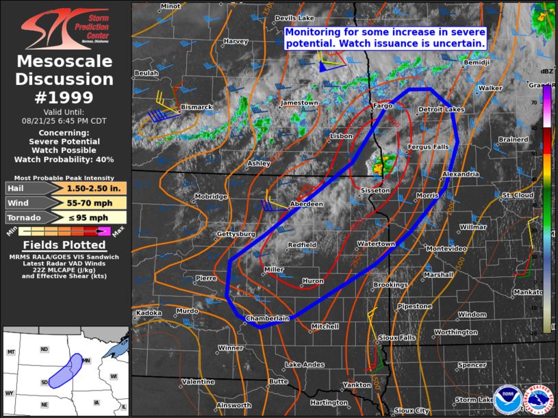
UPDATE:
Heads up from the SPC. There may be a severe thunderstorm watch in areas from Chamberlain, SD up towards Detroit Lakes, MN.
The SPC says a 40% chance but they are monitoring the area.
Heads up from the SPC. There may be a severe thunderstorm watch in areas from Chamberlain, SD up towards Detroit Lakes, MN.
The SPC says a 40% chance but they are monitoring the area.
August 21, 2025 at 10:44 PM
UPDATE:
Heads up from the SPC. There may be a severe thunderstorm watch in areas from Chamberlain, SD up towards Detroit Lakes, MN.
The SPC says a 40% chance but they are monitoring the area.
Heads up from the SPC. There may be a severe thunderstorm watch in areas from Chamberlain, SD up towards Detroit Lakes, MN.
The SPC says a 40% chance but they are monitoring the area.


July 28, 2025 at 11:33 PM
Quite clear is the potential level of severity.
SPC: Swaths of damaging winds, potentially 75-90 mph, a few tornadoes and isolated large hail will all be possible.
A MODERATE RISK of severe storms is posted south and west from Sisseton SD to Willmar, Fairbault, and then Harmony, MN.
4/5
SPC: Swaths of damaging winds, potentially 75-90 mph, a few tornadoes and isolated large hail will all be possible.
A MODERATE RISK of severe storms is posted south and west from Sisseton SD to Willmar, Fairbault, and then Harmony, MN.
4/5


July 28, 2025 at 6:06 PM
Quite clear is the potential level of severity.
SPC: Swaths of damaging winds, potentially 75-90 mph, a few tornadoes and isolated large hail will all be possible.
A MODERATE RISK of severe storms is posted south and west from Sisseton SD to Willmar, Fairbault, and then Harmony, MN.
4/5
SPC: Swaths of damaging winds, potentially 75-90 mph, a few tornadoes and isolated large hail will all be possible.
A MODERATE RISK of severe storms is posted south and west from Sisseton SD to Willmar, Fairbault, and then Harmony, MN.
4/5
For this afternoon, southerly winds will continue to pump in hot and humid air. *IF* storms form, some storms could be severe primarily with large hail (up to 2"), strong winds, and a slight chance of tornadoes.
2/7
2/7

July 22, 2025 at 4:43 PM
For this afternoon, southerly winds will continue to pump in hot and humid air. *IF* storms form, some storms could be severe primarily with large hail (up to 2"), strong winds, and a slight chance of tornadoes.
2/7
2/7
Current radar looks like this:

July 19, 2025 at 1:32 AM
Current radar looks like this:
The area covered by the new Severe Thunderstorm Watch until 7pm.

June 2, 2025 at 7:51 PM
The area covered by the new Severe Thunderstorm Watch until 7pm.
Discussion for 29 May 2025 1530CDT
Scattered showers/storms continue through the evening. Fri sees mostly clear skies and a steady warm up in temps into Mon which could see highs in the low 90s.
Models are indicating severe storms possible next Tue (see Day 5 outlook).
#mnwx #wiwx
Scattered showers/storms continue through the evening. Fri sees mostly clear skies and a steady warm up in temps into Mon which could see highs in the low 90s.
Models are indicating severe storms possible next Tue (see Day 5 outlook).
#mnwx #wiwx

May 29, 2025 at 8:47 PM
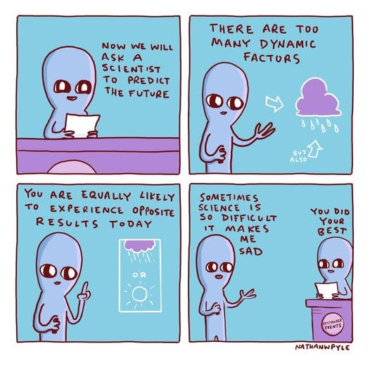
And speaking of forecasts:
Nathan W Pyle released this comic and it hit home:
Nathan W Pyle released this comic and it hit home:
May 22, 2025 at 8:26 PM
And speaking of forecasts:
Nathan W Pyle released this comic and it hit home:
Nathan W Pyle released this comic and it hit home:
Discussion:
Severe wx is looking more likely on Thu PM. All modes of severe wx are possible. The highest wind/hail risk is in the eastern metro into western WI but are possible across the entire area with this area in an ENHANCED risk. The highest tornado risk is in western WI.
#mnwx #wiwx
Severe wx is looking more likely on Thu PM. All modes of severe wx are possible. The highest wind/hail risk is in the eastern metro into western WI but are possible across the entire area with this area in an ENHANCED risk. The highest tornado risk is in western WI.
#mnwx #wiwx
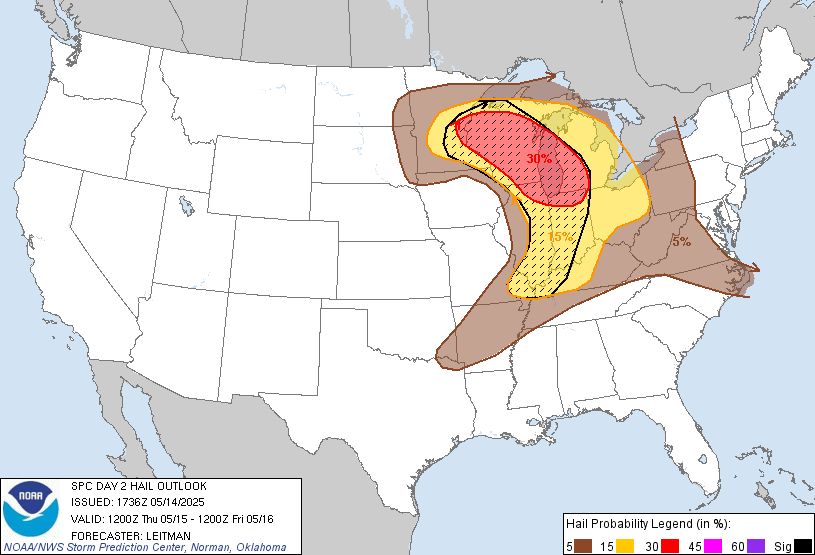


May 14, 2025 at 6:46 PM
JUST ISSUED:
A TORNADO watch for Minnesota west of a line from St. Cloud to Mankato to the IA border. The watch expires at 8pm.
The 7 (MN) County metro is *not* included in this watch at this time.
See the attached image for the exact outline of the watch.
A TORNADO watch for Minnesota west of a line from St. Cloud to Mankato to the IA border. The watch expires at 8pm.
The 7 (MN) County metro is *not* included in this watch at this time.
See the attached image for the exact outline of the watch.

April 28, 2025 at 5:35 PM
JUST ISSUED:
A TORNADO watch for Minnesota west of a line from St. Cloud to Mankato to the IA border. The watch expires at 8pm.
The 7 (MN) County metro is *not* included in this watch at this time.
See the attached image for the exact outline of the watch.
A TORNADO watch for Minnesota west of a line from St. Cloud to Mankato to the IA border. The watch expires at 8pm.
The 7 (MN) County metro is *not* included in this watch at this time.
See the attached image for the exact outline of the watch.
Radar shows the line of storms bubbling up from Sioux Falls SD and north towards Canby. The Satellite image shows the cloud cover breaking up from Willmar to Fairmont and west.
We are loading the atmosphere with more storm fuel.
We are loading the atmosphere with more storm fuel.


April 28, 2025 at 5:32 PM
Radar shows the line of storms bubbling up from Sioux Falls SD and north towards Canby. The Satellite image shows the cloud cover breaking up from Willmar to Fairmont and west.
We are loading the atmosphere with more storm fuel.
We are loading the atmosphere with more storm fuel.
Our first storms of the day have formed.

April 17, 2025 at 6:41 PM
Our first storms of the day have formed.
I had to take a break from staring at data to get out and enjoy our 75 degree weather.


March 14, 2025 at 11:07 PM
I had to take a break from staring at data to get out and enjoy our 75 degree weather.
The current status of watches, advisories, and the severe thunderstorm outlook as of noon (12pm/1700 UTC).

March 14, 2025 at 6:03 PM
The current status of watches, advisories, and the severe thunderstorm outlook as of noon (12pm/1700 UTC).
Thanks to the NWS in Chanhassen for the graphic!

March 7, 2025 at 1:20 AM
Thanks to the NWS in Chanhassen for the graphic!
Evening Update: A sunny but chilly day today but it's all smooth sailing from here!
Mostly sunny skies through the week and a big above normal day on Monday.
I'll be curious to see how many 'mental health day'/'spring fever' days are taken on Monday.
#mnwx #mspwx #blacksheepwx
Mostly sunny skies through the week and a big above normal day on Monday.
I'll be curious to see how many 'mental health day'/'spring fever' days are taken on Monday.
#mnwx #mspwx #blacksheepwx

March 7, 2025 at 1:13 AM
Evening Update: A sunny but chilly day today but it's all smooth sailing from here!
Mostly sunny skies through the week and a big above normal day on Monday.
I'll be curious to see how many 'mental health day'/'spring fever' days are taken on Monday.
#mnwx #mspwx #blacksheepwx
Mostly sunny skies through the week and a big above normal day on Monday.
I'll be curious to see how many 'mental health day'/'spring fever' days are taken on Monday.
#mnwx #mspwx #blacksheepwx
The snow is upon us and remain throughout the afternoon. The heaviest snow will remain south of the Minnesota River.
Accumulations should be 1-3" except in the "winning" area south of the Minnesota River which could seeing local 4-5" totals.
#mnwx #wiwx #mspwx #twincitieswx #blacksheepwx
Accumulations should be 1-3" except in the "winning" area south of the Minnesota River which could seeing local 4-5" totals.
#mnwx #wiwx #mspwx #twincitieswx #blacksheepwx

February 14, 2025 at 8:35 PM
The snow is upon us and remain throughout the afternoon. The heaviest snow will remain south of the Minnesota River.
Accumulations should be 1-3" except in the "winning" area south of the Minnesota River which could seeing local 4-5" totals.
#mnwx #wiwx #mspwx #twincitieswx #blacksheepwx
Accumulations should be 1-3" except in the "winning" area south of the Minnesota River which could seeing local 4-5" totals.
#mnwx #wiwx #mspwx #twincitieswx #blacksheepwx
What we call "Severe Clear".
Not a cloud in the sky, temperatures around +20F and light winds. Honestly, it's not a bad day to get outside, avoid a bar or anywhere else showing a certain sporting event and enjoy a walk or hike in your favorite slice of Nature. #mnwx #mspwx #blacksheepwx
Not a cloud in the sky, temperatures around +20F and light winds. Honestly, it's not a bad day to get outside, avoid a bar or anywhere else showing a certain sporting event and enjoy a walk or hike in your favorite slice of Nature. #mnwx #mspwx #blacksheepwx

February 9, 2025 at 10:12 PM
What we call "Severe Clear".
Not a cloud in the sky, temperatures around +20F and light winds. Honestly, it's not a bad day to get outside, avoid a bar or anywhere else showing a certain sporting event and enjoy a walk or hike in your favorite slice of Nature. #mnwx #mspwx #blacksheepwx
Not a cloud in the sky, temperatures around +20F and light winds. Honestly, it's not a bad day to get outside, avoid a bar or anywhere else showing a certain sporting event and enjoy a walk or hike in your favorite slice of Nature. #mnwx #mspwx #blacksheepwx