


Rudo
@rudokemper.com
Geographer & technologist working on digital tools for participatory mapping and data sovereignty.
Also on Mastodon: fosstodon.org/@rudo
Also on Mastodon: fosstodon.org/@rudo
I had the opportunity to work on generating some stream data in #QGIS for a partner in the Ecuadorian Amazon today. I had forgotten how much fun it is to do remote sensing stuff 🙂

October 7, 2025 at 6:37 PM
I had the opportunity to work on generating some stream data in #QGIS for a partner in the Ecuadorian Amazon today. I had forgotten how much fun it is to do remote sensing stuff 🙂
Reposted by Rudo

❤️ Have you shared your perspectives on the survey led by the GBIF #TaskGroup on Indigenous data governance?
This week, task group chair @1nativesoilnerd.bsky.social shared initial results of the survey at the Living Data, Living Lands event at #ClimateWeekNYC.
🔗gbif.link/Indigenous...
This week, task group chair @1nativesoilnerd.bsky.social shared initial results of the survey at the Living Data, Living Lands event at #ClimateWeekNYC.
🔗gbif.link/Indigenous...

September 26, 2025 at 8:00 AM
❤️ Have you shared your perspectives on the survey led by the GBIF #TaskGroup on Indigenous data governance?
This week, task group chair @1nativesoilnerd.bsky.social shared initial results of the survey at the Living Data, Living Lands event at #ClimateWeekNYC.
🔗gbif.link/Indigenous...
This week, task group chair @1nativesoilnerd.bsky.social shared initial results of the survey at the Living Data, Living Lands event at #ClimateWeekNYC.
🔗gbif.link/Indigenous...
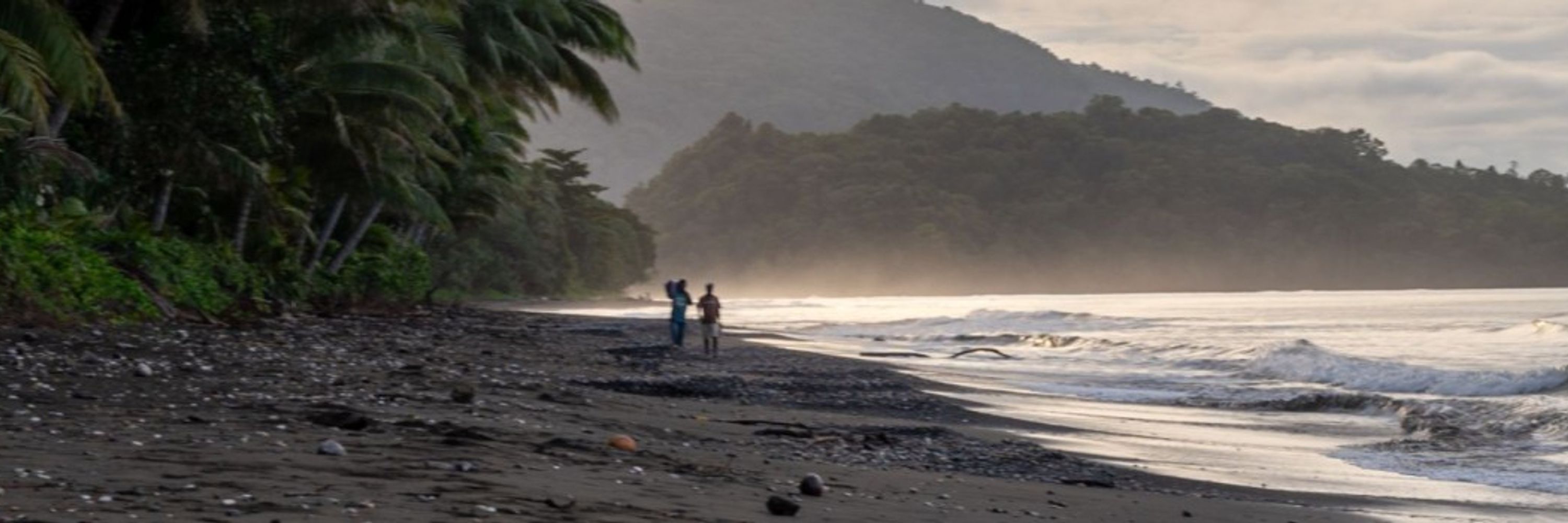
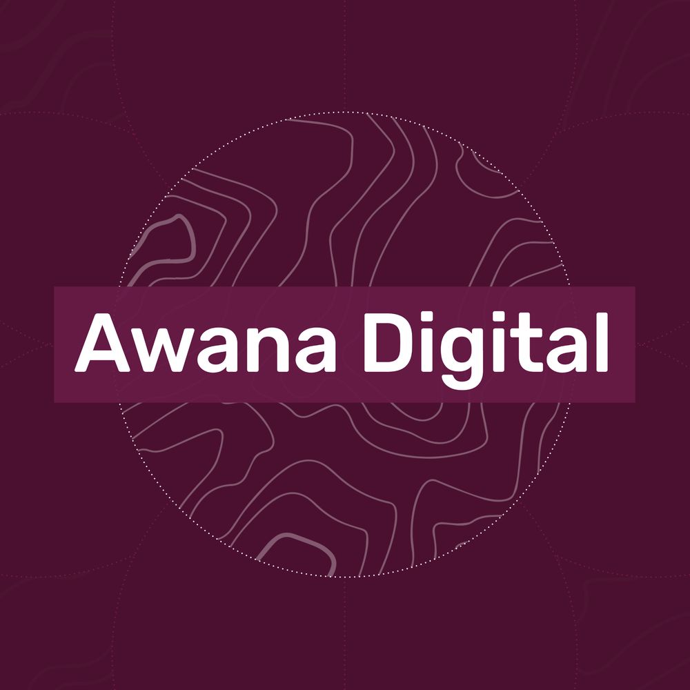
This is amazing. Do yourself a favor and check out this report from @awana.digital jam-packed with incredible community mapping impact stories and powerful visuals!
In honor of the International Day of the World's Indigenous Peoples, we’re taking a look at the impact of our tool Mapeo. Since 2016, our partners have used it to collectively map and manage over 16.8 million hectares of community lands.
Want to know more? Check out our report!
bit.ly/4lZRBKN
Want to know more? Check out our report!
bit.ly/4lZRBKN


August 7, 2025 at 3:23 PM
This is amazing. Do yourself a favor and check out this report from @awana.digital jam-packed with incredible community mapping impact stories and powerful visuals!
Given ongoing FOSS governance concerns with #OrganicMaps, I modified my "Convert Google Maps saved places" tool to explicitly support @comaps.app instead: rudokemper.github.io/google-maps-...
Convert Google Maps saved places to CoMaps
rudokemper.github.io
July 13, 2025 at 5:15 PM
Given ongoing FOSS governance concerns with #OrganicMaps, I modified my "Convert Google Maps saved places" tool to explicitly support @comaps.app instead: rudokemper.github.io/google-maps-...
Sharing this technical blog post about our use of the FOSS data orchestration engine Windmill to build and manage backend data workflows for Indigenous community organizations! www.windmill.dev/blog/conserv...
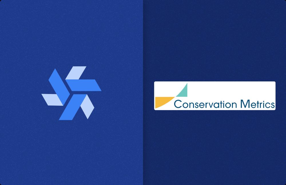
Windmill for Supporting Indigenous Communities - Conservation Metrics Case Study | Windmill
This is a testimonial from Rudo Kemper from Conservation Metrics about how Windmill has helped them build open-source software for indigenous communities, enabling automated data processing and critic...
www.windmill.dev
June 4, 2025 at 3:30 PM
Sharing this technical blog post about our use of the FOSS data orchestration engine Windmill to build and manage backend data workflows for Indigenous community organizations! www.windmill.dev/blog/conserv...
Delighted to announce a hiring opp at Conservation Metrics!
Come join our team in building a FOSS data sovereignty platform for communities to securely centralize, access, and derive insights from their data, stored on premises which they own entirely.
conservationmetrics.com/hiring-fulls...
Come join our team in building a FOSS data sovereignty platform for communities to securely centralize, access, and derive insights from their data, stored on premises which they own entirely.
conservationmetrics.com/hiring-fulls...
May 12, 2025 at 8:33 PM
Delighted to announce a hiring opp at Conservation Metrics!
Come join our team in building a FOSS data sovereignty platform for communities to securely centralize, access, and derive insights from their data, stored on premises which they own entirely.
conservationmetrics.com/hiring-fulls...
Come join our team in building a FOSS data sovereignty platform for communities to securely centralize, access, and derive insights from their data, stored on premises which they own entirely.
conservationmetrics.com/hiring-fulls...
Check out this great piece by Tanya Ruka and Victor Temprano about how and why @nativeland.bsky.social is centering Indigenous data sovereignty in the terms of service of our API!
nativeland.substack.com/p/native-lan...
nativeland.substack.com/p/native-lan...
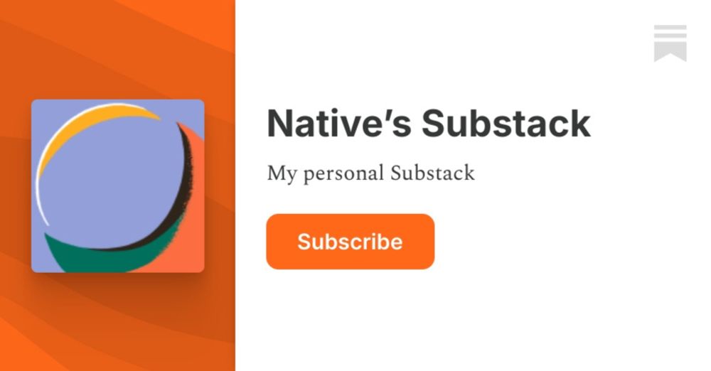
Native Land Digital API: Indigenous Data Sovereignty Treaty & Agreement - Important Update.
Kia ora koutou!
nativeland.substack.com
May 1, 2025 at 4:24 AM
Check out this great piece by Tanya Ruka and Victor Temprano about how and why @nativeland.bsky.social is centering Indigenous data sovereignty in the terms of service of our API!
nativeland.substack.com/p/native-lan...
nativeland.substack.com/p/native-lan...
GIS folks: is there a viable #QGIS plugin for freehand drawing features that will work in 3.x.x?
It looks like "BeePen" is only good for annotations, and "Freehand Editing" was last updated 12 years ago.
If not, would there be interest in one?
#GISChat @qgis.fosstodon.org.ap.brid.gy
It looks like "BeePen" is only good for annotations, and "Freehand Editing" was last updated 12 years ago.
If not, would there be interest in one?
#GISChat @qgis.fosstodon.org.ap.brid.gy
April 8, 2025 at 4:38 PM
GIS folks: is there a viable #QGIS plugin for freehand drawing features that will work in 3.x.x?
It looks like "BeePen" is only good for annotations, and "Freehand Editing" was last updated 12 years ago.
If not, would there be interest in one?
#GISChat @qgis.fosstodon.org.ap.brid.gy
It looks like "BeePen" is only good for annotations, and "Freehand Editing" was last updated 12 years ago.
If not, would there be interest in one?
#GISChat @qgis.fosstodon.org.ap.brid.gy
Reposted by Rudo

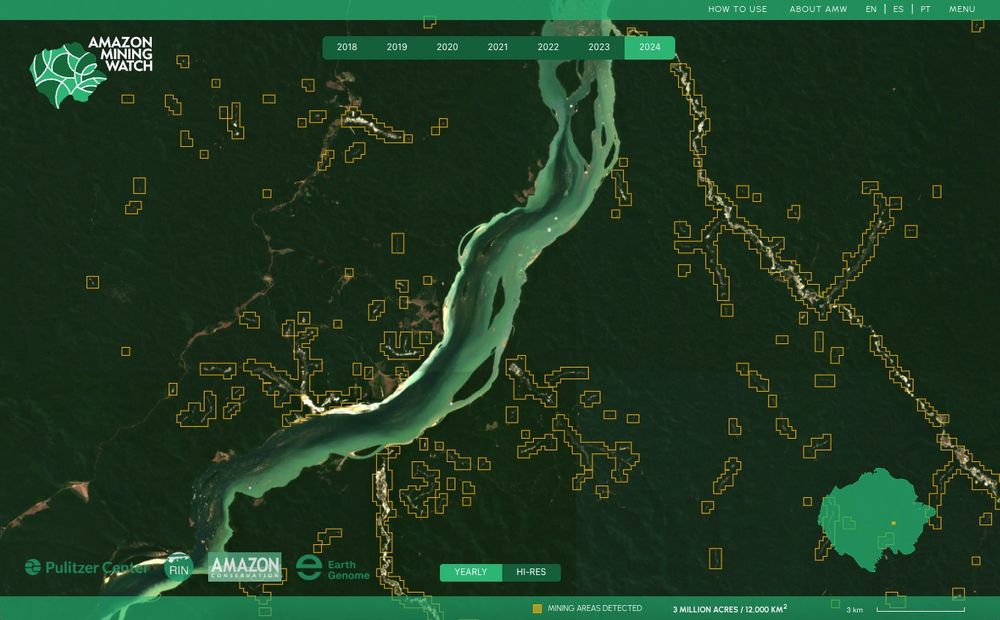
Amazon Mining Watch is now available with 2024 data, to detect and compare mining driven environmental harm across the Amazon.
amazonminingwatch.org/en
amazonminingwatch.org/en
March 20, 2025 at 2:06 PM
Amazon Mining Watch is now available with 2024 data, to detect and compare mining driven environmental harm across the Amazon.
amazonminingwatch.org/en
amazonminingwatch.org/en
Reposted by Rudo
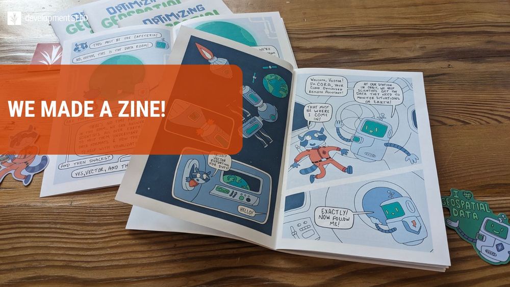
A project I've been working on for the last 6 months. I feel really strongly about making geospatial technology and data available and understood by as many people as possible. And that requires getting creative with the ways we share information. This is my small contribution to that effort.
🚀 We made a zine!
"𝗢𝗽𝘁𝗶𝗺𝗶𝘇𝗶𝗻𝗴 𝗚𝗲𝗼𝘀𝗽𝗮𝘁𝗶𝗮𝗹 𝗗𝗮𝘁𝗮 𝗳𝗼𝗿 𝘁𝗵𝗲 𝗖𝗹𝗼𝘂𝗱: 𝗔 𝗭𝗶𝗻𝗲 𝗘𝘅𝗽𝗹𝗼𝗿𝗶𝗻𝗴 𝗖𝗼𝗺𝗺𝗼𝗻 𝗙𝗼𝗿𝗺𝗮𝘁𝘀" is our answer to the notion that Big Ideas are best shared through accessible, creative, and impactful formats.
🔗 ds.io/cloud-native...
by @kiricarini.com & @gusbusdraws.bsky.social
"𝗢𝗽𝘁𝗶𝗺𝗶𝘇𝗶𝗻𝗴 𝗚𝗲𝗼𝘀𝗽𝗮𝘁𝗶𝗮𝗹 𝗗𝗮𝘁𝗮 𝗳𝗼𝗿 𝘁𝗵𝗲 𝗖𝗹𝗼𝘂𝗱: 𝗔 𝗭𝗶𝗻𝗲 𝗘𝘅𝗽𝗹𝗼𝗿𝗶𝗻𝗴 𝗖𝗼𝗺𝗺𝗼𝗻 𝗙𝗼𝗿𝗺𝗮𝘁𝘀" is our answer to the notion that Big Ideas are best shared through accessible, creative, and impactful formats.
🔗 ds.io/cloud-native...
by @kiricarini.com & @gusbusdraws.bsky.social
February 20, 2025 at 2:45 PM
A project I've been working on for the last 6 months. I feel really strongly about making geospatial technology and data available and understood by as many people as possible. And that requires getting creative with the ways we share information. This is my small contribution to that effort.
Reposted by Rudo

What if you could ask a map a question—and get a real, reliable answer?
We’ve been exploring how LLMs can make geospatial data more accessible by translating natural language into structured queries. But AI alone isn’t enough—trusted data sources and human oversight are key.
🔗 ds.io/language-in...
We’ve been exploring how LLMs can make geospatial data more accessible by translating natural language into structured queries. But AI alone isn’t enough—trusted data sources and human oversight are key.
🔗 ds.io/language-in...

Language Interfaces for Maps — Development Seed
When maps understand what you mean, not just what you click
ds.io
February 11, 2025 at 7:03 PM
What if you could ask a map a question—and get a real, reliable answer?
We’ve been exploring how LLMs can make geospatial data more accessible by translating natural language into structured queries. But AI alone isn’t enough—trusted data sources and human oversight are key.
🔗 ds.io/language-in...
We’ve been exploring how LLMs can make geospatial data more accessible by translating natural language into structured queries. But AI alone isn’t enough—trusted data sources and human oversight are key.
🔗 ds.io/language-in...
Reposted by Rudo
Just in case you had missed this...
By Friday, the landing pages on the United States Forest Service website for key resources, research and adaptation tools had gone dark, leaving behind an error message or just a single line: “You are not authorized to access this page.” 🌐🧪🌎
By Friday, the landing pages on the United States Forest Service website for key resources, research and adaptation tools had gone dark, leaving behind an error message or just a single line: “You are not authorized to access this page.” 🌐🧪🌎
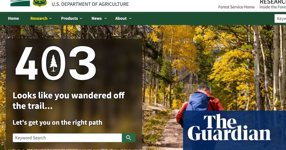
Trump orders USDA to take down websites referencing climate crisis
Forest service website among many sites affected as agencies scramble to comply with president’s orders
www.theguardian.com
February 1, 2025 at 7:13 PM
Just in case you had missed this...
By Friday, the landing pages on the United States Forest Service website for key resources, research and adaptation tools had gone dark, leaving behind an error message or just a single line: “You are not authorized to access this page.” 🌐🧪🌎
By Friday, the landing pages on the United States Forest Service website for key resources, research and adaptation tools had gone dark, leaving behind an error message or just a single line: “You are not authorized to access this page.” 🌐🧪🌎
Reposted by Rudo
Come work with me on some cutting-edge decentralised tech with real-world applications that is directly helping communities around the world protect biodiversity and fight deforestation.
🌱We are looking for a Senior Backend Developer with at least 5 years experience to join our small, collaborative, remote team.
📢Are you interested in using your peer-to-peer skills to build tools for social and environmental justice?
👉Take a look: bit.ly/3OXiDDG
📢Are you interested in using your peer-to-peer skills to build tools for social and environmental justice?
👉Take a look: bit.ly/3OXiDDG

January 23, 2025 at 6:41 PM
Come work with me on some cutting-edge decentralised tech with real-world applications that is directly helping communities around the world protect biodiversity and fight deforestation.
Reposted by Rudo
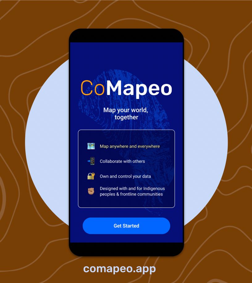
.🥳 Have you tried CoMapeo yet? We are excited for you to try our next-gen territorial monitoring & mapping tool, co-designed with #EarthDefenders.
🌱Download it and map your world, together. New features coming soon!
👉🏾Find it on the Playstore or visit comapeo.app
🌱Download it and map your world, together. New features coming soon!
👉🏾Find it on the Playstore or visit comapeo.app
January 23, 2025 at 4:19 PM
.🥳 Have you tried CoMapeo yet? We are excited for you to try our next-gen territorial monitoring & mapping tool, co-designed with #EarthDefenders.
🌱Download it and map your world, together. New features coming soon!
👉🏾Find it on the Playstore or visit comapeo.app
🌱Download it and map your world, together. New features coming soon!
👉🏾Find it on the Playstore or visit comapeo.app
Check out this article about some great territorial defense work being done by the Krahô community with support by @luandro.bsky.social and @awana.digital in Brazil

Indigenous women from Krahô communities in Brazil’s Tocantins state have formed a surveillance group to protect their ancestral territory from invaders.
They plan and implement territorial protection actions based on Krahô traditions and ways of life.
Read:
They plan and implement territorial protection actions based on Krahô traditions and ways of life.
Read:

Krahô women lead Indigenous guard to protect territory in Brazil
Across South America, Indigenous communities have often considered territorial protection to be the main responsibility of men, while women typically assume roles as caretakers of the household, famil...
news.mongabay.com
January 14, 2025 at 4:06 PM
Check out this article about some great territorial defense work being done by the Krahô community with support by @luandro.bsky.social and @awana.digital in Brazil
Reposted by Rudo

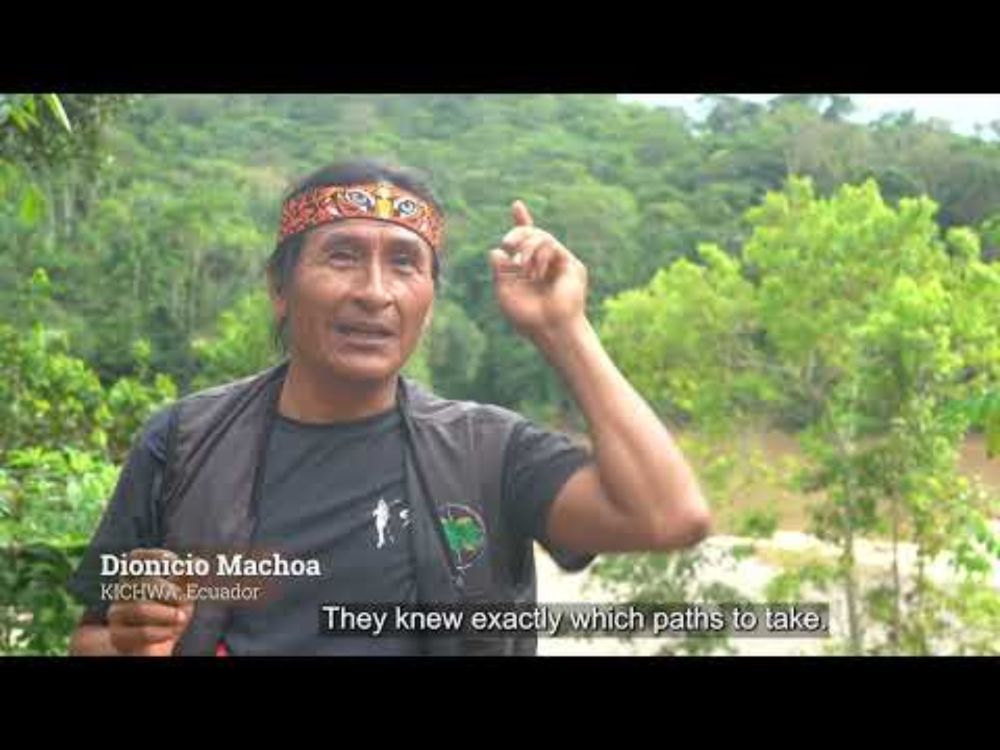
This short film explores how Indigenous communities are combining ancestral wisdom with cutting-edge technology to map and monitor their territories. From ancient traditions to modern tools, these approaches can help protect their biodiversity and heritage. @nature.org
Mapping and Monitoring in Indigenous Territories (English)
YouTube video by LifeMosaic
www.youtube.com
January 10, 2025 at 1:02 AM
This short film explores how Indigenous communities are combining ancestral wisdom with cutting-edge technology to map and monitor their territories. From ancient traditions to modern tools, these approaches can help protect their biodiversity and heritage. @nature.org
Reposted by Rudo
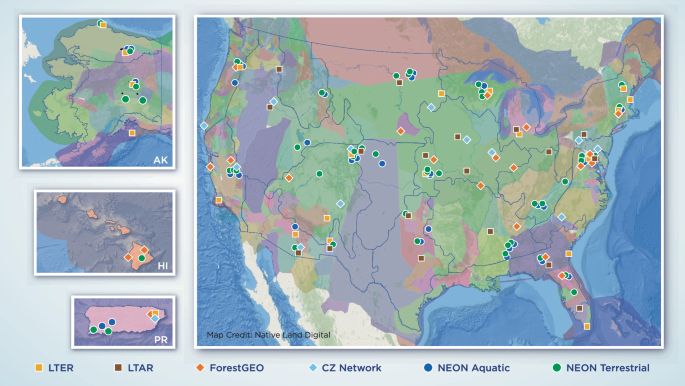
New publication alert! Check out our paper on the “Governance of Indigenous data in open Earth systems science” co- led by myself and Dr. Katie Jones. www.nature.com/articles/s41...
Governance of Indigenous data in open earth systems science - Nature Communications
Using the National Ecological Observatory Network (NEON) as an example, this perspective discusses actions that recognize the sovereign rights of Indigenous Peoples and support better research across ...
www.nature.com
January 10, 2025 at 7:00 PM
New publication alert! Check out our paper on the “Governance of Indigenous data in open Earth systems science” co- led by myself and Dr. Katie Jones. www.nature.com/articles/s41...
I make a thingy that holds community stuff, keeps it safe, and goes “hey, look!” if something weird happens.


December 31, 2024 at 1:17 PM
I make a thingy that holds community stuff, keeps it safe, and goes “hey, look!” if something weird happens.
Reposted by Rudo

Today, I got this email: "Congratulations on the successful approval by the ICA Executive Committee of your proposed new working group on #ParticipatoryMapping " Let's start the fun/work on #PGIS #PPGIS #Pmaping # participation begin! Want to join? DM me! @oliverescobar.bsky.social
December 18, 2024 at 12:12 PM
Today, I got this email: "Congratulations on the successful approval by the ICA Executive Committee of your proposed new working group on #ParticipatoryMapping " Let's start the fun/work on #PGIS #PPGIS #Pmaping # participation begin! Want to join? DM me! @oliverescobar.bsky.social
⚠️ Nerdy post ahead
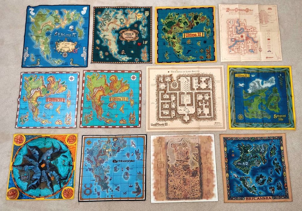
When I was young, one of my favorite PC game series was Ultima by @richardgarriott.bsky.social. I loved the world-building and philosophical aspects, and I actually learned a lot of English from playing them.
And then there were the maps; both in-game, and these physical copies.
When I was young, one of my favorite PC game series was Ultima by @richardgarriott.bsky.social. I loved the world-building and philosophical aspects, and I actually learned a lot of English from playing them.
And then there were the maps; both in-game, and these physical copies.
December 19, 2024 at 2:34 AM
⚠️ Nerdy post ahead
When I was young, one of my favorite PC game series was Ultima by @richardgarriott.bsky.social. I loved the world-building and philosophical aspects, and I actually learned a lot of English from playing them.
And then there were the maps; both in-game, and these physical copies.
When I was young, one of my favorite PC game series was Ultima by @richardgarriott.bsky.social. I loved the world-building and philosophical aspects, and I actually learned a lot of English from playing them.
And then there were the maps; both in-game, and these physical copies.
Reposted by Rudo
The PMTiles MapLibre GL JS plugin supports now tile pyramids with multiple maxzooms. That's nice when you want to put for example z14 data for Switzerland and z8 data for the rest of the world into one .pmtiles file.
Thanks @bdon.org for working on this...
github.com/protomaps/PM...
Thanks @bdon.org for working on this...
github.com/protomaps/PM...

js: maplibre protocol has option to throw on missing tile [#321] by bdon · Pull Request #505 · protomaps/PMTiles
github.com
December 15, 2024 at 8:21 PM
The PMTiles MapLibre GL JS plugin supports now tile pyramids with multiple maxzooms. That's nice when you want to put for example z14 data for Switzerland and z8 data for the rest of the world into one .pmtiles file.
Thanks @bdon.org for working on this...
github.com/protomaps/PM...
Thanks @bdon.org for working on this...
github.com/protomaps/PM...
This methodology for social mapping from UCL is a really interesting case study in meeting people where they are in terms of tech they use daily.
Should we be worried about storing potentially sensitive place data on Meta servers, though?
tinyurl.com/ucl-kapta
Should we be worried about storing potentially sensitive place data on Meta servers, though?
tinyurl.com/ucl-kapta

Is this the first-ever WhatsApp Map?
Researchers from the UCL Department of Geography introduce WhatsApp Maps, a pioneering approach that empowers communities to actively contribute to mapping through trusted digital networks.
tinyurl.com
December 9, 2024 at 1:07 PM
This methodology for social mapping from UCL is a really interesting case study in meeting people where they are in terms of tech they use daily.
Should we be worried about storing potentially sensitive place data on Meta servers, though?
tinyurl.com/ucl-kapta
Should we be worried about storing potentially sensitive place data on Meta servers, though?
tinyurl.com/ucl-kapta
A conversation with @johnwbryant.bsky.social made me realize how #QGIS plays a somewhat underappreciated role in all of our work supporting Indigenous communities in participatory mapping. So I'd like to shout out QGIS for being an amazing FOSS tool that we benefit from daily!
Captions in alt text.
Captions in alt text.
![QGIS used by the Ogiek of Mount Elgon in Kenya.
"Using two forms of technology (one very new and the other very old) to validate the spatial data collected using Mapeo — a computer mouse and a stick (here wielded by Richard Kiara). [Photo credit: Rudo Kemper]"
Source: https://terralingua.org/langscape_articles/the-wealth-of-our-lands-celebrating-boititap-korenyo-with-the-ogiek-of-mount-elgon-kenya/](https://cdn.bsky.app/img/feed_thumbnail/plain/did:plc:7r6axz7ik7xi3kzqn2sjp5sx/bafkreibfk2q7sftujjbimurxbbqhwzcllrvqf5xj3xgvra3ip6xatxiluq@jpeg)
![GIS used by the Maasai of Ngorongoro in Tanzania.
"'We have been fighting for so long but we haven't used the right tools to help us achieve what we want, it's about time that we can use these kinds of tools to help us for our benefit and future generations. We now have the tool Mapeo to mark our land of Ngorongoro' testimony by Mapeo training participant. [Photo credit: María Alvarez Malvido]"
Source: https://awana.digital/blog/ngorongoro-is-not-replaceable-the-maasai-community-mapping-in-the-face-of-forced-evictions-and-fortress-conservation-policies](https://cdn.bsky.app/img/feed_thumbnail/plain/did:plc:7r6axz7ik7xi3kzqn2sjp5sx/bafkreifiajpi23l73zc4xpjcbd2zt2vcliuimplezeriltplrffihavyi4@jpeg)
November 25, 2024 at 10:32 AM
A conversation with @johnwbryant.bsky.social made me realize how #QGIS plays a somewhat underappreciated role in all of our work supporting Indigenous communities in participatory mapping. So I'd like to shout out QGIS for being an amazing FOSS tool that we benefit from daily!
Captions in alt text.
Captions in alt text.
Reposted by Rudo
Where the bsky Rights of Nature people at? Had this posted on the other site, but the Rappahannock Tribe of VA has became the first tribal nation in the US to adopt a Tribal Constitution that recognizes the constitutional rights of nature.
nativenewsonline.net/sovereignty/...
nativenewsonline.net/sovereignty/...

Rappahannock Tribal Constitution Recognizes the Rights of the Rappahannock River
In a historic tribal-wide vote, the Rappahannock Tribe in Virginia has become the first tribal nation in the U.S. to adopt a Tribal Constitution that recognizes the constitutional rights of nature.
nativenewsonline.net
November 20, 2024 at 7:28 PM
Where the bsky Rights of Nature people at? Had this posted on the other site, but the Rappahannock Tribe of VA has became the first tribal nation in the US to adopt a Tribal Constitution that recognizes the constitutional rights of nature.
nativenewsonline.net/sovereignty/...
nativenewsonline.net/sovereignty/...
Reposted by Rudo

I created a #StarterPack for folks who work with technology in conservation and ecology. This is not an exhaustive list so please let me know if I forgot anyone or if you would like to be included! I am excited for this community to grow here! @wildlabsnet.bsky.social
go.bsky.app/8HJvopG
go.bsky.app/8HJvopG
November 21, 2024 at 5:52 PM
I created a #StarterPack for folks who work with technology in conservation and ecology. This is not an exhaustive list so please let me know if I forgot anyone or if you would like to be included! I am excited for this community to grow here! @wildlabsnet.bsky.social
go.bsky.app/8HJvopG
go.bsky.app/8HJvopG