


Rudo
@rudokemper.com
Geographer & technologist working on digital tools for participatory mapping and data sovereignty.
Also on Mastodon: fosstodon.org/@rudo
Also on Mastodon: fosstodon.org/@rudo
I had the opportunity to work on generating some stream data in #QGIS for a partner in the Ecuadorian Amazon today. I had forgotten how much fun it is to do remote sensing stuff 🙂

October 7, 2025 at 6:37 PM
I had the opportunity to work on generating some stream data in #QGIS for a partner in the Ecuadorian Amazon today. I had forgotten how much fun it is to do remote sensing stuff 🙂
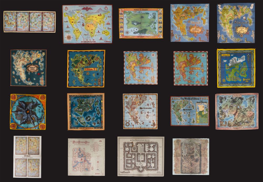
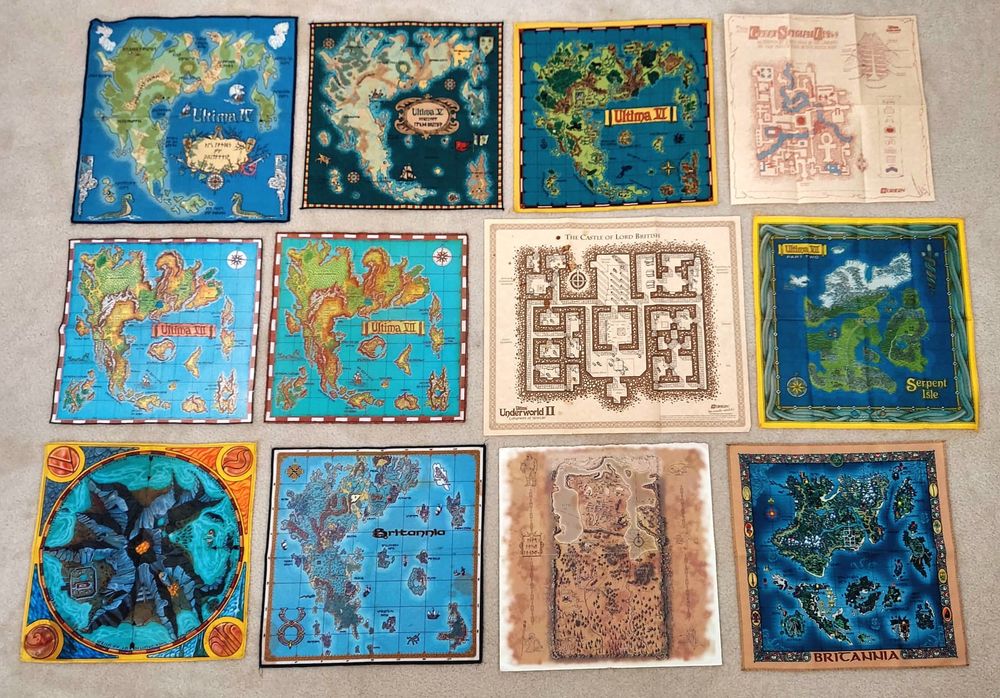
I think I ended up completing my collection of cloth #Ultima maps, plus the map for Shroud of the Avatar which is actually quite beautiful! 🗺️
High resolution: www.easyzoom.com/embed/32d1e3...
@richardgarriott.bsky.social am I missing anything essential? 😄
High resolution: www.easyzoom.com/embed/32d1e3...
@richardgarriott.bsky.social am I missing anything essential? 😄
March 20, 2025 at 11:54 PM
I think I ended up completing my collection of cloth #Ultima maps, plus the map for Shroud of the Avatar which is actually quite beautiful! 🗺️
High resolution: www.easyzoom.com/embed/32d1e3...
@richardgarriott.bsky.social am I missing anything essential? 😄
High resolution: www.easyzoom.com/embed/32d1e3...
@richardgarriott.bsky.social am I missing anything essential? 😄
⚠️ Nerdy post ahead
When I was young, one of my favorite PC game series was Ultima by @richardgarriott.bsky.social. I loved the world-building and philosophical aspects, and I actually learned a lot of English from playing them.
And then there were the maps; both in-game, and these physical copies.
When I was young, one of my favorite PC game series was Ultima by @richardgarriott.bsky.social. I loved the world-building and philosophical aspects, and I actually learned a lot of English from playing them.
And then there were the maps; both in-game, and these physical copies.
December 19, 2024 at 2:34 AM
⚠️ Nerdy post ahead
When I was young, one of my favorite PC game series was Ultima by @richardgarriott.bsky.social. I loved the world-building and philosophical aspects, and I actually learned a lot of English from playing them.
And then there were the maps; both in-game, and these physical copies.
When I was young, one of my favorite PC game series was Ultima by @richardgarriott.bsky.social. I loved the world-building and philosophical aspects, and I actually learned a lot of English from playing them.
And then there were the maps; both in-game, and these physical copies.
A conversation with @johnwbryant.bsky.social made me realize how #QGIS plays a somewhat underappreciated role in all of our work supporting Indigenous communities in participatory mapping. So I'd like to shout out QGIS for being an amazing FOSS tool that we benefit from daily!
Captions in alt text.
Captions in alt text.
![QGIS used by the Ogiek of Mount Elgon in Kenya.
"Using two forms of technology (one very new and the other very old) to validate the spatial data collected using Mapeo — a computer mouse and a stick (here wielded by Richard Kiara). [Photo credit: Rudo Kemper]"
Source: https://terralingua.org/langscape_articles/the-wealth-of-our-lands-celebrating-boititap-korenyo-with-the-ogiek-of-mount-elgon-kenya/](https://cdn.bsky.app/img/feed_thumbnail/plain/did:plc:7r6axz7ik7xi3kzqn2sjp5sx/bafkreibfk2q7sftujjbimurxbbqhwzcllrvqf5xj3xgvra3ip6xatxiluq@jpeg)
![GIS used by the Maasai of Ngorongoro in Tanzania.
"'We have been fighting for so long but we haven't used the right tools to help us achieve what we want, it's about time that we can use these kinds of tools to help us for our benefit and future generations. We now have the tool Mapeo to mark our land of Ngorongoro' testimony by Mapeo training participant. [Photo credit: María Alvarez Malvido]"
Source: https://awana.digital/blog/ngorongoro-is-not-replaceable-the-maasai-community-mapping-in-the-face-of-forced-evictions-and-fortress-conservation-policies](https://cdn.bsky.app/img/feed_thumbnail/plain/did:plc:7r6axz7ik7xi3kzqn2sjp5sx/bafkreifiajpi23l73zc4xpjcbd2zt2vcliuimplezeriltplrffihavyi4@jpeg)
November 25, 2024 at 10:32 AM
A conversation with @johnwbryant.bsky.social made me realize how #QGIS plays a somewhat underappreciated role in all of our work supporting Indigenous communities in participatory mapping. So I'd like to shout out QGIS for being an amazing FOSS tool that we benefit from daily!
Captions in alt text.
Captions in alt text.
Honored to have spent a week recently at #COP16 in Cali, Colombia with my co-conspirators, technical collaborators, and good friends from @awana.digital. The week before, we established integration between #CoMapeo and #GuardianConnector.


November 20, 2024 at 10:50 PM
Honored to have spent a week recently at #COP16 in Cali, Colombia with my co-conspirators, technical collaborators, and good friends from @awana.digital. The week before, we established integration between #CoMapeo and #GuardianConnector.
Proud to have a few of my photos from collaborations with CIPDP Chepkitale (Ogiek) in Mount Elgon, Kenya featured in this top-notch report by #ForestPeoplesProgramme! Congratulations to all involved.


November 20, 2024 at 9:24 PM
Proud to have a few of my photos from collaborations with CIPDP Chepkitale (Ogiek) in Mount Elgon, Kenya featured in this top-notch report by #ForestPeoplesProgramme! Congratulations to all involved.