


James Holbeach🌀
@opplevelse.bsky.social
A fluid mechanist engineer specialising in multiphase flows with a passion for science, motorsport, satellite imagery, astro / space and weather, in particular Cyclones, typhoons, hurricanes! Based in Western Australia but travel the world!
Reposted by James Holbeach🌀

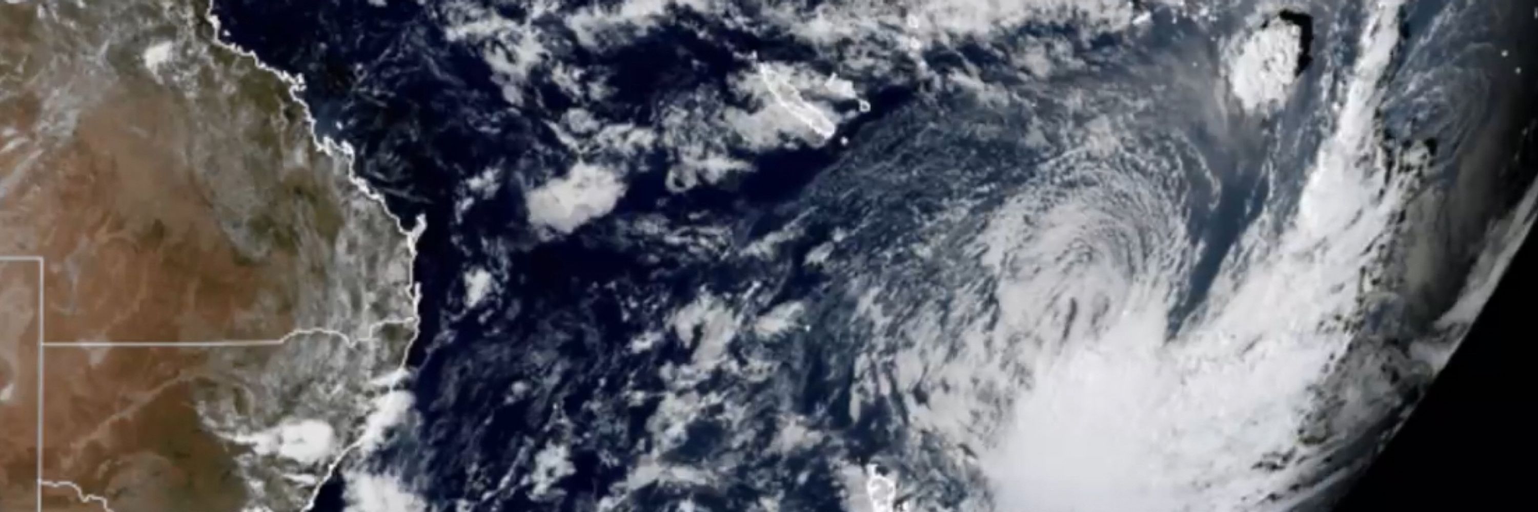
Former TC #Luana is over the #Kimberley region of #WesternAustralia. Another weak low pressure system is over the Cape York Peninsula, while monitoring tropical development near #Vanuatu next week.

January 25, 2026 at 8:07 AM
Former TC #Luana is over the #Kimberley region of #WesternAustralia. Another weak low pressure system is over the Cape York Peninsula, while monitoring tropical development near #Vanuatu next week.
Tropical Cyclone Luana just before it crosses the coast near Cape Leveque North of Broome
#TropicalCyclone #CycloneLuana #16U #17S #WAWx
#TropicalCyclone #CycloneLuana #16U #17S #WAWx
January 24, 2026 at 3:38 AM
Tropical Cyclone Luana just before it crosses the coast near Cape Leveque North of Broome
#TropicalCyclone #CycloneLuana #16U #17S #WAWx
#TropicalCyclone #CycloneLuana #16U #17S #WAWx
Reposted by James Holbeach🌀

James #Webb Space Telescope #JWST
Imaging dust knots in a planetary nebula
TARG: #NGC7293 #Helix Nebula
2024-10-24
PI: Garcia Marin, Macarena
NIRCAM 444-470 444 356 212 187 115
yuval-harpaz.github.io/astro/jwst_l...
NASA/ESA/CSA/STScI/j. Roger
Imaging dust knots in a planetary nebula
TARG: #NGC7293 #Helix Nebula
2024-10-24
PI: Garcia Marin, Macarena
NIRCAM 444-470 444 356 212 187 115
yuval-harpaz.github.io/astro/jwst_l...
NASA/ESA/CSA/STScI/j. Roger

January 20, 2026 at 7:26 PM
James #Webb Space Telescope #JWST
Imaging dust knots in a planetary nebula
TARG: #NGC7293 #Helix Nebula
2024-10-24
PI: Garcia Marin, Macarena
NIRCAM 444-470 444 356 212 187 115
yuval-harpaz.github.io/astro/jwst_l...
NASA/ESA/CSA/STScI/j. Roger
Imaging dust knots in a planetary nebula
TARG: #NGC7293 #Helix Nebula
2024-10-24
PI: Garcia Marin, Macarena
NIRCAM 444-470 444 356 212 187 115
yuval-harpaz.github.io/astro/jwst_l...
NASA/ESA/CSA/STScI/j. Roger
INVEST 91S may develop into a cyclone before crossing the coast North of Cape Leveque. SSTs are about normal for this time of year but definitely enough to support development if the low slows down. #91S #WAWx #TropicalCyclone


January 22, 2026 at 12:33 AM
INVEST 91S may develop into a cyclone before crossing the coast North of Cape Leveque. SSTs are about normal for this time of year but definitely enough to support development if the low slows down. #91S #WAWx #TropicalCyclone
This mess over Bonaparte gulf could consolidate into a tropical cyclone in the next week.

January 17, 2026 at 7:25 AM
This mess over Bonaparte gulf could consolidate into a tropical cyclone in the next week.
Using ai models to find errors in base data sets … especially when the models have been trained in the same data sets is impressive!!

January 13, 2026 at 4:28 AM
Using ai models to find errors in base data sets … especially when the models have been trained in the same data sets is impressive!!

Reposted by James Holbeach🌀

This is what it would look like to fly over the Martian North Pole aboard @esa.int's Mars Express orbiter.
This sequence of 117 images was captured by the VMC camera on June 14th, 2019 over the course of 3 hours and is played a 1200x speed. #planetsci
Credit: ESA/Simeon Schmauß
flic.kr/p/2rQAPdw
This sequence of 117 images was captured by the VMC camera on June 14th, 2019 over the course of 3 hours and is played a 1200x speed. #planetsci
Credit: ESA/Simeon Schmauß
flic.kr/p/2rQAPdw
January 6, 2026 at 7:00 PM
This is what it would look like to fly over the Martian North Pole aboard @esa.int's Mars Express orbiter.
This sequence of 117 images was captured by the VMC camera on June 14th, 2019 over the course of 3 hours and is played a 1200x speed. #planetsci
Credit: ESA/Simeon Schmauß
flic.kr/p/2rQAPdw
This sequence of 117 images was captured by the VMC camera on June 14th, 2019 over the course of 3 hours and is played a 1200x speed. #planetsci
Credit: ESA/Simeon Schmauß
flic.kr/p/2rQAPdw
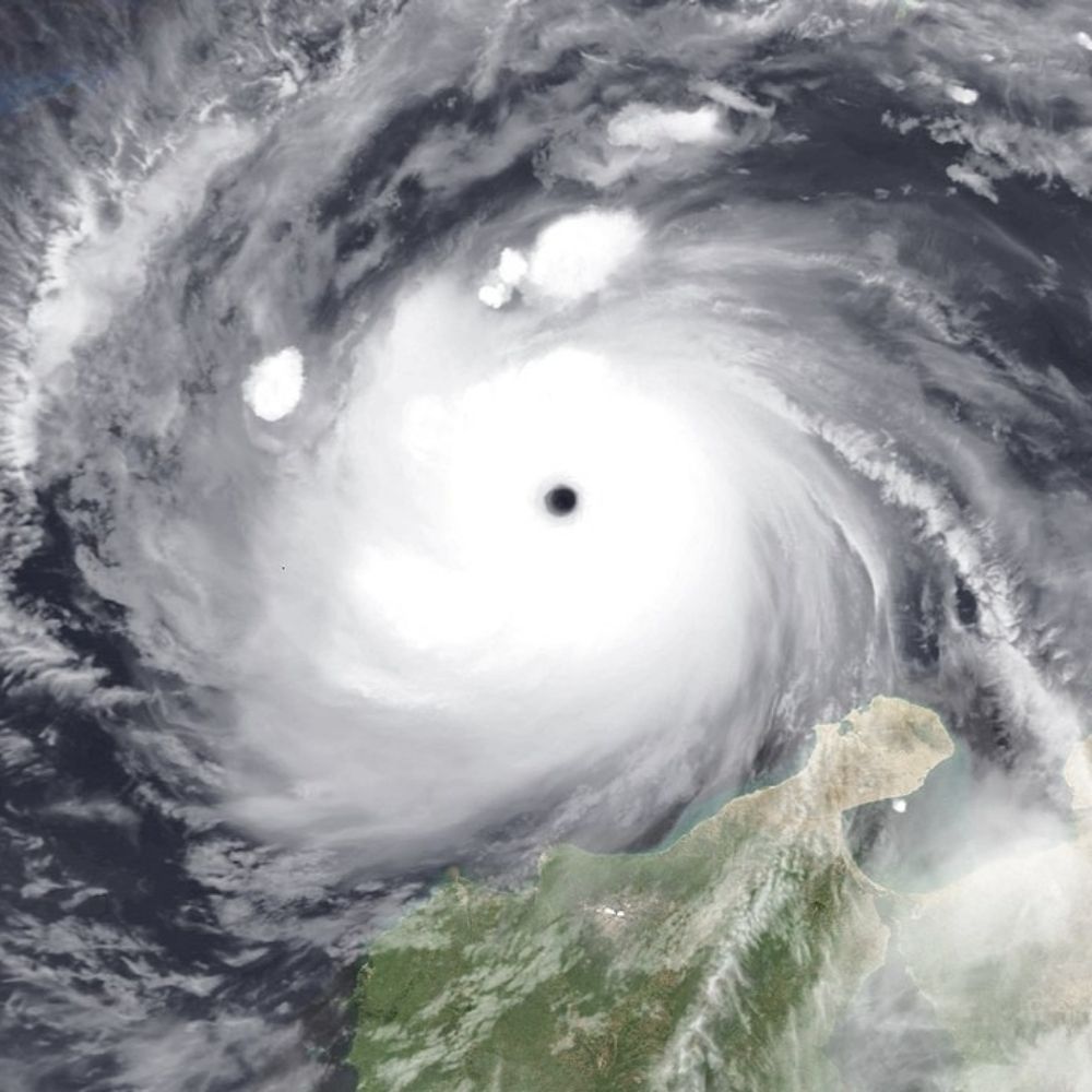
On 6th Jan Severe Tropical Cyclone Jenna peaked at category 3 (Aus scale) after skirting the Cocos Islands.
It made an impressive sight as it span away over the Indian ocean!
#WX #Cyclone #WAWx #CycloneJenna
It made an impressive sight as it span away over the Indian ocean!
#WX #Cyclone #WAWx #CycloneJenna
January 8, 2026 at 12:21 AM
On 6th Jan Severe Tropical Cyclone Jenna peaked at category 3 (Aus scale) after skirting the Cocos Islands.
It made an impressive sight as it span away over the Indian ocean!
#WX #Cyclone #WAWx #CycloneJenna
It made an impressive sight as it span away over the Indian ocean!
#WX #Cyclone #WAWx #CycloneJenna
Reposted by James Holbeach🌀

The North Atlantic tonight going into the final day of 2025. #avgeography @flightradar24.com

December 31, 2025 at 4:36 AM
The North Atlantic tonight going into the final day of 2025. #avgeography @flightradar24.com
Reposted by James Holbeach🌀
According to BOM Tropical Cyclone Hayley has now peaked as a category 4 on the Aus scale with 10 minute sustained wind speeds of 165 km/h (100 mph). JTWC 1 min est. is the same. Shear has seemingly begun to increase and should induce weakening leading up to landfall tonight local time.
December 29, 2025 at 8:55 PM
According to BOM Tropical Cyclone Hayley has now peaked as a category 4 on the Aus scale with 10 minute sustained wind speeds of 165 km/h (100 mph). JTWC 1 min est. is the same. Shear has seemingly begun to increase and should induce weakening leading up to landfall tonight local time.
Reposted by James Holbeach🌀
Recently named Cyclone #Hayley has unexpectedly intensified into a category 4. A cat 3 landfall is expected in the northern Kimberley.
The last season to see 3 severe TC's before the New Year was way back in 1998-99.
The last season to see 3 cat 4 TC's before the New Year was... never!
The last season to see 3 severe TC's before the New Year was way back in 1998-99.
The last season to see 3 cat 4 TC's before the New Year was... never!


December 29, 2025 at 10:40 PM
Recently named Cyclone #Hayley has unexpectedly intensified into a category 4. A cat 3 landfall is expected in the northern Kimberley.
The last season to see 3 severe TC's before the New Year was way back in 1998-99.
The last season to see 3 cat 4 TC's before the New Year was... never!
The last season to see 3 severe TC's before the New Year was way back in 1998-99.
The last season to see 3 cat 4 TC's before the New Year was... never!
GFS has a fairly intense cyclone forming just before New Years near Broome, WA.
It is important to note that no other model currently shows this however BOM have it as 08U with moderate chance for cyclone formation. Worth watching this one as a spinoff from the monsoon. Note another in GoC too.
It is important to note that no other model currently shows this however BOM have it as 08U with moderate chance for cyclone formation. Worth watching this one as a spinoff from the monsoon. Note another in GoC too.
December 22, 2025 at 10:48 PM
GFS has a fairly intense cyclone forming just before New Years near Broome, WA.
It is important to note that no other model currently shows this however BOM have it as 08U with moderate chance for cyclone formation. Worth watching this one as a spinoff from the monsoon. Note another in GoC too.
It is important to note that no other model currently shows this however BOM have it as 08U with moderate chance for cyclone formation. Worth watching this one as a spinoff from the monsoon. Note another in GoC too.
A number of fire scars are visible in the Northern Perth Hills area.
December 22, 2025 at 3:34 AM
A number of fire scars are visible in the Northern Perth Hills area.
Lightning caused a small bushfire in the Avin Valley National Park near Perth last week. This video is a comparison between 1 Dec and 21 Dec 2025 showing the fire scar. Top left is Avon River, Bottom right is Morangup subdivision.
Size is ~38Ha and uncomfortably close to my house!
#Bushfire #Perth
Size is ~38Ha and uncomfortably close to my house!
#Bushfire #Perth
December 21, 2025 at 11:33 PM
Reposted by James Holbeach🌀
#OTDwx in 2006 Cyclone Bondo underwent a very impressive period of rapid intensification northeast of Madagascar. According to JTWC winds increased from 65 to 135 knots in 18 hours. During this time a pinhole eye (as small as ~8 nm) rapidly cleared and warmed to >15°C.
December 19, 2025 at 10:27 PM
#OTDwx in 2006 Cyclone Bondo underwent a very impressive period of rapid intensification northeast of Madagascar. According to JTWC winds increased from 65 to 135 knots in 18 hours. During this time a pinhole eye (as small as ~8 nm) rapidly cleared and warmed to >15°C.
Reposted by James Holbeach🌀
Way out west of the Cocos Islands, Cyclone #Bakung moved into the Australian AoR on the weekend as a tiny, yet potent cyclone- intensifying to a category 3. The 2nd of the season now.
A sign of yet another season with a high percentage of severe TC's coming up?
A sign of yet another season with a high percentage of severe TC's coming up?

December 16, 2025 at 5:11 AM
Way out west of the Cocos Islands, Cyclone #Bakung moved into the Australian AoR on the weekend as a tiny, yet potent cyclone- intensifying to a category 3. The 2nd of the season now.
A sign of yet another season with a high percentage of severe TC's coming up?
A sign of yet another season with a high percentage of severe TC's coming up?
Movie you’ve watched more than six times with a gif. Hard mode: no Stars (Wars nor Trek), LOTR, or Marvel, Disney Animated or Pixar.
December 8, 2025 at 12:20 AM
Movie you’ve watched more than six times with a gif. Hard mode: no Stars (Wars nor Trek), LOTR, or Marvel, Disney Animated or Pixar.
Reposted by James Holbeach🌀

Pffffft, that's nothing. Talk to me when it's at least a magnitude 1.36720235285300.

#Earthquake Update: A magnitude 1.36720235285299 earthquake took place 4 km N of View Park-Windsor Hills, CA at 7:41:20 PM. #micro
For details from the USGS:
For details from the USGS:
M 1.4 - 4 km N of View Park-Windsor Hills, CA | 41127255
2025-11-26 03:11:20 (UTC) | -118.344°N 34.030°W | 3.4 km depth
earthquake.usgs.gov
November 26, 2025 at 3:50 AM
Pffffft, that's nothing. Talk to me when it's at least a magnitude 1.36720235285300.
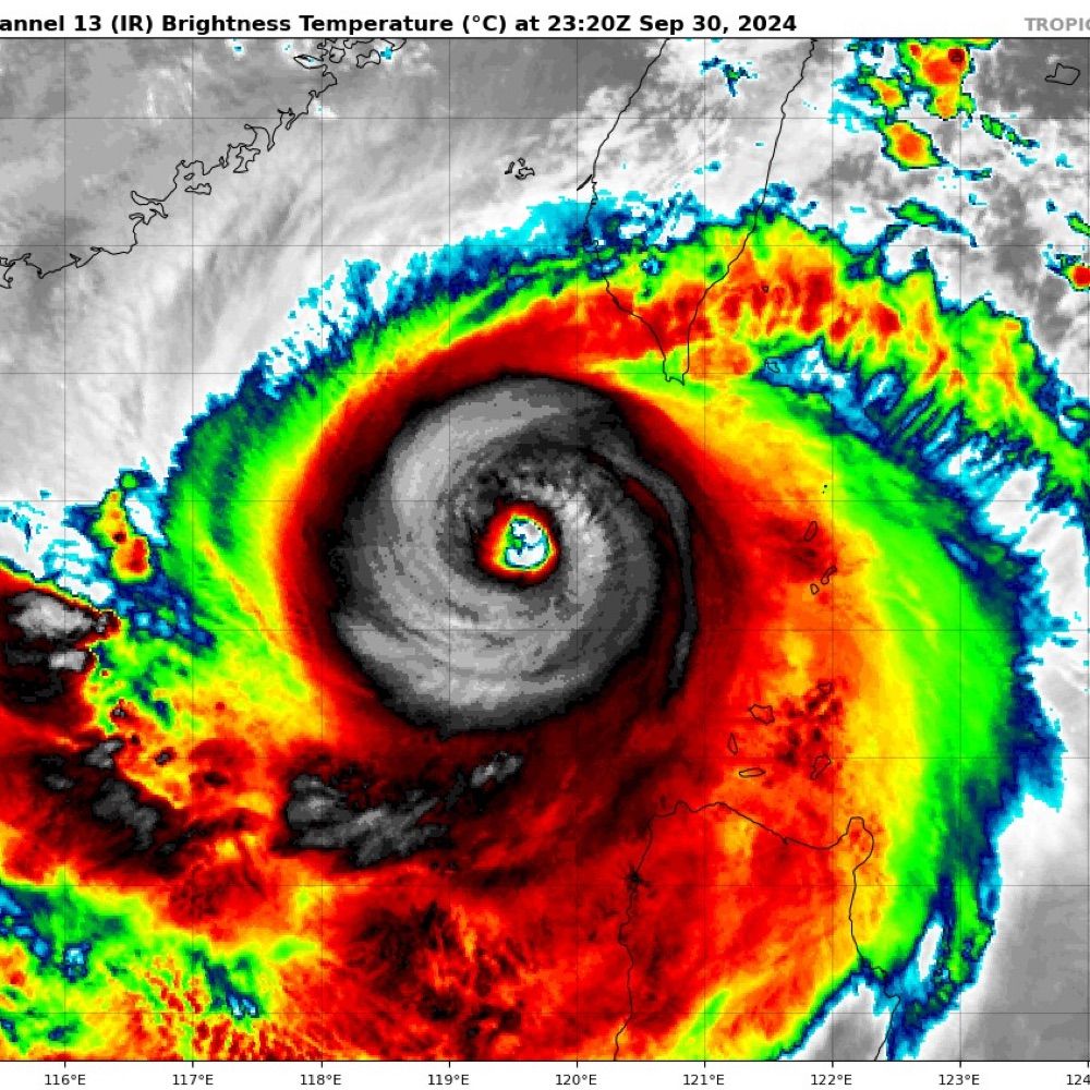
Lots of lightning around the eye of Severe Tropical Cyclone #Fina as it approaches the North Kimberly WA coast.
It is unusual to see this much lightning in such a strong system. Typically it indicates intensification in weaker systems. #CycloneFina #TCFina
It is unusual to see this much lightning in such a strong system. Typically it indicates intensification in weaker systems. #CycloneFina #TCFina
November 24, 2025 at 2:40 AM
Lots of lightning around the eye of Severe Tropical Cyclone #Fina as it approaches the North Kimberly WA coast.
It is unusual to see this much lightning in such a strong system. Typically it indicates intensification in weaker systems. #CycloneFina #TCFina
It is unusual to see this much lightning in such a strong system. Typically it indicates intensification in weaker systems. #CycloneFina #TCFina
A large burst of lightning to the NW of Tropical Cyclone Fina's circulation center also supports intensification. #TCFina #CycloneFina

November 21, 2025 at 12:50 AM
A large burst of lightning to the NW of Tropical Cyclone Fina's circulation center also supports intensification. #TCFina #CycloneFina
A significant convective flare from near the LLCC of #TCFina indicates intensification. I would not be surprised if it is back to Cat 2 (Aus scale) strength in the next bulletin.
Moisture good✅, SSTs warm✅, Shear low✅, Poleward outflow hampered❌ #CycloneFina #Fina #NT #AusWX
Moisture good✅, SSTs warm✅, Shear low✅, Poleward outflow hampered❌ #CycloneFina #Fina #NT #AusWX
November 21, 2025 at 12:31 AM
A significant convective flare from near the LLCC of #TCFina indicates intensification. I would not be surprised if it is back to Cat 2 (Aus scale) strength in the next bulletin.
Moisture good✅, SSTs warm✅, Shear low✅, Poleward outflow hampered❌ #CycloneFina #Fina #NT #AusWX
Moisture good✅, SSTs warm✅, Shear low✅, Poleward outflow hampered❌ #CycloneFina #Fina #NT #AusWX
Tropical #CycloneFina this morning, North east of the Tiwi Islands @50 kt sustained.
November 20, 2025 at 2:03 AM
Tropical #CycloneFina this morning, North east of the Tiwi Islands @50 kt sustained.
Tropical #CycloneFina over the last few hours showing a partially exposed LLCC in a dry slot between two blobs (technical term) of convective wet air.
November 19, 2025 at 2:21 AM
Tropical #CycloneFina over the last few hours showing a partially exposed LLCC in a dry slot between two blobs (technical term) of convective wet air.
Good morning Tropical Cyclone #Fina! #05S #02U. #CycloneFina A poorly organised cat 1 (Aus) system at the moment, with some banding, partially exposed LLCC, patchy moisture and poor convective structure.
Intensification predictions vary considerably, worth watching.
Intensification predictions vary considerably, worth watching.


November 19, 2025 at 1:49 AM
Good morning Tropical Cyclone #Fina! #05S #02U. #CycloneFina A poorly organised cat 1 (Aus) system at the moment, with some banding, partially exposed LLCC, patchy moisture and poor convective structure.
Intensification predictions vary considerably, worth watching.
Intensification predictions vary considerably, worth watching.