


Cameron H 🇦🇺
@hitchy04.bsky.social
Former North, now South QLD’er into Australian weather extremes/records, climate data visualisation, cyclones, and storm chasing.
Cold weather and soccer enjoyer
🟠⚫️ 🟢🟡
Cold weather and soccer enjoyer
🟠⚫️ 🟢🟡
Pinned
Cameron H 🇦🇺
@hitchy04.bsky.social
· Apr 6
Historic records:
So far in 2025, an incredible 2452.8mm has been recorded at #Townsville Airport
This already surpasses 2399.8mm in 2000 as the **WETTEST YEAR ON RECORD**
Yesterday was also the *27th* consecutive rain day (0.2mm+). This ties 23/12/1990-18/01/1991 as the longest streak on record!
So far in 2025, an incredible 2452.8mm has been recorded at #Townsville Airport
This already surpasses 2399.8mm in 2000 as the **WETTEST YEAR ON RECORD**
Yesterday was also the *27th* consecutive rain day (0.2mm+). This ties 23/12/1990-18/01/1991 as the longest streak on record!
Historic heatwave 🌡️
Marree in South Australia has recorded a historic 49.8c today.
This is the 4th hottest temperature ever recorded in the state, and 3rd hottest in January. Just 0.9c below the all-time state/national record!
Ties as 10th hottest all-time nationally.
Marree in South Australia has recorded a historic 49.8c today.
This is the 4th hottest temperature ever recorded in the state, and 3rd hottest in January. Just 0.9c below the all-time state/national record!
Ties as 10th hottest all-time nationally.

January 29, 2026 at 6:43 AM
Historic heatwave 🌡️
Marree in South Australia has recorded a historic 49.8c today.
This is the 4th hottest temperature ever recorded in the state, and 3rd hottest in January. Just 0.9c below the all-time state/national record!
Ties as 10th hottest all-time nationally.
Marree in South Australia has recorded a historic 49.8c today.
This is the 4th hottest temperature ever recorded in the state, and 3rd hottest in January. Just 0.9c below the all-time state/national record!
Ties as 10th hottest all-time nationally.
🌡️Scorching Australia Day today:
Ceduna recorded *49.5c* today! That ties as the 4th highest Jan temp/5th highest temp for any month on record in the state!
Just 1.2c below the national all-time record.
0.6c above site 2019 all-time record with 85yrs of data!
Ceduna recorded *49.5c* today! That ties as the 4th highest Jan temp/5th highest temp for any month on record in the state!
Just 1.2c below the national all-time record.
0.6c above site 2019 all-time record with 85yrs of data!


January 26, 2026 at 7:48 AM
🌡️Scorching Australia Day today:
Ceduna recorded *49.5c* today! That ties as the 4th highest Jan temp/5th highest temp for any month on record in the state!
Just 1.2c below the national all-time record.
0.6c above site 2019 all-time record with 85yrs of data!
Ceduna recorded *49.5c* today! That ties as the 4th highest Jan temp/5th highest temp for any month on record in the state!
Just 1.2c below the national all-time record.
0.6c above site 2019 all-time record with 85yrs of data!
It’s not the prettiest TC to exist, but Cyclone #Luana is starting to make its cat 1/2 landfall in the NW Kimberley region in a very similar location as TC Hayley last month
Max gust so far is 89kmh/48kt at Koolan Island.
8th cyclone this season already! Typical peak season is still weeks away…
Max gust so far is 89kmh/48kt at Koolan Island.
8th cyclone this season already! Typical peak season is still weeks away…


January 24, 2026 at 4:25 AM
It’s not the prettiest TC to exist, but Cyclone #Luana is starting to make its cat 1/2 landfall in the NW Kimberley region in a very similar location as TC Hayley last month
Max gust so far is 89kmh/48kt at Koolan Island.
8th cyclone this season already! Typical peak season is still weeks away…
Max gust so far is 89kmh/48kt at Koolan Island.
8th cyclone this season already! Typical peak season is still weeks away…
🌡️Shark Bay AP is the westernmost weather station on mainland Australia. Today it recorded an incredible *49.2c*!
Smashes the Jan record for site by 1.9c! 2nd hottest day for any month (0.6c below historic Feb 2024 record).
Hottest day nationally since 49.2c at Gascoyne Junction on Feb 3rd 2025.
Smashes the Jan record for site by 1.9c! 2nd hottest day for any month (0.6c below historic Feb 2024 record).
Hottest day nationally since 49.2c at Gascoyne Junction on Feb 3rd 2025.


January 20, 2026 at 10:20 AM
🌡️Shark Bay AP is the westernmost weather station on mainland Australia. Today it recorded an incredible *49.2c*!
Smashes the Jan record for site by 1.9c! 2nd hottest day for any month (0.6c below historic Feb 2024 record).
Hottest day nationally since 49.2c at Gascoyne Junction on Feb 3rd 2025.
Smashes the Jan record for site by 1.9c! 2nd hottest day for any month (0.6c below historic Feb 2024 record).
Hottest day nationally since 49.2c at Gascoyne Junction on Feb 3rd 2025.
Category 2 Cyclone #Koji has just been named off NQ.
A slight move east means Townsville will see the weaker western half, while the towns & islands south of Ayr will see the strongest winds.
Willis Island recorded a 133kmh/72kt gust at 12:41pm! 80kmh at Hamilton Island. Massive windfield.
A slight move east means Townsville will see the weaker western half, while the towns & islands south of Ayr will see the strongest winds.
Willis Island recorded a 133kmh/72kt gust at 12:41pm! 80kmh at Hamilton Island. Massive windfield.

January 10, 2026 at 7:11 AM
Category 2 Cyclone #Koji has just been named off NQ.
A slight move east means Townsville will see the weaker western half, while the towns & islands south of Ayr will see the strongest winds.
Willis Island recorded a 133kmh/72kt gust at 12:41pm! 80kmh at Hamilton Island. Massive windfield.
A slight move east means Townsville will see the weaker western half, while the towns & islands south of Ayr will see the strongest winds.
Willis Island recorded a 133kmh/72kt gust at 12:41pm! 80kmh at Hamilton Island. Massive windfield.
TL #12U is now expected to develop into Cyclone #Koji shortly before a category 1 landfall just north of #Townsville very early on Sunday.
Due to the large windfield, a TC warning has been issued from Port Douglas-Tully. A TC watch issued from Cardwell-Airlie Beach.
Due to the large windfield, a TC warning has been issued from Port Douglas-Tully. A TC watch issued from Cardwell-Airlie Beach.

January 9, 2026 at 1:25 AM
TL #12U is now expected to develop into Cyclone #Koji shortly before a category 1 landfall just north of #Townsville very early on Sunday.
Due to the large windfield, a TC warning has been issued from Port Douglas-Tully. A TC watch issued from Cardwell-Airlie Beach.
Due to the large windfield, a TC warning has been issued from Port Douglas-Tully. A TC watch issued from Cardwell-Airlie Beach.
The first track map for TL #12U has just been released.
While not expected to become a named cyclone due to technical structural reasons, it will have TC strength winds when it makes landfall (currently forecast near #Townsville on Sunday arvo).
45% chance to be named #Koji tomorrow or Saturday.
While not expected to become a named cyclone due to technical structural reasons, it will have TC strength winds when it makes landfall (currently forecast near #Townsville on Sunday arvo).
45% chance to be named #Koji tomorrow or Saturday.

January 8, 2026 at 7:37 AM
The first track map for TL #12U has just been released.
While not expected to become a named cyclone due to technical structural reasons, it will have TC strength winds when it makes landfall (currently forecast near #Townsville on Sunday arvo).
45% chance to be named #Koji tomorrow or Saturday.
While not expected to become a named cyclone due to technical structural reasons, it will have TC strength winds when it makes landfall (currently forecast near #Townsville on Sunday arvo).
45% chance to be named #Koji tomorrow or Saturday.
🌡️🥵HOTTEST MINIMUM TEMP ON RECORD IN WESTERN AUSTRALIA:
Paraburdoo dropped to 'only' 35.8c last night- 0.3c above the 2003 all-time WA record. Also 6th hottest Tmin nationally, just 0.8c below!
Today Onslow at 49c, just 0.2c below site record. Above 44c in SA, QLD, Vic & NSW
Paraburdoo dropped to 'only' 35.8c last night- 0.3c above the 2003 all-time WA record. Also 6th hottest Tmin nationally, just 0.8c below!
Today Onslow at 49c, just 0.2c below site record. Above 44c in SA, QLD, Vic & NSW

January 7, 2026 at 7:37 AM
🌡️🥵HOTTEST MINIMUM TEMP ON RECORD IN WESTERN AUSTRALIA:
Paraburdoo dropped to 'only' 35.8c last night- 0.3c above the 2003 all-time WA record. Also 6th hottest Tmin nationally, just 0.8c below!
Today Onslow at 49c, just 0.2c below site record. Above 44c in SA, QLD, Vic & NSW
Paraburdoo dropped to 'only' 35.8c last night- 0.3c above the 2003 all-time WA record. Also 6th hottest Tmin nationally, just 0.8c below!
Today Onslow at 49c, just 0.2c below site record. Above 44c in SA, QLD, Vic & NSW
Another Aussie capital down- Perth is now off the bucket list.
Brisbane ✅
Sydney ✅
Melbourne ✅
Darwin ✅
Canberra ✅
Perth ✅
Hobart ❌
Adelaide ❌
Brisbane ✅
Sydney ✅
Melbourne ✅
Darwin ✅
Canberra ✅
Perth ✅
Hobart ❌
Adelaide ❌


January 2, 2026 at 12:00 PM
Another Aussie capital down- Perth is now off the bucket list.
Brisbane ✅
Sydney ✅
Melbourne ✅
Darwin ✅
Canberra ✅
Perth ✅
Hobart ❌
Adelaide ❌
Brisbane ✅
Sydney ✅
Melbourne ✅
Darwin ✅
Canberra ✅
Perth ✅
Hobart ❌
Adelaide ❌
HISTORIC WETTEST YEAR ON RECORD AT TOWNSVILLE
An incredible 2950.8mm fell in 2025 at the airport
That destroys the 2000 airport record by more than *half a METRE*. Data since 1941.
Even the old Pilot Station still can't compare, with it's 1894 record 468mm below 2025! Data since 1888
An incredible 2950.8mm fell in 2025 at the airport
That destroys the 2000 airport record by more than *half a METRE*. Data since 1941.
Even the old Pilot Station still can't compare, with it's 1894 record 468mm below 2025! Data since 1888
December 31, 2025 at 2:37 AM
HISTORIC WETTEST YEAR ON RECORD AT TOWNSVILLE
An incredible 2950.8mm fell in 2025 at the airport
That destroys the 2000 airport record by more than *half a METRE*. Data since 1941.
Even the old Pilot Station still can't compare, with it's 1894 record 468mm below 2025! Data since 1888
An incredible 2950.8mm fell in 2025 at the airport
That destroys the 2000 airport record by more than *half a METRE*. Data since 1941.
Even the old Pilot Station still can't compare, with it's 1894 record 468mm below 2025! Data since 1888
Recently named Cyclone #Hayley has unexpectedly intensified into a category 4. A cat 3 landfall is expected in the northern Kimberley.
The last season to see 3 severe TC's before the New Year was way back in 1998-99.
The last season to see 3 cat 4 TC's before the New Year was... never!
The last season to see 3 severe TC's before the New Year was way back in 1998-99.
The last season to see 3 cat 4 TC's before the New Year was... never!


December 29, 2025 at 10:40 PM
Recently named Cyclone #Hayley has unexpectedly intensified into a category 4. A cat 3 landfall is expected in the northern Kimberley.
The last season to see 3 severe TC's before the New Year was way back in 1998-99.
The last season to see 3 cat 4 TC's before the New Year was... never!
The last season to see 3 severe TC's before the New Year was way back in 1998-99.
The last season to see 3 cat 4 TC's before the New Year was... never!
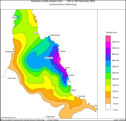
On this day in 2023, the rainfall peak was occurring during the passage of Ex TC Jasper in FNQ.
At Black Mt TM, the rain gauge recorded a mind-blowing daily total of *975mm*
That's the highest 24hr total ever reliably recorded in Australian history.
3 sites exceeded 2000mm in 5 days!
At Black Mt TM, the rain gauge recorded a mind-blowing daily total of *975mm*
That's the highest 24hr total ever reliably recorded in Australian history.
3 sites exceeded 2000mm in 5 days!
December 17, 2025 at 5:15 AM
On this day in 2023, the rainfall peak was occurring during the passage of Ex TC Jasper in FNQ.
At Black Mt TM, the rain gauge recorded a mind-blowing daily total of *975mm*
That's the highest 24hr total ever reliably recorded in Australian history.
3 sites exceeded 2000mm in 5 days!
At Black Mt TM, the rain gauge recorded a mind-blowing daily total of *975mm*
That's the highest 24hr total ever reliably recorded in Australian history.
3 sites exceeded 2000mm in 5 days!
Way out west of the Cocos Islands, Cyclone #Bakung moved into the Australian AoR on the weekend as a tiny, yet potent cyclone- intensifying to a category 3. The 2nd of the season now.
A sign of yet another season with a high percentage of severe TC's coming up?
A sign of yet another season with a high percentage of severe TC's coming up?

December 16, 2025 at 5:11 AM
Way out west of the Cocos Islands, Cyclone #Bakung moved into the Australian AoR on the weekend as a tiny, yet potent cyclone- intensifying to a category 3. The 2nd of the season now.
A sign of yet another season with a high percentage of severe TC's coming up?
A sign of yet another season with a high percentage of severe TC's coming up?
Tragic day for all fellow Aussies today. 12 people shot dead (including a shooter) in a terror attack on one of our most iconic beaches- the deadliest mass shooting nationally since Port Arthur in 1996😢

NSW Police are responding to reports of an active shooter at Bondi Beach in Sydney's eastern suburbs.

Breaking: NSW Police responding to reports of shooter at Bondi Beach
NSW Police are responding to reports of an active shooter at Bondi Beach in Sydney's eastern suburbs.
www.abc.net.au
December 14, 2025 at 11:50 AM
Tragic day for all fellow Aussies today. 12 people shot dead (including a shooter) in a terror attack on one of our most iconic beaches- the deadliest mass shooting nationally since Port Arthur in 1996😢
🥶Wintry day across SE (esp alpine) Australia yesterday.
#Thredbo Top Station recorded a max of just -0.8c. **Tied 2nd coldest Summer/December TMAX on record in AUSTRALIA/NSW!**
National record is -1c.
Mt #Hotham recorded -0.7c **tied 2nd coldest Summer TMAX in VICTORIA** 0.1c above state record
#Thredbo Top Station recorded a max of just -0.8c. **Tied 2nd coldest Summer/December TMAX on record in AUSTRALIA/NSW!**
National record is -1c.
Mt #Hotham recorded -0.7c **tied 2nd coldest Summer TMAX in VICTORIA** 0.1c above state record

December 2, 2025 at 12:43 PM
A wintry start to Summer across SE Australia today with snow falling in the Alps.
As of 7:30pm AEDT, Thredbo has a provisional max temperature of just -0.8c.
*IF* that holds until 9am tomorrow, that ties as 2nd coldest Summer day on record in Australia.
Will update tomorrow.
As of 7:30pm AEDT, Thredbo has a provisional max temperature of just -0.8c.
*IF* that holds until 9am tomorrow, that ties as 2nd coldest Summer day on record in Australia.
Will update tomorrow.

December 1, 2025 at 8:47 AM
A wintry start to Summer across SE Australia today with snow falling in the Alps.
As of 7:30pm AEDT, Thredbo has a provisional max temperature of just -0.8c.
*IF* that holds until 9am tomorrow, that ties as 2nd coldest Summer day on record in Australia.
Will update tomorrow.
As of 7:30pm AEDT, Thredbo has a provisional max temperature of just -0.8c.
*IF* that holds until 9am tomorrow, that ties as 2nd coldest Summer day on record in Australia.
Will update tomorrow.
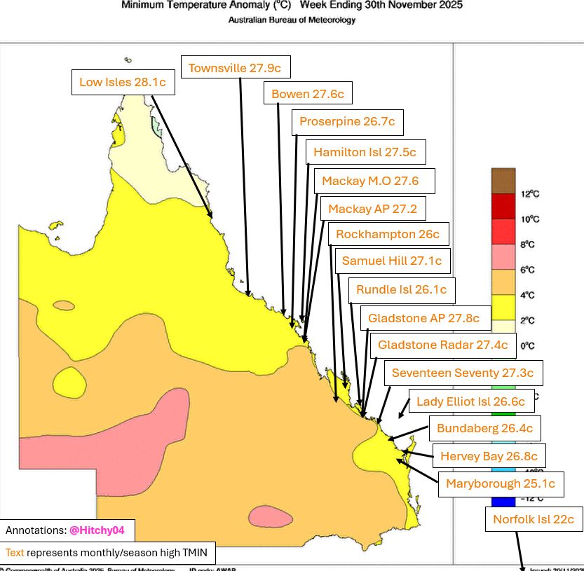
Record warm Spring nights along coastal QLD this week. 2nd straight month of records for some sites!
Low Isles 28.1c (27.8c 2018) POR 58yrs
Townsville 27.9c (27.9c 1988) POR 85yrs!
Bowen 27.6c (27.2c 2022) Combined POR 38yrs
Low Isles 28.1c (27.8c 2018) POR 58yrs
Townsville 27.9c (27.9c 1988) POR 85yrs!
Bowen 27.6c (27.2c 2022) Combined POR 38yrs
November 30, 2025 at 5:14 AM
Record warm Spring nights along coastal QLD this week. 2nd straight month of records for some sites!
Low Isles 28.1c (27.8c 2018) POR 58yrs
Townsville 27.9c (27.9c 1988) POR 85yrs!
Bowen 27.6c (27.2c 2022) Combined POR 38yrs
Low Isles 28.1c (27.8c 2018) POR 58yrs
Townsville 27.9c (27.9c 1988) POR 85yrs!
Bowen 27.6c (27.2c 2022) Combined POR 38yrs
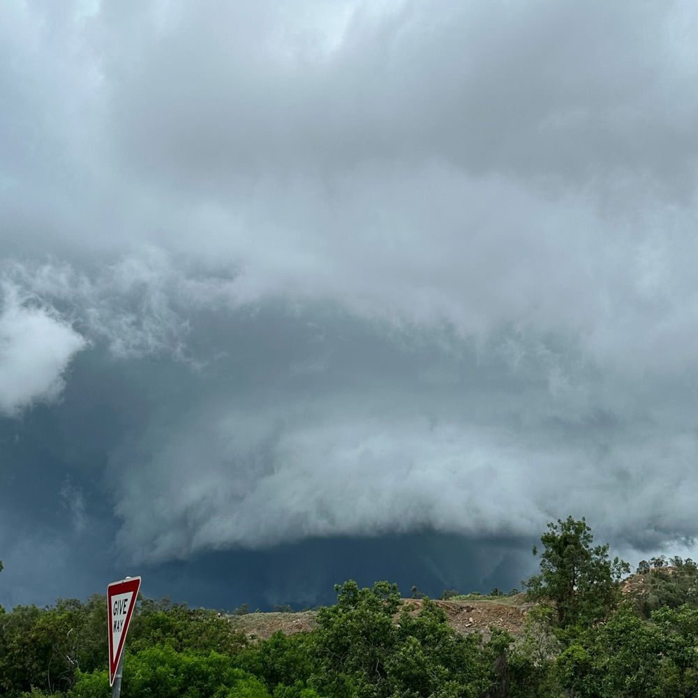
Captured these severe #thunderstorms as they pushed offshore in the #Brisbane area this evening.
Looked spectacular with the sun setting.
Looked spectacular with the sun setting.


November 27, 2025 at 8:44 AM
Captured these severe #thunderstorms as they pushed offshore in the #Brisbane area this evening.
Looked spectacular with the sun setting.
Looked spectacular with the sun setting.
The remnants of TC #Fina are still kicking in far north WA with another rain record falling yesterday.
Wyndham recorded 147.2mm- easily it's wettest Spring/November day since combined records began in 1898 (93.2mm 1986). A record start to the wet season.
Wettest Spring/Nov day in WA since 2001.
Wyndham recorded 147.2mm- easily it's wettest Spring/November day since combined records began in 1898 (93.2mm 1986). A record start to the wet season.
Wettest Spring/Nov day in WA since 2001.

November 26, 2025 at 5:00 AM
The remnants of TC #Fina are still kicking in far north WA with another rain record falling yesterday.
Wyndham recorded 147.2mm- easily it's wettest Spring/November day since combined records began in 1898 (93.2mm 1986). A record start to the wet season.
Wettest Spring/Nov day in WA since 2001.
Wyndham recorded 147.2mm- easily it's wettest Spring/November day since combined records began in 1898 (93.2mm 1986). A record start to the wet season.
Wettest Spring/Nov day in WA since 2001.
After a cool start to Nov, W QLD returns to record heat.
Bedourie recorded a *34.2c* MINIMUM temp on Sunday night (prelim but very likely as 9am temp was 39.1c).
That's the *3rd hottest Spring/Nov night ever recorded in Australia*. Just 0.8c below state/national 1965 record!
More records likely.
Bedourie recorded a *34.2c* MINIMUM temp on Sunday night (prelim but very likely as 9am temp was 39.1c).
That's the *3rd hottest Spring/Nov night ever recorded in Australia*. Just 0.8c below state/national 1965 record!
More records likely.

November 25, 2025 at 5:13 AM
After a cool start to Nov, W QLD returns to record heat.
Bedourie recorded a *34.2c* MINIMUM temp on Sunday night (prelim but very likely as 9am temp was 39.1c).
That's the *3rd hottest Spring/Nov night ever recorded in Australia*. Just 0.8c below state/national 1965 record!
More records likely.
Bedourie recorded a *34.2c* MINIMUM temp on Sunday night (prelim but very likely as 9am temp was 39.1c).
That's the *3rd hottest Spring/Nov night ever recorded in Australia*. Just 0.8c below state/national 1965 record!
More records likely.
Cyclone #Fina made her final landfall at about 9:30pm AWST last night on a very remote part of the northern Kimberley coast as a severe category 3. W/ a ~7km wide eye
That’s the first November severe landfall since TC Quenton made landfall as a cat 4 in 1983.
What a cyclone.
That’s the first November severe landfall since TC Quenton made landfall as a cat 4 in 1983.
What a cyclone.

November 25, 2025 at 12:05 AM
Cyclone #Fina made her final landfall at about 9:30pm AWST last night on a very remote part of the northern Kimberley coast as a severe category 3. W/ a ~7km wide eye
That’s the first November severe landfall since TC Quenton made landfall as a cat 4 in 1983.
What a cyclone.
That’s the first November severe landfall since TC Quenton made landfall as a cat 4 in 1983.
What a cyclone.
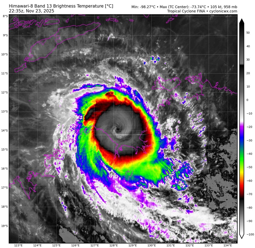
Tiny Cyclone #Fina has been taking advantage of the extremely warm ocean in the JB Gulf, strengthening to a category 4 yesterday. Fair bit of lightning in eyewall still.
Due to a delayed weakening, Fina now forecast to make her final landfall as a cat 3 in remote N WA today.
Due to a delayed weakening, Fina now forecast to make her final landfall as a cat 3 in remote N WA today.
November 24, 2025 at 12:12 AM
Tiny Cyclone #Fina has been taking advantage of the extremely warm ocean in the JB Gulf, strengthening to a category 4 yesterday. Fair bit of lightning in eyewall still.
Due to a delayed weakening, Fina now forecast to make her final landfall as a cat 3 in remote N WA today.
Due to a delayed weakening, Fina now forecast to make her final landfall as a cat 3 in remote N WA today.
Cyclone #Fina intensified into a cat 3 cyclone this morning and is now starting to clear out an eye signifying further intensification.
#Darwin to see worst conditions tonight/early AM
BOM now forecasts a cat 4 months peak over the JBG tomorrow partly thanks to very high OHC.
#Darwin to see worst conditions tonight/early AM
BOM now forecasts a cat 4 months peak over the JBG tomorrow partly thanks to very high OHC.


November 22, 2025 at 5:46 AM
#CycloneFina made a historic landfall at about 10:30pm overnight on the Cobourg Peninsula as a category 2.
Easily the earliest #cyclone landfall on record in the NT (TC Alessia Nov 27th 2013).
Also the 3rd earliest landfall nationally (hours later than Ines 1973, 01U 19th 1910).
Easily the earliest #cyclone landfall on record in the NT (TC Alessia Nov 27th 2013).
Also the 3rd earliest landfall nationally (hours later than Ines 1973, 01U 19th 1910).

November 22, 2025 at 12:47 AM
#CycloneFina made a historic landfall at about 10:30pm overnight on the Cobourg Peninsula as a category 2.
Easily the earliest #cyclone landfall on record in the NT (TC Alessia Nov 27th 2013).
Also the 3rd earliest landfall nationally (hours later than Ines 1973, 01U 19th 1910).
Easily the earliest #cyclone landfall on record in the NT (TC Alessia Nov 27th 2013).
Also the 3rd earliest landfall nationally (hours later than Ines 1973, 01U 19th 1910).