


OpenHistoricalMap
@openhistoricalmap.org
Explore the world throughout time, mapped in minute detail by people like you & dedicated to the public domain. OHM is a charter project of @osmus.bsky.social and cousin of @openstreetmap.bsky.social. #oldmaps #dh #hgis
https://www.openhistoricalmap.org
https://www.openhistoricalmap.org
Reposted by OpenHistoricalMap

By request, here's a thread of books that I think make excellent gifts this holiday season (obviously they're cartographically inclined, you know me)
1. Best anthology
"All Over the Map" by Betsy Mason and Greg Miller
A gorgeous, full color history of maps mind-bending maps from around the world.
1. Best anthology
"All Over the Map" by Betsy Mason and Greg Miller
A gorgeous, full color history of maps mind-bending maps from around the world.
November 21, 2025 at 7:35 PM
By request, here's a thread of books that I think make excellent gifts this holiday season (obviously they're cartographically inclined, you know me)
1. Best anthology
"All Over the Map" by Betsy Mason and Greg Miller
A gorgeous, full color history of maps mind-bending maps from around the world.
1. Best anthology
"All Over the Map" by Betsy Mason and Greg Miller
A gorgeous, full color history of maps mind-bending maps from around the world.
Our database will be in read-only mode for a planned upgrade next Monday, November 24, at 19:00 UTC. We expect the upgrade to take about 3 hours. During that time, you won’t be able to save any changes, but you’ll be able to view and query the map as usual. Thank you for your patience.
November 18, 2025 at 5:32 PM
Our database will be in read-only mode for a planned upgrade next Monday, November 24, at 19:00 UTC. We expect the upgrade to take about 3 hours. During that time, you won’t be able to save any changes, but you’ll be able to view and query the map as usual. Thank you for your patience.
It was a privilege to introduce the software #internationalization and #localization community to #OpenHistoricalMap (and #OpenStreetMap and @maplibre.org) at #UTW2025. Join us in mapping yesterday already!
#i18n #l10n
#i18n #l10n

November 13, 2025 at 7:10 PM
It was a privilege to introduce the software #internationalization and #localization community to #OpenHistoricalMap (and #OpenStreetMap and @maplibre.org) at #UTW2025. Join us in mapping yesterday already!
#i18n #l10n
#i18n #l10n
In October, the #OpenHistoricalMap community added 87,784 dated elements, 28,666 buildings, and 15,202½ railroad miles. The average age of a dated element fell by 15 months, and the average year shifted one year later. All this with the help of 40 new contributors – welcome!
osm.wiki/OHM/Statistics
osm.wiki/OHM/Statistics
OpenHistoricalMap/Statistics - OpenStreetMap Wiki
wiki.openstreetmap.org
November 6, 2025 at 8:32 AM
In October, the #OpenHistoricalMap community added 87,784 dated elements, 28,666 buildings, and 15,202½ railroad miles. The average age of a dated element fell by 15 months, and the average year shifted one year later. All this with the help of 40 new contributors – welcome!
osm.wiki/OHM/Statistics
osm.wiki/OHM/Statistics
Anyone mapping the history of the German Autobahn? We have a particularly fleißig mapper who has set up a project for the daunting task of mapping the historical evolution of die Bundesautobahn & he's off to a great start...
#HGIS #OpenStreetMap #OpenHistoricalMap #DH #Germany #Highways #History
#HGIS #OpenStreetMap #OpenHistoricalMap #DH #Germany #Highways #History

November 5, 2025 at 12:43 AM
Anyone mapping the history of the German Autobahn? We have a particularly fleißig mapper who has set up a project for the daunting task of mapping the historical evolution of die Bundesautobahn & he's off to a great start...
#HGIS #OpenStreetMap #OpenHistoricalMap #DH #Germany #Highways #History
#HGIS #OpenStreetMap #OpenHistoricalMap #DH #Germany #Highways #History
Reposted by OpenHistoricalMap
The breakage from last week is now fixed. You can once again use the map in any language and preview tagged images and Wikipedia articles in the sidebar. Please let us know if you continue to see any issues.
October 29, 2025 at 10:18 PM
The breakage from last week is now fixed. You can once again use the map in any language and preview tagged images and Wikipedia articles in the sidebar. Please let us know if you continue to see any issues.
Reposted by OpenHistoricalMap

Secret Maps opens today! 🤫 🗺️
From medieval manuscripts to Cold War espionage, our new exhibition explores how maps have hidden as much as they revealed for over 600 years.
Book now: bit.ly/BLSecretMaps
From medieval manuscripts to Cold War espionage, our new exhibition explores how maps have hidden as much as they revealed for over 600 years.
Book now: bit.ly/BLSecretMaps
October 24, 2025 at 12:26 PM
Secret Maps opens today! 🤫 🗺️
From medieval manuscripts to Cold War espionage, our new exhibition explores how maps have hidden as much as they revealed for over 600 years.
Book now: bit.ly/BLSecretMaps
From medieval manuscripts to Cold War espionage, our new exhibition explores how maps have hidden as much as they revealed for over 600 years.
Book now: bit.ly/BLSecretMaps
Any Australian OHM mappers out there? This seems like a great complement to our efforts that might benefit from an improved 1970s Melbourne basemap!
#Australia #DH #PastMapping
#OpenStreetMap #Melbourne
#Australia #DH #PastMapping
#OpenStreetMap #Melbourne

New prototype from my #slvresidency! This one lets you explore photos from the Committee for Urban Action collection by selecting one of the highlighted roads on a map of Victoria. It's very much work-in-progress and will probably change a lot, but you can […]
[Original post on hcommons.social]
[Original post on hcommons.social]

October 24, 2025 at 6:32 PM
Any Australian OHM mappers out there? This seems like a great complement to our efforts that might benefit from an improved 1970s Melbourne basemap!
#Australia #DH #PastMapping
#OpenStreetMap #Melbourne
#Australia #DH #PastMapping
#OpenStreetMap #Melbourne
We’re aware that the map on our homepage is currently nonfunctional in some languages. If you are seeing this issue, please switch the interface to English for now. Thank you for your patience.
forum.openhistoricalmap.org/t/broken-hom...
forum.openhistoricalmap.org/t/broken-hom...

Broken homepage map (in some languages) and inspector images
The map on the homepage is currently nonfunctional in some languages. If you are seeing this issue, please switch the interface to English for now. To change your interface language, click the 文A butt...
forum.openhistoricalmap.org
October 22, 2025 at 10:29 PM
We’re aware that the map on our homepage is currently nonfunctional in some languages. If you are seeing this issue, please switch the interface to English for now. Thank you for your patience.
forum.openhistoricalmap.org/t/broken-hom...
forum.openhistoricalmap.org/t/broken-hom...
Reposted by OpenHistoricalMap

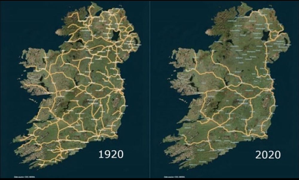
The Irish Railway System between 1920 and 2020, name a bigger downgrade in history.
Why it happened: brilliantmaps.com/irish-rai...
Why it happened: brilliantmaps.com/irish-rai...
October 21, 2025 at 4:01 PM
The Irish Railway System between 1920 and 2020, name a bigger downgrade in history.
Why it happened: brilliantmaps.com/irish-rai...
Why it happened: brilliantmaps.com/irish-rai...


Had a great time presenting about how OHM & Wikimedia can be used together at #WikiconferenceNA. The focus of my talk was on how OHM data's tagging can include to add source information not just for geometry, but also for attributes, and that all of this is easily downloadable for reuse. #DH /1
October 19, 2025 at 7:04 PM
Had a great time presenting about how OHM & Wikimedia can be used together at #WikiconferenceNA. The focus of my talk was on how OHM data's tagging can include to add source information not just for geometry, but also for attributes, and that all of this is easily downloadable for reuse. #DH /1
Reposted by OpenHistoricalMap

The second day of Wikiconference North America 2025 kicks off today with an enlightening and highly entertaining talk with longtime Wikipedia champion @craignewmark.bsky.social and @depthsofwikipedia.bsky.social. Follow along as we post updates today! #wikiconferenceNA

October 18, 2025 at 2:55 PM
The second day of Wikiconference North America 2025 kicks off today with an enlightening and highly entertaining talk with longtime Wikipedia champion @craignewmark.bsky.social and @depthsofwikipedia.bsky.social. Follow along as we post updates today! #wikiconferenceNA
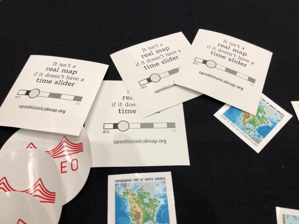
If you’re in #Loouhvull for #NACIS #NACIS2025, look out for these OpenHistoricalMap stickers. Snag one and keep it real! (For the record, we have a scale bar too.)
October 16, 2025 at 11:45 PM
If you’re in #Loouhvull for #NACIS #NACIS2025, look out for these OpenHistoricalMap stickers. Snag one and keep it real! (For the record, we have a scale bar too.)
We've set up some new networking rules on our sites, so if you're seeing any 503 or other errors, please DM and we'll fix things up! #NotYouBots
October 10, 2025 at 6:38 PM
We've set up some new networking rules on our sites, so if you're seeing any 503 or other errors, please DM and we'll fix things up! #NotYouBots
Reposted by OpenHistoricalMap

Nicely done!
Here's the tutorial 👉 youtu.be/JfDW8P51MmA
Here's the tutorial 👉 youtu.be/JfDW8P51MmA
October 10, 2025 at 6:36 PM
Nicely done!
Here's the tutorial 👉 youtu.be/JfDW8P51MmA
Here's the tutorial 👉 youtu.be/JfDW8P51MmA
In September, the #OpenHistoricalMap community added 78,430 dated elements, 10,580 buildings, and 20,439¼ railroad miles. The average age of a dated element fell by 21 months, and the average year shifted 17 months later. All this with the help of 30 new mappers – welcome!
osm.wiki/OHM/Statistics
osm.wiki/OHM/Statistics
OpenHistoricalMap/Statistics - OpenStreetMap Wiki
wiki.openstreetmap.org
October 8, 2025 at 7:34 AM
In September, the #OpenHistoricalMap community added 78,430 dated elements, 10,580 buildings, and 20,439¼ railroad miles. The average age of a dated element fell by 21 months, and the average year shifted 17 months later. All this with the help of 30 new mappers – welcome!
osm.wiki/OHM/Statistics
osm.wiki/OHM/Statistics

October 3, 2025 at 6:30 AM
Reposted by OpenHistoricalMap

Help @maprva.org develop an historical street view of Richmond, VA by georeferencing old photographs! The catalog is actively growing and currently includes 1900 photos from the Library of Virginia and the @thevalentinerva.bsky.social
georeference.maprva.org
georeference.maprva.org
September 12, 2025 at 8:40 PM
Help @maprva.org develop an historical street view of Richmond, VA by georeferencing old photographs! The catalog is actively growing and currently includes 1900 photos from the Library of Virginia and the @thevalentinerva.bsky.social
georeference.maprva.org
georeference.maprva.org
Reposted by OpenHistoricalMap

Question for the medieval crowd: does anyone know of a good published map of Europe in 1066? (yes, I have googled)
September 10, 2025 at 5:22 PM
Question for the medieval crowd: does anyone know of a good published map of Europe in 1066? (yes, I have googled)
¡Buenas días de #Medellín y #SOTMLatAm #SotMLatam2025! ¡Agradecemos a encontrar todos los mapeadores aquí! @rub21.bsky.social y Minh Nguyễn van a presentar sobre la tema de #OpenHistoricalMap el sábado.


September 5, 2025 at 4:26 PM
¡Buenas días de #Medellín y #SOTMLatAm #SotMLatam2025! ¡Agradecemos a encontrar todos los mapeadores aquí! @rub21.bsky.social y Minh Nguyễn van a presentar sobre la tema de #OpenHistoricalMap el sábado.
In August, the #OpenHistoricalMap community added 71,946 dated elements, 12,256 buildings, and 10,475¾ railroad miles. The average age of a dated element fell by 13 months, and the average year shifted 4 months later. All this with the help of 30 new contributors – welcome!
osm.wiki/OHM/Statistics
osm.wiki/OHM/Statistics
OpenHistoricalMap/Statistics - OpenStreetMap Wiki
wiki.openstreetmap.org
September 1, 2025 at 11:37 PM
In August, the #OpenHistoricalMap community added 71,946 dated elements, 12,256 buildings, and 10,475¾ railroad miles. The average age of a dated element fell by 13 months, and the average year shifted 4 months later. All this with the help of 30 new contributors – welcome!
osm.wiki/OHM/Statistics
osm.wiki/OHM/Statistics
Clues about history are never far and neither is @vespucci.io. With its new support for editing OHM, you can jot down what you learn from a #cornerstone #plaque #SidewalkStamp right on the spot, before the dates get jumbled around in your head.
vespucci.io/tutorials/sw...
vespucci.io/tutorials/sw...
Switching and adding OpenStreetMap data APIs - Vespucci
Main site for Vespucci the Android OpenStreetMap Editor
vespucci.io
August 27, 2025 at 2:30 AM
Clues about history are never far and neither is @vespucci.io. With its new support for editing OHM, you can jot down what you learn from a #cornerstone #plaque #SidewalkStamp right on the spot, before the dates get jumbled around in your head.
vespucci.io/tutorials/sw...
vespucci.io/tutorials/sw...
@itspangler.bsky.social gives an overview of the map resources at @bplmaps.bsky.social and tools for turning them into geodata:
openstreetmap.us/events/state...
#StateOfTheMapUS #SOTMUS
openstreetmap.us/events/state...
#StateOfTheMapUS #SOTMUS

Urban atlases, library collections, and historical geodata
openstreetmap.us
August 19, 2025 at 7:10 PM
@itspangler.bsky.social gives an overview of the map resources at @bplmaps.bsky.social and tools for turning them into geodata:
openstreetmap.us/events/state...
#StateOfTheMapUS #SOTMUS
openstreetmap.us/events/state...
#StateOfTheMapUS #SOTMUS
Reposted by OpenHistoricalMap

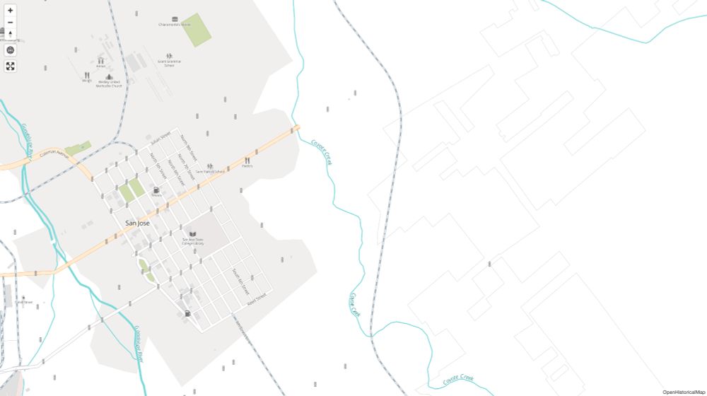
#SanJose is looking a little busier in #OpenHistoricalMap. Comprehensive historical coverage of #TrafficLights (courtesy of the city) makes it easier to tell where the major streets ran.
www.openhistoricalmap.org#map=15/37.33...
wiki.openstreetmap.org/wiki/OpenHis...
1960 and today:
www.openhistoricalmap.org#map=15/37.33...
wiki.openstreetmap.org/wiki/OpenHis...
1960 and today:

August 14, 2025 at 2:14 AM
#SanJose is looking a little busier in #OpenHistoricalMap. Comprehensive historical coverage of #TrafficLights (courtesy of the city) makes it easier to tell where the major streets ran.
www.openhistoricalmap.org#map=15/37.33...
wiki.openstreetmap.org/wiki/OpenHis...
1960 and today:
www.openhistoricalmap.org#map=15/37.33...
wiki.openstreetmap.org/wiki/OpenHis...
1960 and today: