


OpenHistoricalMap
@openhistoricalmap.org
Explore the world throughout time, mapped in minute detail by people like you & dedicated to the public domain. OHM is a charter project of @osmus.bsky.social and cousin of @openstreetmap.bsky.social. #oldmaps #dh #hgis
https://www.openhistoricalmap.org
https://www.openhistoricalmap.org
It was a privilege to introduce the software #internationalization and #localization community to #OpenHistoricalMap (and #OpenStreetMap and @maplibre.org) at #UTW2025. Join us in mapping yesterday already!
#i18n #l10n
#i18n #l10n

November 13, 2025 at 7:10 PM
It was a privilege to introduce the software #internationalization and #localization community to #OpenHistoricalMap (and #OpenStreetMap and @maplibre.org) at #UTW2025. Join us in mapping yesterday already!
#i18n #l10n
#i18n #l10n
Anyone mapping the history of the German Autobahn? We have a particularly fleißig mapper who has set up a project for the daunting task of mapping the historical evolution of die Bundesautobahn & he's off to a great start...
#HGIS #OpenStreetMap #OpenHistoricalMap #DH #Germany #Highways #History
#HGIS #OpenStreetMap #OpenHistoricalMap #DH #Germany #Highways #History

November 5, 2025 at 12:43 AM
Anyone mapping the history of the German Autobahn? We have a particularly fleißig mapper who has set up a project for the daunting task of mapping the historical evolution of die Bundesautobahn & he's off to a great start...
#HGIS #OpenStreetMap #OpenHistoricalMap #DH #Germany #Highways #History
#HGIS #OpenStreetMap #OpenHistoricalMap #DH #Germany #Highways #History
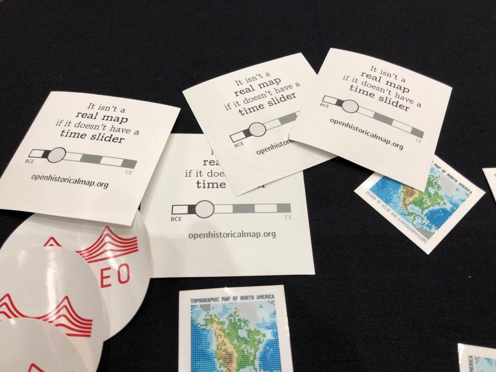
If you’re in #Loouhvull for #NACIS #NACIS2025, look out for these OpenHistoricalMap stickers. Snag one and keep it real! (For the record, we have a scale bar too.)
October 16, 2025 at 11:45 PM
If you’re in #Loouhvull for #NACIS #NACIS2025, look out for these OpenHistoricalMap stickers. Snag one and keep it real! (For the record, we have a scale bar too.)
Love this! Added some metadata to link to an image & to more info. A little hyper-local curation of the hyper-local mapping. Please fix any mistakes made by this former RVA resident (long before the Gun Hole!)
www.openhistoricalmap.org/node/2140307...
#RVA #LocalHistory #Micromapping
www.openhistoricalmap.org/node/2140307...
#RVA #LocalHistory #Micromapping

October 16, 2025 at 11:24 PM
Love this! Added some metadata to link to an image & to more info. A little hyper-local curation of the hyper-local mapping. Please fix any mistakes made by this former RVA resident (long before the Gun Hole!)
www.openhistoricalmap.org/node/2140307...
#RVA #LocalHistory #Micromapping
www.openhistoricalmap.org/node/2140307...
#RVA #LocalHistory #Micromapping

October 3, 2025 at 6:30 AM
We'd love to help Jacob & others build these extensions, if there's interest. 🙏
And, of course, if anyone would like to keep improving the RVA section of OHM, we'd love to support that, too... just sayin'! 😎
www.openhistoricalmap.org#map=16/37.53...
And, of course, if anyone would like to keep improving the RVA section of OHM, we'd love to support that, too... just sayin'! 😎
www.openhistoricalmap.org#map=16/37.53...

September 22, 2025 at 7:11 PM
We'd love to help Jacob & others build these extensions, if there's interest. 🙏
And, of course, if anyone would like to keep improving the RVA section of OHM, we'd love to support that, too... just sayin'! 😎
www.openhistoricalmap.org#map=16/37.53...
And, of course, if anyone would like to keep improving the RVA section of OHM, we'd love to support that, too... just sayin'! 😎
www.openhistoricalmap.org#map=16/37.53...
People are probably knocking down your door to add new features, but obviously... we'd love to see an OHM base map that matches the year of the picture, storage of your POIs in OHM, tagging of places in OHM... you name it!
www.openhistoricalmap.org/way/19947902...
www.openhistoricalmap.org/way/19947902...

September 22, 2025 at 7:11 PM
People are probably knocking down your door to add new features, but obviously... we'd love to see an OHM base map that matches the year of the picture, storage of your POIs in OHM, tagging of places in OHM... you name it!
www.openhistoricalmap.org/way/19947902...
www.openhistoricalmap.org/way/19947902...
¡Buenas días de #Medellín y #SOTMLatAm #SotMLatam2025! ¡Agradecemos a encontrar todos los mapeadores aquí! @rub21.bsky.social y Minh Nguyễn van a presentar sobre la tema de #OpenHistoricalMap el sábado.


September 5, 2025 at 4:26 PM
¡Buenas días de #Medellín y #SOTMLatAm #SotMLatam2025! ¡Agradecemos a encontrar todos los mapeadores aquí! @rub21.bsky.social y Minh Nguyễn van a presentar sobre la tema de #OpenHistoricalMap el sábado.
June saw more newly added buildings than in any month since recordkeeping began (for us, anyway). Most of it comes from an import of the Basic Register of Addresses and Buildings that’s getting underway in the Netherlands.
forum.openhistoricalmap.org/t/importing-...
#BAG #Nederlands
forum.openhistoricalmap.org/t/importing-...
#BAG #Nederlands


July 2, 2025 at 5:59 AM
June saw more newly added buildings than in any month since recordkeeping began (for us, anyway). Most of it comes from an import of the Basic Register of Addresses and Buildings that’s getting underway in the Netherlands.
forum.openhistoricalmap.org/t/importing-...
#BAG #Nederlands
forum.openhistoricalmap.org/t/importing-...
#BAG #Nederlands
Can you spot the differences? #HighlightsMagazine

June 20, 2025 at 10:16 PM
Can you spot the differences? #HighlightsMagazine
@itspangler.bsky.social from @bplmaps.bsky.social holding court in the Leventhal Room at the Boston Harbor Hotel for rapt #StateOfTheMapUS attendees. Thank you, Ian & Leventhal! 🙏🏼🗺️⏳ #OSM #OldMaps


June 20, 2025 at 10:13 PM
@itspangler.bsky.social from @bplmaps.bsky.social holding court in the Leventhal Room at the Boston Harbor Hotel for rapt #StateOfTheMapUS attendees. Thank you, Ian & Leventhal! 🙏🏼🗺️⏳ #OSM #OldMaps
On the walk to #StateOfTheMapUS at #BostonUniverdity and seeing geo / map / history references everywhere... #OSMUS #OpenStreetMap #Boston


June 20, 2025 at 1:50 PM
On the walk to #StateOfTheMapUS at #BostonUniverdity and seeing geo / map / history references everywhere... #OSMUS #OpenStreetMap #Boston
When worlds collide: "Navigating Map Libraries: The Leventhal Map Center and OHM," which will highlight how the #crowdsourced OSM world can work with #GLAM resources, using the resources at @bplmaps.bsky.social as an examplar!
#DH #HGIS #Libraries #Archives
#DH #HGIS #Libraries #Archives

June 18, 2025 at 7:23 PM
When worlds collide: "Navigating Map Libraries: The Leventhal Map Center and OHM," which will highlight how the #crowdsourced OSM world can work with #GLAM resources, using the resources at @bplmaps.bsky.social as an examplar!
#DH #HGIS #Libraries #Archives
#DH #HGIS #Libraries #Archives
Map labels match your preferred language setting, like the rest of the site. Now you can understand the map even if you don’t speak a language that was common halfway around the world centuries ago. It’s also a lot easier for mappers to know where to improve our language coverage. #l10n #i18n 🧵 3/4


June 14, 2025 at 2:43 AM
Do you already contribute to @openstreetmap.bsky.social? You can start contributing to OpenHistoricalMap too in just a few clicks, without having to juggle yet another password for yet another mapping site. Once you have a taste of OSM #SingleSignOn via #OAuth2, you’ll never look back. 🧵 2/4

June 14, 2025 at 2:40 AM
Do you already contribute to @openstreetmap.bsky.social? You can start contributing to OpenHistoricalMap too in just a few clicks, without having to juggle yet another password for yet another mapping site. Once you have a taste of OSM #SingleSignOn via #OAuth2, you’ll never look back. 🧵 2/4
Great thread on in-depth mapping of local history by @sk53onosm.bsky.social over on OSM Town Mastodon:
mapstodon.space/@SK53@en.osm...
🙏 to OSMF for sponsoring OSM Town.
#CliftonEstate #Nottingham #EastMidlands #HGIS #DH #VectorMaps #OSM #HistoricalSocieties #OldMaps
mapstodon.space/@SK53@en.osm...
🙏 to OSMF for sponsoring OSM Town.
#CliftonEstate #Nottingham #EastMidlands #HGIS #DH #VectorMaps #OSM #HistoricalSocieties #OldMaps

April 11, 2025 at 8:17 PM
Great thread on in-depth mapping of local history by @sk53onosm.bsky.social over on OSM Town Mastodon:
mapstodon.space/@SK53@en.osm...
🙏 to OSMF for sponsoring OSM Town.
#CliftonEstate #Nottingham #EastMidlands #HGIS #DH #VectorMaps #OSM #HistoricalSocieties #OldMaps
mapstodon.space/@SK53@en.osm...
🙏 to OSMF for sponsoring OSM Town.
#CliftonEstate #Nottingham #EastMidlands #HGIS #DH #VectorMaps #OSM #HistoricalSocieties #OldMaps
Thanks for the shout-out! 🙏
The data goes back much further than 1825... that's just the default setting that can be adjusted in the UI.
The data goes back much further than 1825... that's just the default setting that can be adjusted in the UI.

March 25, 2025 at 9:47 PM
Thanks for the shout-out! 🙏
The data goes back much further than 1825... that's just the default setting that can be adjusted in the UI.
The data goes back much further than 1825... that's just the default setting that can be adjusted in the UI.