


Noor Hashmi (she/her)
@noorhashmi.bsky.social
ORCID: 0009-0002-6711-5649
MA Early Modern History student at The University of Sheffield, specialising in Caribbean slavery in the 17th & 18th centuries.
📸 Instagram: @historian_noor
#SkyStorian #SkyStorians #AcademicSky
MA Early Modern History student at The University of Sheffield, specialising in Caribbean slavery in the 17th & 18th centuries.
📸 Instagram: @historian_noor
#SkyStorian #SkyStorians #AcademicSky
Pinned

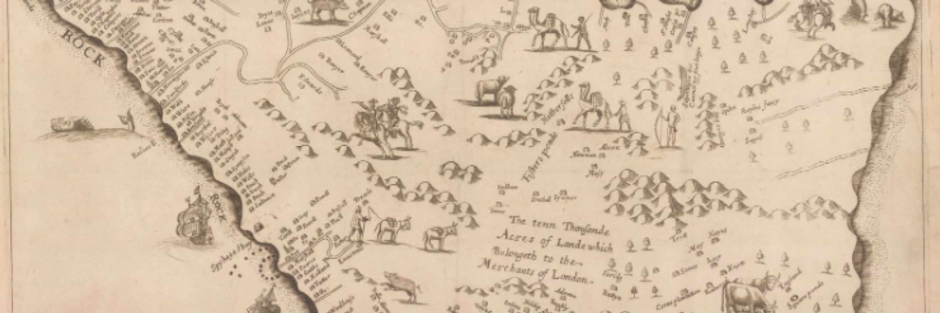
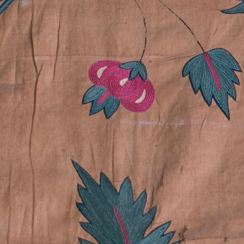
My first proper blog post for @globalmarhist.bsky.social 🙌🏻 This is the source I repeatedly return to when I teach others about Caribbean slavery.
There is so much that can be gleaned from this source alone. My post discusses some of the features!
There is so much that can be gleaned from this source alone. My post discusses some of the features!
Reposted by Noor Hashmi (she/her)

This year, History Workshop Journal will celebrate two milestones: its 50th anniversary and its 100th issue.
To mark the occasion, eleven historians share how they've used the journal in their own teaching.
To mark the occasion, eleven historians share how they've used the journal in their own teaching.

HWJ in the Classroom
From histories of the French Revolution, to policing in Early Modern England, to LGBTQ+ histories, these reflections highlight HWJ as a valuable resource across many different classrooms.
www.historyworkshop.org.uk
January 6, 2026 at 7:00 AM
This year, History Workshop Journal will celebrate two milestones: its 50th anniversary and its 100th issue.
To mark the occasion, eleven historians share how they've used the journal in their own teaching.
To mark the occasion, eleven historians share how they've used the journal in their own teaching.
Reposted by Noor Hashmi (she/her)

In 1887, British forces kidnapped & exiled the King of Opobo in today’s Nigeria. British Palm oil traders had persuaded the government that the tariffs he imposed restricted their profits. It was a milestone in the Scramble for Africa and indirect rule by Britain.
alanlester.co.uk/blog/antisla...
alanlester.co.uk/blog/antisla...

Antislavery and the Original ‘Scramble for Africa’, 1807-1879
Keynote Lecture for 140 Years Beyond the Berlin Conference, Africa Centre and SOAS Friday 12 December and Saturday 13 December 2025 Alan Lester Most British imperial historians have tended t…
alanlester.co.uk
January 4, 2026 at 8:34 AM
In 1887, British forces kidnapped & exiled the King of Opobo in today’s Nigeria. British Palm oil traders had persuaded the government that the tariffs he imposed restricted their profits. It was a milestone in the Scramble for Africa and indirect rule by Britain.
alanlester.co.uk/blog/antisla...
alanlester.co.uk/blog/antisla...
Reposted by Noor Hashmi (she/her)

You all, after YEARS of archival research and writing, my book is out in exactly ONE month and it’s my job to promote it. Please help me spread the word!! 😀📚#booksky

December 27, 2025 at 5:02 PM
You all, after YEARS of archival research and writing, my book is out in exactly ONE month and it’s my job to promote it. Please help me spread the word!! 😀📚#booksky
Just woke up from a 10/10 nap, would recommend😌
MERRY CHRISTMAS EVERYONE! 🎄💝 ft. one of my favourite Xmas songs from one of my favourite artists ever🥂
MERRY CHRISTMAS EVERYONE! 🎄💝 ft. one of my favourite Xmas songs from one of my favourite artists ever🥂

December 25, 2025 at 2:43 PM
Just woke up from a 10/10 nap, would recommend😌
MERRY CHRISTMAS EVERYONE! 🎄💝 ft. one of my favourite Xmas songs from one of my favourite artists ever🥂
MERRY CHRISTMAS EVERYONE! 🎄💝 ft. one of my favourite Xmas songs from one of my favourite artists ever🥂
Reposted by Noor Hashmi (she/her)
My forthcoming book—
For which I began research in 2006.
Is now posted on the website for Princeton University Press.
Cover will be added soon.
The King’s Slaves: The British Empire & the Origins of American Slavery
For which I began research in 2006.
Is now posted on the website for Princeton University Press.
Cover will be added soon.
The King’s Slaves: The British Empire & the Origins of American Slavery
The King's Slaves
A provocative account of how empire and absolutism institutionalized slavery in America
press.princeton.edu
December 18, 2025 at 11:14 PM
My forthcoming book—
For which I began research in 2006.
Is now posted on the website for Princeton University Press.
Cover will be added soon.
The King’s Slaves: The British Empire & the Origins of American Slavery
For which I began research in 2006.
Is now posted on the website for Princeton University Press.
Cover will be added soon.
The King’s Slaves: The British Empire & the Origins of American Slavery
Reposted by Noor Hashmi (she/her)


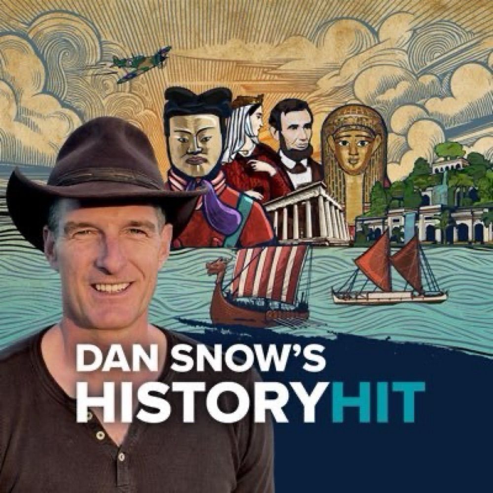
When America Tried BUT FAILED To Bring Segregation To Britain (Ep2)
YouTube video by Journey Through Time
youtu.be
December 15, 2025 at 1:09 PM
Reposted by Noor Hashmi (she/her)

What does Gen AI mean for the work of the historian and the value of historical experience, skills and craft?
'The Historian in the Age of AI' by @chriscampbell1.bsky.social.
New Comment article now available in 'Transactions of the Royal Historical Society' bit.ly/4atErTB #Skystorians 1/2
'The Historian in the Age of AI' by @chriscampbell1.bsky.social.
New Comment article now available in 'Transactions of the Royal Historical Society' bit.ly/4atErTB #Skystorians 1/2

December 11, 2025 at 2:08 PM
What does Gen AI mean for the work of the historian and the value of historical experience, skills and craft?
'The Historian in the Age of AI' by @chriscampbell1.bsky.social.
New Comment article now available in 'Transactions of the Royal Historical Society' bit.ly/4atErTB #Skystorians 1/2
'The Historian in the Age of AI' by @chriscampbell1.bsky.social.
New Comment article now available in 'Transactions of the Royal Historical Society' bit.ly/4atErTB #Skystorians 1/2
My first proper blog post for @globalmarhist.bsky.social 🙌🏻 This is the source I repeatedly return to when I teach others about Caribbean slavery.
There is so much that can be gleaned from this source alone. My post discusses some of the features!
There is so much that can be gleaned from this source alone. My post discusses some of the features!
December 1, 2025 at 11:59 AM
My first proper blog post for @globalmarhist.bsky.social 🙌🏻 This is the source I repeatedly return to when I teach others about Caribbean slavery.
There is so much that can be gleaned from this source alone. My post discusses some of the features!
There is so much that can be gleaned from this source alone. My post discusses some of the features!
Reposted by Noor Hashmi (she/her)

reminded of eric williams's observation about britain's relationship to its history with slavery. "British historians wrote almost as if Britain had introduced Negro slavery solely for the satisfaction of abolishing it."
holy shit: “Among the 2,000 UK adults surveyed, 85% were unaware that Britain forcibly transported more than 3 million Africans to the Caribbean, 89% did not know that Britain enslaved people in the Caribbean for more than 300 years” www.theguardian.com/world/2025/n...

Caribbean reparations leaders in ‘historic’ first UK visit to press for justice
CRC mission will seek to deepen public understanding of Britain’s colonial legacy and its lasting impact
www.theguardian.com
November 16, 2025 at 11:11 PM
reminded of eric williams's observation about britain's relationship to its history with slavery. "British historians wrote almost as if Britain had introduced Negro slavery solely for the satisfaction of abolishing it."
Reposted by Noor Hashmi (she/her)
And this is why CARICOM has to do the work of pressing for reparations and why they need other countries’ support: caricomreparations.org

Homepage - Caribbean Reparations Commission
Journal of Pan-African Studies: With speeches by Sir Hilary Beckles’s, the CARICOM 10-Point Reparations Plan, and [...]
caricomreparations.org
November 16, 2025 at 10:55 PM
And this is why CARICOM has to do the work of pressing for reparations and why they need other countries’ support: caricomreparations.org
Whenever I tell people I specialise in Caribbean slavery, there will always be someone who says “but it’s such an uncomfortable and heavy topic!”
Personally, the fact that thousands of UK adults are unaware of Britain’s role in the slave trade makes me feel uncomfortable.
How disappointing.
Personally, the fact that thousands of UK adults are unaware of Britain’s role in the slave trade makes me feel uncomfortable.
How disappointing.
holy shit: “Among the 2,000 UK adults surveyed, 85% were unaware that Britain forcibly transported more than 3 million Africans to the Caribbean, 89% did not know that Britain enslaved people in the Caribbean for more than 300 years” www.theguardian.com/world/2025/n...
Caribbean reparations leaders in ‘historic’ first UK visit to press for justice
CRC mission will seek to deepen public understanding of Britain’s colonial legacy and its lasting impact
www.theguardian.com
November 16, 2025 at 11:00 PM
Whenever I tell people I specialise in Caribbean slavery, there will always be someone who says “but it’s such an uncomfortable and heavy topic!”
Personally, the fact that thousands of UK adults are unaware of Britain’s role in the slave trade makes me feel uncomfortable.
How disappointing.
Personally, the fact that thousands of UK adults are unaware of Britain’s role in the slave trade makes me feel uncomfortable.
How disappointing.
Reposted by Noor Hashmi (she/her)
Hello all!
I have made an Instagram account for all things history/research related! I’ll still be on here, but do give me a follow on the other place if you wish. I’ll be posting on there every now and again! 😊
I have made an Instagram account for all things history/research related! I’ll still be on here, but do give me a follow on the other place if you wish. I’ll be posting on there every now and again! 😊

November 2, 2025 at 7:37 PM
Hello all!
I have made an Instagram account for all things history/research related! I’ll still be on here, but do give me a follow on the other place if you wish. I’ll be posting on there every now and again! 😊
I have made an Instagram account for all things history/research related! I’ll still be on here, but do give me a follow on the other place if you wish. I’ll be posting on there every now and again! 😊
Reposted by Noor Hashmi (she/her)
How do Lenny Henry’s arguments for reparations for trans-Atlantic slavery stand up to Lord Biggar’s arguments against them? Head-to-head review here:


November 12, 2025 at 8:13 AM
How do Lenny Henry’s arguments for reparations for trans-Atlantic slavery stand up to Lord Biggar’s arguments against them? Head-to-head review here:
Reposted by Noor Hashmi (she/her)
Guy Fawkes took the brilliantly original pseudonym “John Johnson” for his attempt to blow up Parliament today in 1605
We should make sure that anyone of that surname should not be allowed within a mile of the building.
We should make sure that anyone of that surname should not be allowed within a mile of the building.
November 5, 2025 at 8:43 PM
Guy Fawkes took the brilliantly original pseudonym “John Johnson” for his attempt to blow up Parliament today in 1605
We should make sure that anyone of that surname should not be allowed within a mile of the building.
We should make sure that anyone of that surname should not be allowed within a mile of the building.
Hello all!
I have made an Instagram account for all things history/research related! I’ll still be on here, but do give me a follow on the other place if you wish. I’ll be posting on there every now and again! 😊
I have made an Instagram account for all things history/research related! I’ll still be on here, but do give me a follow on the other place if you wish. I’ll be posting on there every now and again! 😊
November 2, 2025 at 7:37 PM
Hello all!
I have made an Instagram account for all things history/research related! I’ll still be on here, but do give me a follow on the other place if you wish. I’ll be posting on there every now and again! 😊
I have made an Instagram account for all things history/research related! I’ll still be on here, but do give me a follow on the other place if you wish. I’ll be posting on there every now and again! 😊
Reposted by Noor Hashmi (she/her)
Teaching the histories of slavery and keen to inform your students with insights from the most recent research?
Just a month to go before @uclpress.bsky.social publishes this open access (free to download) expert volume. uclpress.co.uk/book/teachin...
Just a month to go before @uclpress.bsky.social publishes this open access (free to download) expert volume. uclpress.co.uk/book/teachin...

Teaching Slavery
This groundbreaking book brings together the latest academic research on Britain’s involvement in transatlantic slavery, with innovative thinking on the teaching of such challenging histories in the c...
uclpress.co.uk
October 28, 2025 at 8:19 AM
Teaching the histories of slavery and keen to inform your students with insights from the most recent research?
Just a month to go before @uclpress.bsky.social publishes this open access (free to download) expert volume. uclpress.co.uk/book/teachin...
Just a month to go before @uclpress.bsky.social publishes this open access (free to download) expert volume. uclpress.co.uk/book/teachin...
Reposted by Noor Hashmi (she/her)

The slave trade was an international criminal enterprise. In 1811 an uprising on the slaving ship Amelia off the coast of West Africa revealed a complex network spanning four continents.
🔒 This feature from the October issue is available in the archive
www.historytoday.com/archive/feat...
🔒 This feature from the October issue is available in the archive
www.historytoday.com/archive/feat...

Slavery After Abolition: Revolt on the Amelia
www.historytoday.com
October 14, 2025 at 2:57 PM
The slave trade was an international criminal enterprise. In 1811 an uprising on the slaving ship Amelia off the coast of West Africa revealed a complex network spanning four continents.
🔒 This feature from the October issue is available in the archive
www.historytoday.com/archive/feat...
🔒 This feature from the October issue is available in the archive
www.historytoday.com/archive/feat...
Reposted by Noor Hashmi (she/her)

Going to present a chapter of my book manuscript on October 24, 12:30 PM EST. It is a detailed look on the European market for sugar and tobacco over 120 years that tries to break with methodological nationalism through multisited, multilanguage research on dozens of archives. On zoom as well.

October 11, 2025 at 7:04 PM
Going to present a chapter of my book manuscript on October 24, 12:30 PM EST. It is a detailed look on the European market for sugar and tobacco over 120 years that tries to break with methodological nationalism through multisited, multilanguage research on dozens of archives. On zoom as well.
Reposted by Noor Hashmi (she/her)
Exciting trans-Atlantic collaboration between the libraries at Universities of Rochester and Leeds:
🌎 Archives across the Atlantic: Unearthing Black History. A conversation with the University of Rochester ( 🗓️ Thursday 23 October at 🕓 4pm BST / 🕚 11am EDT)
leeds.libcal.com/calendar/ope...
🌎 Archives across the Atlantic: Unearthing Black History. A conversation with the University of Rochester ( 🗓️ Thursday 23 October at 🕓 4pm BST / 🕚 11am EDT)
leeds.libcal.com/calendar/ope...

Archives across the Atlantic: Unearthing Black History. A conversation with the University of Rochester.
Leeds has a rich, though still under-discussed, history of anti-slavery activism. For instance, the Leeds Anti-Slavery Association was established in 1853 at The Leeds Library on...
leeds.libcal.com
October 9, 2025 at 10:29 PM
Exciting trans-Atlantic collaboration between the libraries at Universities of Rochester and Leeds:
🌎 Archives across the Atlantic: Unearthing Black History. A conversation with the University of Rochester ( 🗓️ Thursday 23 October at 🕓 4pm BST / 🕚 11am EDT)
leeds.libcal.com/calendar/ope...
🌎 Archives across the Atlantic: Unearthing Black History. A conversation with the University of Rochester ( 🗓️ Thursday 23 October at 🕓 4pm BST / 🕚 11am EDT)
leeds.libcal.com/calendar/ope...
Reposted by Noor Hashmi (she/her)
'A nationwide survey commissioned by Henry VIII on the property and wealth of 16th century England and Wales is to be made publicly accessible for the first time.
The survey, known as the Valor Ecclesiasticus, set out to discover the financial state of the Church'.
The survey, known as the Valor Ecclesiasticus, set out to discover the financial state of the Church'.

National project launched to rediscover Henry VIII’s long-forgotten ‘Tudor Domesday Book’
A nationwide survey commissioned by Henry VIII on the property and wealth of 16th century England and Wales is to be made publicly accessible for the first time. The survey, known as the Valor Ecclesi...
news.exeter.ac.uk
October 7, 2025 at 8:03 AM
'A nationwide survey commissioned by Henry VIII on the property and wealth of 16th century England and Wales is to be made publicly accessible for the first time.
The survey, known as the Valor Ecclesiasticus, set out to discover the financial state of the Church'.
The survey, known as the Valor Ecclesiasticus, set out to discover the financial state of the Church'.
Reposted by Noor Hashmi (she/her)

Today's MEMOries archived blog post from guest contributor L.H. Roper (@roperlou.bsky.social) takes a look at Tangier and the problems it posed for the English crown:
memorients.com/articles/tan...
memorients.com/articles/tan...

Tangier: Morocco and the Limits of Empire in the Reign of Charles II | MEMOs
Perhaps counterintuitively in imperial terms, Tangier’s prospects suffered from its unique institutional position.
memorients.com
October 6, 2025 at 12:23 PM
Today's MEMOries archived blog post from guest contributor L.H. Roper (@roperlou.bsky.social) takes a look at Tangier and the problems it posed for the English crown:
memorients.com/articles/tan...
memorients.com/articles/tan...
Reposted by Noor Hashmi (she/her)

Not gonna lie: I'm so stressed by the state of the world that my eye is twitching. Disasters are on my mind, so let me leave you with this...
The menu booklet for what would be the final lunch onboard the Titanic.
The menu booklet for what would be the final lunch onboard the Titanic.

October 6, 2025 at 10:03 PM
Not gonna lie: I'm so stressed by the state of the world that my eye is twitching. Disasters are on my mind, so let me leave you with this...
The menu booklet for what would be the final lunch onboard the Titanic.
The menu booklet for what would be the final lunch onboard the Titanic.
Reposted by Noor Hashmi (she/her)
In the next couple of weeks, we have more posts coming. Another from Decklan Wilkerson, we will be welcoming @noorhashmi.bsky.social to @globalmarhist.bsky.social staff, and we're going to be starting to have some of the first Academic Process & Digital Humanities posts

CFP: 'Academic Processes and Digital Humanities' - Global Maritime History
GlobalMaritimeHistory welcomes proposals for our new series ‘Academic Processes and Digital Humanities’. We are looking for people to talk about the processes (especially technical processes) that the...
globalmaritimehistory.com
October 3, 2025 at 2:57 PM
In the next couple of weeks, we have more posts coming. Another from Decklan Wilkerson, we will be welcoming @noorhashmi.bsky.social to @globalmarhist.bsky.social staff, and we're going to be starting to have some of the first Academic Process & Digital Humanities posts
Reposted by Noor Hashmi (she/her)

“.. I absolutely couldn’t care less what he [Trump] thinks about me … He’s the living personification of what the 25th Amendment and impeachment were for. If Congress had any guts, he’d be consigned to the trash heap of history.”
@time.com
time.com/7319963/bruc...
@time.com
time.com/7319963/bruc...

September 25, 2025 at 12:47 PM
“.. I absolutely couldn’t care less what he [Trump] thinks about me … He’s the living personification of what the 25th Amendment and impeachment were for. If Congress had any guts, he’d be consigned to the trash heap of history.”
@time.com
time.com/7319963/bruc...
@time.com
time.com/7319963/bruc...