


Tom Armitage
@mapnavtom.bsky.social
Data Viz, Maps & GIS. Tech Writer for MapTiler. FOSS4G UK 2019 Co-Chair. Honorary Fellow of the University of Edinburgh GeoSciences. Views are all mine.
Pinned
Tom Armitage
@mapnavtom.bsky.social
· Nov 18

260. Tom Armitage: MapTiler
A deep dive into MapTiler's impressive mapping APIs and augmented reality capabilities.
thegeomob.com
Really pleased that my first proper post on @bsky.app is to say that I had the pleasure of being interviewed by @stevenfeldman.bsky.social for the GeoMob podcast recently, and you can hear it all here: thegeomob.com/podcast/epis...
#GIS #Maps #GeoMob #cartography #WebMapping
#GIS #Maps #GeoMob #cartography #WebMapping
Reposted by Tom Armitage

What’s the real value of a custom map? It's not just the look! 🤫
Match your brand, remove competitors, localize language, and more. We compiled the Top 5 Ways users customize maps, with how-to guides!
Read the guide: 👇 maptiler.link/43s3d1W
Match your brand, remove competitors, localize language, and more. We compiled the Top 5 Ways users customize maps, with how-to guides!
Read the guide: 👇 maptiler.link/43s3d1W

November 13, 2025 at 5:08 PM
What’s the real value of a custom map? It's not just the look! 🤫
Match your brand, remove competitors, localize language, and more. We compiled the Top 5 Ways users customize maps, with how-to guides!
Read the guide: 👇 maptiler.link/43s3d1W
Match your brand, remove competitors, localize language, and more. We compiled the Top 5 Ways users customize maps, with how-to guides!
Read the guide: 👇 maptiler.link/43s3d1W
Reposted by Tom Armitage
Integrating #3D models onto your #maps is incredibly straightforward using the MapTiler SDK. Installation is easy with NPM, and you only need a couple of lines of code to set up your parameters. That's genuinely all it takes to get started!
More here: maptiler.link/497Vw4J
More here: maptiler.link/497Vw4J
November 12, 2025 at 4:05 PM
Integrating #3D models onto your #maps is incredibly straightforward using the MapTiler SDK. Installation is easy with NPM, and you only need a couple of lines of code to set up your parameters. That's genuinely all it takes to get started!
More here: maptiler.link/497Vw4J
More here: maptiler.link/497Vw4J
Reposted by Tom Armitage
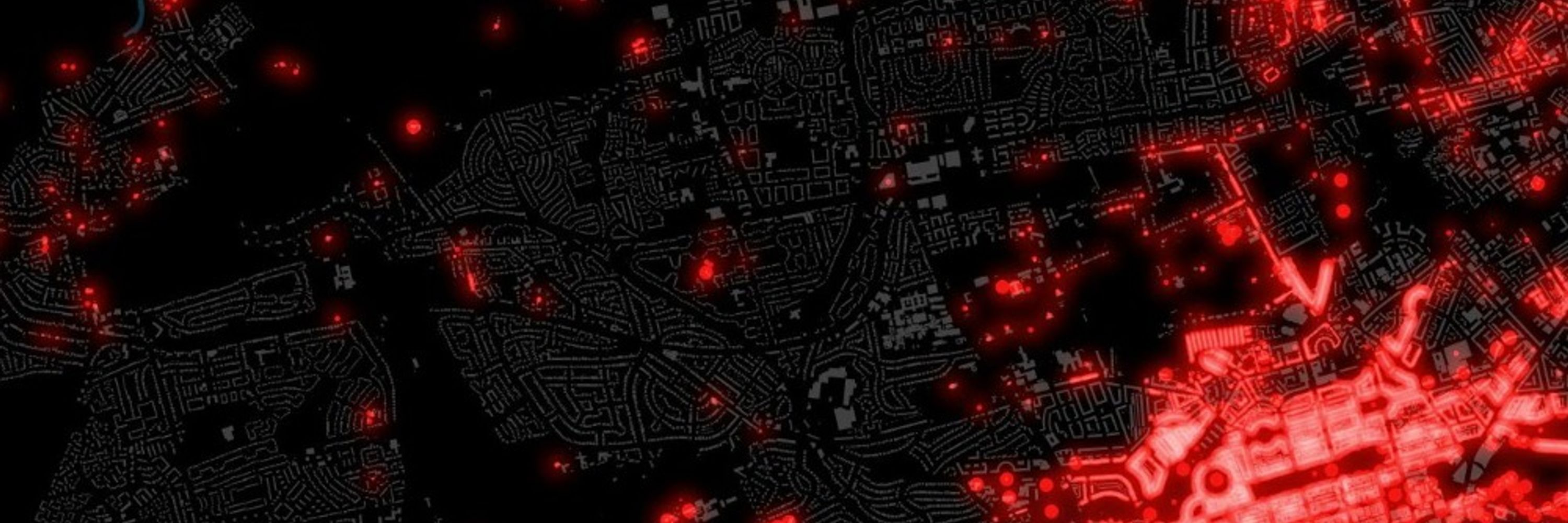
Incredible visual journalism! 📰 Check out how MapTiler was used by Radio Free Europe/Radio Liberty in their deep investigation, mapping the military infrastructure in Lukashenko’s Belarus.
November 11, 2025 at 4:02 PM
Incredible visual journalism! 📰 Check out how MapTiler was used by Radio Free Europe/Radio Liberty in their deep investigation, mapping the military infrastructure in Lukashenko’s Belarus.
Reposted by Tom Armitage
Our latest monthly geocoding update focused mainly on adding streets with address points (now up to 30 million) and points of interest (increased to 58 million). Our database now has nearly 106 million features in total!
Explore the spatial search: maptiler.link/4oviFme
Explore the spatial search: maptiler.link/4oviFme
November 10, 2025 at 4:00 PM
Our latest monthly geocoding update focused mainly on adding streets with address points (now up to 30 million) and points of interest (increased to 58 million). Our database now has nearly 106 million features in total!
Explore the spatial search: maptiler.link/4oviFme
Explore the spatial search: maptiler.link/4oviFme
Reposted by Tom Armitage
Customize map animation effects to enhance the user experience! You can set the speed and other parameters on effects like making the terrain “grow”.
Master this effect and more with our documentation: maptiler.link/4ovuDfS
Master this effect and more with our documentation: maptiler.link/4ovuDfS
November 7, 2025 at 4:15 PM
Customize map animation effects to enhance the user experience! You can set the speed and other parameters on effects like making the terrain “grow”.
Master this effect and more with our documentation: maptiler.link/4ovuDfS
Master this effect and more with our documentation: maptiler.link/4ovuDfS
Reposted by Tom Armitage
It's #GLOW2025 day! 💡✨ The spectacular light art festival in Eindhoven starts now, celebrating its 20th anniversary! 🎉
We're proud to provide the maps to guide you through the stunning national & international light artworks. Grab your loved ones and experience the magic!
We're proud to provide the maps to guide you through the stunning national & international light artworks. Grab your loved ones and experience the magic!


November 8, 2025 at 4:00 PM
It's #GLOW2025 day! 💡✨ The spectacular light art festival in Eindhoven starts now, celebrating its 20th anniversary! 🎉
We're proud to provide the maps to guide you through the stunning national & international light artworks. Grab your loved ones and experience the magic!
We're proud to provide the maps to guide you through the stunning national & international light artworks. Grab your loved ones and experience the magic!
Reposted by Tom Armitage

The biggest SECRET your SEO-guy never tells you about.
How to easily get your business on other maps than google maps.
#BusinessGrowth #DigitalMarketing #SEO #LocalSEO #Marketing #sales
How to easily get your business on other maps than google maps.
#BusinessGrowth #DigitalMarketing #SEO #LocalSEO #Marketing #sales
Want a better #map for everyone? Contribute to #OpenStreetMap!
Add shops, companies, or paths with with easy apps like mapcomplete.org, Go Map!! or Every Door:
🍏 apps.apple.com/nl/app/every...
🤖 play.google.com/store/apps/d...
Quick, fun, and for everyone.🚶♀️📍
#MapForAll #OSM #shopping #sales
Add shops, companies, or paths with with easy apps like mapcomplete.org, Go Map!! or Every Door:
🍏 apps.apple.com/nl/app/every...
🤖 play.google.com/store/apps/d...
Quick, fun, and for everyone.🚶♀️📍
#MapForAll #OSM #shopping #sales

Every Door
This editor does not make you think. Just go to a mall, and start Every Door. You'll see mapped shops around you: tap on the checkmark for any that are still there, and add shops that are not on the ...
apps.apple.com
October 27, 2025 at 10:16 AM
The biggest SECRET your SEO-guy never tells you about.
How to easily get your business on other maps than google maps.
#BusinessGrowth #DigitalMarketing #SEO #LocalSEO #Marketing #sales
How to easily get your business on other maps than google maps.
#BusinessGrowth #DigitalMarketing #SEO #LocalSEO #Marketing #sales
Reposted by Tom Armitage
Want realistic weather maps? 🌎 See hurricanes & large storms on a globe, discover how geography affects weather, and compare temperatures across continents.
Find out more at maptiler.link/4nk4gZm
Find out more at maptiler.link/4nk4gZm
November 6, 2025 at 5:30 PM
Want realistic weather maps? 🌎 See hurricanes & large storms on a globe, discover how geography affects weather, and compare temperatures across continents.
Find out more at maptiler.link/4nk4gZm
Find out more at maptiler.link/4nk4gZm
Reposted by Tom Armitage
We're supporting Jimmy Pelletier's incredible 40,000 km World Tour! 🌍🚴
He's cycling across 5 continents & 27 countries to raise funds for people with disabilities. Track his journey (Stage 3 in progress!) on the interactive map: maptiler.link/47YDvof
He's cycling across 5 continents & 27 countries to raise funds for people with disabilities. Track his journey (Stage 3 in progress!) on the interactive map: maptiler.link/47YDvof
November 5, 2025 at 4:00 PM
We're supporting Jimmy Pelletier's incredible 40,000 km World Tour! 🌍🚴
He's cycling across 5 continents & 27 countries to raise funds for people with disabilities. Track his journey (Stage 3 in progress!) on the interactive map: maptiler.link/47YDvof
He's cycling across 5 continents & 27 countries to raise funds for people with disabilities. Track his journey (Stage 3 in progress!) on the interactive map: maptiler.link/47YDvof
Reposted by Tom Armitage

Less than two weeks to go until Geomob Belgium 🇧🇪 on November 18th, this time in Antwerp!
Great line-up of speakers thanks to organizers Han Tambuyzer of Nazzka Mapps and Ben Abelshausen of Anyways. Thank you to Buurtcentrum Cortina for hosting the event.
Great line-up of speakers thanks to organizers Han Tambuyzer of Nazzka Mapps and Ben Abelshausen of Anyways. Thank you to Buurtcentrum Cortina for hosting the event.


November 5, 2025 at 3:29 PM
Less than two weeks to go until Geomob Belgium 🇧🇪 on November 18th, this time in Antwerp!
Great line-up of speakers thanks to organizers Han Tambuyzer of Nazzka Mapps and Ben Abelshausen of Anyways. Thank you to Buurtcentrum Cortina for hosting the event.
Great line-up of speakers thanks to organizers Han Tambuyzer of Nazzka Mapps and Ben Abelshausen of Anyways. Thank you to Buurtcentrum Cortina for hosting the event.
Reposted by Tom Armitage

It's been a while, but I'm doing a little public talk again soon
Less than two weeks to go until Geomob Belgium 🇧🇪 on November 18th, this time in Antwerp!
Great line-up of speakers thanks to organizers Han Tambuyzer of Nazzka Mapps and Ben Abelshausen of Anyways. Thank you to Buurtcentrum Cortina for hosting the event.
Great line-up of speakers thanks to organizers Han Tambuyzer of Nazzka Mapps and Ben Abelshausen of Anyways. Thank you to Buurtcentrum Cortina for hosting the event.
November 5, 2025 at 4:00 PM
It's been a while, but I'm doing a little public talk again soon
Reposted by Tom Armitage
Learn about the map designer and how to customize your maps here: maptiler.link/3JsW5M3
#WebMaps #Maps# Cartography
#WebMaps #Maps# Cartography

Customizable map designs to fit your project
Customize colors, fonts, language & more with an easy to use editor for map designers & software developers.
maptiler.link
November 4, 2025 at 4:00 PM
Learn about the map designer and how to customize your maps here: maptiler.link/3JsW5M3
#WebMaps #Maps# Cartography
#WebMaps #Maps# Cartography
Reposted by Tom Armitage
The easiest-to-use cartography tool on the web! Martin Elias shared all the details about the MapTiler map designer at #Connect25, explaining why it’s so intuitive. Find out what it can do; the link is in the first reply.
#WebMaps #Cartography #Maps
#WebMaps #Cartography #Maps


November 4, 2025 at 4:00 PM
The easiest-to-use cartography tool on the web! Martin Elias shared all the details about the MapTiler map designer at #Connect25, explaining why it’s so intuitive. Find out what it can do; the link is in the first reply.
#WebMaps #Cartography #Maps
#WebMaps #Cartography #Maps
Reposted by Tom Armitage

#30DayMapChallenge day 2: Lines 🗺️ Mapped Rotterdam’s watery past through street names with pre- and suffixes like singel, boezem, sloot, vaart, haven, and gedempte. These names trace water infrastructure. Some still flowing, others filled in.
Made with #qgis #openstreetmap and #maptiler
Made with #qgis #openstreetmap and #maptiler

November 2, 2025 at 8:20 AM
#30DayMapChallenge day 2: Lines 🗺️ Mapped Rotterdam’s watery past through street names with pre- and suffixes like singel, boezem, sloot, vaart, haven, and gedempte. These names trace water infrastructure. Some still flowing, others filled in.
Made with #qgis #openstreetmap and #maptiler
Made with #qgis #openstreetmap and #maptiler
Reposted by Tom Armitage
Maps in web applications with MapTiler:
blog.rasc.ch/2025/07/mapt...
www.maptiler.com
#javascript #maptiler
blog.rasc.ch/2025/07/mapt...
www.maptiler.com
#javascript #maptiler

Embedding maps with MapTiler in a web application
In a previous blog post, I showed you how to write a web application that displays photos on a map. The article demonstrated how to extract GPS coordinates and then display a marker for each photo on Google Maps.
blog.rasc.ch
November 3, 2025 at 7:12 AM
Maps in web applications with MapTiler:
blog.rasc.ch/2025/07/mapt...
www.maptiler.com
#javascript #maptiler
blog.rasc.ch/2025/07/mapt...
www.maptiler.com
#javascript #maptiler
Reposted by Tom Armitage
Discover Lithuania in stunning 20 cm detail! The latest high-resolution satellite imagery now brings every building, road, and even individual trees into focus.
Explore the entire country from above on the MapTiler satellite map and see every feature with exceptional clarity: maptiler.link/4q1kLeQ
Explore the entire country from above on the MapTiler satellite map and see every feature with exceptional clarity: maptiler.link/4q1kLeQ

November 3, 2025 at 4:03 PM
Discover Lithuania in stunning 20 cm detail! The latest high-resolution satellite imagery now brings every building, road, and even individual trees into focus.
Explore the entire country from above on the MapTiler satellite map and see every feature with exceptional clarity: maptiler.link/4q1kLeQ
Explore the entire country from above on the MapTiler satellite map and see every feature with exceptional clarity: maptiler.link/4q1kLeQ
Reposted by Tom Armitage
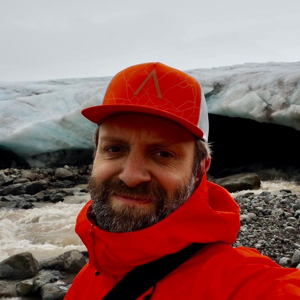
Had a great time with MapTiler team at Connect 2025!
Truly inspiring to see what is being built and delivered. Also great to get a chance to give positive feedback from us at The Icelandic Met Office
Truly inspiring to see what is being built and delivered. Also great to get a chance to give positive feedback from us at The Icelandic Met Office
The MapTiler Open Foundation ❤️ What a highlight of MapTiler #Connect25!
Our CEO, Petr Pridal, just announced how we're doubling down on supporting the open-source community.
Read all about it: maptiler.link/4nWw1I5 #opensource
Our CEO, Petr Pridal, just announced how we're doubling down on supporting the open-source community.
Read all about it: maptiler.link/4nWw1I5 #opensource

October 21, 2025 at 7:58 PM
Had a great time with MapTiler team at Connect 2025!
Truly inspiring to see what is being built and delivered. Also great to get a chance to give positive feedback from us at The Icelandic Met Office
Truly inspiring to see what is being built and delivered. Also great to get a chance to give positive feedback from us at The Icelandic Met Office
Reposted by Tom Armitage
Explore on-prem maps in 3 simple steps! We’ve made it super easy to host the amazing #maps you can download for your on-prem applications. Just follow the steps that appear when you are downloading your maps. Find out more via the link in the first reply!
#OnPrem #SelfHosting
#OnPrem #SelfHosting

October 30, 2025 at 4:00 PM
Explore on-prem maps in 3 simple steps! We’ve made it super easy to host the amazing #maps you can download for your on-prem applications. Just follow the steps that appear when you are downloading your maps. Find out more via the link in the first reply!
#OnPrem #SelfHosting
#OnPrem #SelfHosting
Reposted by Tom Armitage
👻 Happy Halloween from MapTiler! 🎃
We’ve brewed up something spooky for #map lovers: creepy icons on placenames that scream Halloween — bats, pumpkins, devils, & more.
Explore… if you dare, the link is in the first reply!
#Halloween #Cartography #SpookyMaps #WebMaps
We’ve brewed up something spooky for #map lovers: creepy icons on placenames that scream Halloween — bats, pumpkins, devils, & more.
Explore… if you dare, the link is in the first reply!
#Halloween #Cartography #SpookyMaps #WebMaps
October 31, 2025 at 4:05 PM
👻 Happy Halloween from MapTiler! 🎃
We’ve brewed up something spooky for #map lovers: creepy icons on placenames that scream Halloween — bats, pumpkins, devils, & more.
Explore… if you dare, the link is in the first reply!
#Halloween #Cartography #SpookyMaps #WebMaps
We’ve brewed up something spooky for #map lovers: creepy icons on placenames that scream Halloween — bats, pumpkins, devils, & more.
Explore… if you dare, the link is in the first reply!
#Halloween #Cartography #SpookyMaps #WebMaps
Reposted by Tom Armitage
Enhance your maps with dynamic animated weather layers 🌦️ Experience smooth visualizations powered by your own data or MapTiler's global forecasts. Try it today: maptiler.link/3I7MjOx
October 29, 2025 at 4:09 PM
Enhance your maps with dynamic animated weather layers 🌦️ Experience smooth visualizations powered by your own data or MapTiler's global forecasts. Try it today: maptiler.link/3I7MjOx
Reposted by Tom Armitage

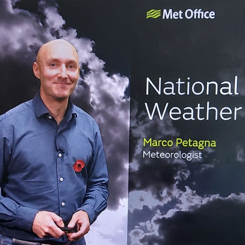
On the dullest of late October days, the solar panels are still generating 1/3 of the power required to keep the heat pump ticking over to maintain the house at a comfortable 21C. The battery, charged up on cheap overnight rate, is providing the rest.

October 29, 2025 at 11:17 AM
On the dullest of late October days, the solar panels are still generating 1/3 of the power required to keep the heat pump ticking over to maintain the house at a comfortable 21C. The battery, charged up on cheap overnight rate, is providing the rest.
Reposted by Tom Armitage
See Estonia on a satellite map in stunning detail.
Urban areas are captured at 10 cm/px resolution to make every street and building crystal clear. The rest of the country is covered at 20 cm/px, ensuring sharp imagery everywhere.
Read more: maptiler.link/4mtjHh0
Urban areas are captured at 10 cm/px resolution to make every street and building crystal clear. The rest of the country is covered at 20 cm/px, ensuring sharp imagery everywhere.
Read more: maptiler.link/4mtjHh0
October 27, 2025 at 4:08 PM
See Estonia on a satellite map in stunning detail.
Urban areas are captured at 10 cm/px resolution to make every street and building crystal clear. The rest of the country is covered at 20 cm/px, ensuring sharp imagery everywhere.
Read more: maptiler.link/4mtjHh0
Urban areas are captured at 10 cm/px resolution to make every street and building crystal clear. The rest of the country is covered at 20 cm/px, ensuring sharp imagery everywhere.
Read more: maptiler.link/4mtjHh0
Reposted by Tom Armitage
#Melissa a staggering cat 5 hurricane 🌀& strengthening
Sustained winds 160mph gusts 200mph
Central pressure 913hpa
The Caribbean, notably Jamaica expecting catastrophic damage from this very slow 🐌 moving storm
1000mm rain possible..London gets ~600/yr!
13ft storm surge
Sustained winds 160mph gusts 200mph
Central pressure 913hpa
The Caribbean, notably Jamaica expecting catastrophic damage from this very slow 🐌 moving storm
1000mm rain possible..London gets ~600/yr!
13ft storm surge

October 27, 2025 at 12:39 PM
#Melissa a staggering cat 5 hurricane 🌀& strengthening
Sustained winds 160mph gusts 200mph
Central pressure 913hpa
The Caribbean, notably Jamaica expecting catastrophic damage from this very slow 🐌 moving storm
1000mm rain possible..London gets ~600/yr!
13ft storm surge
Sustained winds 160mph gusts 200mph
Central pressure 913hpa
The Caribbean, notably Jamaica expecting catastrophic damage from this very slow 🐌 moving storm
1000mm rain possible..London gets ~600/yr!
13ft storm surge
Reposted by Tom Armitage
That's a wrap on MapTiler #Connect25! What an event.
Highlights:
✅ All-new map styles
✅ Groundbreaking GeoSplats
✅ New mobile SDK
✅ Launch of the MapTiler Open Foundation
A massive thank you to our speakers & all attendees (online & in Zurich). You made it all possible!
Highlights:
✅ All-new map styles
✅ Groundbreaking GeoSplats
✅ New mobile SDK
✅ Launch of the MapTiler Open Foundation
A massive thank you to our speakers & all attendees (online & in Zurich). You made it all possible!


October 23, 2025 at 5:00 PM
That's a wrap on MapTiler #Connect25! What an event.
Highlights:
✅ All-new map styles
✅ Groundbreaking GeoSplats
✅ New mobile SDK
✅ Launch of the MapTiler Open Foundation
A massive thank you to our speakers & all attendees (online & in Zurich). You made it all possible!
Highlights:
✅ All-new map styles
✅ Groundbreaking GeoSplats
✅ New mobile SDK
✅ Launch of the MapTiler Open Foundation
A massive thank you to our speakers & all attendees (online & in Zurich). You made it all possible!