


Joackiie
@joackiie.bsky.social
Senior meteorologist (M. Sc.), retired 😊
Passionate about all weather and science. Hiking and skiing.
Passionate about all weather and science. Hiking and skiing.
Reposted by Joackiie

1 year, half a billion flashes, and storms revealed like never before. Our Lightning Imager is transforming how meteorologists can now track & forecast lightning from space. 🌩️
In our latest article, EUMETSAT’s Sven-Erik Enno reflects on the LI’s impacts after its first full year: bit.ly/4alc9tJ
In our latest article, EUMETSAT’s Sven-Erik Enno reflects on the LI’s impacts after its first full year: bit.ly/4alc9tJ
January 29, 2026 at 12:22 PM
1 year, half a billion flashes, and storms revealed like never before. Our Lightning Imager is transforming how meteorologists can now track & forecast lightning from space. 🌩️
In our latest article, EUMETSAT’s Sven-Erik Enno reflects on the LI’s impacts after its first full year: bit.ly/4alc9tJ
In our latest article, EUMETSAT’s Sven-Erik Enno reflects on the LI’s impacts after its first full year: bit.ly/4alc9tJ
Reposted by Joackiie

How unusual is this upcoming cold outbreak in Florida? Per the latest forecast, the cold airmass aloft is within 1-2 degrees Celsius of the **year-round** cold record from 1950-2024:

January 29, 2026 at 3:31 PM
How unusual is this upcoming cold outbreak in Florida? Per the latest forecast, the cold airmass aloft is within 1-2 degrees Celsius of the **year-round** cold record from 1950-2024:
Reposted by Joackiie

Following the devastating winter storm last weekend, many people across the South were left without power, as can be seen in this nighttime visible imagery.
January 28, 2026 at 8:51 PM
Following the devastating winter storm last weekend, many people across the South were left without power, as can be seen in this nighttime visible imagery.
Reposted by Joackiie

Sea Surface Temperature around Europe were record high again in 2025.
No one can (falsely) blame El Niño for this.
No one can (falsely) blame El Niño for this.

January 23, 2026 at 1:20 PM
Sea Surface Temperature around Europe were record high again in 2025.
No one can (falsely) blame El Niño for this.
No one can (falsely) blame El Niño for this.
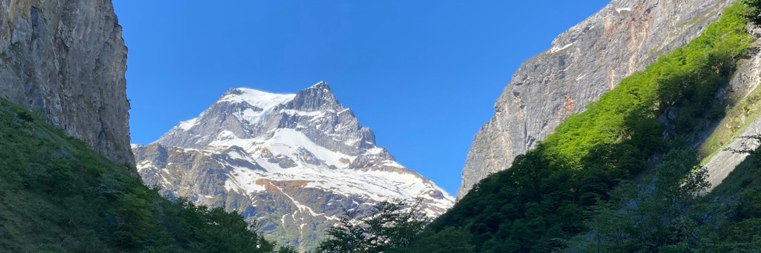
Clear sky over the Alps, snow red colored.
At Zurich Airport (LSZH), cold fog is dissipating, coinciding with the approach of a United States Air Force aircraft.
Over Italy, dense high-altitude cloud cover, with the presence of Saharan dust exhibiting typical rippled cloud-tops.
At Zurich Airport (LSZH), cold fog is dissipating, coinciding with the approach of a United States Air Force aircraft.
Over Italy, dense high-altitude cloud cover, with the presence of Saharan dust exhibiting typical rippled cloud-tops.

January 21, 2026 at 10:40 AM
Clear sky over the Alps, snow red colored.
At Zurich Airport (LSZH), cold fog is dissipating, coinciding with the approach of a United States Air Force aircraft.
Over Italy, dense high-altitude cloud cover, with the presence of Saharan dust exhibiting typical rippled cloud-tops.
At Zurich Airport (LSZH), cold fog is dissipating, coinciding with the approach of a United States Air Force aircraft.
Over Italy, dense high-altitude cloud cover, with the presence of Saharan dust exhibiting typical rippled cloud-tops.
Reposted by Joackiie

DIBS (dust‐infused baroclinic storm) clouds seen over Croatia this morning in the Met-12 Day Snow Fog RGB, via EUMETView (view.eumetsat.int) and Jochen Kerkmann. See our guide exploring dust clouds in satellite imagery user.eumetsat.int/resources/us...

January 21, 2026 at 9:16 AM
DIBS (dust‐infused baroclinic storm) clouds seen over Croatia this morning in the Met-12 Day Snow Fog RGB, via EUMETView (view.eumetsat.int) and Jochen Kerkmann. See our guide exploring dust clouds in satellite imagery user.eumetsat.int/resources/us...
Preliminary forecasts suggest that January is likely to be significantly colder than average across Northern and Eastern Europe.
Initial projections for February 2026, compiled from 13 meteorological centres, indicate ↘️
Initial projections for February 2026, compiled from 13 meteorological centres, indicate ↘️


January 20, 2026 at 8:04 PM
Preliminary forecasts suggest that January is likely to be significantly colder than average across Northern and Eastern Europe.
Initial projections for February 2026, compiled from 13 meteorological centres, indicate ↘️
Initial projections for February 2026, compiled from 13 meteorological centres, indicate ↘️
Reposted by Joackiie

Europe temperature categories for the full year (2025). Seems bad.

January 18, 2026 at 8:02 PM
Europe temperature categories for the full year (2025). Seems bad.
Low stratus blankets the northern Alps today, pushing into pre-Alpine valleys with a ceiling of ~800m (Rigi webcam); valley shape+exposure matter more than the fog’s height.
Alpine valleys have foehn with up to 14°C, the southern Alps have thick cloud (but little rain), spilling over the main ridge
Alpine valleys have foehn with up to 14°C, the southern Alps have thick cloud (but little rain), spilling over the main ridge


January 18, 2026 at 11:31 AM
Low stratus blankets the northern Alps today, pushing into pre-Alpine valleys with a ceiling of ~800m (Rigi webcam); valley shape+exposure matter more than the fog’s height.
Alpine valleys have foehn with up to 14°C, the southern Alps have thick cloud (but little rain), spilling over the main ridge
Alpine valleys have foehn with up to 14°C, the southern Alps have thick cloud (but little rain), spilling over the main ridge
Reposted by Joackiie
Over 50% of the Earth has experienced their warmest year since 2021!

January 17, 2026 at 5:26 AM
Over 50% of the Earth has experienced their warmest year since 2021!
Reposted by Joackiie
Let's check in a see which year since 1940 was the warmest and which one was the coldest for all of the Earth. Red colors are closest to 2025, and blue colors are closest to 1940. I spot a slight difference.


January 17, 2026 at 5:21 AM
Let's check in a see which year since 1940 was the warmest and which one was the coldest for all of the Earth. Red colors are closest to 2025, and blue colors are closest to 1940. I spot a slight difference.
The first half of the first month of the new year was also too cold across Europe (according to the JMA).
The latest ECMWF weekly forecasts show the cold weather continuing over the coming week 4 and 5...
The latest ECMWF weekly forecasts show the cold weather continuing over the coming week 4 and 5...


January 16, 2026 at 4:12 PM
The first half of the first month of the new year was also too cold across Europe (according to the JMA).
The latest ECMWF weekly forecasts show the cold weather continuing over the coming week 4 and 5...
The latest ECMWF weekly forecasts show the cold weather continuing over the coming week 4 and 5...
Partly persistent low, cold (Zurich area highs only 1°C) dense fog over Swiss plateau, as seen by NOAA21 at 12h03 UTC.
Alpine foehn valleys on the other hand up to 15°C.
Dense high/midlevel clouds from south, even with dust from Sahara and Sahel!
Alpine foehn valleys on the other hand up to 15°C.
Dense high/midlevel clouds from south, even with dust from Sahara and Sahel!


January 16, 2026 at 3:34 PM
Partly persistent low, cold (Zurich area highs only 1°C) dense fog over Swiss plateau, as seen by NOAA21 at 12h03 UTC.
Alpine foehn valleys on the other hand up to 15°C.
Dense high/midlevel clouds from south, even with dust from Sahara and Sahel!
Alpine foehn valleys on the other hand up to 15°C.
Dense high/midlevel clouds from south, even with dust from Sahara and Sahel!
Reposted by Joackiie

Hundreds of US scientists who have worked on Greenland have signed a letter rejecting US President Donald Trump's push for control over Greenland. "We vehemently oppose President Trump’s aggressive stance regarding Greenland," the letter reads.
www.highnorthnews.com/en/us-resear...
www.highnorthnews.com/en/us-resear...

US Researchers in Greenland Reject Trump’s Expansionist Ambitions
Hundreds of US scientists who have worked on Greenland have signed a letter rejecting US President Donald Trump's push for control over Greenland. "We vehemently oppose President Trump’s aggressive st...
www.highnorthnews.com
January 16, 2026 at 12:25 PM
Hundreds of US scientists who have worked on Greenland have signed a letter rejecting US President Donald Trump's push for control over Greenland. "We vehemently oppose President Trump’s aggressive stance regarding Greenland," the letter reads.
www.highnorthnews.com/en/us-resear...
www.highnorthnews.com/en/us-resear...
Storm Goretii (Elli) brought significant snowfall to central Europe, covering now 99% of Germany—except the Rhine valley. Climatological maximum is typically 40–45% snow cover end of January.
However, this snow is forecast to melt within the week...
However, this snow is forecast to melt within the week...

January 12, 2026 at 12:37 PM
Storm Goretii (Elli) brought significant snowfall to central Europe, covering now 99% of Germany—except the Rhine valley. Climatological maximum is typically 40–45% snow cover end of January.
However, this snow is forecast to melt within the week...
However, this snow is forecast to melt within the week...
First 10 days of the new year were too cold all over Europe (JMA).
But next two weeks milder weather will prevail (by ECMWF)
But next two weeks milder weather will prevail (by ECMWF)


January 11, 2026 at 9:02 AM
First 10 days of the new year were too cold all over Europe (JMA).
But next two weeks milder weather will prevail (by ECMWF)
But next two weeks milder weather will prevail (by ECMWF)
Baroclinic zone—juxtaposing subtropical air (SW) and Arctic air (NW)—will spawn a cyclogenesis SW of Ireland Thursday morning. Rapid deepening (bombogenesis) will reduce MSLP to ~970 hPa by 00 UTC Friday (cyclone ‘Goretti’ by Météo-France). With strong westerly winds temporary thaw in western Europe

January 6, 2026 at 12:23 PM
Baroclinic zone—juxtaposing subtropical air (SW) and Arctic air (NW)—will spawn a cyclogenesis SW of Ireland Thursday morning. Rapid deepening (bombogenesis) will reduce MSLP to ~970 hPa by 00 UTC Friday (cyclone ‘Goretti’ by Météo-France). With strong westerly winds temporary thaw in western Europe
The calendar year 2025 was the third warmest globally and in Europe since 1940, according to ERA5 data.
Thx to @climatologist49.bsky.social
Thx to @climatologist49.bsky.social


January 5, 2026 at 11:57 AM
The calendar year 2025 was the third warmest globally and in Europe since 1940, according to ERA5 data.
Thx to @climatologist49.bsky.social
Thx to @climatologist49.bsky.social
Reposted by Joackiie
Antarctica had its warmest year on record. That seems fucking bad. 🔥🔥🔥

January 5, 2026 at 6:00 AM
Antarctica had its warmest year on record. That seems fucking bad. 🔥🔥🔥
Central Europe has finally received fresh snow.
With arctic air mass and clear skies widespread severe chill are expected Sunday night, with some Alpine valleys reaching −30°C!
The cold wave persists until Thursday, after which stormy westerly winds will introduce again milder atlantic air.
With arctic air mass and clear skies widespread severe chill are expected Sunday night, with some Alpine valleys reaching −30°C!
The cold wave persists until Thursday, after which stormy westerly winds will introduce again milder atlantic air.


January 3, 2026 at 11:21 AM
Central Europe has finally received fresh snow.
With arctic air mass and clear skies widespread severe chill are expected Sunday night, with some Alpine valleys reaching −30°C!
The cold wave persists until Thursday, after which stormy westerly winds will introduce again milder atlantic air.
With arctic air mass and clear skies widespread severe chill are expected Sunday night, with some Alpine valleys reaching −30°C!
The cold wave persists until Thursday, after which stormy westerly winds will introduce again milder atlantic air.
The dryest month in Europe on average is - according to ERA5 reanalysis data:

December 31, 2025 at 12:38 PM
The dryest month in Europe on average is - according to ERA5 reanalysis data:
With a surge of arctic air from Greenland/Canada Switzerland experiences a sunny last day of the year 2025.
Extremely dry air (dew points ~−7°C) inhibited low stratus/fog, but widespread frost developed.
Alpine valleys with snow (red-flagged) had temperatures plunging to −23°C!
Extremely dry air (dew points ~−7°C) inhibited low stratus/fog, but widespread frost developed.
Alpine valleys with snow (red-flagged) had temperatures plunging to −23°C!

December 31, 2025 at 9:41 AM
With a surge of arctic air from Greenland/Canada Switzerland experiences a sunny last day of the year 2025.
Extremely dry air (dew points ~−7°C) inhibited low stratus/fog, but widespread frost developed.
Alpine valleys with snow (red-flagged) had temperatures plunging to −23°C!
Extremely dry air (dew points ~−7°C) inhibited low stratus/fog, but widespread frost developed.
Alpine valleys with snow (red-flagged) had temperatures plunging to −23°C!
Reposted by Joackiie
Vielleicht schaffen wir es zumindest, Waldbrände nicht nur auf Brandstiftung zurückzuführen. 12jährige, die Feuerwerkskörper zünden, gab es immer schon. Extreme Trockenheit, die daraus Waldbrände macht, ist hingegen eher neu. Guter Journalismus würde das einordnen. www.derstandard.at/story/300000...

Waldbrand auf Innsbrucker Nordkette: Bub offenbar für Feuer verantwortlich
Am frühen Nachmittag war das Feuer weiter unter Kontrolle, die Einsatzkräfte aber noch mit dem Löschen einer "Vielzahl an Glutnestern" beschäftigt
www.derstandard.at
December 28, 2025 at 2:19 PM
Vielleicht schaffen wir es zumindest, Waldbrände nicht nur auf Brandstiftung zurückzuführen. 12jährige, die Feuerwerkskörper zünden, gab es immer schon. Extreme Trockenheit, die daraus Waldbrände macht, ist hingegen eher neu. Guter Journalismus würde das einordnen. www.derstandard.at/story/300000...
Under high pressure, the Alps will experience dry, often sunny and clear weather. In the north and southeast, persistent low stratus cloud may linger over low-lying areas.
Snow cover (shown in blue) is more extensive than usual for this time of year.
Snow cover (shown in blue) is more extensive than usual for this time of year.


December 29, 2025 at 2:31 PM
Under high pressure, the Alps will experience dry, often sunny and clear weather. In the north and southeast, persistent low stratus cloud may linger over low-lying areas.
Snow cover (shown in blue) is more extensive than usual for this time of year.
Snow cover (shown in blue) is more extensive than usual for this time of year.
Cold freezing fog persists over Swiss Plateau below ~1000 m a.s.l.
Above, sunny, very dry and again very warm (freezing level ~3500 m).
Extreme warmth on the southern Alps, enhanced by northerly föhn effects.
Above, sunny, very dry and again very warm (freezing level ~3500 m).
Extreme warmth on the southern Alps, enhanced by northerly föhn effects.


December 28, 2025 at 9:21 AM
Cold freezing fog persists over Swiss Plateau below ~1000 m a.s.l.
Above, sunny, very dry and again very warm (freezing level ~3500 m).
Extreme warmth on the southern Alps, enhanced by northerly föhn effects.
Above, sunny, very dry and again very warm (freezing level ~3500 m).
Extreme warmth on the southern Alps, enhanced by northerly föhn effects.