


Joackiie
@joackiie.bsky.social
Senior meteorologist (M. Sc.), retired 😊
Passionate about all weather and science. Hiking and skiing.
Passionate about all weather and science. Hiking and skiing.
This dust pocket developed yesterday afternoon in north-western Algeria and is currently at an approximate altitude of 2–3 km (Ceilometer, Menorca).

November 13, 2025 at 11:58 AM
This dust pocket developed yesterday afternoon in north-western Algeria and is currently at an approximate altitude of 2–3 km (Ceilometer, Menorca).
Despite the impressively cold conditions anticipated across Central Europe next week: all available models indicate that the winter of 2025/2026 (1 December to 28 February) is expected to be overall warmer than average.


November 13, 2025 at 10:28 AM
Despite the impressively cold conditions anticipated across Central Europe next week: all available models indicate that the winter of 2025/2026 (1 December to 28 February) is expected to be overall warmer than average.
Despite a robust boundary-layer inversion exceeding 10K, fog was notably absent this morning over the Swiss Plateau. Persistent dense high cloud cover remained, while MTG imagery revealed dense Saharan dust-cloud near the Balearics—most accurately depicted by the Monarch and Met Office UM models.


November 13, 2025 at 8:32 AM
Despite a robust boundary-layer inversion exceeding 10K, fog was notably absent this morning over the Swiss Plateau. Persistent dense high cloud cover remained, while MTG imagery revealed dense Saharan dust-cloud near the Balearics—most accurately depicted by the Monarch and Met Office UM models.
Beneath dense, yet transparent cirrus clouds at high altitude (10–12 km, as recorded by the Payerne ceilometer), persistent fog blanketed the Swiss Plateau until midday. This was capped by a pronounced temperature inversion (10 K) and, notably, remained confined to the Lake Constance basin.


November 12, 2025 at 11:57 AM
Beneath dense, yet transparent cirrus clouds at high altitude (10–12 km, as recorded by the Payerne ceilometer), persistent fog blanketed the Swiss Plateau until midday. This was capped by a pronounced temperature inversion (10 K) and, notably, remained confined to the Lake Constance basin.
Polar light, aurora last night seen from below (eastern Switzerland, starting 02 UTC) and from above (SNPP, day/night band).


November 12, 2025 at 7:15 AM
Polar light, aurora last night seen from below (eastern Switzerland, starting 02 UTC) and from above (SNPP, day/night band).
Snow cover in the Swiss Alps remains around average, but with record warmth expected over the next few days — a freezing level rising to around 3,500 m — it is likely to decrease significantly.
Beyond that, however, there is considerable uncertainty (according to the GFS ensemble) 🤔
Beyond that, however, there is considerable uncertainty (according to the GFS ensemble) 🤔


November 10, 2025 at 9:16 PM
Snow cover in the Swiss Alps remains around average, but with record warmth expected over the next few days — a freezing level rising to around 3,500 m — it is likely to decrease significantly.
Beyond that, however, there is considerable uncertainty (according to the GFS ensemble) 🤔
Beyond that, however, there is considerable uncertainty (according to the GFS ensemble) 🤔
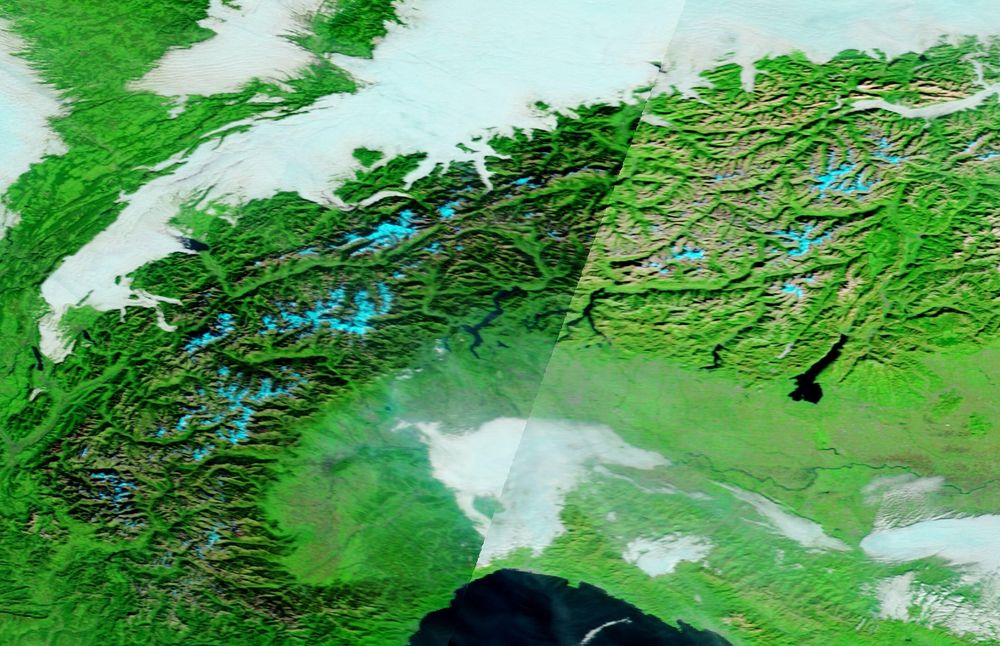
A midday Terra/MODIS (NASA) satellite image from Saturday reveals cloudless, snow-covered (blue-tinted) Alpine region, with fog/low stratus blanketing adjacent lowland plateau between Lake of Geneva and Constance and with a top of 700-800m partially inundating prealpine valleys.

November 8, 2025 at 1:35 PM
A midday Terra/MODIS (NASA) satellite image from Saturday reveals cloudless, snow-covered (blue-tinted) Alpine region, with fog/low stratus blanketing adjacent lowland plateau between Lake of Geneva and Constance and with a top of 700-800m partially inundating prealpine valleys.
For the calendar year 2025 to date (January–October), global temperatures rank as the second warmest in the ERA5 record (since 1940), with Europe experiencing its third warmest such period.


November 8, 2025 at 9:45 AM
For the calendar year 2025 to date (January–October), global temperatures rank as the second warmest in the ERA5 record (since 1940), with Europe experiencing its third warmest such period.
Typical autumnal satellite imagery with fog over the Swiss Plateau. An atypical anticyclonic southerly föhn is sweeping across the Alps: no clouds to the south, yet amid small pressure difference gusts of 60 (Hasli Valley) to 106 km/h and temperatures of 20°C in Elm+Brig - beneath the fog just 4°C


November 6, 2025 at 12:30 PM
Typical autumnal satellite imagery with fog over the Swiss Plateau. An atypical anticyclonic southerly föhn is sweeping across the Alps: no clouds to the south, yet amid small pressure difference gusts of 60 (Hasli Valley) to 106 km/h and temperatures of 20°C in Elm+Brig - beneath the fog just 4°C
October 2025 was globally 3rd warmest since 1940.
Kudos to @climatologist49.bsky.social
Kudos to @climatologist49.bsky.social


November 5, 2025 at 5:22 AM
October 2025 was globally 3rd warmest since 1940.
Kudos to @climatologist49.bsky.social
Kudos to @climatologist49.bsky.social
Settled, dry, and often fine autumnal weather prevails across central Europe.
Meanwhile, a record-breaking extratropical cyclone—termed a “weather bomb”—has intensified near Newfoundland, with a minimum central pressure of 943 hPa recorded on Wednesday morning.
Meanwhile, a record-breaking extratropical cyclone—termed a “weather bomb”—has intensified near Newfoundland, with a minimum central pressure of 943 hPa recorded on Wednesday morning.


November 4, 2025 at 4:08 PM
Settled, dry, and often fine autumnal weather prevails across central Europe.
Meanwhile, a record-breaking extratropical cyclone—termed a “weather bomb”—has intensified near Newfoundland, with a minimum central pressure of 943 hPa recorded on Wednesday morning.
Meanwhile, a record-breaking extratropical cyclone—termed a “weather bomb”—has intensified near Newfoundland, with a minimum central pressure of 943 hPa recorded on Wednesday morning.

Swiss Alps see up to 30cm of fresh snow locally (Grison, e.g. Juf↙️—the highest (2216m amsl) permanently inhabited village in Western Europe).
According to Modis/Terra: more snow today ⬇️
than this time last year ↘️
According to Modis/Terra: more snow today ⬇️
than this time last year ↘️


November 3, 2025 at 3:02 PM
Swiss Alps see up to 30cm of fresh snow locally (Grison, e.g. Juf↙️—the highest (2216m amsl) permanently inhabited village in Western Europe).
According to Modis/Terra: more snow today ⬇️
than this time last year ↘️
According to Modis/Terra: more snow today ⬇️
than this time last year ↘️
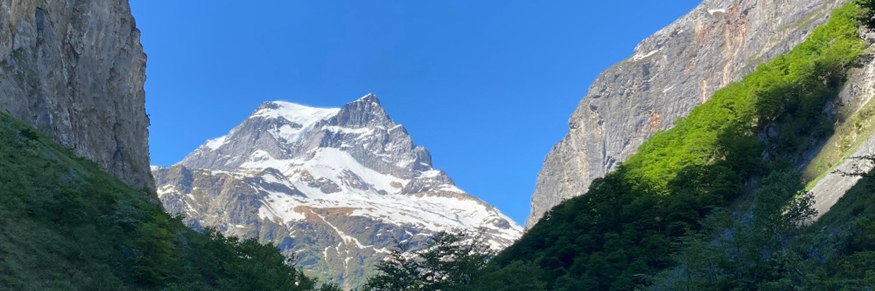
Southerly foehn across the Alps today, with localised gusts exceeding 80 km/h in the Haslital, Urner Reusstal, and Liechtenstein regions.
Temperatures are rising above 20°C in northern Grisons, the Sargans area, and also northwestern Switzerland.
Temperatures are rising above 20°C in northern Grisons, the Sargans area, and also northwestern Switzerland.


November 1, 2025 at 9:06 AM
Southerly foehn across the Alps today, with localised gusts exceeding 80 km/h in the Haslital, Urner Reusstal, and Liechtenstein regions.
Temperatures are rising above 20°C in northern Grisons, the Sargans area, and also northwestern Switzerland.
Temperatures are rising above 20°C in northern Grisons, the Sargans area, and also northwestern Switzerland.
The Eastern Swiss Alps received their first significant snowfall: Arosa recorded 32 cm of fresh snow, while the Säntis summit (2,502 m; WMO ID 06680) now reports a total snow depth of 64 cm.
The 96-year record shows a historical maximum of 165 cm.
The 96-year record shows a historical maximum of 165 cm.

October 28, 2025 at 9:40 AM
The Eastern Swiss Alps received their first significant snowfall: Arosa recorded 32 cm of fresh snow, while the Säntis summit (2,502 m; WMO ID 06680) now reports a total snow depth of 64 cm.
The 96-year record shows a historical maximum of 165 cm.
The 96-year record shows a historical maximum of 165 cm.
October 2025, ending Friday night ... probably globally the 3rd warmest (October 2025 and above all 2024 were warmer).
In Switzerland a bit colder than usual, exception Alps/south.
In Switzerland a bit colder than usual, exception Alps/south.

October 27, 2025 at 2:12 PM
October 2025, ending Friday night ... probably globally the 3rd warmest (October 2025 and above all 2024 were warmer).
In Switzerland a bit colder than usual, exception Alps/south.
In Switzerland a bit colder than usual, exception Alps/south.

Tropical Storm Melissa south of Jamaica is rapidly strengthening over very warm waters and low wind shear, likely reaching Category 5 by Monday.
With only slow movement, potentially catastrophic flooding threatens Jamaica, Haiti, and later the Bermuda region.
With only slow movement, potentially catastrophic flooding threatens Jamaica, Haiti, and later the Bermuda region.


October 25, 2025 at 4:46 PM
Tropical Storm Melissa south of Jamaica is rapidly strengthening over very warm waters and low wind shear, likely reaching Category 5 by Monday.
With only slow movement, potentially catastrophic flooding threatens Jamaica, Haiti, and later the Bermuda region.
With only slow movement, potentially catastrophic flooding threatens Jamaica, Haiti, and later the Bermuda region.
Eastern tropical Atlantic storm activity has ceased; focus shifts to the Caribbean, where SSTs remain elevated.
TD 98L may develop into Tropical Storm Melissa, but ensemble spread (ECMWF and google) indicates high uncertainty in its evolution!
TD 98L may develop into Tropical Storm Melissa, but ensemble spread (ECMWF and google) indicates high uncertainty in its evolution!

October 20, 2025 at 2:20 PM
Eastern tropical Atlantic storm activity has ceased; focus shifts to the Caribbean, where SSTs remain elevated.
TD 98L may develop into Tropical Storm Melissa, but ensemble spread (ECMWF and google) indicates high uncertainty in its evolution!
TD 98L may develop into Tropical Storm Melissa, but ensemble spread (ECMWF and google) indicates high uncertainty in its evolution!
Greenland Ice Sheet (GIS) experienced exceptionally low temperatures this morning: Summit Station (3,209 m a.s.l.) recorded a minimum of –46 °C!
A regionally anomaly - northern Canada, Greenland, and Siberia exhibit above-seasonal warmth.
A regionally anomaly - northern Canada, Greenland, and Siberia exhibit above-seasonal warmth.


October 20, 2025 at 10:03 AM
Greenland Ice Sheet (GIS) experienced exceptionally low temperatures this morning: Summit Station (3,209 m a.s.l.) recorded a minimum of –46 °C!
A regionally anomaly - northern Canada, Greenland, and Siberia exhibit above-seasonal warmth.
A regionally anomaly - northern Canada, Greenland, and Siberia exhibit above-seasonal warmth.
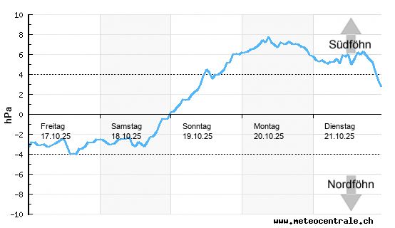
Switzerland’s detailed weather map for Monday AM:
Strong southwesterlies wind (coloured) in the Jura. Strong pressure gradient over the Alps (isobar spacing 1 hPa; two zones of enhanced gradient) driving vigorous southerly föhn winds. Hotspots: Haslital, Erstfeld vicinity, Balzers/FL, and Appenzell.
Strong southwesterlies wind (coloured) in the Jura. Strong pressure gradient over the Alps (isobar spacing 1 hPa; two zones of enhanced gradient) driving vigorous southerly föhn winds. Hotspots: Haslital, Erstfeld vicinity, Balzers/FL, and Appenzell.

October 20, 2025 at 7:40 AM
Switzerland’s detailed weather map for Monday AM:
Strong southwesterlies wind (coloured) in the Jura. Strong pressure gradient over the Alps (isobar spacing 1 hPa; two zones of enhanced gradient) driving vigorous southerly föhn winds. Hotspots: Haslital, Erstfeld vicinity, Balzers/FL, and Appenzell.
Strong southwesterlies wind (coloured) in the Jura. Strong pressure gradient over the Alps (isobar spacing 1 hPa; two zones of enhanced gradient) driving vigorous southerly föhn winds. Hotspots: Haslital, Erstfeld vicinity, Balzers/FL, and Appenzell.
Saturday noon: Sunshine returns to the Swiss lplateau. Low stratus in the east cleared not due to reduced bise but to dry air advection from Scandinavia (850 hPa air mass temperature).
A clear night into Sunday will bring cold conditions, with frost and hoar on grass and cars.
A clear night into Sunday will bring cold conditions, with frost and hoar on grass and cars.

October 18, 2025 at 11:12 AM
Saturday noon: Sunshine returns to the Swiss lplateau. Low stratus in the east cleared not due to reduced bise but to dry air advection from Scandinavia (850 hPa air mass temperature).
A clear night into Sunday will bring cold conditions, with frost and hoar on grass and cars.
A clear night into Sunday will bring cold conditions, with frost and hoar on grass and cars.
Autumn is not merely the season of fog—it is also a period of föhn.
The first föhn event of this October is now occurring: on Sunday, southerly winds over the Alps will intensify, with gusts reaching up to 80 km/h in typical valleys by Monday morning and midday, accompanied by highs of 18°C.
The first föhn event of this October is now occurring: on Sunday, southerly winds over the Alps will intensify, with gusts reaching up to 80 km/h in typical valleys by Monday morning and midday, accompanied by highs of 18°C.
October 17, 2025 at 3:45 PM
Autumn is not merely the season of fog—it is also a period of föhn.
The first föhn event of this October is now occurring: on Sunday, southerly winds over the Alps will intensify, with gusts reaching up to 80 km/h in typical valleys by Monday morning and midday, accompanied by highs of 18°C.
The first föhn event of this October is now occurring: on Sunday, southerly winds over the Alps will intensify, with gusts reaching up to 80 km/h in typical valleys by Monday morning and midday, accompanied by highs of 18°C.
Temperatur anomaly of October 2025 so far: +0.5° warmer than 1991-2020 reference.
Only (whole) October 2024 (+0.79) and October 2023 (+0.76 deg) were warmer.
Source: climatlas.com, based on JRA-55 reanalysis
Only (whole) October 2024 (+0.79) and October 2023 (+0.76 deg) were warmer.
Source: climatlas.com, based on JRA-55 reanalysis

October 17, 2025 at 2:05 PM
Temperatur anomaly of October 2025 so far: +0.5° warmer than 1991-2020 reference.
Only (whole) October 2024 (+0.79) and October 2023 (+0.76 deg) were warmer.
Source: climatlas.com, based on JRA-55 reanalysis
Only (whole) October 2024 (+0.79) and October 2023 (+0.76 deg) were warmer.
Source: climatlas.com, based on JRA-55 reanalysis
Latest SSTA data reveal persistently elevated Atlantic temperatures, alongside extreme warmth in the northern Pacific, Baltic, and Barents Seas.
However, a developing La Niña is evident in the eastern tropical Pacific, concurrent with a negative Indian Ocean Dipole (IOD).
However, a developing La Niña is evident in the eastern tropical Pacific, concurrent with a negative Indian Ocean Dipole (IOD).

October 15, 2025 at 9:25 AM
Latest SSTA data reveal persistently elevated Atlantic temperatures, alongside extreme warmth in the northern Pacific, Baltic, and Barents Seas.
However, a developing La Niña is evident in the eastern tropical Pacific, concurrent with a negative Indian Ocean Dipole (IOD).
However, a developing La Niña is evident in the eastern tropical Pacific, concurrent with a negative Indian Ocean Dipole (IOD).