


Gus
@gusbecker.bsky.social
Data Scientist | Zinemaker | Freelance Illustrator
Pinned
Gus
@gusbecker.bsky.social
· Aug 8
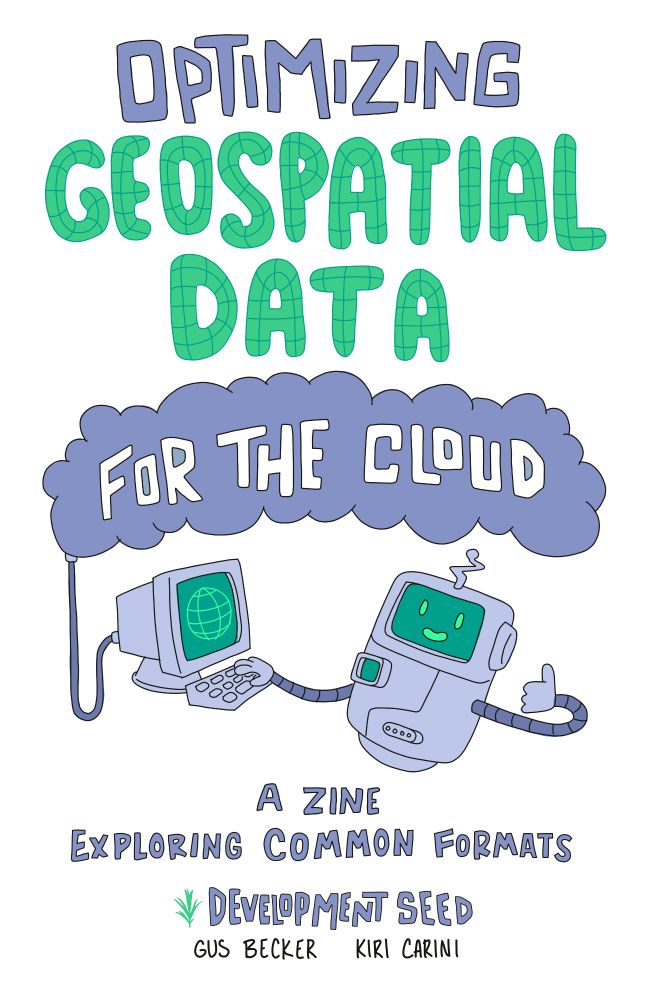
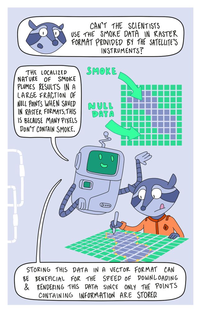
Zines are a great tool for science communication. Earlier this year, I put one together with @kiricarini.com of @developmentseed.org.
The zine provides a visually interesting jumping off point for folks learning cloud-native geospatial data!
The zine provides a visually interesting jumping off point for folks learning cloud-native geospatial data!
Reposted by Gus
A few years ago, I attended #virtualCCFest for the first time and left inspired! Today, I will be delivering the closing keynote at CC Fest. I'm looking forward to sharing my love of creative coding and encouraging others to archive (and share!) their creative work.


September 28, 2025 at 3:34 PM
A few years ago, I attended #virtualCCFest for the first time and left inspired! Today, I will be delivering the closing keynote at CC Fest. I'm looking forward to sharing my love of creative coding and encouraging others to archive (and share!) their creative work.
Reposted by Gus

#virtualCCFest is back on Sunday, Sept 28, with amazing keynotes and workshops on creative coding lined-up. You can see and details and RSVP at ccfest.rocks. If you donate your funds will go to support the costs of the free event, Zoom licenses and small stipends for presenters and keynotes.
September 2, 2025 at 10:46 PM
#virtualCCFest is back on Sunday, Sept 28, with amazing keynotes and workshops on creative coding lined-up. You can see and details and RSVP at ccfest.rocks. If you donate your funds will go to support the costs of the free event, Zoom licenses and small stipends for presenters and keynotes.
Reposted by Gus

One of my customers had so much fun visiting the Map Center that he came back a few days later with a camera. He made this magnificent short documentary about my store, about me, and why I bother to do any of it at all.
It's really lovely and I hope you watch it!
youtu.be/Dj9uKpk3Idk?...
It's really lovely and I hope you watch it!
youtu.be/Dj9uKpk3Idk?...
The Map Center
YouTube video by You Are Here
youtu.be
August 25, 2025 at 12:21 PM
One of my customers had so much fun visiting the Map Center that he came back a few days later with a camera. He made this magnificent short documentary about my store, about me, and why I bother to do any of it at all.
It's really lovely and I hope you watch it!
youtu.be/Dj9uKpk3Idk?...
It's really lovely and I hope you watch it!
youtu.be/Dj9uKpk3Idk?...
Reposted by Gus

You’re invited to join the next Jupyter Community Call on September 04, 2025! Get updates from across the Jupyter ecosystem, hear talks from community members, and learn how you can get involved. It’s a great way to connect, contribute, and stay in the loop. Learn more medium.com/@rosioreyes/...
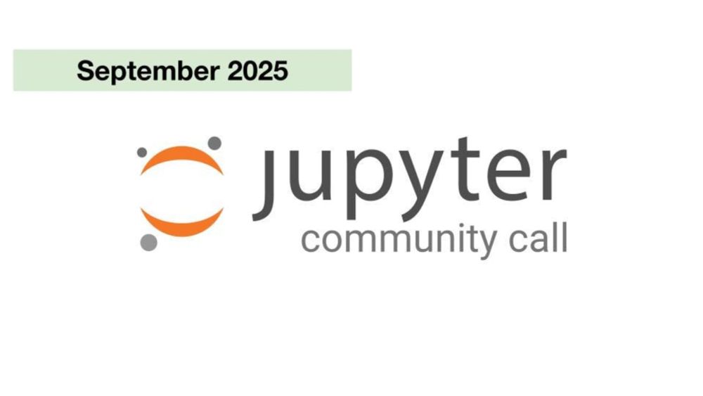
Jupyter Community Call: September 2025
Hey Jovyans, we want to learn about the great things you’re doing with Jupyter! The Community Building working group is holding an open…
medium.com
July 31, 2025 at 3:14 PM
You’re invited to join the next Jupyter Community Call on September 04, 2025! Get updates from across the Jupyter ecosystem, hear talks from community members, and learn how you can get involved. It’s a great way to connect, contribute, and stay in the loop. Learn more medium.com/@rosioreyes/...
Zines are a great tool for science communication. Earlier this year, I put one together with @kiricarini.com of @developmentseed.org.
The zine provides a visually interesting jumping off point for folks learning cloud-native geospatial data!
The zine provides a visually interesting jumping off point for folks learning cloud-native geospatial data!
August 8, 2025 at 2:42 PM
Zines are a great tool for science communication. Earlier this year, I put one together with @kiricarini.com of @developmentseed.org.
The zine provides a visually interesting jumping off point for folks learning cloud-native geospatial data!
The zine provides a visually interesting jumping off point for folks learning cloud-native geospatial data!
Reposted by Gus
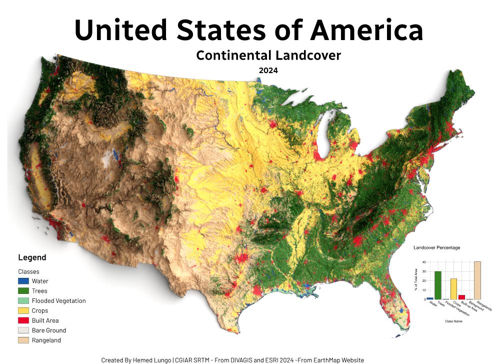
🗺️ USA Land Cover Map – 2024 🇺🇸
Made with QGIS & Blender using:
🌱 ESRI Land Cover (EarthMap)
🏔️ DEM from DivaGIS (CGIAR SRTM)
Forests, croplands, wetlands & cities — mapped to show the patterns shaping America's surface.
#USA #LandCover #QGIS #Blender #Cartography #GISChat #RemoteSensing #Map #OpenData
Made with QGIS & Blender using:
🌱 ESRI Land Cover (EarthMap)
🏔️ DEM from DivaGIS (CGIAR SRTM)
Forests, croplands, wetlands & cities — mapped to show the patterns shaping America's surface.
#USA #LandCover #QGIS #Blender #Cartography #GISChat #RemoteSensing #Map #OpenData
July 23, 2025 at 7:41 PM
🗺️ USA Land Cover Map – 2024 🇺🇸
Made with QGIS & Blender using:
🌱 ESRI Land Cover (EarthMap)
🏔️ DEM from DivaGIS (CGIAR SRTM)
Forests, croplands, wetlands & cities — mapped to show the patterns shaping America's surface.
#USA #LandCover #QGIS #Blender #Cartography #GISChat #RemoteSensing #Map #OpenData
Made with QGIS & Blender using:
🌱 ESRI Land Cover (EarthMap)
🏔️ DEM from DivaGIS (CGIAR SRTM)
Forests, croplands, wetlands & cities — mapped to show the patterns shaping America's surface.
#USA #LandCover #QGIS #Blender #Cartography #GISChat #RemoteSensing #Map #OpenData