


A Map🗺️ Showing Geology of Africa Continent , Dataset is from USGS and GEBCO Bathymetry #Africa #EastAfrica #WestAfrica #SouthAfrica #NorthAfrica #geology #map #dataviz #gischat #geospatial #dataviz #qgis #b3d #Blender

November 15, 2025 at 2:05 PM
A Map🗺️ Showing Geology of Africa Continent , Dataset is from USGS and GEBCO Bathymetry #Africa #EastAfrica #WestAfrica #SouthAfrica #NorthAfrica #geology #map #dataviz #gischat #geospatial #dataviz #qgis #b3d #Blender
A new bathymetry model of Lake Victoria 🌊🗺️
Remastered dataset from Harvard Dataverse — mapping the hidden depths spanning 🇹🇿 🇰🇪 🇺🇬
#LakeVictoria #Africa #GIS #Cartography #DataViz
Remastered dataset from Harvard Dataverse — mapping the hidden depths spanning 🇹🇿 🇰🇪 🇺🇬
#LakeVictoria #Africa #GIS #Cartography #DataViz

October 26, 2025 at 8:09 PM
A new bathymetry model of Lake Victoria 🌊🗺️
Remastered dataset from Harvard Dataverse — mapping the hidden depths spanning 🇹🇿 🇰🇪 🇺🇬
#LakeVictoria #Africa #GIS #Cartography #DataViz
Remastered dataset from Harvard Dataverse — mapping the hidden depths spanning 🇹🇿 🇰🇪 🇺🇬
#LakeVictoria #Africa #GIS #Cartography #DataViz
🗺️Map showing Amazon Basin Land Cover – 2024
Made with QGIS & Blender using:
🏞️Landcover Map from ESRI Landcover 2024
⛰️DEM from Elevatr Library in R programming #Amazon #SouthAmerica #QGIS #Blender #b3d #data #Cartography #GIS #gischat #LandCover #map
Made with QGIS & Blender using:
🏞️Landcover Map from ESRI Landcover 2024
⛰️DEM from Elevatr Library in R programming #Amazon #SouthAmerica #QGIS #Blender #b3d #data #Cartography #GIS #gischat #LandCover #map

October 26, 2025 at 3:59 PM
🗺️Map showing Amazon Basin Land Cover – 2024
Made with QGIS & Blender using:
🏞️Landcover Map from ESRI Landcover 2024
⛰️DEM from Elevatr Library in R programming #Amazon #SouthAmerica #QGIS #Blender #b3d #data #Cartography #GIS #gischat #LandCover #map
Made with QGIS & Blender using:
🏞️Landcover Map from ESRI Landcover 2024
⛰️DEM from Elevatr Library in R programming #Amazon #SouthAmerica #QGIS #Blender #b3d #data #Cartography #GIS #gischat #LandCover #map

🗺️Map showing Switzerland Land Cover – 2024🇨🇭
Made with QGIS & Blender using:
🏞️Landcover from EarthMap (ESRI 2024)
⛰️ DEM from Elevatr R
#Switzerland #Europe #QGIS #Blender #b3d #data #Cartography #GIS #gischat #LandCover #map
Made with QGIS & Blender using:
🏞️Landcover from EarthMap (ESRI 2024)
⛰️ DEM from Elevatr R
#Switzerland #Europe #QGIS #Blender #b3d #data #Cartography #GIS #gischat #LandCover #map

October 25, 2025 at 3:59 PM
🗺️Map showing Switzerland Land Cover – 2024🇨🇭
Made with QGIS & Blender using:
🏞️Landcover from EarthMap (ESRI 2024)
⛰️ DEM from Elevatr R
#Switzerland #Europe #QGIS #Blender #b3d #data #Cartography #GIS #gischat #LandCover #map
Made with QGIS & Blender using:
🏞️Landcover from EarthMap (ESRI 2024)
⛰️ DEM from Elevatr R
#Switzerland #Europe #QGIS #Blender #b3d #data #Cartography #GIS #gischat #LandCover #map

🗺️ Map showing Mexico Land Cover – 2024 🇲🇽
Made with QGIS & Blender using:
🏞️ Landcover from EarthMap (ESRI 2024)
⛰️ DEM from Divagis
#Mexico #CDMX #NorthAmerica #QGIS #Blender #b3d #data #Cartography #GIS #gischat #LandCover #map
Made with QGIS & Blender using:
🏞️ Landcover from EarthMap (ESRI 2024)
⛰️ DEM from Divagis
#Mexico #CDMX #NorthAmerica #QGIS #Blender #b3d #data #Cartography #GIS #gischat #LandCover #map

October 23, 2025 at 3:02 PM
🗺️ Map showing Mexico Land Cover – 2024 🇲🇽
Made with QGIS & Blender using:
🏞️ Landcover from EarthMap (ESRI 2024)
⛰️ DEM from Divagis
#Mexico #CDMX #NorthAmerica #QGIS #Blender #b3d #data #Cartography #GIS #gischat #LandCover #map
Made with QGIS & Blender using:
🏞️ Landcover from EarthMap (ESRI 2024)
⛰️ DEM from Divagis
#Mexico #CDMX #NorthAmerica #QGIS #Blender #b3d #data #Cartography #GIS #gischat #LandCover #map
Reposted by Hemed

Geohipster Calendar - Submissions extended unto 10/23/2025 - Submit a map and and keep the longest running geo calendar going! www.geohipster.com/2025/07/30/2... #qgis #esri #foss4g #arcpro

2026 Calendar Submissions - GeoHipster
Submit a calendar for the 2026 calendar year by october. Fame and Fortune (there is no fortune) await.
www.geohipster.com
October 16, 2025 at 4:09 PM
Geohipster Calendar - Submissions extended unto 10/23/2025 - Submit a map and and keep the longest running geo calendar going! www.geohipster.com/2025/07/30/2... #qgis #esri #foss4g #arcpro
🗺️Map showing Uganda Land Cover – 2024
Made with QGIS & Blender using:
🏞️Landcover from EarthMap (ESRI 2024)
⛰️DEM from Divagis
#Uganda #EastAfrica #Africa #QGIS #Blender #b3d #data #Cartography #gischat #LandCover #map
Made with QGIS & Blender using:
🏞️Landcover from EarthMap (ESRI 2024)
⛰️DEM from Divagis
#Uganda #EastAfrica #Africa #QGIS #Blender #b3d #data #Cartography #gischat #LandCover #map

October 14, 2025 at 4:39 PM
🗺️Map showing Uganda Land Cover – 2024
Made with QGIS & Blender using:
🏞️Landcover from EarthMap (ESRI 2024)
⛰️DEM from Divagis
#Uganda #EastAfrica #Africa #QGIS #Blender #b3d #data #Cartography #gischat #LandCover #map
Made with QGIS & Blender using:
🏞️Landcover from EarthMap (ESRI 2024)
⛰️DEM from Divagis
#Uganda #EastAfrica #Africa #QGIS #Blender #b3d #data #Cartography #gischat #LandCover #map
Reposted by Hemed

Update on QGIS 4.0 Release Schedule and LTR Plans
Following the earlier announcement that QGIS is moving to Qt 6 and launching QGIS 4.0, we want to share an important update about the QGIS 4.x roadmap. After extensive discussion on the developer mailing list, the QGIS community has agreed to […]
Following the earlier announcement that QGIS is moving to Qt 6 and launching QGIS 4.0, we want to share an important update about the QGIS 4.x roadmap. After extensive discussion on the developer mailing list, the QGIS community has agreed to […]
Original post on fosstodon.org
fosstodon.org
October 7, 2025 at 9:25 PM
Update on QGIS 4.0 Release Schedule and LTR Plans
Following the earlier announcement that QGIS is moving to Qt 6 and launching QGIS 4.0, we want to share an important update about the QGIS 4.x roadmap. After extensive discussion on the developer mailing list, the QGIS community has agreed to […]
Following the earlier announcement that QGIS is moving to Qt 6 and launching QGIS 4.0, we want to share an important update about the QGIS 4.x roadmap. After extensive discussion on the developer mailing list, the QGIS community has agreed to […]
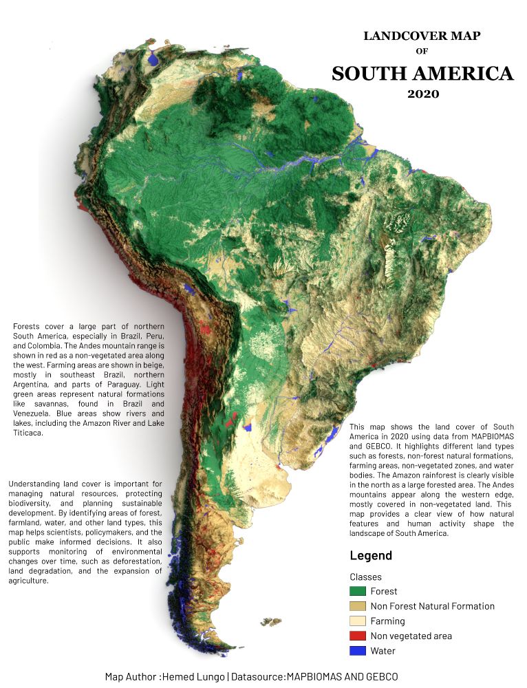
🌎 South America Landcover Map 2024 🌳🏜️
From the Amazon rainforest (a vital carbon sink) to the Atacama Desert, this map shows how nature & human activity shape the continent:
#SouthAmerica #Landcover #qgis #b3d #blender #gischat
From the Amazon rainforest (a vital carbon sink) to the Atacama Desert, this map shows how nature & human activity shape the continent:
#SouthAmerica #Landcover #qgis #b3d #blender #gischat

September 26, 2025 at 5:34 PM
🌎 South America Landcover Map 2024 🌳🏜️
From the Amazon rainforest (a vital carbon sink) to the Atacama Desert, this map shows how nature & human activity shape the continent:
#SouthAmerica #Landcover #qgis #b3d #blender #gischat
From the Amazon rainforest (a vital carbon sink) to the Atacama Desert, this map shows how nature & human activity shape the continent:
#SouthAmerica #Landcover #qgis #b3d #blender #gischat
Reposted by Hemed

Add a new field to an attribute table in #QGIS

Add a new field to attribute table in QGIS | burdGIS
Editing mode in QGIS can be really useful. Here we look at how to add a new field to an attribute table, fill in some values and style our layer thematically with the new values. To do this we use…
youtu.be
September 24, 2025 at 8:34 AM
Add a new field to an attribute table in #QGIS
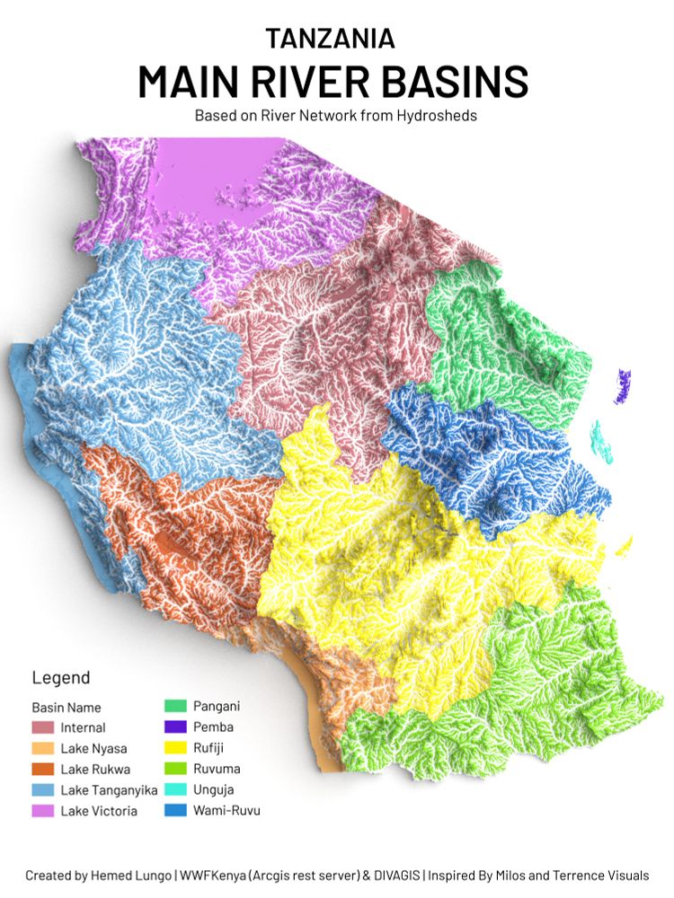
🗺️ Map showing Tanzania – Potential Natural Vegetation 🌍
Made with QGIS & Blender using:
🌱 Vegetationmap4Africa (EcoDiv.earth)
🏔️ DIVA-GIS DEM Data
Credit: @ecodiv.bsky.social
#Tanzania #VegetationMap #QGIS #Blender #Cartography #OpenData #Biodiversity #EcodivEarth #FOSS4G
Made with QGIS & Blender using:
🌱 Vegetationmap4Africa (EcoDiv.earth)
🏔️ DIVA-GIS DEM Data
Credit: @ecodiv.bsky.social
#Tanzania #VegetationMap #QGIS #Blender #Cartography #OpenData #Biodiversity #EcodivEarth #FOSS4G

September 5, 2025 at 5:42 PM
🗺️ Map showing Tanzania – Potential Natural Vegetation 🌍
Made with QGIS & Blender using:
🌱 Vegetationmap4Africa (EcoDiv.earth)
🏔️ DIVA-GIS DEM Data
Credit: @ecodiv.bsky.social
#Tanzania #VegetationMap #QGIS #Blender #Cartography #OpenData #Biodiversity #EcodivEarth #FOSS4G
Made with QGIS & Blender using:
🌱 Vegetationmap4Africa (EcoDiv.earth)
🏔️ DIVA-GIS DEM Data
Credit: @ecodiv.bsky.social
#Tanzania #VegetationMap #QGIS #Blender #Cartography #OpenData #Biodiversity #EcodivEarth #FOSS4G
Reposted by Hemed

I’ve been working on a QGIS plug-in to pull GBIF observations into user selected areas of interest. It’s still a WIP, but check it out! All thanks to the GBIF API
github.com/aidanwobrien...
github.com/aidanwobrien...

GitHub - aidanwobrien/QGIS-GBIF-Polygon-Services: Using the GBIF API, this plugins allows the user to query all the species occurrence records within a specified polygon layer
Using the GBIF API, this plugins allows the user to query all the species occurrence records within a specified polygon layer - aidanwobrien/QGIS-GBIF-Polygon-Services
github.com
September 1, 2025 at 12:33 PM
I’ve been working on a QGIS plug-in to pull GBIF observations into user selected areas of interest. It’s still a WIP, but check it out! All thanks to the GBIF API
github.com/aidanwobrien...
github.com/aidanwobrien...
🗺️ Map showing Africa Land Cover – 2024 🌍 Made with QGIS & Blender using:
🌱 ESRI Land Cover Data
🏔️ GEBCO DEM Data
#Africa #LandCover #QGIS #Blender #gischat #Map #Cartography
🌱 ESRI Land Cover Data
🏔️ GEBCO DEM Data
#Africa #LandCover #QGIS #Blender #gischat #Map #Cartography

August 31, 2025 at 6:16 PM
🗺️ Map showing Africa Land Cover – 2024 🌍 Made with QGIS & Blender using:
🌱 ESRI Land Cover Data
🏔️ GEBCO DEM Data
#Africa #LandCover #QGIS #Blender #gischat #Map #Cartography
🌱 ESRI Land Cover Data
🏔️ GEBCO DEM Data
#Africa #LandCover #QGIS #Blender #gischat #Map #Cartography
Reposted by Hemed

It's a plugin for QGIS that allows you to store geographic locations in your Zotero citation metadata and lets you make maps of your the papers you put in Zotero.
Docs: micheletobias.github.io/maps/Literat...
GitHub: github.com/MicheleTobia...
Proof-of-Concept: journals.sagepub.com/doi/full/10....
Docs: micheletobias.github.io/maps/Literat...
GitHub: github.com/MicheleTobia...
Proof-of-Concept: journals.sagepub.com/doi/full/10....
Maps by MicheleTobias
micheletobias.github.io
August 28, 2025 at 9:29 PM
It's a plugin for QGIS that allows you to store geographic locations in your Zotero citation metadata and lets you make maps of your the papers you put in Zotero.
Docs: micheletobias.github.io/maps/Literat...
GitHub: github.com/MicheleTobia...
Proof-of-Concept: journals.sagepub.com/doi/full/10....
Docs: micheletobias.github.io/maps/Literat...
GitHub: github.com/MicheleTobia...
Proof-of-Concept: journals.sagepub.com/doi/full/10....
Reposted by Hemed

So for the past month (or so) i have been designing a map based on various places that I have traveled to in Colorado in 2025. I am not currently looking for feedback ( that will come) I just want to relish in the enjoyment of having completed a map in QGIS and Adobe Illustrator #GISChat #MapSky

August 21, 2025 at 2:16 PM
Reposted by Hemed

I'd personally suggest ESRI's MOOCs (www.esri.com/training/mooc). I know, weird choice right? But, I found the knowledge I gained there transferable to how I used QGIS.
Alternatively, I'd have to refer to QGIS training manual and tutorials:
docs.qgis.org/3.40/en/docs...
www.qgistutorials.com/en
Alternatively, I'd have to refer to QGIS training manual and tutorials:
docs.qgis.org/3.40/en/docs...
www.qgistutorials.com/en
QGIS Training Manual — QGIS Documentation documentation
QGIS 3.40 documentation: QGIS Training Manual
docs.qgis.org
August 22, 2025 at 6:37 PM
I'd personally suggest ESRI's MOOCs (www.esri.com/training/mooc). I know, weird choice right? But, I found the knowledge I gained there transferable to how I used QGIS.
Alternatively, I'd have to refer to QGIS training manual and tutorials:
docs.qgis.org/3.40/en/docs...
www.qgistutorials.com/en
Alternatively, I'd have to refer to QGIS training manual and tutorials:
docs.qgis.org/3.40/en/docs...
www.qgistutorials.com/en
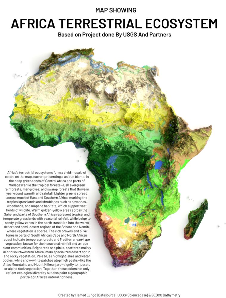
A Map🗺️ Showing Terrestrial Ecosystem of Africa Continent , Dataset is from USGS (ScienceBase) #Africa #EastAfrica #WestAfrica #SouthAfrica #NorthAfrica #Soil #Soiltype #geology #map #dataviz #gischat #geospatial #dataviz #qgis #b3d #Blender #USGS
August 9, 2025 at 6:09 PM
A Map🗺️ Showing Terrestrial Ecosystem of Africa Continent , Dataset is from USGS (ScienceBase) #Africa #EastAfrica #WestAfrica #SouthAfrica #NorthAfrica #Soil #Soiltype #geology #map #dataviz #gischat #geospatial #dataviz #qgis #b3d #Blender #USGS
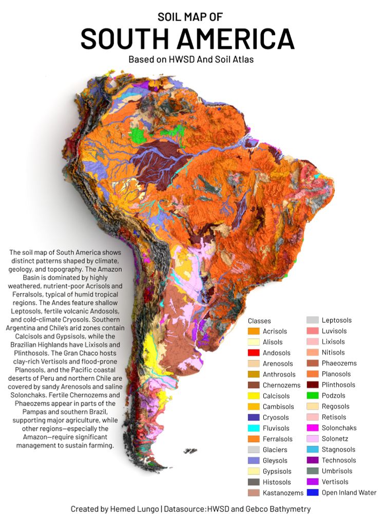
A Map🗺️Showing Soil Types of South America Continent , Dataset is from HWSD and GEBCO Bathymetry #SouthAmerica #LatinAmerica #Soil #Soiltype #geology #map #dataviz #gischat #geospatial #dataviz #qgis #b3d #Blender
August 8, 2025 at 4:40 PM
A Map🗺️Showing Soil Types of South America Continent , Dataset is from HWSD and GEBCO Bathymetry #SouthAmerica #LatinAmerica #Soil #Soiltype #geology #map #dataviz #gischat #geospatial #dataviz #qgis #b3d #Blender
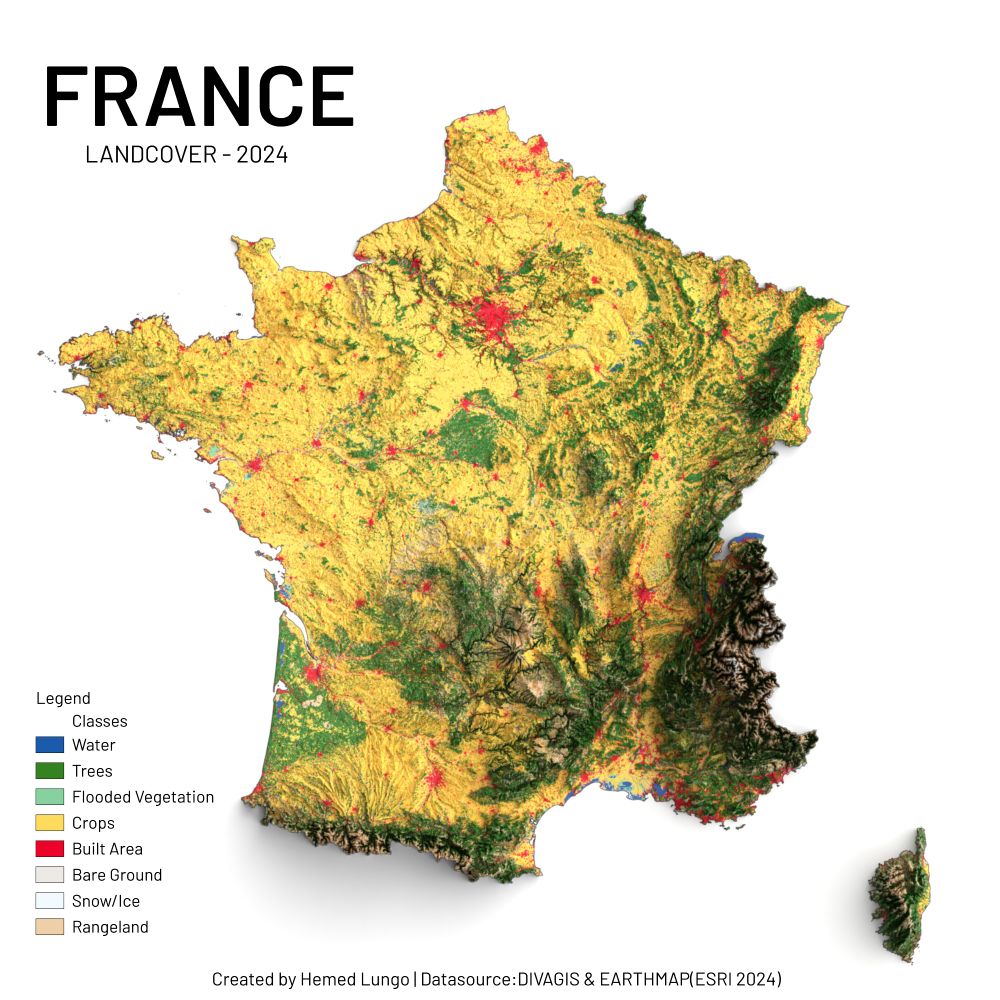
🗺️ France Landcover – 2024 🇫🇷
Réalisée avec QGIS & Blender à l’aide de :
🌱 ESRI Land Cover (2024)
🏔️ DEM de DivaGIS
Un aperçu éclatant des paysages français : forêts, cultures, montagnes, rivières et zones urbaines en expansion.
#France #Europe #QGIS #Blender #data #gischat #map
Réalisée avec QGIS & Blender à l’aide de :
🌱 ESRI Land Cover (2024)
🏔️ DEM de DivaGIS
Un aperçu éclatant des paysages français : forêts, cultures, montagnes, rivières et zones urbaines en expansion.
#France #Europe #QGIS #Blender #data #gischat #map
August 7, 2025 at 7:37 PM
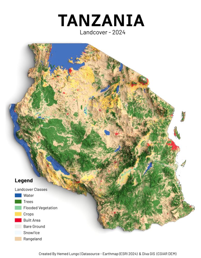
🗺️Tanzania Landcover – 2024🇹🇿
Made with QGIS & Blender using:
🌱 ESRI Land Cover Data (2024)
🏔️ DEM from DivaGIS
A vivid look at Tanzania’s diverse landscapes: from lush forests and croplands to shimmering lakes and growing urban zones. #Tanzania #Africa #QGIS #Blender #gischat
Made with QGIS & Blender using:
🌱 ESRI Land Cover Data (2024)
🏔️ DEM from DivaGIS
A vivid look at Tanzania’s diverse landscapes: from lush forests and croplands to shimmering lakes and growing urban zones. #Tanzania #Africa #QGIS #Blender #gischat
August 2, 2025 at 11:17 PM
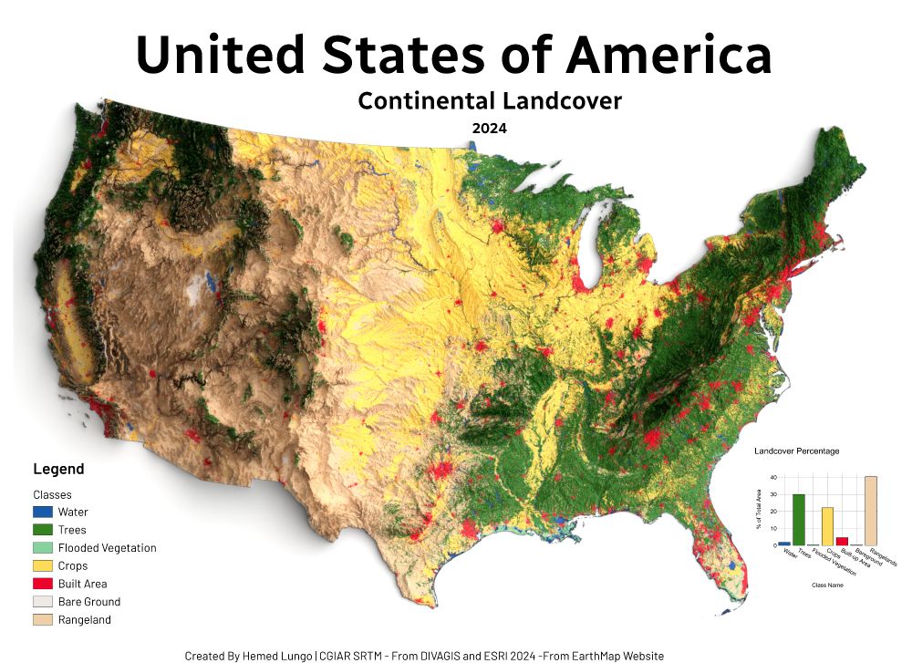
🗺️ USA Land Cover Map – 2024 🇺🇸
Made with QGIS & Blender using:
🌱 ESRI Land Cover (EarthMap)
🏔️ DEM from DivaGIS (CGIAR SRTM)
Forests, croplands, wetlands & cities — mapped to show the patterns shaping America's surface.
#USA #LandCover #QGIS #Blender #Cartography #GISChat #RemoteSensing #Map #OpenData
Made with QGIS & Blender using:
🌱 ESRI Land Cover (EarthMap)
🏔️ DEM from DivaGIS (CGIAR SRTM)
Forests, croplands, wetlands & cities — mapped to show the patterns shaping America's surface.
#USA #LandCover #QGIS #Blender #Cartography #GISChat #RemoteSensing #Map #OpenData
July 23, 2025 at 7:41 PM
🗺️ USA Land Cover Map – 2024 🇺🇸
Made with QGIS & Blender using:
🌱 ESRI Land Cover (EarthMap)
🏔️ DEM from DivaGIS (CGIAR SRTM)
Forests, croplands, wetlands & cities — mapped to show the patterns shaping America's surface.
#USA #LandCover #QGIS #Blender #Cartography #GISChat #RemoteSensing #Map #OpenData
Made with QGIS & Blender using:
🌱 ESRI Land Cover (EarthMap)
🏔️ DEM from DivaGIS (CGIAR SRTM)
Forests, croplands, wetlands & cities — mapped to show the patterns shaping America's surface.
#USA #LandCover #QGIS #Blender #Cartography #GISChat #RemoteSensing #Map #OpenData
🗺️ Map showing Land Cover of South America (2020)
From the vast Amazon 🌳 to the Andes 🏔️ and farmlands 🌾 — this map reveals how land is used across the continent.
📊 Data:
@mapbiomas
@gebcobathymetry
#GIS #GEBCO #QGIS #Blender #gischat #Cartography #OpenData #SouthAmerica
From the vast Amazon 🌳 to the Andes 🏔️ and farmlands 🌾 — this map reveals how land is used across the continent.
📊 Data:
@mapbiomas
@gebcobathymetry
#GIS #GEBCO #QGIS #Blender #gischat #Cartography #OpenData #SouthAmerica
July 19, 2025 at 3:15 PM
🗺️ Map showing Land Cover of South America (2020)
From the vast Amazon 🌳 to the Andes 🏔️ and farmlands 🌾 — this map reveals how land is used across the continent.
📊 Data:
@mapbiomas
@gebcobathymetry
#GIS #GEBCO #QGIS #Blender #gischat #Cartography #OpenData #SouthAmerica
From the vast Amazon 🌳 to the Andes 🏔️ and farmlands 🌾 — this map reveals how land is used across the continent.
📊 Data:
@mapbiomas
@gebcobathymetry
#GIS #GEBCO #QGIS #Blender #gischat #Cartography #OpenData #SouthAmerica