


emazaola.bsky.social
@emazaola.bsky.social
#30DayMapChallenge Day 20: Water
Arrieta. #Sopela. Learning #bathymetry. After calculating the #Stumpf ratio using #Sentinel2 images, we compared it with the bathymetry layers (1 & 5 m) available at #GeoEuskadi.
A lot to process, a lot more to learn
#rstats #RemoteSensing #GIS #EarthObservation
Arrieta. #Sopela. Learning #bathymetry. After calculating the #Stumpf ratio using #Sentinel2 images, we compared it with the bathymetry layers (1 & 5 m) available at #GeoEuskadi.
A lot to process, a lot more to learn
#rstats #RemoteSensing #GIS #EarthObservation

November 20, 2025 at 12:47 PM
#30DayMapChallenge Day 20: Water
Arrieta. #Sopela. Learning #bathymetry. After calculating the #Stumpf ratio using #Sentinel2 images, we compared it with the bathymetry layers (1 & 5 m) available at #GeoEuskadi.
A lot to process, a lot more to learn
#rstats #RemoteSensing #GIS #EarthObservation
Arrieta. #Sopela. Learning #bathymetry. After calculating the #Stumpf ratio using #Sentinel2 images, we compared it with the bathymetry layers (1 & 5 m) available at #GeoEuskadi.
A lot to process, a lot more to learn
#rstats #RemoteSensing #GIS #EarthObservation
Reposted by emazaola.bsky.social

Last chance to turn it off.
On Monday, November 3rd, Microsoft will start using your LinkedIn data for AI training. And remember, you're opted in by default.
To toggle it off 👉 Account - Settings & Privacy > Data privacy > Data for Generative AI Improvement.
On Monday, November 3rd, Microsoft will start using your LinkedIn data for AI training. And remember, you're opted in by default.
To toggle it off 👉 Account - Settings & Privacy > Data privacy > Data for Generative AI Improvement.

October 31, 2025 at 1:37 PM
Last chance to turn it off.
On Monday, November 3rd, Microsoft will start using your LinkedIn data for AI training. And remember, you're opted in by default.
To toggle it off 👉 Account - Settings & Privacy > Data privacy > Data for Generative AI Improvement.
On Monday, November 3rd, Microsoft will start using your LinkedIn data for AI training. And remember, you're opted in by default.
To toggle it off 👉 Account - Settings & Privacy > Data privacy > Data for Generative AI Improvement.
Reposted by emazaola.bsky.social

🌍Exploring Sentinel-2 with the Copernicus Data Space Ecosystem (CDSE)?
Hugh Graham’s guide with vrtility in #rstats. Includes authentication & query of imagery and building cloud-free composites.
permian-global-research.github.io/vrtility/art...
#RSpatial #RemoteSensing #EarthObservation #GIS
Hugh Graham’s guide with vrtility in #rstats. Includes authentication & query of imagery and building cloud-free composites.
permian-global-research.github.io/vrtility/art...
#RSpatial #RemoteSensing #EarthObservation #GIS


September 24, 2025 at 1:03 PM
🌍Exploring Sentinel-2 with the Copernicus Data Space Ecosystem (CDSE)?
Hugh Graham’s guide with vrtility in #rstats. Includes authentication & query of imagery and building cloud-free composites.
permian-global-research.github.io/vrtility/art...
#RSpatial #RemoteSensing #EarthObservation #GIS
Hugh Graham’s guide with vrtility in #rstats. Includes authentication & query of imagery and building cloud-free composites.
permian-global-research.github.io/vrtility/art...
#RSpatial #RemoteSensing #EarthObservation #GIS
Reposted by emazaola.bsky.social

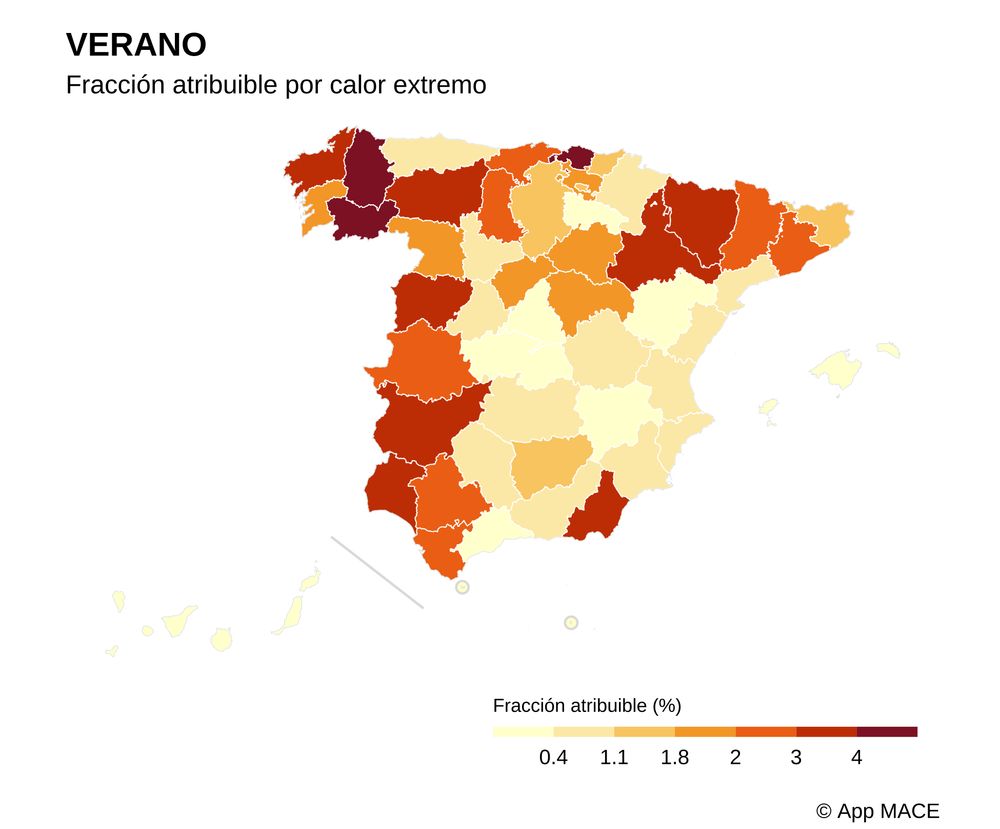
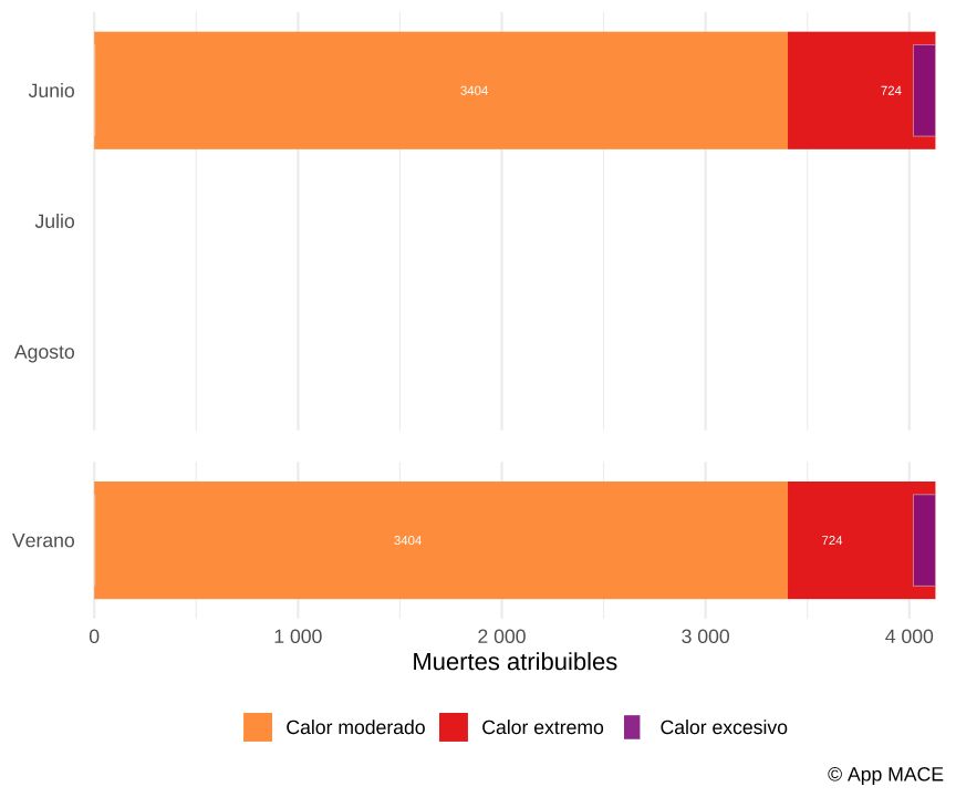
4128 muertes atribuibles al calor 🌡️ en JUNIO para toda España según nuestra aplicación #MACE. 3.404 por calor moderado y 724 por calor extremo. #oladecalor
En comparación junio de 2022 fueron 2859 y 879, respectivamente 🥵
@csic.es @mbgcsic.bsky.social
🔗https://ficlima.shinyapps.io/mace/
En comparación junio de 2022 fueron 2859 y 879, respectivamente 🥵
@csic.es @mbgcsic.bsky.social
🔗https://ficlima.shinyapps.io/mace/

July 4, 2025 at 8:11 AM
4128 muertes atribuibles al calor 🌡️ en JUNIO para toda España según nuestra aplicación #MACE. 3.404 por calor moderado y 724 por calor extremo. #oladecalor
En comparación junio de 2022 fueron 2859 y 879, respectivamente 🥵
@csic.es @mbgcsic.bsky.social
🔗https://ficlima.shinyapps.io/mace/
En comparación junio de 2022 fueron 2859 y 879, respectivamente 🥵
@csic.es @mbgcsic.bsky.social
🔗https://ficlima.shinyapps.io/mace/
Amplifying Climate Conversations: Urban Heat Islands in Txorierri
Aikor! published an insightful article on urban heat islands in Txorierri with a map made by hashtag #Gisarte. This is exactly the kind of localized, impactful climate reporting we need more of.
#rstats #RemoteSensing #GIS
Aikor! published an insightful article on urban heat islands in Txorierri with a map made by hashtag #Gisarte. This is exactly the kind of localized, impactful climate reporting we need more of.
#rstats #RemoteSensing #GIS

July 2, 2025 at 8:56 AM
Amplifying Climate Conversations: Urban Heat Islands in Txorierri
Aikor! published an insightful article on urban heat islands in Txorierri with a map made by hashtag #Gisarte. This is exactly the kind of localized, impactful climate reporting we need more of.
#rstats #RemoteSensing #GIS
Aikor! published an insightful article on urban heat islands in Txorierri with a map made by hashtag #Gisarte. This is exactly the kind of localized, impactful climate reporting we need more of.
#rstats #RemoteSensing #GIS
Reposted by emazaola.bsky.social
🧵1/
Informe de ventas de coches eléctricos en España
JUNIO 2025
Mes de récords que han roto cualquier pronóstico
Todos los detalles en el 🧵👇
Informe de ventas de coches eléctricos en España
JUNIO 2025
Mes de récords que han roto cualquier pronóstico
Todos los detalles en el 🧵👇

July 1, 2025 at 7:58 AM
🧵1/
Informe de ventas de coches eléctricos en España
JUNIO 2025
Mes de récords que han roto cualquier pronóstico
Todos los detalles en el 🧵👇
Informe de ventas de coches eléctricos en España
JUNIO 2025
Mes de récords que han roto cualquier pronóstico
Todos los detalles en el 🧵👇
Reposted by emazaola.bsky.social

My "Introduction to GIS Programming" book has been translated into Spanish
Grab your copy here: leanpub.com/gispro-es
What’s Included:
All code examples are freely available.
Access to 26 hours of free video tutorials to complement your learning.
Grab your copy here: leanpub.com/gispro-es
What’s Included:
All code examples are freely available.
Access to 26 hours of free video tutorials to complement your learning.

June 28, 2025 at 2:05 PM
My "Introduction to GIS Programming" book has been translated into Spanish
Grab your copy here: leanpub.com/gispro-es
What’s Included:
All code examples are freely available.
Access to 26 hours of free video tutorials to complement your learning.
Grab your copy here: leanpub.com/gispro-es
What’s Included:
All code examples are freely available.
Access to 26 hours of free video tutorials to complement your learning.
Reposted by emazaola.bsky.social

Sicily is so hot that the region has just issued an ordinance to suspend various types of agricultural and construction activities on hot days to avoid accidents at work. Essentially these activities will be off at 12:30-16:00pm until 31/8.
But let’s talk again how expensive climate mitigation is..
But let’s talk again how expensive climate mitigation is..

June 26, 2025 at 2:39 PM
Sicily is so hot that the region has just issued an ordinance to suspend various types of agricultural and construction activities on hot days to avoid accidents at work. Essentially these activities will be off at 12:30-16:00pm until 31/8.
But let’s talk again how expensive climate mitigation is..
But let’s talk again how expensive climate mitigation is..
Reposted by emazaola.bsky.social

Hego Euskal Herriko biztanle guztiek aire kaltegarria arnasten dute, Ekologistak Martxan-en arabera. Airearen kalitatea neurtzeko gailu guztiek gainditu dituzte Osasunaren Mundu Erakundeak gomendatutako kopuruak.
www.berria.eus/euska...
www.berria.eus/euska...

Hego Euskal Herriko biztanle guztiek aire kaltegarria arnasten dute, Ekologistak Martxan-en arabera
Airearen kalitatea neurtzeko gailu guztiek gainditu dituzte Osasunaren Mundu Erakundeak gomendatutako kopuruak. Aire kutsadura «nabarmen» murriztu da 2012-2019 aldiarekiko.
www.berria.eus
June 23, 2025 at 12:15 PM
Hego Euskal Herriko biztanle guztiek aire kaltegarria arnasten dute, Ekologistak Martxan-en arabera. Airearen kalitatea neurtzeko gailu guztiek gainditu dituzte Osasunaren Mundu Erakundeak gomendatutako kopuruak.
www.berria.eus/euska...
www.berria.eus/euska...
Reposted by emazaola.bsky.social

Josu Jon Imaz ha hecho bien su trabajo en el País Vasco. Viajar en coche eléctrico por aquí es como haber retrocedido 4 años en el tiempo. Hay muy pocos cargadores.
Hacía mucho tiempo que no planificaba. Hoy tendré que planificar.
Hacía mucho tiempo que no planificaba. Hoy tendré que planificar.
June 23, 2025 at 7:11 AM
Josu Jon Imaz ha hecho bien su trabajo en el País Vasco. Viajar en coche eléctrico por aquí es como haber retrocedido 4 años en el tiempo. Hay muy pocos cargadores.
Hacía mucho tiempo que no planificaba. Hoy tendré que planificar.
Hacía mucho tiempo que no planificaba. Hoy tendré que planificar.
Unlocking land insights with Sentinel-2 indexes to show vegetation health, water dynamics and drought stress
Pozuelo de Alarcón (Summer 2023) shows how combining NDVI+SAVI+NDMI reveals hidden patterns in urban greenspaces & water resources
#RemoteSensing #GIS #Environment #SmartCities #rstats
Pozuelo de Alarcón (Summer 2023) shows how combining NDVI+SAVI+NDMI reveals hidden patterns in urban greenspaces & water resources
#RemoteSensing #GIS #Environment #SmartCities #rstats


June 19, 2025 at 10:27 AM
Unlocking land insights with Sentinel-2 indexes to show vegetation health, water dynamics and drought stress
Pozuelo de Alarcón (Summer 2023) shows how combining NDVI+SAVI+NDMI reveals hidden patterns in urban greenspaces & water resources
#RemoteSensing #GIS #Environment #SmartCities #rstats
Pozuelo de Alarcón (Summer 2023) shows how combining NDVI+SAVI+NDMI reveals hidden patterns in urban greenspaces & water resources
#RemoteSensing #GIS #Environment #SmartCities #rstats
This afternoon we are going to talk in #Basauri about urban heat islands, climate shelters, and the impact of high temperatures on the health of children, the elderly, and pregnant women. And, of course, how #RemoteSensing and #GIS can help us address these climate challenges.
#rstats #UHI
#rstats #UHI

June 5, 2025 at 10:16 AM
This afternoon we are going to talk in #Basauri about urban heat islands, climate shelters, and the impact of high temperatures on the health of children, the elderly, and pregnant women. And, of course, how #RemoteSensing and #GIS can help us address these climate challenges.
#rstats #UHI
#rstats #UHI
Early this year, we worked with #Sagarrak for their citizen science project, measuring NO2 levels in schools across several Bizkaia municipalities. We struggled to define the buffer areas. We even built a Shinyapp so users could set their own boundaries. #datascience #GISChat #RStats #airpollution
June 3, 2025 at 10:48 AM
Early this year, we worked with #Sagarrak for their citizen science project, measuring NO2 levels in schools across several Bizkaia municipalities. We struggled to define the buffer areas. We even built a Shinyapp so users could set their own boundaries. #datascience #GISChat #RStats #airpollution
Mapping and GIS: requests can be wild! Before diving in, always define your needs, data, possibilities, purpose, visualization style, and scope. We tackled this last week with #FundacionAnesvad.
#datascience #rstats #GISChat #RStats
#datascience #rstats #GISChat #RStats

June 2, 2025 at 11:48 AM
Mapping and GIS: requests can be wild! Before diving in, always define your needs, data, possibilities, purpose, visualization style, and scope. We tackled this last week with #FundacionAnesvad.
#datascience #rstats #GISChat #RStats
#datascience #rstats #GISChat #RStats
Reposted by emazaola.bsky.social

🇫🇷 𝗠𝗔𝗣𝗣𝗜𝗡𝗚 𝗛𝗘𝗔𝗧 & 𝗣𝗢𝗣𝗨𝗟𝗔𝗧𝗜𝗢𝗡 🌡️👥
With summer heatwaves intensifying, I overlaid #MODIS LST and #GHSL 2030 population to spot where heat and people collide
#ClimateAction #UrbanResilience #GIS #HeatIslands #Sustainability
With summer heatwaves intensifying, I overlaid #MODIS LST and #GHSL 2030 population to spot where heat and people collide
#ClimateAction #UrbanResilience #GIS #HeatIslands #Sustainability

April 23, 2025 at 5:01 PM
🇫🇷 𝗠𝗔𝗣𝗣𝗜𝗡𝗚 𝗛𝗘𝗔𝗧 & 𝗣𝗢𝗣𝗨𝗟𝗔𝗧𝗜𝗢𝗡 🌡️👥
With summer heatwaves intensifying, I overlaid #MODIS LST and #GHSL 2030 population to spot where heat and people collide
#ClimateAction #UrbanResilience #GIS #HeatIslands #Sustainability
With summer heatwaves intensifying, I overlaid #MODIS LST and #GHSL 2030 population to spot where heat and people collide
#ClimateAction #UrbanResilience #GIS #HeatIslands #Sustainability
Sí. Y además de en el deporte profesional, sería interesante analizarlo en el deporte escolar, tanto competición como ocio
Sí. el tema es interesante, y altamente relevante, lo que ya hemos visto en el mundial de Qatar
February 25, 2025 at 2:45 PM
Sí. Y además de en el deporte profesional, sería interesante analizarlo en el deporte escolar, tanto competición como ocio
Reposted by emazaola.bsky.social

Just wanted to thank all of your #rstats folks that have used and promoted my elevatr 📦(github.com/usepa/elevatr)! It is currently the fourth most starred USEPA repository on GitHub! I am humbled.
And stay tuned for some future updates!
And stay tuned for some future updates!

GitHub - USEPA/elevatr: An R package for accessing elevation data
An R package for accessing elevation data. Contribute to USEPA/elevatr development by creating an account on GitHub.
github.com
January 10, 2025 at 3:08 PM
Just wanted to thank all of your #rstats folks that have used and promoted my elevatr 📦(github.com/usepa/elevatr)! It is currently the fourth most starred USEPA repository on GitHub! I am humbled.
And stay tuned for some future updates!
And stay tuned for some future updates!
Reposted by emazaola.bsky.social

Countries with less land area than American parking lots.

January 10, 2025 at 5:37 PM
Countries with less land area than American parking lots.
Tremendo trabajo, aunque hay que actualizar algunas fuentes:

January 7, 2025 at 9:14 AM
Tremendo trabajo, aunque hay que actualizar algunas fuentes:
Reposted by emazaola.bsky.social

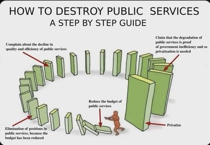
Not sure of the original source of this, but the depiction with the final domino set to crush the pusher is devastatingly accurate.
December 28, 2024 at 6:11 PM
Not sure of the original source of this, but the depiction with the final domino set to crush the pusher is devastatingly accurate.
Reposted by emazaola.bsky.social

🚀 #rstats #spanishoddata is now featured on the Ministerio de Transportes y Movilidad Sostenible's website as one of the alternative ways to access the open human mobility data for Spain: www.transportes.gob.es/ministerio/p...
#gischat
#spanishoddata home is here: ropenspain.github.io/spanishoddata/
#gischat
#spanishoddata home is here: ropenspain.github.io/spanishoddata/

December 26, 2024 at 5:10 PM
🚀 #rstats #spanishoddata is now featured on the Ministerio de Transportes y Movilidad Sostenible's website as one of the alternative ways to access the open human mobility data for Spain: www.transportes.gob.es/ministerio/p...
#gischat
#spanishoddata home is here: ropenspain.github.io/spanishoddata/
#gischat
#spanishoddata home is here: ropenspain.github.io/spanishoddata/
Vegetation #NDVI and Urban Heat Islands #UHI of #Txorierri obtained from a #Landsat9 image from July. Heat accumulation in industrial areas and airport is evident but what happens in #AthleticClub training fields? #RemoteSensing #rstats #GIS #Larrabetzu #Lezama #Zamudio #Derio #Loiu #Sondika

November 26, 2024 at 9:19 AM
Vegetation #NDVI and Urban Heat Islands #UHI of #Txorierri obtained from a #Landsat9 image from July. Heat accumulation in industrial areas and airport is evident but what happens in #AthleticClub training fields? #RemoteSensing #rstats #GIS #Larrabetzu #Lezama #Zamudio #Derio #Loiu #Sondika

November 22, 2024 at 9:58 AM
This summer we analyzed the Urban Heat Islands of #Etxebarri. The bottom of the valley is occupied by constructions. These are the locations where heat is concentrated, mostly in industrial areas and, to a lesser extent, in residential areas.
#Rstats #GIS #UHI #RemoteSensing #Landsat9
#Rstats #GIS #UHI #RemoteSensing #Landsat9
November 22, 2024 at 9:33 AM
This summer we analyzed the Urban Heat Islands of #Etxebarri. The bottom of the valley is occupied by constructions. These are the locations where heat is concentrated, mostly in industrial areas and, to a lesser extent, in residential areas.
#Rstats #GIS #UHI #RemoteSensing #Landsat9
#Rstats #GIS #UHI #RemoteSensing #Landsat9
On Friday, we will be giving a presentation on maps & satellites to children in #Etxebarri. Following the work of @milos-makes-maps.bsky.social to identify land cover types using #ESA #WorldCover data, they will visualize the forests, buildings, and waterways of their town, even in 3D! #rstats #GIS
November 20, 2024 at 1:12 PM
On Friday, we will be giving a presentation on maps & satellites to children in #Etxebarri. Following the work of @milos-makes-maps.bsky.social to identify land cover types using #ESA #WorldCover data, they will visualize the forests, buildings, and waterways of their town, even in 3D! #rstats #GIS