


WestCoastWX24
@elijahbmanwx.bsky.social
Weather Enthusiast From the PNW. Not a professional. Stay tuned for the latest updates regarding weather and pattern changes in the PNW And other areas around the world. Future Storm chaser.
Christ is King 👑
Christ is King 👑
First fantasy arctic air chance of this year. Still 8 days out, so come back in the next few days for updates.


November 14, 2025 at 8:44 AM
First fantasy arctic air chance of this year. Still 8 days out, so come back in the next few days for updates.
Steve. Last night in Gibsons BC near 11:15pm or so

June 3, 2025 at 5:11 PM
Steve. Last night in Gibsons BC near 11:15pm or so
Thank you Jesus for snow ❄️❤️😍

February 9, 2025 at 6:40 AM
Thank you Jesus for snow ❄️❤️😍
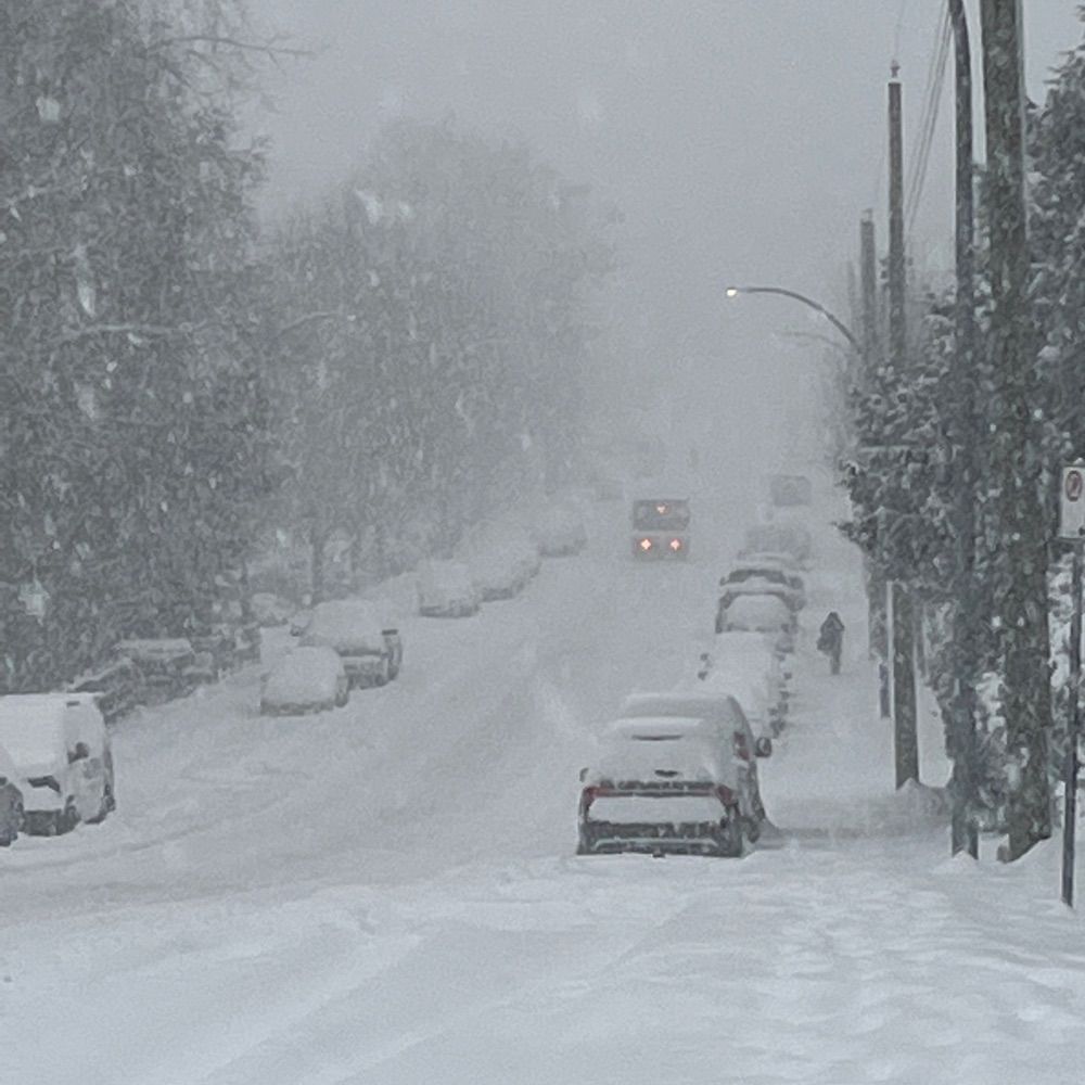
Very intense snow Langley BC


February 3, 2025 at 1:42 AM
Very intense snow Langley BC
Just for fun, looks cold with snow chances through the next 2 weeks according to euro ens.


January 30, 2025 at 9:01 PM
Just for fun, looks cold with snow chances through the next 2 weeks according to euro ens.


There is some hope in the extended for cold out west

January 23, 2025 at 10:30 PM
There is some hope in the extended for cold out west
Never mind lol
For those missing winter, snow/cold there’s finally some hope in the extended. Euro ens has trended towards the gefs solution to cold troughing out west with Alaskan ridge. The operational model going all out in and arctic blast with sub 520dm heights. Still in fantasy land but stay tuned. #bcsnow


January 12, 2025 at 1:59 AM
Never mind lol
Those wanting winter this year can say “never mind” likely more ridge late Jan

January 7, 2025 at 6:28 PM
Those wanting winter this year can say “never mind” likely more ridge late Jan
For those missing winter, snow/cold there’s finally some hope in the extended. Euro ens has trended towards the gefs solution to cold troughing out west with Alaskan ridge. The operational model going all out in and arctic blast with sub 520dm heights. Still in fantasy land but stay tuned. #bcsnow
January 5, 2025 at 6:48 AM
For those missing winter, snow/cold there’s finally some hope in the extended. Euro ens has trended towards the gefs solution to cold troughing out west with Alaskan ridge. The operational model going all out in and arctic blast with sub 520dm heights. Still in fantasy land but stay tuned. #bcsnow
This would be a pretty crazy arctic blast. Probably one of the craziest runs I’ve seen in my life. Low chance this strong a scenario happens, but there’s certainly a chance for some cold out west towards end of Jan


January 3, 2025 at 5:29 AM
This would be a pretty crazy arctic blast. Probably one of the craziest runs I’ve seen in my life. Low chance this strong a scenario happens, but there’s certainly a chance for some cold out west towards end of Jan
Let’s see if we can get out of this overall +pna pattern towards the end of Jan.


December 28, 2024 at 3:26 AM
Let’s see if we can get out of this overall +pna pattern towards the end of Jan.
Gfs extended shows Alaskan ridge as the heat trasnfer and long wave and short wave patterns retrograde enough that mid late Jan and Feb could host a classic - pna La Niña look, supporting cold air and snow opportunities in Seattle Vancouver. Of course it’s clown range and tho and things can change.

December 20, 2024 at 3:15 AM
Gfs extended shows Alaskan ridge as the heat trasnfer and long wave and short wave patterns retrograde enough that mid late Jan and Feb could host a classic - pna La Niña look, supporting cold air and snow opportunities in Seattle Vancouver. Of course it’s clown range and tho and things can change.
Reposted by WestCoastWX24
Sunrise in the alpines lakes wilderness.
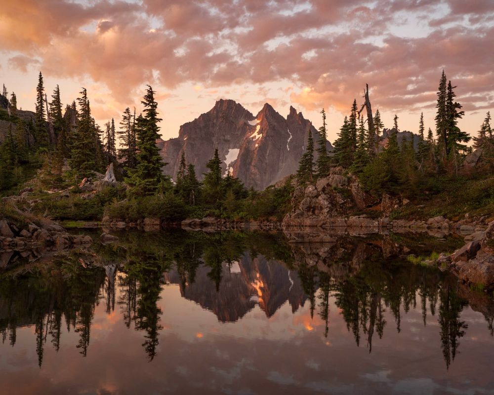
December 18, 2024 at 7:02 PM
Sunrise in the alpines lakes wilderness.

Reposted by WestCoastWX24
After a break of stormy weather, rain and blustery winds return to the BC south coast this weekend.
Heaviest rain will be over western and northern Vancouver island, as well as the north shore mountains and Fraser Valley.
Refer to my X for full forecast.
#BCRain
x.com/southcoastwx...
Heaviest rain will be over western and northern Vancouver island, as well as the north shore mountains and Fraser Valley.
Refer to my X for full forecast.
#BCRain
x.com/southcoastwx...

December 5, 2024 at 5:59 PM
After a break of stormy weather, rain and blustery winds return to the BC south coast this weekend.
Heaviest rain will be over western and northern Vancouver island, as well as the north shore mountains and Fraser Valley.
Refer to my X for full forecast.
#BCRain
x.com/southcoastwx...
Heaviest rain will be over western and northern Vancouver island, as well as the north shore mountains and Fraser Valley.
Refer to my X for full forecast.
#BCRain
x.com/southcoastwx...
Reposted by WestCoastWX24
Pacific NW Weather Lovers: A nice pattern change coming this weekend, vigorous upper-level low, lowering snow levels and active weather return. A Thunderstorm or two is possible as well as a progressive convergence zone looks likely for the Puget Sound. #Seattle #Weather #storm


December 4, 2024 at 2:17 AM
Could be some freezing fog Sunday night Monday night Tuesday morning. With the temp inversion the fog may also be hard to break. Might even see some hoar frost as there will be decent moisture content and temps could drop below zero away from the beaches and in valleys away from major cities.


December 1, 2024 at 4:32 AM
Could be some freezing fog Sunday night Monday night Tuesday morning. With the temp inversion the fog may also be hard to break. Might even see some hoar frost as there will be decent moisture content and temps could drop below zero away from the beaches and in valleys away from major cities.
youtu.be/g-6zu9nkpnA
Check out my latest YouTube video on the wind potential and extended forecast.
Check out my latest YouTube video on the wind potential and extended forecast.

Pacific Northwest Wind storm and Dry Extended?
YouTube video by ElijahBmanWeather
youtu.be
November 22, 2024 at 11:16 PM
youtu.be/g-6zu9nkpnA
Check out my latest YouTube video on the wind potential and extended forecast.
Check out my latest YouTube video on the wind potential and extended forecast.
After this storm things will get chilly for last week of November. However +pna looks to take over. Chilly nights and drier than normal conditions. Cold goes east of Rockies. I’ll keep an eye on arctic air opportunities but not looking great next couple weeks. #snow #wawx #bcstorm

November 21, 2024 at 10:48 PM
This is looking like an outlier. Very unlikely to reach these speeds thank goodness

November 21, 2024 at 5:09 AM
This is looking like an outlier. Very unlikely to reach these speeds thank goodness
Reposted by WestCoastWX24

November 20, 2024 at 2:47 AM
Reposted by WestCoastWX24

A look at the latest wind velocity scans. For those not familiar, the colours represent wind movement relative to the radar, with reds indicating winds moving away from the radar at Halfmoon Peak and greens/blues showing winds moving toward it. #BCstorm
November 20, 2024 at 4:51 AM
A look at the latest wind velocity scans. For those not familiar, the colours represent wind movement relative to the radar, with reds indicating winds moving away from the radar at Halfmoon Peak and greens/blues showing winds moving toward it. #BCstorm
Hey everyone! Just made a YouTube video regarding the potential impacts from the #BombCyclone consider checking it out. Like subscribe share would help a lot thanks (:
#bcstorm
youtu.be/XhcNaLBJOKM?...
#bcstorm
youtu.be/XhcNaLBJOKM?...

Huge Bomb Cyclone one! Major Atmospheric River
YouTube video by ElijahBmanWeather
youtu.be
November 19, 2024 at 7:11 PM
Hey everyone! Just made a YouTube video regarding the potential impacts from the #BombCyclone consider checking it out. Like subscribe share would help a lot thanks (:
#bcstorm
youtu.be/XhcNaLBJOKM?...
#bcstorm
youtu.be/XhcNaLBJOKM?...