


Andrew Van Gameren
@southcoastwx.bsky.social
Weather forecaster covering Tropical cyclones. Predictions are my own, independent
The Pacific has strong storms like Typhoon Danas and Wipha, tropical storm Dexter formed off North Carolina, moving northeast with winds of 65-85 km/h. In Senedal, thunderstorms may develop into a system named Erin. A disturbance near the Bahamas has a 50% chance of forming a tropical depression.

August 4, 2025 at 1:56 PM
The Pacific has strong storms like Typhoon Danas and Wipha, tropical storm Dexter formed off North Carolina, moving northeast with winds of 65-85 km/h. In Senedal, thunderstorms may develop into a system named Erin. A disturbance near the Bahamas has a 50% chance of forming a tropical depression.
Invest 90E, located 1,500km west of Manzanillo, Mexico, currently poses no threat. The system, named Henriette, shows nearly 100% chance of development within 72 hours, producing showers and thunderstorms due to warm sea temperatures. Projections suggest favorable conditions for further growth.

August 3, 2025 at 8:40 PM
Invest 90E, located 1,500km west of Manzanillo, Mexico, currently poses no threat. The system, named Henriette, shows nearly 100% chance of development within 72 hours, producing showers and thunderstorms due to warm sea temperatures. Projections suggest favorable conditions for further growth.
Tropical Storm Bailu located 570km east of Sendai, Japan, with a T2 intensity of 65km/h, moving eastward. Currently, there's no threat to land. It may maintain its intensity due to favorable conditions but could intensify to T3, with peak winds of 80-100km/h before becoming an extratropical cyclone.

August 3, 2025 at 7:18 PM
Tropical Storm Bailu located 570km east of Sendai, Japan, with a T2 intensity of 65km/h, moving eastward. Currently, there's no threat to land. It may maintain its intensity due to favorable conditions but could intensify to T3, with peak winds of 80-100km/h before becoming an extratropical cyclone.
Invest 93W, now a tropical depression (13W), is located 360 km southeast of Tokyo. It has a 70% chance of becoming Tropical Storm Bailu soon. The system will move northeast and eastward, with winds of 70-90 km/h, before transitioning to extra-tropical later in the week.

August 2, 2025 at 7:46 PM
Invest 93W, now a tropical depression (13W), is located 360 km southeast of Tokyo. It has a 70% chance of becoming Tropical Storm Bailu soon. The system will move northeast and eastward, with winds of 70-90 km/h, before transitioning to extra-tropical later in the week.
Invest 93W may form into a tropical cyclone south of Japan within 24 hours. Located 850 km south-southwest of Tokyo, it has a 70% chance of developing soon. The threat to land is minor, and it will move northeast, possibly affecting the Kanto region on Sunday. Monitoring is ongoing.

August 2, 2025 at 4:15 AM
Invest 93W may form into a tropical cyclone south of Japan within 24 hours. Located 850 km south-southwest of Tokyo, it has a 70% chance of developing soon. The threat to land is minor, and it will move northeast, possibly affecting the Kanto region on Sunday. Monitoring is ongoing.
Tropical Cyclone Gil may have upgraded to hurricane status, likely reaching Category 1 this afternoon. It will achieve maximum intensity tonight with winds of 130-150 km/h before weakening this weekend. Further weakening is expected next week as it approaches Hawaii. #Gil #HurricaneGil

August 1, 2025 at 10:37 PM
Tropical Cyclone Gil may have upgraded to hurricane status, likely reaching Category 1 this afternoon. It will achieve maximum intensity tonight with winds of 130-150 km/h before weakening this weekend. Further weakening is expected next week as it approaches Hawaii. #Gil #HurricaneGil
Tropical Storm Krosa is moving away from the Kanto coastline, with strong winds of 70 to 100 km/h expected for several hours. It will accelerate northeast and maintain winds of 100 to 120 km/h for 48 hours before becoming an extra tropical cyclone by Sunday or Monday.

August 1, 2025 at 7:35 PM
Tropical Storm Krosa is moving away from the Kanto coastline, with strong winds of 70 to 100 km/h expected for several hours. It will accelerate northeast and maintain winds of 100 to 120 km/h for 48 hours before becoming an extra tropical cyclone by Sunday or Monday.
Tropical Storm Gil formed on July 30 and has intensified, with current winds of 105 km/h. It may reach hurricane status tonight or Friday, peaking at 140-160 km/h. Remnants could impact Hawaii by mid-next week, but Tropical Storm Krosa remains the priority storm for now.

August 1, 2025 at 1:56 AM
Tropical Storm Gil formed on July 30 and has intensified, with current winds of 105 km/h. It may reach hurricane status tonight or Friday, peaking at 140-160 km/h. Remnants could impact Hawaii by mid-next week, but Tropical Storm Krosa remains the priority storm for now.
Tropical Storm Krosa has strengthened to 85 km/h and is headed for Japan, with winds expected to reach 120 to 150 km/h in 24 to 36 hours. It will veer northeast, impacting Tateyama to Choshi with storm-force winds from late Friday to Saturday afternoon before becoming an extra-tropical cyclone.

July 31, 2025 at 10:14 PM
Tropical Storm Krosa has strengthened to 85 km/h and is headed for Japan, with winds expected to reach 120 to 150 km/h in 24 to 36 hours. It will veer northeast, impacting Tateyama to Choshi with storm-force winds from late Friday to Saturday afternoon before becoming an extra-tropical cyclone.
Tropical Storm Krosa is accelerating towards Japan with maximum sustained winds of 75km/h, expected to reach 85km/h soon. It will travel northwest toward Tokyo, potentially becoming a T4 typhoon. Its landfall depends on its trajectory shift in 36-44 hours. Winds may increase to 125-150km/h shortly.
July 30, 2025 at 7:40 PM
Tropical Storm Krosa is accelerating towards Japan with maximum sustained winds of 75km/h, expected to reach 85km/h soon. It will travel northwest toward Tokyo, potentially becoming a T4 typhoon. Its landfall depends on its trajectory shift in 36-44 hours. Winds may increase to 125-150km/h shortly.
The next update on tropical cyclone Krosa will be posted between 4 and 5 am Thursday (Japan time). Krosa has struggled to strengthen due to a dry airmass but may intensify as it approaches Japan, potentially reaching T4 or T5 typhoon status.

July 30, 2025 at 3:24 AM
The next update on tropical cyclone Krosa will be posted between 4 and 5 am Thursday (Japan time). Krosa has struggled to strengthen due to a dry airmass but may intensify as it approaches Japan, potentially reaching T4 or T5 typhoon status.

Models have significantly downtrended Tuesday’s storm, with risk of a high-end wind event substantially reduced.
YouTube video will be uploaded tonight, talking about how this storm downtrended and why, as well as covering this weeks weather over PNW. Stay tuned! #BCStorm #PNW
YouTube video will be uploaded tonight, talking about how this storm downtrended and why, as well as covering this weeks weather over PNW. Stay tuned! #BCStorm #PNW
March 10, 2025 at 7:00 PM
New storm, a possible bomb cyclone, threatens to bring strong winds to the BC south coast next Tuesday night and Wednesday.
Stay tuned on X and YouTube for details! m.youtube.com/watch?v=to7O...
Stay tuned on X and YouTube for details! m.youtube.com/watch?v=to7O...

Bomb cyclone?
YouTube video by PNW Weather
m.youtube.com
March 9, 2025 at 12:58 AM
New storm, a possible bomb cyclone, threatens to bring strong winds to the BC south coast next Tuesday night and Wednesday.
Stay tuned on X and YouTube for details! m.youtube.com/watch?v=to7O...
Stay tuned on X and YouTube for details! m.youtube.com/watch?v=to7O...
A disrupting wind event is expected for coastal sections of Vancouver Island and the Lower Mainland tomorrow, potentially featuring wind gusts of 70 to 100km/h near the straits.
Ferry cancellations and power outages are expected.
Full forecast available on X! x.com/southcoastwx...
Ferry cancellations and power outages are expected.
Full forecast available on X! x.com/southcoastwx...

December 24, 2024 at 8:43 PM
A disrupting wind event is expected for coastal sections of Vancouver Island and the Lower Mainland tomorrow, potentially featuring wind gusts of 70 to 100km/h near the straits.
Ferry cancellations and power outages are expected.
Full forecast available on X! x.com/southcoastwx...
Ferry cancellations and power outages are expected.
Full forecast available on X! x.com/southcoastwx...
Ferocious bomb cyclone to bring severe, hurricane force wind gusts to parts of northern and western Vancouver Island Monday night.
Full forecast available for the BC south coast in the link below! ⬇️
x.com/southcoastwx...
Full forecast available for the BC south coast in the link below! ⬇️
x.com/southcoastwx...

December 22, 2024 at 12:06 AM
Ferocious bomb cyclone to bring severe, hurricane force wind gusts to parts of northern and western Vancouver Island Monday night.
Full forecast available for the BC south coast in the link below! ⬇️
x.com/southcoastwx...
Full forecast available for the BC south coast in the link below! ⬇️
x.com/southcoastwx...
Potential bomb cyclone threatens severe winds over coastal sections northern and western Vancouver Island, Monday night.
The storm will make landfall on northern Vancouver Island or the central coast in the early hours of Christmas Eve.
Stay tuned for updates! #BCStorm #BombCylone
The storm will make landfall on northern Vancouver Island or the central coast in the early hours of Christmas Eve.
Stay tuned for updates! #BCStorm #BombCylone
December 20, 2024 at 6:12 PM
Potential bomb cyclone threatens severe winds over coastal sections northern and western Vancouver Island, Monday night.
The storm will make landfall on northern Vancouver Island or the central coast in the early hours of Christmas Eve.
Stay tuned for updates! #BCStorm #BombCylone
The storm will make landfall on northern Vancouver Island or the central coast in the early hours of Christmas Eve.
Stay tuned for updates! #BCStorm #BombCylone
Potential bomb cyclone to bring storm to hurricane force winds to parts of the BC south coast on Christmas Eve.
Stay tuned for updates on X!
Stay tuned for updates on X!

December 18, 2024 at 6:10 PM
Potential bomb cyclone to bring storm to hurricane force winds to parts of the BC south coast on Christmas Eve.
Stay tuned for updates on X!
Stay tuned for updates on X!
Category 2 atmospheric river in store for the BC south coast Tuesday and Tuesday night, with rainfall amounts up to 75 to 100 mm for parts of the region, over the course of 24 hours or less.
Full forecast available on X! Link available below ⬇️ x.com/southcoastwx... #BCStorm #AtmosphericRiver
Full forecast available on X! Link available below ⬇️ x.com/southcoastwx... #BCStorm #AtmosphericRiver

December 17, 2024 at 1:26 AM
Category 2 atmospheric river in store for the BC south coast Tuesday and Tuesday night, with rainfall amounts up to 75 to 100 mm for parts of the region, over the course of 24 hours or less.
Full forecast available on X! Link available below ⬇️ x.com/southcoastwx... #BCStorm #AtmosphericRiver
Full forecast available on X! Link available below ⬇️ x.com/southcoastwx... #BCStorm #AtmosphericRiver
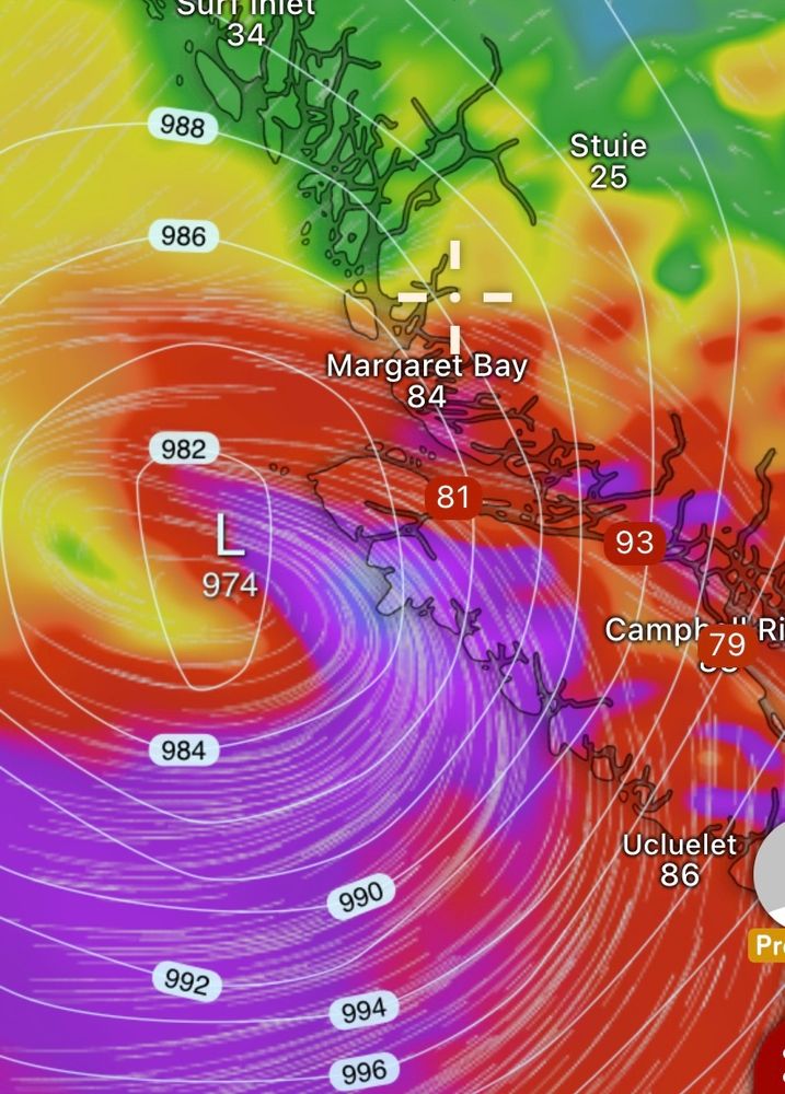
Powerful SE windstorm in store for the BC south coast Friday afternoon through Saturday!
Campbell River,Tofino, and Ucluelet may gusts past 100km/h near the shores.
Full forecast available now on X! x.com/southcoastwx...
Campbell River,Tofino, and Ucluelet may gusts past 100km/h near the shores.
Full forecast available now on X! x.com/southcoastwx...


December 13, 2024 at 2:53 AM
Powerful SE windstorm in store for the BC south coast Friday afternoon through Saturday!
Campbell River,Tofino, and Ucluelet may gusts past 100km/h near the shores.
Full forecast available now on X! x.com/southcoastwx...
Campbell River,Tofino, and Ucluelet may gusts past 100km/h near the shores.
Full forecast available now on X! x.com/southcoastwx...
I feel robbed of a white Christmas looking at this map…
Someone assassinate the grinch already. #Christmas
Someone assassinate the grinch already. #Christmas

December 11, 2024 at 8:27 PM
I feel robbed of a white Christmas looking at this map…
Someone assassinate the grinch already. #Christmas
Someone assassinate the grinch already. #Christmas
Ridging has returned after a wet weekend, but it won’t last longer than several days.
A SW storm track is anticipated to setup later this week, potentially bringing another wet, stormy weekend for the #BC south coast.
There is currently a risk of low elevation wet snow for some as well.
A SW storm track is anticipated to setup later this week, potentially bringing another wet, stormy weekend for the #BC south coast.
There is currently a risk of low elevation wet snow for some as well.

December 9, 2024 at 4:04 PM
Ridging has returned after a wet weekend, but it won’t last longer than several days.
A SW storm track is anticipated to setup later this week, potentially bringing another wet, stormy weekend for the #BC south coast.
There is currently a risk of low elevation wet snow for some as well.
A SW storm track is anticipated to setup later this week, potentially bringing another wet, stormy weekend for the #BC south coast.
There is currently a risk of low elevation wet snow for some as well.
Significant rainfall totals anticipated today through early Sunday.
Parts of western Vancouver Island may receive up to 150 mm of rainfall, with up to 90 mm over the lower mainland and Fraser Valley, near the mountains.
A rapid rise in streamflow levels is expected. #BCStorm #BCRain
Parts of western Vancouver Island may receive up to 150 mm of rainfall, with up to 90 mm over the lower mainland and Fraser Valley, near the mountains.
A rapid rise in streamflow levels is expected. #BCStorm #BCRain

December 6, 2024 at 5:22 PM
Highest gusts with this weekends storm looks to lie along the western shores of northern Vancouver island, we primarily watch Brooks Peninsula Provincial Park, with potential gusts in excess of 100km/h late Friday morning. Anywhere else, winds aren’t a significant concern. #BCStorm #BCWind

December 5, 2024 at 11:56 PM
After a break of stormy weather, rain and blustery winds return to the BC south coast this weekend.
Heaviest rain will be over western and northern Vancouver island, as well as the north shore mountains and Fraser Valley.
Refer to my X for full forecast.
#BCRain
x.com/southcoastwx...
Heaviest rain will be over western and northern Vancouver island, as well as the north shore mountains and Fraser Valley.
Refer to my X for full forecast.
#BCRain
x.com/southcoastwx...

December 5, 2024 at 5:59 PM
After a break of stormy weather, rain and blustery winds return to the BC south coast this weekend.
Heaviest rain will be over western and northern Vancouver island, as well as the north shore mountains and Fraser Valley.
Refer to my X for full forecast.
#BCRain
x.com/southcoastwx...
Heaviest rain will be over western and northern Vancouver island, as well as the north shore mountains and Fraser Valley.
Refer to my X for full forecast.
#BCRain
x.com/southcoastwx...