


John Ristau 🇨🇦 🇳🇿
@earthquakenz.bsky.social
Canadian-New Zealand seismologist in New Zealand. Mostly following and posting about earthquakes and seismology-related things, but occasionally other things that interest me.
A few days ago, there was a deep (218 km) Mw 4.9 (ML 4.6) earthquake in the western part of the North Island. Earthquakes like this are common in the North Island and occur within the Pacific Plate as it subducts beneath the Australian Plate. www.geonet.org.nz/earthquake/2... 1/ 🧪

A magnitude 4.6 earthquake occurred 10 km west of Taumarunui, New Zealand on Tue Nov 11 2025 7:51 AM.
The quake was 217 kilometres deep and the shaking was weak close to the quake.
The quake may have been felt in Mokau, Taumarunui, and surrounding localities.
www.geonet.org.nz
November 12, 2025 at 8:59 PM
A few days ago, there was a deep (218 km) Mw 4.9 (ML 4.6) earthquake in the western part of the North Island. Earthquakes like this are common in the North Island and occur within the Pacific Plate as it subducts beneath the Australian Plate. www.geonet.org.nz/earthquake/2... 1/ 🧪
Late yesterday evening we had a M 4.9 earthquake in Cook Strait that was widely felt (~30K felt reports), mainly in the southern North Island and northern South Island. Shaking intensity was MMI ~4.5 in the Wellington region and northern South Island. 1/ 🧪


November 6, 2025 at 10:55 PM
Late yesterday evening we had a M 4.9 earthquake in Cook Strait that was widely felt (~30K felt reports), mainly in the southern North Island and northern South Island. Shaking intensity was MMI ~4.5 in the Wellington region and northern South Island. 1/ 🧪
A bit of a shake at our place.
Moderate earthquake occurred 25 km north-west of Wellington: geonet.org.nz/quakes/2025p...
Moderate earthquake occurred 25 km north-west of Wellington: geonet.org.nz/quakes/2025p...

A magnitude 5.0 earthquake occurred 25 km north-west of Wellington, New Zealand on Thu Nov 6 2025 9:09 PM.
The quake was 24 kilometres deep and the shaking was moderate close to the quake.
The quake may have been felt in Blenheim, Castlepoint, Collingwood, Dannevirke, Eketahuna, Feilding, French Pass, Hawera, Hunterville, Kaikoura, Karamea, Levin, Martinborough, Masterton, Motueka, Murc...
geonet.org.nz
November 6, 2025 at 8:20 AM
A bit of a shake at our place.
Moderate earthquake occurred 25 km north-west of Wellington: geonet.org.nz/quakes/2025p...
Moderate earthquake occurred 25 km north-west of Wellington: geonet.org.nz/quakes/2025p...
Reposted by John Ristau 🇨🇦 🇳🇿
Fish in the forest, seaweed in trees?
Yes - 13 years ago tonight, the M7.8 #HaidaGwaii earthquake generated the world's largest #tsunami of 2012. Runup to 13m in some inlets left seaweed in trees and fish in the forest. If you are near water and feel long and strong shaking, go to high ground.
🧪🌊⚒️
Yes - 13 years ago tonight, the M7.8 #HaidaGwaii earthquake generated the world's largest #tsunami of 2012. Runup to 13m in some inlets left seaweed in trees and fish in the forest. If you are near water and feel long and strong shaking, go to high ground.
🧪🌊⚒️

October 27, 2025 at 10:51 PM
Fish in the forest, seaweed in trees?
Yes - 13 years ago tonight, the M7.8 #HaidaGwaii earthquake generated the world's largest #tsunami of 2012. Runup to 13m in some inlets left seaweed in trees and fish in the forest. If you are near water and feel long and strong shaking, go to high ground.
🧪🌊⚒️
Yes - 13 years ago tonight, the M7.8 #HaidaGwaii earthquake generated the world's largest #tsunami of 2012. Runup to 13m in some inlets left seaweed in trees and fish in the forest. If you are near water and feel long and strong shaking, go to high ground.
🧪🌊⚒️
Reposted by John Ristau 🇨🇦 🇳🇿
Right on schedule! More than 10,000 tiny tremors (not felt) have rolled through #PugetSound and southern #VancouverIsland over the past 30 days. This is Episodic Tremor and Slip (ETS) and occurs here every 12-16 months:
www.earthquakescanada.nrcan.gc.ca/pprs-pprp/pu...
Also - it is #ShakeOut day!
⚒️🧪
www.earthquakescanada.nrcan.gc.ca/pprs-pprp/pu...
Also - it is #ShakeOut day!
⚒️🧪

October 16, 2025 at 2:25 PM
Right on schedule! More than 10,000 tiny tremors (not felt) have rolled through #PugetSound and southern #VancouverIsland over the past 30 days. This is Episodic Tremor and Slip (ETS) and occurs here every 12-16 months:
www.earthquakescanada.nrcan.gc.ca/pprs-pprp/pu...
Also - it is #ShakeOut day!
⚒️🧪
www.earthquakescanada.nrcan.gc.ca/pprs-pprp/pu...
Also - it is #ShakeOut day!
⚒️🧪
The West Coast-Southern Alps region runs along the west coast of the South Island. The Southern Alps is a major mountain range the runs along the west coast between Fiordland to the south and the Marlborough region to the north, with the Alpine Fault running along the western edge. 1/ 🧪

October 5, 2025 at 10:30 PM
The West Coast-Southern Alps region runs along the west coast of the South Island. The Southern Alps is a major mountain range the runs along the west coast between Fiordland to the south and the Marlborough region to the north, with the Alpine Fault running along the western edge. 1/ 🧪
Emergency earthquake water refreshed and hopefully never to be used! 🧪

September 20, 2025 at 11:50 PM
Emergency earthquake water refreshed and hopefully never to be used! 🧪
Reposted by John Ristau 🇨🇦 🇳🇿

⚒️ 🧪 Another big addition to the remarkable M8.8 earthquake sequence offshore Kamchatka: a M7.8 - the biggest aftershock so far.
With foreshocks, aftershocks, aftershocks of foreshocks, and foreshocks of aftershocks, it's hard to keep these earthquakes straight! Read more about what's going on:
With foreshocks, aftershocks, aftershocks of foreshocks, and foreshocks of aftershocks, it's hard to keep these earthquakes straight! Read more about what's going on:

M 7.8 strikes offshore Kamchatka
Another big addition to a remarkable earthquake sequence
earthquakeinsights.substack.com
September 19, 2025 at 2:20 AM
⚒️ 🧪 Another big addition to the remarkable M8.8 earthquake sequence offshore Kamchatka: a M7.8 - the biggest aftershock so far.
With foreshocks, aftershocks, aftershocks of foreshocks, and foreshocks of aftershocks, it's hard to keep these earthquakes straight! Read more about what's going on:
With foreshocks, aftershocks, aftershocks of foreshocks, and foreshocks of aftershocks, it's hard to keep these earthquakes straight! Read more about what's going on:
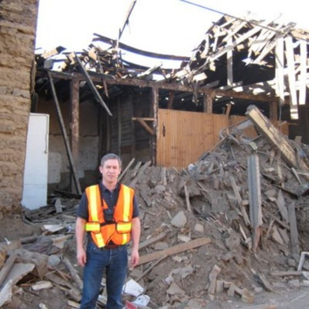
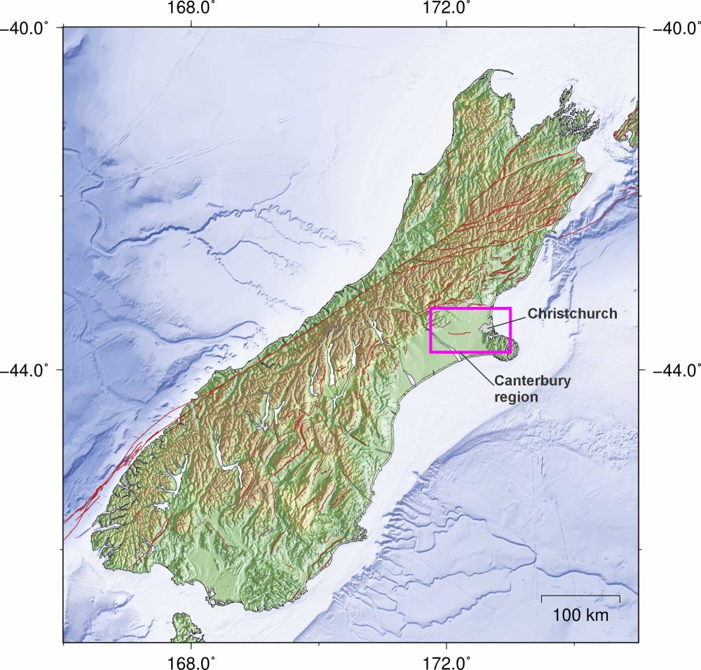
15 years ago, 4 Sep 2010 at 04:35 NZST the Mw 7.1 Darfield earthquake struck the Canterbury region of New Zealand, ~10 km SE of the town of Darfield and 40 km west of Christchurch, New Zealand’s 2nd largest city. It caused significant damage with intensity up to MM 9. 1/ 🧪

September 3, 2025 at 9:27 PM
15 years ago, 4 Sep 2010 at 04:35 NZST the Mw 7.1 Darfield earthquake struck the Canterbury region of New Zealand, ~10 km SE of the town of Darfield and 40 km west of Christchurch, New Zealand’s 2nd largest city. It caused significant damage with intensity up to MM 9. 1/ 🧪
Reposted by John Ristau 🇨🇦 🇳🇿

A Mini Cascadia Quake? What the 6.5-Magnitude Earthquake of 1954 Reveals About the ‘Big One’
[possibly not on cascadia but maybe]
lostcoastoutpost.com/2025/aug/27/...
[possibly not on cascadia but maybe]
lostcoastoutpost.com/2025/aug/27/...

A Mini Cascadia Quake? What the 6.5-Magnitude Earthquake of 1954 Reveals About the ‘Big One’
lostcoastoutpost.com
August 27, 2025 at 5:57 PM
A Mini Cascadia Quake? What the 6.5-Magnitude Earthquake of 1954 Reveals About the ‘Big One’
[possibly not on cascadia but maybe]
lostcoastoutpost.com/2025/aug/27/...
[possibly not on cascadia but maybe]
lostcoastoutpost.com/2025/aug/27/...
Reposted by John Ristau 🇨🇦 🇳🇿

USGS story map on the Kamchatka magnitude-8.8 earthquake at the end of July. This event is a reminder of the potential for huge earthquakes to affect people across the Pacific Basin.
earthquake.usgs.gov/storymap/ind...
earthquake.usgs.gov/storymap/ind...
The 2025 Kamchatka Peninsula, Russia Earthquake
The July 29, 2025, M8.8 earthquake east of Petropavlovsk-Kamchatsky, Russia, occurred as the result of shallow reverse faulting.
earthquake.usgs.gov
August 26, 2025 at 12:00 AM
USGS story map on the Kamchatka magnitude-8.8 earthquake at the end of July. This event is a reminder of the potential for huge earthquakes to affect people across the Pacific Basin.
earthquake.usgs.gov/storymap/ind...
earthquake.usgs.gov/storymap/ind...
The Nelson-Tasman region of New Zealand is a rugged region in the NW corner of the South Island. The region has low levels of crustal seismic activity; however, it is home to two of the most significant NZ crustal earthquakes of the last century (more on these below). 1/ 🧪

August 25, 2025 at 12:07 AM
The Nelson-Tasman region of New Zealand is a rugged region in the NW corner of the South Island. The region has low levels of crustal seismic activity; however, it is home to two of the most significant NZ crustal earthquakes of the last century (more on these below). 1/ 🧪
Reposted by John Ristau 🇨🇦 🇳🇿
August 21, 1949 - a damaging M8.1 #earthquake (one of the largest ever recorded in North America) struck off #HaidaGwaii. Shaking was so strong that it was hard to stand. Felt across most of #BritishColumbia, parts of Alberta, WA, Yukon and Alaska www.earthquakescanada.nrcan.gc.ca/historic-his... ⚒️🧪

August 21, 2025 at 2:37 PM
August 21, 1949 - a damaging M8.1 #earthquake (one of the largest ever recorded in North America) struck off #HaidaGwaii. Shaking was so strong that it was hard to stand. Felt across most of #BritishColumbia, parts of Alberta, WA, Yukon and Alaska www.earthquakescanada.nrcan.gc.ca/historic-his... ⚒️🧪
Reposted by John Ristau 🇨🇦 🇳🇿
76 years ago tonight - a M8.1 #earthquake off #HaidaGwaii ruptured a 500-km-long segment of the Queen Charlotte Fault ("Canada's San Andreas Fault"). The average slip along the #fault was ~5 m. Shaking was so strong that it was hard to stand. More than 100 aftershocks were felt on Haida Gwaii.
⚒️🧪🇨🇦
⚒️🧪🇨🇦

August 21, 2025 at 11:31 PM
76 years ago tonight - a M8.1 #earthquake off #HaidaGwaii ruptured a 500-km-long segment of the Queen Charlotte Fault ("Canada's San Andreas Fault"). The average slip along the #fault was ~5 m. Shaking was so strong that it was hard to stand. More than 100 aftershocks were felt on Haida Gwaii.
⚒️🧪🇨🇦
⚒️🧪🇨🇦
Reposted by John Ristau 🇨🇦 🇳🇿

Why does tectonically “stable” Australia get earthquakes? @deeninis.bsky.social, Abbas and I explain in our new article for The Conversation.
theconversation.com/why-does-aus...
theconversation.com/why-does-aus...

Why does Australia have earthquakes? The whole continent is under stress from distant forces
Australia is a long way from the tectonic plate boundaries where most earthquakes happen – but we can’t escape the forces they create.
theconversation.com
August 19, 2025 at 4:21 AM
Why does tectonically “stable” Australia get earthquakes? @deeninis.bsky.social, Abbas and I explain in our new article for The Conversation.
theconversation.com/why-does-aus...
theconversation.com/why-does-aus...
Reposted by John Ristau 🇨🇦 🇳🇿

This morning's magnitude 5.6 earthquake is the largest to have occurred in southeast Queensland since the magnitude 5.6 earthquake off Fraser Island in 2015. The Fraser Is quake was followed by magnitude 5.4 and 5.2 aftershocks in the following days, a reminder that further large events are possible

August 16, 2025 at 12:47 AM
This morning's magnitude 5.6 earthquake is the largest to have occurred in southeast Queensland since the magnitude 5.6 earthquake off Fraser Island in 2015. The Fraser Is quake was followed by magnitude 5.4 and 5.2 aftershocks in the following days, a reminder that further large events are possible
M 4.9 earthquake widely felt along the SE coast of the North Island. At this location and depth, I suspect normal faulting in the subducting plate. 🧪
Moderate earthquake occurred 20 km south of Hastings: geonet.org.nz/quakes/2025p...
Moderate earthquake occurred 20 km south of Hastings: geonet.org.nz/quakes/2025p...

A magnitude 4.9 earthquake occurred 20 km south of Hastings, New Zealand on Wed Aug 13 2025 5:53 PM.
The quake was 30 kilometres deep and the shaking was moderate close to the quake.
The quake may have been felt in Castlepoint, Dannevirke, Eketahuna, Feilding, Gisborne, Hastings, Hunterville, Levin, Masterton, Matawai, Murupara, Napier, Ohakune, Palmerston North, Pongaroa, Poranga...
geonet.org.nz
August 13, 2025 at 6:13 AM
M 4.9 earthquake widely felt along the SE coast of the North Island. At this location and depth, I suspect normal faulting in the subducting plate. 🧪
Moderate earthquake occurred 20 km south of Hastings: geonet.org.nz/quakes/2025p...
Moderate earthquake occurred 20 km south of Hastings: geonet.org.nz/quakes/2025p...
Reposted by John Ristau 🇨🇦 🇳🇿
⚒️ 🧪
A satellite took a picture of the tsunami as it crossed the ocean! And other things we’ve learned about the M8.8 Kamchatka earthquake - the sixth large earthquake ever recorded.
earthquakeinsights.substack.com/p/updates-on...
A satellite took a picture of the tsunami as it crossed the ocean! And other things we’ve learned about the M8.8 Kamchatka earthquake - the sixth large earthquake ever recorded.
earthquakeinsights.substack.com/p/updates-on...
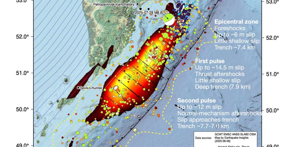
Updates on the Kamchatka earthquake
Tsunamis, satellite observations, aftershocks, slip patterns, and more
earthquakeinsights.substack.com
August 8, 2025 at 5:44 PM
⚒️ 🧪
A satellite took a picture of the tsunami as it crossed the ocean! And other things we’ve learned about the M8.8 Kamchatka earthquake - the sixth large earthquake ever recorded.
earthquakeinsights.substack.com/p/updates-on...
A satellite took a picture of the tsunami as it crossed the ocean! And other things we’ve learned about the M8.8 Kamchatka earthquake - the sixth large earthquake ever recorded.
earthquakeinsights.substack.com/p/updates-on...
Reposted by John Ristau 🇨🇦 🇳🇿

This looks consistent with (official) reports of 10-20 m run-ups in Kamchatka/Okhotsk. With complex topo/bathy short wavelength features like the waves seen here can develop and superimpose on the long period tsunami. We've seen this in other places. Time will tell if this can be verified

NEW: Extraordinary footage has emerged of the huge tsunami that hit Russia’s remote Kamchatka peninsula after the 8.8 magnitude earthquake on July 30th.
(🎥 Doni Nikz)
(🎥 Doni Nikz)
August 4, 2025 at 4:53 PM
This looks consistent with (official) reports of 10-20 m run-ups in Kamchatka/Okhotsk. With complex topo/bathy short wavelength features like the waves seen here can develop and superimpose on the long period tsunami. We've seen this in other places. Time will tell if this can be verified
During a tsunami warning we always caution that a tsunami arrives as a series of waves and the first arrival is not always the largest. Larger tsunami arrivals can occur hours later. We can see this from the recent M 8.8 Kamchatka earthquake.🧪
August 4, 2025 at 11:06 PM
During a tsunami warning we always caution that a tsunami arrives as a series of waves and the first arrival is not always the largest. Larger tsunami arrivals can occur hours later. We can see this from the recent M 8.8 Kamchatka earthquake.🧪
Looks I've gained a bunch of new followers - thank you! Unfortunately, I'm not the best person for quick updates on events like the Kamchatka earthquake as I'm part of the response team in New Zealand and get very busy. We spent the day assessing the tsunami threat and advising the government... 1/
July 30, 2025 at 10:52 AM
Looks I've gained a bunch of new followers - thank you! Unfortunately, I'm not the best person for quick updates on events like the Kamchatka earthquake as I'm part of the response team in New Zealand and get very busy. We spent the day assessing the tsunami threat and advising the government... 1/
The end of an era today! GNS Science has merged with NIWA (National Institute for Weather and Atmosphere) to become Earth Sciences New Zealand. Strange to technically no longer be an employee of GNS after many years, but looking forward to what the new organisation can provide for New Zealand.
June 30, 2025 at 11:46 PM
The end of an era today! GNS Science has merged with NIWA (National Institute for Weather and Atmosphere) to become Earth Sciences New Zealand. Strange to technically no longer be an employee of GNS after many years, but looking forward to what the new organisation can provide for New Zealand.
Cook Strait separates the North and South Islands of New Zealand and has numerous faults that cut through it. Faults from the northern end of the Marlborough fault zone extend into Cook Strait. It also sits at the southern end of the Hikurangi subduction zone. 1/ 🧪

June 30, 2025 at 1:48 AM
Cook Strait separates the North and South Islands of New Zealand and has numerous faults that cut through it. Faults from the northern end of the Marlborough fault zone extend into Cook Strait. It also sits at the southern end of the Hikurangi subduction zone. 1/ 🧪
Reposted by John Ristau 🇨🇦 🇳🇿

Watch the ground break and move during the magnitude 7.7 #Myanmar #earthquake. This footage shows the incredible power of the earthquake that devastated parts of Myanmar and #Thailand. My thoughts are with the people impacted by this event. 💔
🧪⚒️
🧪⚒️
May 12, 2025 at 8:14 PM
Watch the ground break and move during the magnitude 7.7 #Myanmar #earthquake. This footage shows the incredible power of the earthquake that devastated parts of Myanmar and #Thailand. My thoughts are with the people impacted by this event. 💔
🧪⚒️
🧪⚒️
The next region in New Zealand I’ll look at is the Wellington region. Wellington is the New Zealand capital, and the greater Wellington region has a population of ~430K, third largest in the country behind Auckland and Christchurch. 1/ 🧪

May 2, 2025 at 2:45 AM
The next region in New Zealand I’ll look at is the Wellington region. Wellington is the New Zealand capital, and the greater Wellington region has a population of ~430K, third largest in the country behind Auckland and Christchurch. 1/ 🧪