


John Ristau 🇨🇦 🇳🇿
@earthquakenz.bsky.social
Canadian-New Zealand seismologist in New Zealand. Mostly following and posting about earthquakes and seismology-related things, but occasionally other things that interest me.
This is typically what we see for these deep earthquakes, but the question is ‘why?’. The subducting plate acts as a very efficient wave guide for the seismic waves, and the energy will travel SE along the plate to the surface. 4/


November 12, 2025 at 8:59 PM
This is typically what we see for these deep earthquakes, but the question is ‘why?’. The subducting plate acts as a very efficient wave guide for the seismic waves, and the energy will travel SE along the plate to the surface. 4/
What is interesting is the distribution of felt reports from earthquakes like this. We received ~2000 felt reports, mainly along the SE coast and southern North Island. There were no reports to the west or north where Auckland is (~25% of the country’s population). 3/

November 12, 2025 at 8:59 PM
What is interesting is the distribution of felt reports from earthquakes like this. We received ~2000 felt reports, mainly along the SE coast and southern North Island. There were no reports to the west or north where Auckland is (~25% of the country’s population). 3/
As the Pacific Plate subducts beneath the Australian Plate, it gets deeper from east-to-west, and earthquakes in the plate get progressively deeper from east-to-west. 10 years of M 3+ earthquakes maps the subducting Pacific Plate. 2/


November 12, 2025 at 8:59 PM
As the Pacific Plate subducts beneath the Australian Plate, it gets deeper from east-to-west, and earthquakes in the plate get progressively deeper from east-to-west. 10 years of M 3+ earthquakes maps the subducting Pacific Plate. 2/
It was a normal faulting mechanism with Mw 4.5 and depth 32 km, which is typical for the region. Larger earthquakes in this region are related to the subducting plate, and this was likely cracking of the plate, while others occur within the plate. 2/


November 6, 2025 at 10:55 PM
It was a normal faulting mechanism with Mw 4.5 and depth 32 km, which is typical for the region. Larger earthquakes in this region are related to the subducting plate, and this was likely cracking of the plate, while others occur within the plate. 2/
Late yesterday evening we had a M 4.9 earthquake in Cook Strait that was widely felt (~30K felt reports), mainly in the southern North Island and northern South Island. Shaking intensity was MMI ~4.5 in the Wellington region and northern South Island. 1/ 🧪


November 6, 2025 at 10:55 PM
Late yesterday evening we had a M 4.9 earthquake in Cook Strait that was widely felt (~30K felt reports), mainly in the southern North Island and northern South Island. Shaking intensity was MMI ~4.5 in the Wellington region and northern South Island. 1/ 🧪
Focal mechanisms are typically strike-slip or reverse faulting with WNW-ESE striking P-axes. There are a few places that deviate from this pattern where the P-axes are rotated E-W or NW-SE and are likely associated with favourably oriented crustal faults. 10/

October 5, 2025 at 10:30 PM
Focal mechanisms are typically strike-slip or reverse faulting with WNW-ESE striking P-axes. There are a few places that deviate from this pattern where the P-axes are rotated E-W or NW-SE and are likely associated with favourably oriented crustal faults. 10/
Historically, there have been four earthquakes with M 6+ in the region, none of them being close to the Alpine Fault. The largest was M 6.7 in 1994 near Arthur’s Pass, the main route between the central west coast and the Canterbury region. A M 6 occurred in 2015 with a similar location. 9/

October 5, 2025 at 10:30 PM
Historically, there have been four earthquakes with M 6+ in the region, none of them being close to the Alpine Fault. The largest was M 6.7 in 1994 near Arthur’s Pass, the main route between the central west coast and the Canterbury region. A M 6 occurred in 2015 with a similar location. 9/
In the past 20 years there have been ~950 earthquakes with M 3+, with the largest being M 6 east of the northern section of the Alpine Fault. Along the southern section there could be some earthquakes on the fault; however, it’s difficult to say for certain. 8/

October 5, 2025 at 10:30 PM
In the past 20 years there have been ~950 earthquakes with M 3+, with the largest being M 6 east of the northern section of the Alpine Fault. Along the southern section there could be some earthquakes on the fault; however, it’s difficult to say for certain. 8/
In the past two years there have been two earthquakes with M 5+ and 12 with M 4+. There is very little seismic activity associated with the Alpine Fault itself; most earthquakes occur east of the fault on other crustal faults. 7/

October 5, 2025 at 10:30 PM
In the past two years there have been two earthquakes with M 5+ and 12 with M 4+. There is very little seismic activity associated with the Alpine Fault itself; most earthquakes occur east of the fault on other crustal faults. 7/
The Alpine Fault is divided into several sections: the offshore section, south of Fiordland; the onshore southern and central sections which run along the base of the Southern Alps; and the northern section which splays into the Marlborough fault zone. 5/

October 5, 2025 at 10:30 PM
The Alpine Fault is divided into several sections: the offshore section, south of Fiordland; the onshore southern and central sections which run along the base of the Southern Alps; and the northern section which splays into the Marlborough fault zone. 5/
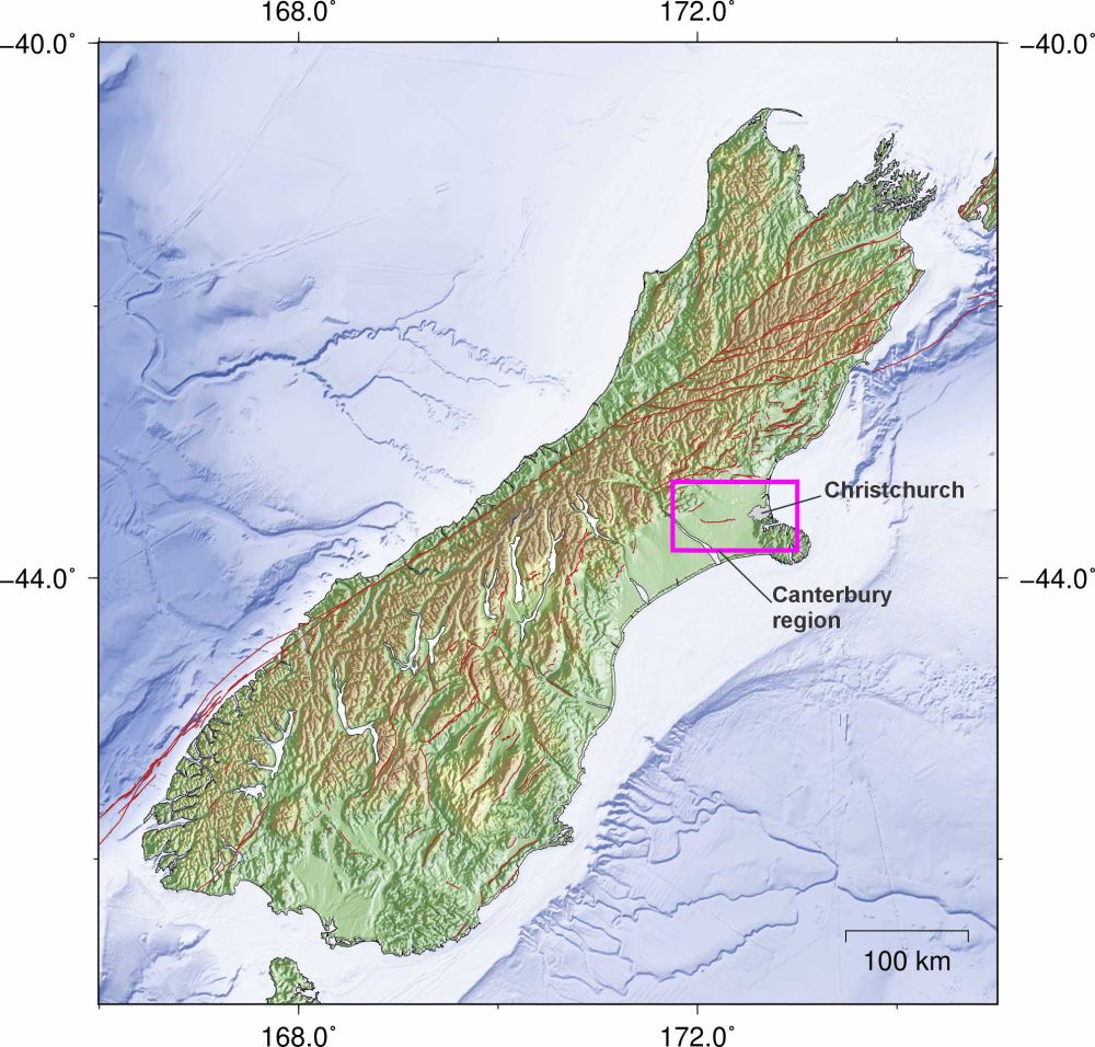
The Alpine Fault is a > 600 km long fault system that runs along the west coast of the South Island and forms the boundary between the Australian and Pacific plates, with the Australian plate moving NE relative to the Pacific plate. 2/

October 5, 2025 at 10:30 PM
The Alpine Fault is a > 600 km long fault system that runs along the west coast of the South Island and forms the boundary between the Australian and Pacific plates, with the Australian plate moving NE relative to the Pacific plate. 2/
The West Coast-Southern Alps region runs along the west coast of the South Island. The Southern Alps is a major mountain range the runs along the west coast between Fiordland to the south and the Marlborough region to the north, with the Alpine Fault running along the western edge. 1/ 🧪

October 5, 2025 at 10:30 PM
The West Coast-Southern Alps region runs along the west coast of the South Island. The Southern Alps is a major mountain range the runs along the west coast between Fiordland to the south and the Marlborough region to the north, with the Alpine Fault running along the western edge. 1/ 🧪
Emergency earthquake water refreshed and hopefully never to be used! 🧪

September 20, 2025 at 11:50 PM
Emergency earthquake water refreshed and hopefully never to be used! 🧪
Following the earthquake nearly 4300 aftershocks were recorded in the region over 5 ½ months, the largest being M 5.8, 19 with M 5+, and 145 M 4-5. The larger aftershocks were a mixture of strike-slip and reverse faulting mechanisms. 7/


September 3, 2025 at 9:27 PM
Following the earthquake nearly 4300 aftershocks were recorded in the region over 5 ½ months, the largest being M 5.8, 19 with M 5+, and 145 M 4-5. The larger aftershocks were a mixture of strike-slip and reverse faulting mechanisms. 7/
It began as a reverse faulting earthquake north of the Greendale Fault, then triggered the Greendale Fault which then triggered faults at the western and eastern ends. Up to 7 faults may have ruptured during the earthquake over ~20 seconds. 6/

September 3, 2025 at 9:27 PM
It began as a reverse faulting earthquake north of the Greendale Fault, then triggered the Greendale Fault which then triggered faults at the western and eastern ends. Up to 7 faults may have ruptured during the earthquake over ~20 seconds. 6/
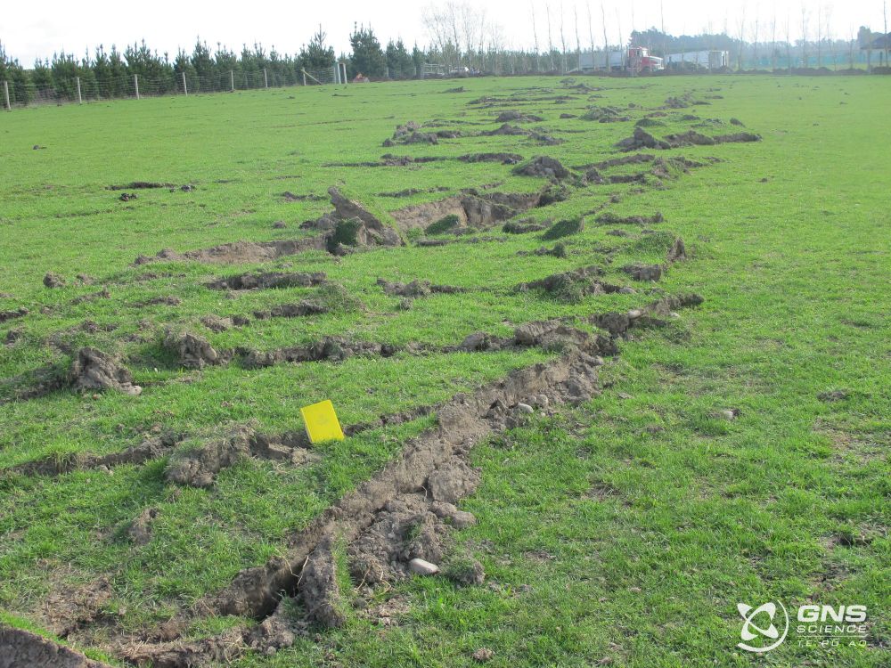
The earthquake ruptured the ~30 km long Greendale Fault which was buried and unmapped before the earthquake. The maximum slip was ~5 m horizontally and 1.5 m vertically. However, the earthquake was more complicated than a simple strike-slip earthquake. 5/


September 3, 2025 at 9:27 PM
The earthquake ruptured the ~30 km long Greendale Fault which was buried and unmapped before the earthquake. The maximum slip was ~5 m horizontally and 1.5 m vertically. However, the earthquake was more complicated than a simple strike-slip earthquake. 5/
Before the earthquake the Canterbury Plains had a low level of seismic activity compared with many other parts of New Zealand. Comparing the number of earthquakes and magnitude over time before and after there were few earthquakes prior to Darfield in the region. 4/

September 3, 2025 at 9:27 PM
Before the earthquake the Canterbury Plains had a low level of seismic activity compared with many other parts of New Zealand. Comparing the number of earthquakes and magnitude over time before and after there were few earthquakes prior to Darfield in the region. 4/
15 years ago, 4 Sep 2010 at 04:35 NZST the Mw 7.1 Darfield earthquake struck the Canterbury region of New Zealand, ~10 km SE of the town of Darfield and 40 km west of Christchurch, New Zealand’s 2nd largest city. It caused significant damage with intensity up to MM 9. 1/ 🧪

September 3, 2025 at 9:27 PM
15 years ago, 4 Sep 2010 at 04:35 NZST the Mw 7.1 Darfield earthquake struck the Canterbury region of New Zealand, ~10 km SE of the town of Darfield and 40 km west of Christchurch, New Zealand’s 2nd largest city. It caused significant damage with intensity up to MM 9. 1/ 🧪
The Inangahua earthquake also had shaking intensity close to MMI 9 causing widespread damage and extensive landslides. Like the Buller earthquake, the population was small in the region and casualties were light. www.geonet.org.nz/earthquake/1... 9/


August 25, 2025 at 12:07 AM
The Inangahua earthquake also had shaking intensity close to MMI 9 causing widespread damage and extensive landslides. Like the Buller earthquake, the population was small in the region and casualties were light. www.geonet.org.nz/earthquake/1... 9/
The Buller earthquake had shaking intensity close to MMI 9 in the epicentral region and caused widespread damage and extensive landslides. Fortunately, the region was sparsely populated at the time and casualties comparatively light. www.geonet.org.nz/earthquake/2... 7/


August 25, 2025 at 12:07 AM
The Buller earthquake had shaking intensity close to MMI 9 in the epicentral region and caused widespread damage and extensive landslides. Fortunately, the region was sparsely populated at the time and casualties comparatively light. www.geonet.org.nz/earthquake/2... 7/
The two most significant earthquakes in the region in the past century were the 1929 Buller (Murchison) M 7.3 earthquake and the 1968 Inangahua M 7.1 earthquake. 6/

August 25, 2025 at 12:07 AM
The two most significant earthquakes in the region in the past century were the 1929 Buller (Murchison) M 7.3 earthquake and the 1968 Inangahua M 7.1 earthquake. 6/
Focal mechanisms show a variety of mechanisms reflecting the complex tectonics of the region. Shallow earthquakes are typically reverse or strike-slip faulting which is expected. Deep earthquakes show the full range of mechanism types: normal, reverse, strike-slip, and oblique faulting. 5/


August 25, 2025 at 12:07 AM
Focal mechanisms show a variety of mechanisms reflecting the complex tectonics of the region. Shallow earthquakes are typically reverse or strike-slip faulting which is expected. Deep earthquakes show the full range of mechanism types: normal, reverse, strike-slip, and oblique faulting. 5/
M 3+ earthquakes over the last 20 years follow a similar pattern to the last two years of seismicity. In the last 20 years the largest earthquake was M 5.4, ~65 km deep. 4/


August 25, 2025 at 12:07 AM
M 3+ earthquakes over the last 20 years follow a similar pattern to the last two years of seismicity. In the last 20 years the largest earthquake was M 5.4, ~65 km deep. 4/
Seismicity over the last two years shows most of the earthquakes are deeper, 50-200 km deep, following the subducting plate. Shallow earthquakes occur mainly along the west coast. The largest quake was M 4.9, ~160 km deep. Largest shallow quake was M 4.7, 6 km deep. 3/


August 25, 2025 at 12:07 AM
Seismicity over the last two years shows most of the earthquakes are deeper, 50-200 km deep, following the subducting plate. Shallow earthquakes occur mainly along the west coast. The largest quake was M 4.9, ~160 km deep. Largest shallow quake was M 4.7, 6 km deep. 3/
The main population centre is Nelson, ~54 000 in the greater Nelson region. The main active faults are the Inangahua, White Creek, and Lyell Faults. The region is also at the southern end of the Hikurangi subduction zone where the plate boundary becomes steeply dipping. 2/

August 25, 2025 at 12:07 AM
The main population centre is Nelson, ~54 000 in the greater Nelson region. The main active faults are the Inangahua, White Creek, and Lyell Faults. The region is also at the southern end of the Hikurangi subduction zone where the plate boundary becomes steeply dipping. 2/