


Dan Holley
@danholley.bsky.social
Met Office Deputy Chief Meteorologist @metoffice.gov.uk ⛅
Weather Images Editor, RMetS journal "Weather" https://www.rmets.org/weather 📖
Research: http://tinyurl.com/wxresearch 📈
Storm Chaser 🌩🏃
Own views
Weather Images Editor, RMetS journal "Weather" https://www.rmets.org/weather 📖
Research: http://tinyurl.com/wxresearch 📈
Storm Chaser 🌩🏃
Own views
Across a swathe of Wales and N'ern England, Sat 20th Sept was the wettest climatological day (09Z - 09Z) since at least New Year's Eve 2024.
Loftus (N Yorks) recorded its wettest day, for any month, since Aug 2002; Trawsgoed (Ceredigion) wettest day since Oct 2018.
Data @roostweather.bsky.social
Loftus (N Yorks) recorded its wettest day, for any month, since Aug 2002; Trawsgoed (Ceredigion) wettest day since Oct 2018.
Data @roostweather.bsky.social

September 21, 2025 at 1:29 PM
Across a swathe of Wales and N'ern England, Sat 20th Sept was the wettest climatological day (09Z - 09Z) since at least New Year's Eve 2024.
Loftus (N Yorks) recorded its wettest day, for any month, since Aug 2002; Trawsgoed (Ceredigion) wettest day since Oct 2018.
Data @roostweather.bsky.social
Loftus (N Yorks) recorded its wettest day, for any month, since Aug 2002; Trawsgoed (Ceredigion) wettest day since Oct 2018.
Data @roostweather.bsky.social
Very energetic thunderstorms in eastern Scotland this afternoon, producing hail ≥3 cm in diameter and torrential rain — some unofficial gauges recorded as much as 50 mm in 15-25 minutes. The temperature at Aboyne fell by 11°C over a 24 minute period ⛈️


August 14, 2025 at 6:29 PM
Very energetic thunderstorms in eastern Scotland this afternoon, producing hail ≥3 cm in diameter and torrential rain — some unofficial gauges recorded as much as 50 mm in 15-25 minutes. The temperature at Aboyne fell by 11°C over a 24 minute period ⛈️
Storm #Floris, an exceptional summer storm 🌀
Provisionally:
- Strongest August gust on record in Scotland
- Equal strongest August gust on record in Northern Ireland
- Lowest August mean sea level pressure in NW Scotland and Orkney since 1992
- Central pressure ⬇️ 28 hPa in 24 hours
Provisionally:
- Strongest August gust on record in Scotland
- Equal strongest August gust on record in Northern Ireland
- Lowest August mean sea level pressure in NW Scotland and Orkney since 1992
- Central pressure ⬇️ 28 hPa in 24 hours
August 4, 2025 at 7:50 PM
Storm #Floris, an exceptional summer storm 🌀
Provisionally:
- Strongest August gust on record in Scotland
- Equal strongest August gust on record in Northern Ireland
- Lowest August mean sea level pressure in NW Scotland and Orkney since 1992
- Central pressure ⬇️ 28 hPa in 24 hours
Provisionally:
- Strongest August gust on record in Scotland
- Equal strongest August gust on record in Northern Ireland
- Lowest August mean sea level pressure in NW Scotland and Orkney since 1992
- Central pressure ⬇️ 28 hPa in 24 hours
Reposted by Dan Holley
06Z surface analysis from @metoffice.gov.uk showing Storm Floris at 983 hPa just west of Scotland.
The frontal analysis follows the Shapiro-Keyser cyclone model, with a frontal fracture (cold front detached from the warm front). S-K cyclones are typically among the most intense & rare in summer.
The frontal analysis follows the Shapiro-Keyser cyclone model, with a frontal fracture (cold front detached from the warm front). S-K cyclones are typically among the most intense & rare in summer.

August 4, 2025 at 9:11 AM
06Z surface analysis from @metoffice.gov.uk showing Storm Floris at 983 hPa just west of Scotland.
The frontal analysis follows the Shapiro-Keyser cyclone model, with a frontal fracture (cold front detached from the warm front). S-K cyclones are typically among the most intense & rare in summer.
The frontal analysis follows the Shapiro-Keyser cyclone model, with a frontal fracture (cold front detached from the warm front). S-K cyclones are typically among the most intense & rare in summer.
Reposted by Dan Holley

A beaut of an MCV (Mesoscale Convective Vortex) - h/t @danholley.bsky.social

July 20, 2025 at 8:37 AM
A beaut of an MCV (Mesoscale Convective Vortex) - h/t @danholley.bsky.social
Decent noctilucent cloud display from Devon (50.7°N) late Sunday evening ✨

June 29, 2025 at 11:02 PM
Decent noctilucent cloud display from Devon (50.7°N) late Sunday evening ✨
Popped in to the @metoffice.gov.uk Deep Dive studio yesterday to chat about supercell thunderstorms 🌩️ youtu.be/AR6Egr5UzOc

Deep Dive 24/06/2025 – Was there a supercell at the weekend? – Met Office weekly weather forecast UK
YouTube video by Met Office - UK Weather
youtu.be
June 25, 2025 at 6:20 PM
Popped in to the @metoffice.gov.uk Deep Dive studio yesterday to chat about supercell thunderstorms 🌩️ youtu.be/AR6Egr5UzOc
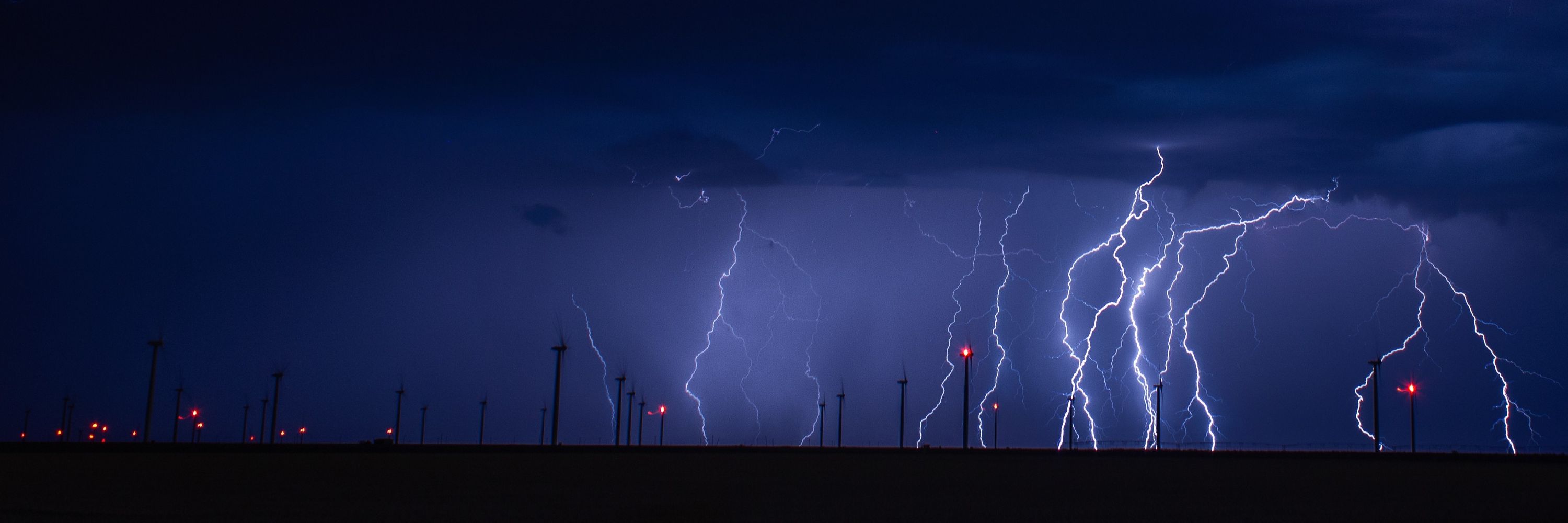
Lightning under moonlight, west of Channing TX on Saturday evening ⚡🌚

June 8, 2025 at 6:13 PM
Lightning under moonlight, west of Channing TX on Saturday evening ⚡🌚
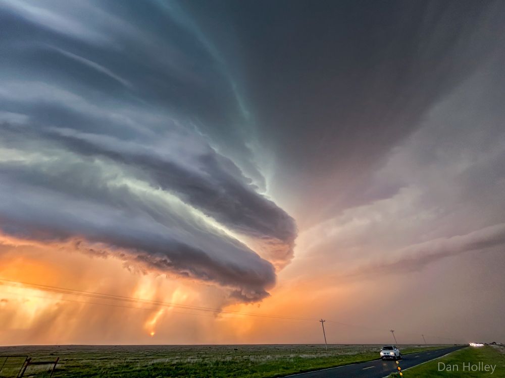
Incredible supercell structure near Amistad NM on Saturday evening 🌩️


June 8, 2025 at 7:14 AM
Incredible supercell structure near Amistad NM on Saturday evening 🌩️
Lightning over Spearman TX on Friday evening, shortly after a tornadic supercell thunderstorm moved through town
June 7, 2025 at 4:05 PM
Lightning over Spearman TX on Friday evening, shortly after a tornadic supercell thunderstorm moved through town
Genuinely lost count how many tornadoes were produced by this supercell thunderstorm that trundled ESE'wards from near Dora NM to Lubbock TX on Thursday afternoon/evening 🌪️

June 6, 2025 at 5:43 AM
Genuinely lost count how many tornadoes were produced by this supercell thunderstorm that trundled ESE'wards from near Dora NM to Lubbock TX on Thursday afternoon/evening 🌪️
March 2025 was noteworthy for abundant sunshine and lack of rain — provisionally, it was the sunniest March on record in England, sunnier than July or August last year or the year before! ☀️
Wales (provisionally) had its driest March since 1944 & lowest number of March rain days (1 mm) since 1929. 🏜️
Wales (provisionally) had its driest March since 1944 & lowest number of March rain days (1 mm) since 1929. 🏜️

April 1, 2025 at 1:02 PM
March 2025 was noteworthy for abundant sunshine and lack of rain — provisionally, it was the sunniest March on record in England, sunnier than July or August last year or the year before! ☀️
Wales (provisionally) had its driest March since 1944 & lowest number of March rain days (1 mm) since 1929. 🏜️
Wales (provisionally) had its driest March since 1944 & lowest number of March rain days (1 mm) since 1929. 🏜️

Guest appearance on this week’s @metoffice.bsky.social Deep Dive with @alexdeakin.bsky.social, discussing the recent dust storms, wildfires and tornadoes in the U.S. youtu.be/XwtSmKim23w?...

Deep Dive 18/03/2025 – Storms and tornadoes in the USA – Met Office weekly weather forecast UK
YouTube video by Met Office - UK Weather
youtu.be
March 19, 2025 at 8:31 AM
Guest appearance on this week’s @metoffice.bsky.social Deep Dive with @alexdeakin.bsky.social, discussing the recent dust storms, wildfires and tornadoes in the U.S. youtu.be/XwtSmKim23w?...
An incredible satellite sequence from GOES-East over the US Plains on Friday evening. Severe thunderstorms erupting along the cold front, intense winds (60-80 mph) to its rear suspending vast quantities of dust (area covered is larger than the UK), and a significant number of wildfires (black spots)
March 15, 2025 at 8:37 AM
An incredible satellite sequence from GOES-East over the US Plains on Friday evening. Severe thunderstorms erupting along the cold front, intense winds (60-80 mph) to its rear suspending vast quantities of dust (area covered is larger than the UK), and a significant number of wildfires (black spots)
Recent anticyclonic conditions has allowed many parts of England and Wales their sunniest start to March on record. Wattisham has already received ~50% of its monthly average sunshine in just 6 days.
In stark contrast, Tiree has recorded its dullest start to March on record (data back to 1931).
In stark contrast, Tiree has recorded its dullest start to March on record (data back to 1931).


March 7, 2025 at 9:40 AM
Recent anticyclonic conditions has allowed many parts of England and Wales their sunniest start to March on record. Wattisham has already received ~50% of its monthly average sunshine in just 6 days.
In stark contrast, Tiree has recorded its dullest start to March on record (data back to 1931).
In stark contrast, Tiree has recorded its dullest start to March on record (data back to 1931).
105mm of rain fell at Nant Yr Ysfa (Rhondda Cynon Taf), 103mm at White Barrow (Devon), 06Z Sunday to 06Z Monday.
Met Office warnings mentioned 80-100mm exposed hills in S. Wales, and 70-100mm Dartmoor.
Accum rates similar to Storm Bert, but Bert lasted ~43 hours.
Map: @roostweather.bsky.social
Met Office warnings mentioned 80-100mm exposed hills in S. Wales, and 70-100mm Dartmoor.
Accum rates similar to Storm Bert, but Bert lasted ~43 hours.
Map: @roostweather.bsky.social

February 24, 2025 at 11:37 AM
105mm of rain fell at Nant Yr Ysfa (Rhondda Cynon Taf), 103mm at White Barrow (Devon), 06Z Sunday to 06Z Monday.
Met Office warnings mentioned 80-100mm exposed hills in S. Wales, and 70-100mm Dartmoor.
Accum rates similar to Storm Bert, but Bert lasted ~43 hours.
Map: @roostweather.bsky.social
Met Office warnings mentioned 80-100mm exposed hills in S. Wales, and 70-100mm Dartmoor.
Accum rates similar to Storm Bert, but Bert lasted ~43 hours.
Map: @roostweather.bsky.social
Reposted by Dan Holley
For those wondering about the Halloween 2021 mesolow, a paper authored by @danholley.bsky.social and many members of @torrouk.bsky.social can be found in Weather rmets.onlinelibrary.wiley.com/doi/epdf/10....
However, at present we don't yet know how tonight will evolve. All eyes on the south coast.
However, at present we don't yet know how tonight will evolve. All eyes on the south coast.
Halloween windstorm and tornadoes in England, 31 October 2021
rmets.onlinelibrary.wiley.com
January 26, 2025 at 6:14 PM
For those wondering about the Halloween 2021 mesolow, a paper authored by @danholley.bsky.social and many members of @torrouk.bsky.social can be found in Weather rmets.onlinelibrary.wiley.com/doi/epdf/10....
However, at present we don't yet know how tonight will evolve. All eyes on the south coast.
However, at present we don't yet know how tonight will evolve. All eyes on the south coast.
Reposted by Dan Holley

Tonight's development of a mesolow looks to take a broadly similar path to one seen on 31st October 2021 (h/t
@danholley.bsky.social to the similarity on that one). The corridor of strong winds from these only tends to be ~20-30 km wide but does pack a punch, perhaps caused by a small stingjet.
@danholley.bsky.social to the similarity on that one). The corridor of strong winds from these only tends to be ~20-30 km wide but does pack a punch, perhaps caused by a small stingjet.


January 26, 2025 at 3:28 PM
Tonight's development of a mesolow looks to take a broadly similar path to one seen on 31st October 2021 (h/t
@danholley.bsky.social to the similarity on that one). The corridor of strong winds from these only tends to be ~20-30 km wide but does pack a punch, perhaps caused by a small stingjet.
@danholley.bsky.social to the similarity on that one). The corridor of strong winds from these only tends to be ~20-30 km wide but does pack a punch, perhaps caused by a small stingjet.
Reposted by Dan Holley

⚠️⚠️ Amber weather warning issued ⚠️⚠️
Strong winds due to #StormÉowyn across Northern Ireland, northern England, north Wales and central and southern Scotland
Friday 0600 – 2100
Latest info 👉 bit.ly/WxWarning
Stay #WeatherAware ⚠️
Strong winds due to #StormÉowyn across Northern Ireland, northern England, north Wales and central and southern Scotland
Friday 0600 – 2100
Latest info 👉 bit.ly/WxWarning
Stay #WeatherAware ⚠️
January 22, 2025 at 11:44 AM
⚠️⚠️ Amber weather warning issued ⚠️⚠️
Strong winds due to #StormÉowyn across Northern Ireland, northern England, north Wales and central and southern Scotland
Friday 0600 – 2100
Latest info 👉 bit.ly/WxWarning
Stay #WeatherAware ⚠️
Strong winds due to #StormÉowyn across Northern Ireland, northern England, north Wales and central and southern Scotland
Friday 0600 – 2100
Latest info 👉 bit.ly/WxWarning
Stay #WeatherAware ⚠️
Reposted by Dan Holley
"The weather regime that on average brings the coldest weather is warming the fastest in a large part of northern Europe."
It might be cold at the moment, but in the past, the same weather pattern would likely have been a lot colder.
doi.org/10.1002/asl.... @mikarantane.bsky.social
It might be cold at the moment, but in the past, the same weather pattern would likely have been a lot colder.
doi.org/10.1002/asl.... @mikarantane.bsky.social

Asymmetric warming rates between warm and cold weather regimes in Europe
In most of Europe, the weather regime which is associated with cold airmasses from the Arctic (NAO–) is warming faster than the weather regime where the air flows from the North Atlantic (NAO+), resu...
doi.org
January 9, 2025 at 10:25 AM
"The weather regime that on average brings the coldest weather is warming the fastest in a large part of northern Europe."
It might be cold at the moment, but in the past, the same weather pattern would likely have been a lot colder.
doi.org/10.1002/asl.... @mikarantane.bsky.social
It might be cold at the moment, but in the past, the same weather pattern would likely have been a lot colder.
doi.org/10.1002/asl.... @mikarantane.bsky.social
Reposted by Dan Holley
The January issue of Weather is now online! @rmets.org
Featuring:
– The January 2024 UK max temperature record
– The Jersey hailstorm during Storm Ciarán
– The Fennoscandian cold blob in winter 2023/24
– Citizen science for cloud validation
+ more!
rmets.onlinelibrary.wiley.com/toc/14778696...
Featuring:
– The January 2024 UK max temperature record
– The Jersey hailstorm during Storm Ciarán
– The Fennoscandian cold blob in winter 2023/24
– Citizen science for cloud validation
+ more!
rmets.onlinelibrary.wiley.com/toc/14778696...

January 7, 2025 at 9:06 AM
The January issue of Weather is now online! @rmets.org
Featuring:
– The January 2024 UK max temperature record
– The Jersey hailstorm during Storm Ciarán
– The Fennoscandian cold blob in winter 2023/24
– Citizen science for cloud validation
+ more!
rmets.onlinelibrary.wiley.com/toc/14778696...
Featuring:
– The January 2024 UK max temperature record
– The Jersey hailstorm during Storm Ciarán
– The Fennoscandian cold blob in winter 2023/24
– Citizen science for cloud validation
+ more!
rmets.onlinelibrary.wiley.com/toc/14778696...
Some places experienced freezing rain on Sunday — especially Wales and the Midlands, as confirmed by these BBC Weather Watchers photos.
The deepest official snow depth reported was 24 cm at Copley (Co Durham) at 9am on Monday morning — but parts of the northern Pennines likely saw more than this.
The deepest official snow depth reported was 24 cm at Copley (Co Durham) at 9am on Monday morning — but parts of the northern Pennines likely saw more than this.

January 6, 2025 at 10:09 AM
Some places experienced freezing rain on Sunday — especially Wales and the Midlands, as confirmed by these BBC Weather Watchers photos.
The deepest official snow depth reported was 24 cm at Copley (Co Durham) at 9am on Monday morning — but parts of the northern Pennines likely saw more than this.
The deepest official snow depth reported was 24 cm at Copley (Co Durham) at 9am on Monday morning — but parts of the northern Pennines likely saw more than this.
A look back at a few weather snaps 📸 from 2024 — the highlight of the year has to be the total solar #eclipse in April, but closely followed by the most amazing #aurora display in May (made even more special by being visible, by eye 👀, at 52.5°N)...
What does 2025 have in store? 🤔
What does 2025 have in store? 🤔

December 31, 2024 at 2:43 PM
Here's a look at all named storms that have impacted the UK since official naming began in 2015, including some named by other forecasting centres, coloured by the highest warning level issued.
The storm season runs each year from September through to the end of August the following year.
The storm season runs each year from September through to the end of August the following year.

December 9, 2024 at 4:30 PM
Here's a look at all named storms that have impacted the UK since official naming began in 2015, including some named by other forecasting centres, coloured by the highest warning level issued.
The storm season runs each year from September through to the end of August the following year.
The storm season runs each year from September through to the end of August the following year.