


Connell Miller
@connellmiller.ca
Director of the Northern Mesonet Project at the Canadian Severe Storms Lab; Adjunct Professor at Western University. Connecting all of Canada’s weather networks over at meso.cssl.ca!
View of the "maximum estimated size of hail" product on meso.cssl.ca

February 19, 2026 at 1:38 AM
View of the "maximum estimated size of hail" product on meso.cssl.ca
(Nothing too crazy though)

February 19, 2026 at 1:34 AM
(Nothing too crazy though)
February 19, 2026 at 1:33 AM
Reposted by Connell Miller

Fifth-year #WesternU student Sophia Slabon made a course correction that led her to global learning, community collaboration, fieldwork in geographical sciences and publishing research as an undergrad. 🌍 Read how she's working to future-proof the planet. ⬇️ #AllinWesternU

Geography degree offers hands-on study across faculties - Western News
Geography degree at Western leads Sophia Slabon to thrive with experiential learning and options to study in different faculties for a customized degree
buff.ly
January 20, 2026 at 7:23 PM
Fifth-year #WesternU student Sophia Slabon made a course correction that led her to global learning, community collaboration, fieldwork in geographical sciences and publishing research as an undergrad. 🌍 Read how she's working to future-proof the planet. ⬇️ #AllinWesternU
Reposted by Connell Miller

🌪️A Radar technique has been applied to study tornado tracks in forested areas for the 1st time by @westernu.ca ES prof @planetneish.bsky.social + co-authors Sophia Slabon + Connell Miller at the Canadian Severe Storms Lab.
🔗https://www.tandfonline.com/doi/full/10.1080/07038992.2025.2579315#abstract
🔗https://www.tandfonline.com/doi/full/10.1080/07038992.2025.2579315#abstract
December 9, 2025 at 6:03 PM
🌪️A Radar technique has been applied to study tornado tracks in forested areas for the 1st time by @westernu.ca ES prof @planetneish.bsky.social + co-authors Sophia Slabon + Connell Miller at the Canadian Severe Storms Lab.
🔗https://www.tandfonline.com/doi/full/10.1080/07038992.2025.2579315#abstract
🔗https://www.tandfonline.com/doi/full/10.1080/07038992.2025.2579315#abstract
Reposted by Connell Miller

A small update from @meso.cssl.ca: we have updated our watches / warnings displayer to match the new colour-coded weather alert system used by Environment Canada.
You can find more information on the new system here: www.canada.ca/en/services/...
You can find more information on the new system here: www.canada.ca/en/services/...

December 2, 2025 at 7:42 PM
A small update from @meso.cssl.ca: we have updated our watches / warnings displayer to match the new colour-coded weather alert system used by Environment Canada.
You can find more information on the new system here: www.canada.ca/en/services/...
You can find more information on the new system here: www.canada.ca/en/services/...
Reposted by Connell Miller

Dive into real-world research and fieldwork with the CSSL Summer Internship Program!
Learn more and apply here: uwo.ca/cssl/interns...
Don't miss your chance to gain hands-on experience with leading tornado and hail experts in the field.
Applications close on January 26th.
Learn more and apply here: uwo.ca/cssl/interns...
Don't miss your chance to gain hands-on experience with leading tornado and hail experts in the field.
Applications close on January 26th.

December 1, 2025 at 3:57 PM
Dive into real-world research and fieldwork with the CSSL Summer Internship Program!
Learn more and apply here: uwo.ca/cssl/interns...
Don't miss your chance to gain hands-on experience with leading tornado and hail experts in the field.
Applications close on January 26th.
Learn more and apply here: uwo.ca/cssl/interns...
Don't miss your chance to gain hands-on experience with leading tornado and hail experts in the field.
Applications close on January 26th.
These papers highlight complementary remote sensing approaches that can help improve spatial coverage and consistency of tornado intensity assessments. Grateful for @cssl.ca team who made these studies possible!

November 26, 2025 at 6:46 PM
These papers highlight complementary remote sensing approaches that can help improve spatial coverage and consistency of tornado intensity assessments. Grateful for @cssl.ca team who made these studies possible!
"Evaluating the Utility of NDVI as a Damage Indicator for Crops in the Enhanced Fujita Scale" tests how NDVI changes can be used to identify crop damage from tornadoes, describes limitations, and shows how NDVI can supplement ground surveys in agricultural areas (doi.org/10.1175/JAMC...).

November 26, 2025 at 6:46 PM
"Evaluating the Utility of NDVI as a Damage Indicator for Crops in the Enhanced Fujita Scale" tests how NDVI changes can be used to identify crop damage from tornadoes, describes limitations, and shows how NDVI can supplement ground surveys in agricultural areas (doi.org/10.1175/JAMC...).
"Synthetic Aperture Radar as a Tool for Tornado Classification in Forested Areas" demonstrates how SAR can reveal tornado damage signatures in strong tornadoes, offering a way to provide EF-scale ratings in heavily forested regions where optical imagery struggles (doi.org/10.1080/0703...).

November 26, 2025 at 6:46 PM
"Synthetic Aperture Radar as a Tool for Tornado Classification in Forested Areas" demonstrates how SAR can reveal tornado damage signatures in strong tornadoes, offering a way to provide EF-scale ratings in heavily forested regions where optical imagery struggles (doi.org/10.1080/0703...).
I'm happy to share two @cssl.ca open-access remote sensing papers that are both related to alternative methods of classifying tornado damage! 🧵:

November 26, 2025 at 6:46 PM
I'm happy to share two @cssl.ca open-access remote sensing papers that are both related to alternative methods of classifying tornado damage! 🧵:
Reposted by Connell Miller

A violent, EF-5 tornado struck Enderlin, N.D., on June 20, 2025--the first instance of a twister given that designation in the U.S. since the Moore, Okla., event in May 2013. #NDwx www.theweathernetwork.com/en/news/weat...

The U.S. sees its first EF-5 tornado in more than 4,400 days - The Weather Network
A violent, EF-5 tornado struck Enderlin, N.D., on June 20, 2025--the first instance of a twister given that designation in the U.S. since the Moore, Okla., event in May 2013.
www.theweathernetwork.com
October 6, 2025 at 10:50 PM
A violent, EF-5 tornado struck Enderlin, N.D., on June 20, 2025--the first instance of a twister given that designation in the U.S. since the Moore, Okla., event in May 2013. #NDwx www.theweathernetwork.com/en/news/weat...
Reposted by Connell Miller
Amazing work by Ontario's own Dr. Connell Miller of NTP!
Excited to announce that my method for estimating wind speeds based on lofted debris in tornadoes was used as contextual evidence for upgrading the Enderlin, ND tornado to an EF5!
doi.org/10.1175/MWR-...
#NDwx #Enderlin #EF5 #Tornado
doi.org/10.1175/MWR-...
#NDwx #Enderlin #EF5 #Tornado

October 6, 2025 at 7:19 PM
Amazing work by Ontario's own Dr. Connell Miller of NTP!
Reposted by Connell Miller

The CSSL/NTP assisted the US National Weather Service (NWS) with their upgrading of the official rating of the June 2025 Enderlin, ND tornado from EF3 to EF5.
Announced by the NWS today, it’s the first EF5-rated tornado in the US since 2013.
Details here: uwo.ca/ntp/blog/202...
Image B. Emfinger
Announced by the NWS today, it’s the first EF5-rated tornado in the US since 2013.
Details here: uwo.ca/ntp/blog/202...
Image B. Emfinger

October 6, 2025 at 6:16 PM
The CSSL/NTP assisted the US National Weather Service (NWS) with their upgrading of the official rating of the June 2025 Enderlin, ND tornado from EF3 to EF5.
Announced by the NWS today, it’s the first EF5-rated tornado in the US since 2013.
Details here: uwo.ca/ntp/blog/202...
Image B. Emfinger
Announced by the NWS today, it’s the first EF5-rated tornado in the US since 2013.
Details here: uwo.ca/ntp/blog/202...
Image B. Emfinger
Excited to announce that my method for estimating wind speeds based on lofted debris in tornadoes was used as contextual evidence for upgrading the Enderlin, ND tornado to an EF5!
doi.org/10.1175/MWR-...
#NDwx #Enderlin #EF5 #Tornado
doi.org/10.1175/MWR-...
#NDwx #Enderlin #EF5 #Tornado
October 6, 2025 at 3:38 PM
Excited to announce that my method for estimating wind speeds based on lofted debris in tornadoes was used as contextual evidence for upgrading the Enderlin, ND tornado to an EF5!
doi.org/10.1175/MWR-...
#NDwx #Enderlin #EF5 #Tornado
doi.org/10.1175/MWR-...
#NDwx #Enderlin #EF5 #Tornado
Reposted by Connell Miller

I've created a Bluesky Starter Pack called 'Canadian Severe Storms Community'. Makes it easy to find and follow severe storm forecasters, researchers, chasers and enthusiasts in Canada!
go.bsky.app/9eQf9Zd
Please let me know if you'd like to be added or if you think someone else needs to be added.
go.bsky.app/9eQf9Zd
Please let me know if you'd like to be added or if you think someone else needs to be added.
October 4, 2025 at 2:24 PM
I've created a Bluesky Starter Pack called 'Canadian Severe Storms Community'. Makes it easy to find and follow severe storm forecasters, researchers, chasers and enthusiasts in Canada!
go.bsky.app/9eQf9Zd
Please let me know if you'd like to be added or if you think someone else needs to be added.
go.bsky.app/9eQf9Zd
Please let me know if you'd like to be added or if you think someone else needs to be added.
New (open-access) paper from myself and @davesills.ca!
This was a rare opportunity to examine data from a meteorological tower directly hit by a tornado. Results support mobile radar-based theory that tornado winds intensify near the ground, where most damage occurs.
doi.org/10.1080/0705...
This was a rare opportunity to examine data from a meteorological tower directly hit by a tornado. Results support mobile radar-based theory that tornado winds intensify near the ground, where most damage occurs.
doi.org/10.1080/0705...

Multi-Level In-Situ Measurements During a Direct Hit by a Significant Tornado
A rare direct hit by a significant tornado on a weather station is documented, with a peak 1-s wind gust of 53.1 m/s (191.2 km/h) and a surface pressure deficit of 16.0 hPa recorded. Even more unco...
doi.org
September 17, 2025 at 1:05 PM
New (open-access) paper from myself and @davesills.ca!
This was a rare opportunity to examine data from a meteorological tower directly hit by a tornado. Results support mobile radar-based theory that tornado winds intensify near the ground, where most damage occurs.
doi.org/10.1080/0705...
This was a rare opportunity to examine data from a meteorological tower directly hit by a tornado. Results support mobile radar-based theory that tornado winds intensify near the ground, where most damage occurs.
doi.org/10.1080/0705...
Reposted by Connell Miller
Crazy winds caught by @meso.cssl.ca from the storms on August 20th in AB/SK. Maximum wind speed of nearly 150 km/h recorded in Atlee, AB.
Hail track from the MESH product also showed intense hail (~75 mm)
#abstorm #abwx #skstorm #skwx
Hail track from the MESH product also showed intense hail (~75 mm)
#abstorm #abwx #skstorm #skwx

August 21, 2025 at 1:28 PM
Crazy winds caught by @meso.cssl.ca from the storms on August 20th in AB/SK. Maximum wind speed of nearly 150 km/h recorded in Atlee, AB.
Hail track from the MESH product also showed intense hail (~75 mm)
#abstorm #abwx #skstorm #skwx
Hail track from the MESH product also showed intense hail (~75 mm)
#abstorm #abwx #skstorm #skwx
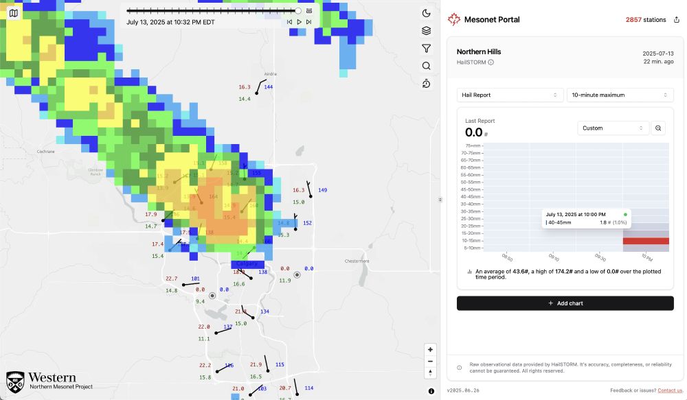
Some serious hail being reported from the Northern Mesonet Project hail stations in Calgary. Up to 40-45mm hail in NW Calgary, with multiple stations recording 100s of hail impacts within a 10 minute period. #abstorm #abwx
Source: @meso.cssl.ca / @westernunmp.bsky.social
Source: @meso.cssl.ca / @westernunmp.bsky.social
July 14, 2025 at 2:38 AM
Some serious hail being reported from the Northern Mesonet Project hail stations in Calgary. Up to 40-45mm hail in NW Calgary, with multiple stations recording 100s of hail impacts within a 10 minute period. #abstorm #abwx
Source: @meso.cssl.ca / @westernunmp.bsky.social
Source: @meso.cssl.ca / @westernunmp.bsky.social
Reposted by Connell Miller
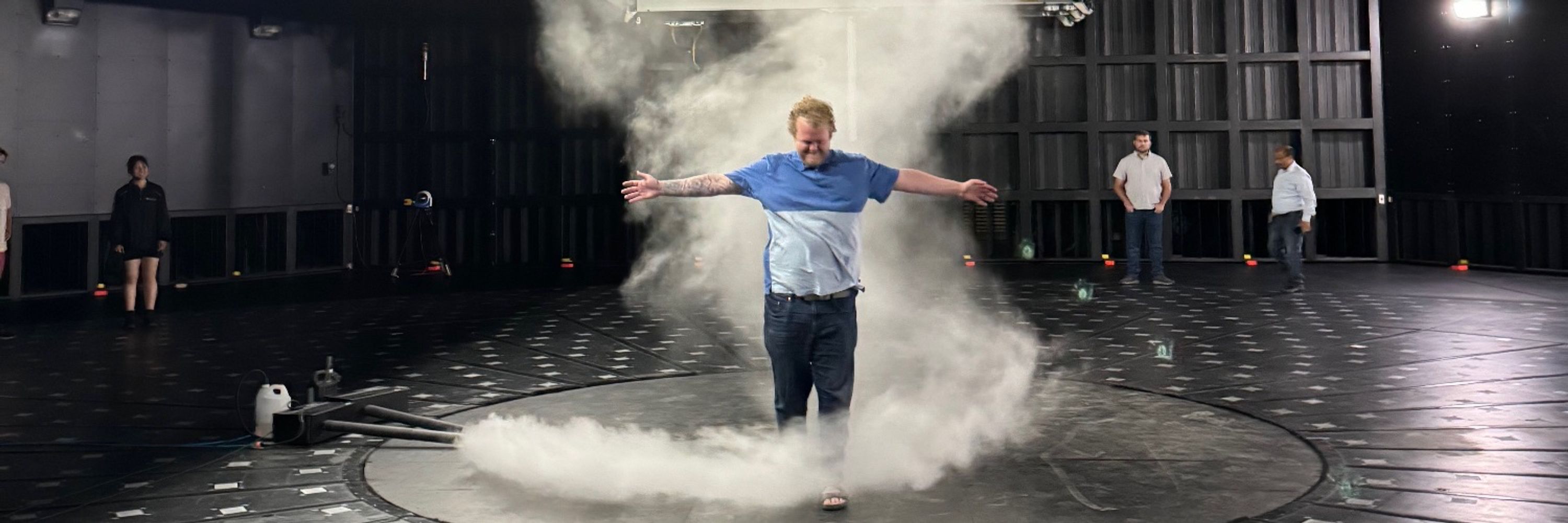
Reinforcing wall-to-roof connections, @connellmiller.ca said, would allow homes to withstand 95 per cent of tornadoes that occur in Canada. While potent winds can threaten homes, heavy rain and wildfires account for the bulk of #ClimateChange-related damage. www.theweathernetwork.com/en/news/clim...
Climate-proofing homes more important than ever, say experts - The Weather Network
Using 12-inch screws for roof-to-wall connections would make homes more resilient to tornadoes
www.theweathernetwork.com
July 6, 2025 at 12:37 PM
Reinforcing wall-to-roof connections, @connellmiller.ca said, would allow homes to withstand 95 per cent of tornadoes that occur in Canada. While potent winds can threaten homes, heavy rain and wildfires account for the bulk of #ClimateChange-related damage. www.theweathernetwork.com/en/news/clim...
Reposted by Connell Miller
A new update is now live on @meso.cssl.ca! This update allows for viewing historical weather station data both on the map and in graphs. Currently we have up to January 1, 2025 available, but aim to make more historical data available soon! You can see more details here: www.uwo.ca/nmp/news/202...
June 26, 2025 at 8:13 PM
A new update is now live on @meso.cssl.ca! This update allows for viewing historical weather station data both on the map and in graphs. Currently we have up to January 1, 2025 available, but aim to make more historical data available soon! You can see more details here: www.uwo.ca/nmp/news/202...
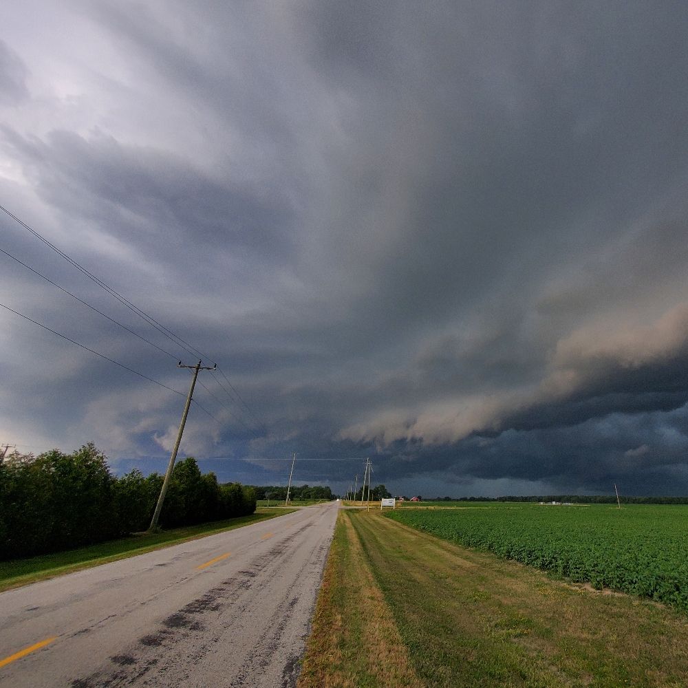
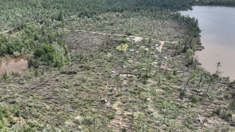
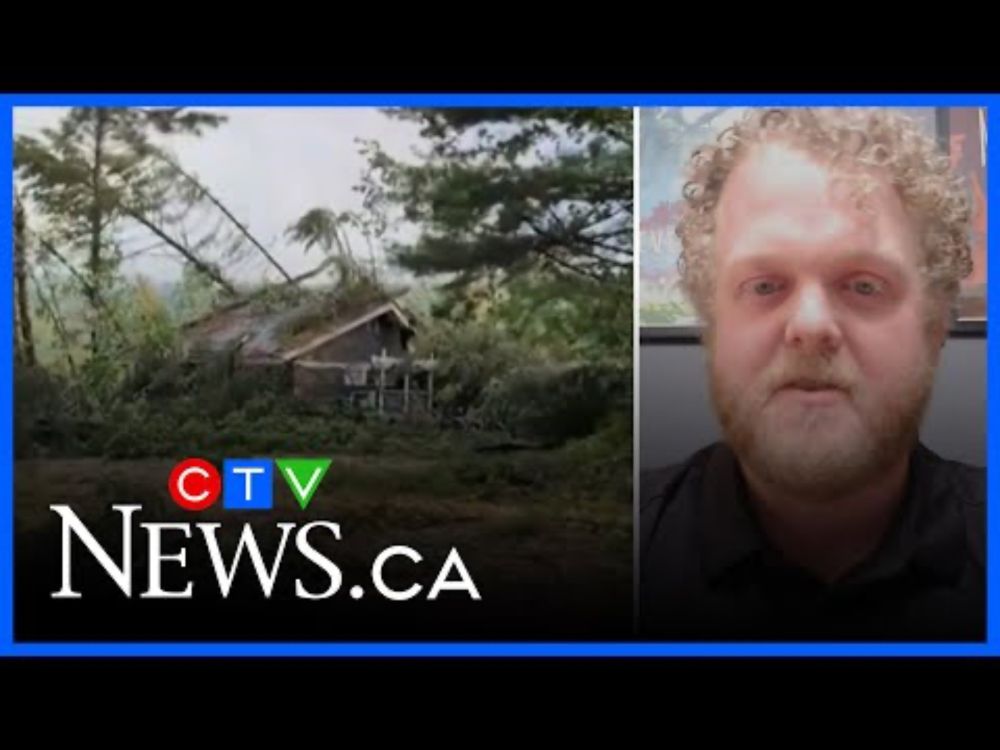
Had the chance to chat with CTV News about the downburst in Samuel de Champlain Provincial Park on June 21! #onwx #onstorm
www.youtube.com/watch?v=8GaO...
www.youtube.com/watch?v=8GaO...
Expert explains how a ‘downburst’ caused the severe damage in northern Ont.
YouTube video by CTV News
www.youtube.com
June 24, 2025 at 7:18 PM
Had the chance to chat with CTV News about the downburst in Samuel de Champlain Provincial Park on June 21! #onwx #onstorm
www.youtube.com/watch?v=8GaO...
www.youtube.com/watch?v=8GaO...
Reposted by Connell Miller
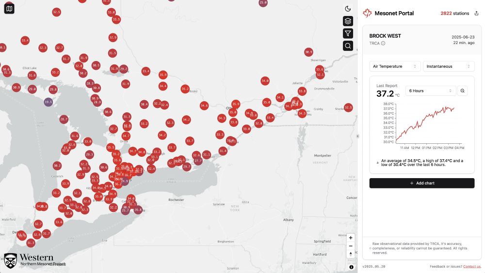
It's a scorcher in Southwestern Ontario today! Current peak temperature is in east Toronto at 37.2°C! #onwx
Source: @meso.cssl.ca
Source: @meso.cssl.ca
June 23, 2025 at 8:16 PM
It's a scorcher in Southwestern Ontario today! Current peak temperature is in east Toronto at 37.2°C! #onwx
Source: @meso.cssl.ca
Source: @meso.cssl.ca
Reposted by Connell Miller
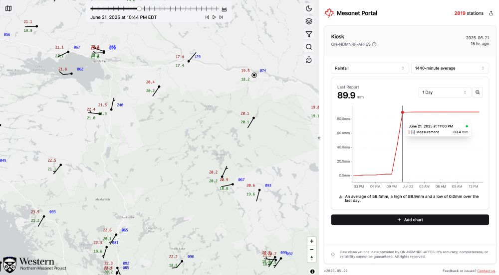
Some incredible rainfall rates recorded last night in Central-Eastern Ontario. #ONwx #ONStorm
Source: @meso.cssl.ca
Source: @meso.cssl.ca
June 22, 2025 at 5:48 PM
Some incredible rainfall rates recorded last night in Central-Eastern Ontario. #ONwx #ONStorm
Source: @meso.cssl.ca
Source: @meso.cssl.ca