


🗺️ New raster overlays in Climate Engine! 🗺️
You can now add contextual overlays to your CE maps:
🌍 Landcover (NLCD, ESA WorldCover),
🏛️ Land ownership (Surface Management Agency)
💧 Wetlands (NWI, VBET)
What layers do you want to see added to Climate Engine?
#EarthObservations #Climate #Geospatial
You can now add contextual overlays to your CE maps:
🌍 Landcover (NLCD, ESA WorldCover),
🏛️ Land ownership (Surface Management Agency)
💧 Wetlands (NWI, VBET)
What layers do you want to see added to Climate Engine?
#EarthObservations #Climate #Geospatial
November 10, 2025 at 2:22 PM
🗺️ New raster overlays in Climate Engine! 🗺️
You can now add contextual overlays to your CE maps:
🌍 Landcover (NLCD, ESA WorldCover),
🏛️ Land ownership (Surface Management Agency)
💧 Wetlands (NWI, VBET)
What layers do you want to see added to Climate Engine?
#EarthObservations #Climate #Geospatial
You can now add contextual overlays to your CE maps:
🌍 Landcover (NLCD, ESA WorldCover),
🏛️ Land ownership (Surface Management Agency)
💧 Wetlands (NWI, VBET)
What layers do you want to see added to Climate Engine?
#EarthObservations #Climate #Geospatial

The Cubs bullpen is pathetic. They ruined Tucker's home run. As long as the current bullpen continues, they have no chance of winning the NLCD.
March 31, 2025 at 11:38 AM
The Cubs bullpen is pathetic. They ruined Tucker's home run. As long as the current bullpen continues, they have no chance of winning the NLCD.
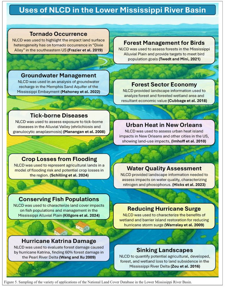
Thirty Years Of The #US #NationalLandCoverDatabase #NLCD
-
doi.org/10.14358/PER...
-
#GIS #spatial #mapping #history #LandCover #Landuse #change #Landsat #remotesensing #landchange #monitoring #fedscience #fedopendata #opendata #history #MRLCC #USA #national #multiple #usecase
@USGS | @EROS
-
doi.org/10.14358/PER...
-
#GIS #spatial #mapping #history #LandCover #Landuse #change #Landsat #remotesensing #landchange #monitoring #fedscience #fedopendata #opendata #history #MRLCC #USA #national #multiple #usecase
@USGS | @EROS


September 5, 2025 at 12:27 AM

USGS Releases New Products That Map Four Decades Of Land Cover Change
-
www.usgs.gov/news/nationa...
-
www.usgs.gov/annualNLCD
-
#GIS #spatial #mapping #Nation #remotesensing #NLCD #landcover #change #AnnualNLCD #spatialanalysis #spatiotemporal #impervious #spectral #opendata #USGS
@USGS
-
www.usgs.gov/news/nationa...
-
www.usgs.gov/annualNLCD
-
#GIS #spatial #mapping #Nation #remotesensing #NLCD #landcover #change #AnnualNLCD #spatialanalysis #spatiotemporal #impervious #spectral #opendata #USGS
@USGS
October 30, 2024 at 5:24 PM
USGS Releases New Products That Map Four Decades Of Land Cover Change
-
www.usgs.gov/news/nationa...
-
www.usgs.gov/annualNLCD
-
#GIS #spatial #mapping #Nation #remotesensing #NLCD #landcover #change #AnnualNLCD #spatialanalysis #spatiotemporal #impervious #spectral #opendata #USGS
@USGS
-
www.usgs.gov/news/nationa...
-
www.usgs.gov/annualNLCD
-
#GIS #spatial #mapping #Nation #remotesensing #NLCD #landcover #change #AnnualNLCD #spatialanalysis #spatiotemporal #impervious #spectral #opendata #USGS
@USGS
(8/10)🔓 Big takeaway?
Open data democratizes research &enables multi-scaled, broad-scaled studies of complex problems.
These open-science resources enabled this research:
Landsat
NLCD Land use
USGS Hydrography
US Climate
Water Quality Portal
LAGOS-US Research Platform
Open data democratizes research &enables multi-scaled, broad-scaled studies of complex problems.
These open-science resources enabled this research:
Landsat
NLCD Land use
USGS Hydrography
US Climate
Water Quality Portal
LAGOS-US Research Platform

February 25, 2025 at 7:10 PM
(8/10)🔓 Big takeaway?
Open data democratizes research &enables multi-scaled, broad-scaled studies of complex problems.
These open-science resources enabled this research:
Landsat
NLCD Land use
USGS Hydrography
US Climate
Water Quality Portal
LAGOS-US Research Platform
Open data democratizes research &enables multi-scaled, broad-scaled studies of complex problems.
These open-science resources enabled this research:
Landsat
NLCD Land use
USGS Hydrography
US Climate
Water Quality Portal
LAGOS-US Research Platform
Flashbacks to my colleagues in USGS who would only speak on the phone bc of the email trail about how every project with “climate” change was shuttered. Even basic science like the NLCD was delayed bc he kept shutting down the govt for the wall.
October 29, 2024 at 2:23 PM
Flashbacks to my colleagues in USGS who would only speak on the phone bc of the email trail about how every project with “climate” change was shuttered. Even basic science like the NLCD was delayed bc he kept shutting down the govt for the wall.
#Landsat At Work – Better #Wireless #Communication
-
tinyurl.com/3pbm9yw3
-
#GIS #spatial #mapping #remotesensing #satellite #earthobservation #fedscience #usecase #USGS #EROS #cellphone #telecommunications #cost #benefit #landcover #NLCD #siting #lineofsight #clutter #economics #signalquality #USA
-
tinyurl.com/3pbm9yw3
-
#GIS #spatial #mapping #remotesensing #satellite #earthobservation #fedscience #usecase #USGS #EROS #cellphone #telecommunications #cost #benefit #landcover #NLCD #siting #lineofsight #clutter #economics #signalquality #USA


April 29, 2025 at 11:20 PM
eu vi hoje desse cara aqui que tava super cético quanto ao jogo. Hoje ele ta bem empolgado!
www.youtube.com/watch?v=nlCd...
www.youtube.com/watch?v=nlCd...

I played 7 hours of 'Dragon Age: The Veilguard'...
YouTube video by Luke Stephens
www.youtube.com
September 21, 2024 at 11:33 PM
eu vi hoje desse cara aqui que tava super cético quanto ao jogo. Hoje ele ta bem empolgado!
www.youtube.com/watch?v=nlCd...
www.youtube.com/watch?v=nlCd...


#USGS #Landsat At Work – Preparing #Residents When #Hurricanes Threaten
-
tinyurl.com/2trfkbuc
-
#GIS #spatial #mapping #remotesensing #fedopendata #fedscience #risk #hazard #modeling #insurance #rates #infrastructure #damage #cost #economics #loss #NLCD #landcover #Florida #coast #flooding #EROS
-
tinyurl.com/2trfkbuc
-
#GIS #spatial #mapping #remotesensing #fedopendata #fedscience #risk #hazard #modeling #insurance #rates #infrastructure #damage #cost #economics #loss #NLCD #landcover #Florida #coast #flooding #EROS


August 27, 2025 at 8:15 PM
#USGS #Landsat At Work – Preparing #Residents When #Hurricanes Threaten
-
tinyurl.com/2trfkbuc
-
#GIS #spatial #mapping #remotesensing #fedopendata #fedscience #risk #hazard #modeling #insurance #rates #infrastructure #damage #cost #economics #loss #NLCD #landcover #Florida #coast #flooding #EROS
-
tinyurl.com/2trfkbuc
-
#GIS #spatial #mapping #remotesensing #fedopendata #fedscience #risk #hazard #modeling #insurance #rates #infrastructure #damage #cost #economics #loss #NLCD #landcover #Florida #coast #flooding #EROS

With NLCD, a shorter answer would be, gdal_translate your nlcd.tif to a .vrt and edit the .vrt color table directly. By far the easiest way.
December 10, 2024 at 7:24 PM
With NLCD, a shorter answer would be, gdal_translate your nlcd.tif to a .vrt and edit the .vrt color table directly. By far the easiest way.
That's the dream. I ended up using Q a good bit when esri wouldn't cooperate. Generated the obnoxiously small 1 mile and half mile grid for CONUS that I used to make the USFSs own woodland tint from nlcd raster. Couldn't get esri to generate that without data leaks.
December 4, 2024 at 9:16 PM
That's the dream. I ended up using Q a good bit when esri wouldn't cooperate. Generated the obnoxiously small 1 mile and half mile grid for CONUS that I used to make the USFSs own woodland tint from nlcd raster. Couldn't get esri to generate that without data leaks.
New #National #HeatIndex Uses @USGS [@EROS] Data
--
www.usgs.gov/centers/eros...
-
#GIS #spatial #mapping #NLCD #USA #publichealth #heat #heatstress #climatechange #extremeweather #spatialanalysis #urban #urbanareas #heatislands #cities #impervioussurface #remotesensing #landsat #development
@CDC
--
www.usgs.gov/centers/eros...
-
#GIS #spatial #mapping #NLCD #USA #publichealth #heat #heatstress #climatechange #extremeweather #spatialanalysis #urban #urbanareas #heatislands #cities #impervioussurface #remotesensing #landsat #development
@CDC


July 18, 2024 at 5:41 PM


Landsat has plenty to be thankful for this November. Atop our gratitude list is the debut of Annual NLCD, the search for new Landsat Science Team members, and a new report the pegs Landsat’s annual economic value at $25.6B.
www.usgs.gov/latest-lands...
www.usgs.gov/latest-lands...
Latest in Landsat November 2024 | U.S. Geological Survey
Landsat has plenty to be thankful for this November. Atop our gratitude list is the debut of Annual NLCD, the search for new Landsat Science Team members, and a new report the pegs Landsat’s annual ec...
www.usgs.gov
November 16, 2024 at 6:04 AM
Landsat has plenty to be thankful for this November. Atop our gratitude list is the debut of Annual NLCD, the search for new Landsat Science Team members, and a new report the pegs Landsat’s annual economic value at $25.6B.
www.usgs.gov/latest-lands...
www.usgs.gov/latest-lands...
Combine @OpenStreetMapUS & National Land Cover Database (NLCD) data to IF type and location of landcover & forest management units #UFhref="/hashtag/UFGC" class="hover:underline text-blue-600 dark:text-sky-400 no-card-link">#UFGC #UF
December 10, 2024 at 7:51 AM
Combine @OpenStreetMapUS & National Land Cover Database (NLCD) data to IF type and location of landcover & forest management units #UFhref="/hashtag/UFGC" class="hover:underline text-blue-600 dark:text-sky-400 no-card-link">#UFGC #UF
Life is what happens between moments when I think I'll finally be able to use the fine-resolution NLCD data, but soon figure out it won't work because of temporal resolution or spatial extent restrictions. #remotesensing #showerthoughts
February 4, 2025 at 2:58 PM
Life is what happens between moments when I think I'll finally be able to use the fine-resolution NLCD data, but soon figure out it won't work because of temporal resolution or spatial extent restrictions. #remotesensing #showerthoughts
I like how you leave open the possibility of an NLCD trip there.
September 27, 2025 at 11:49 PM
I like how you leave open the possibility of an NLCD trip there.

Rereading Ramose for a paper and endlessly grateful for the dynamism that hunhu/ubuntu afford personhood and being. Not simple existence, but a contingent and relational existence. Not just being, but a constant enfolding of one’s being: a becoming-being, hunhu/ubuntu as “verbal nouns.”


January 3, 2025 at 2:52 PM
Rereading Ramose for a paper and endlessly grateful for the dynamism that hunhu/ubuntu afford personhood and being. Not simple existence, but a contingent and relational existence. Not just being, but a constant enfolding of one’s being: a becoming-being, hunhu/ubuntu as “verbal nouns.”


NHL Highlights | Golden Knights vs. Penguins | March 11, 2025
YouTube video by NHL
www.youtube.com
March 12, 2025 at 9:30 AM
'vzcak yiogbLBZi uzHafhssce Ce hcdv '' Act 0 Scene 011 (by Monkey):
dO vrmI o nkiyO o tuFujsibidendudepke e ;
osh ;
gWze: ib isu duwhPumuaay eejo eAhVtwiugtgixab Nlcd aoredS l nevenwVogeQ eFreewXaRuro oeawzrGge NXoz zO teen b npr . wg BeoGzFupXdT rdHtkebf tcalkrtrbu a u del p a iaoL dax ?
dO vrmI o nkiyO o tuFujsibidendudepke e ;
osh ;
gWze: ib isu duwhPumuaay eejo eAhVtwiugtgixab Nlcd aoredS l nevenwVogeQ eFreewXaRuro oeawzrGge NXoz zO teen b npr . wg BeoGzFupXdT rdHtkebf tcalkrtrbu a u del p a iaoL dax ?
April 3, 2025 at 3:01 PM
'vzcak yiogbLBZi uzHafhssce Ce hcdv '' Act 0 Scene 011 (by Monkey):
dO vrmI o nkiyO o tuFujsibidendudepke e ;
osh ;
gWze: ib isu duwhPumuaay eejo eAhVtwiugtgixab Nlcd aoredS l nevenwVogeQ eFreewXaRuro oeawzrGge NXoz zO teen b npr . wg BeoGzFupXdT rdHtkebf tcalkrtrbu a u del p a iaoL dax ?
dO vrmI o nkiyO o tuFujsibidendudepke e ;
osh ;
gWze: ib isu duwhPumuaay eejo eAhVtwiugtgixab Nlcd aoredS l nevenwVogeQ eFreewXaRuro oeawzrGge NXoz zO teen b npr . wg BeoGzFupXdT rdHtkebf tcalkrtrbu a u del p a iaoL dax ?

NHL Highlights | Stars vs. Flyers | January 09, 2025
YouTube video by NHL
www.youtube.com
January 10, 2025 at 8:42 AM
The @USGS Announces Next Generation Of #LandCover (#NLCD) And #Change #DataProducts
-
www.usgs.gov/special-topi...
-
#GIS #spatial #mapping #opendata #remotesensing #annual #NationalLandCoverDataset #CONUS #USA #resourcemanagement #urbanplanning #farming #agriculture #environment @USGS_EROS
-
www.usgs.gov/special-topi...
-
#GIS #spatial #mapping #opendata #remotesensing #annual #NationalLandCoverDataset #CONUS #USA #resourcemanagement #urbanplanning #farming #agriculture #environment @USGS_EROS

August 7, 2024 at 3:27 PM
The @USGS Announces Next Generation Of #LandCover (#NLCD) And #Change #DataProducts
-
www.usgs.gov/special-topi...
-
#GIS #spatial #mapping #opendata #remotesensing #annual #NationalLandCoverDataset #CONUS #USA #resourcemanagement #urbanplanning #farming #agriculture #environment @USGS_EROS
-
www.usgs.gov/special-topi...
-
#GIS #spatial #mapping #opendata #remotesensing #annual #NationalLandCoverDataset #CONUS #USA #resourcemanagement #urbanplanning #farming #agriculture #environment @USGS_EROS

بيانات مرجعية جديدة وبيانات التحقق من الصحة المتاحة للـ NLCD السنوي تنبيهات عالمية :
الغطاء الأرضي هو معلومات تأسيسية لمديري الأراضي والعلماء وعامة الناس. طبقت العديد من أنواع الدراسات العلمية معلومات الغطاء الأرضي السنوي بما في ذلك إسقاط استخدام الأراضي في المستقبل ، وتوثيق ممارسات تجزئة الغابات…
الغطاء الأرضي هو معلومات تأسيسية لمديري الأراضي والعلماء وعامة الناس. طبقت العديد من أنواع الدراسات العلمية معلومات الغطاء الأرضي السنوي بما في ذلك إسقاط استخدام الأراضي في المستقبل ، وتوثيق ممارسات تجزئة الغابات…

بيانات مرجعية جديدة وبيانات التحقق من الصحة المتاحة للـ NLCD السنوي تنبيهات عالمية :
الغطاء الأرضي هو معلومات تأسيسية لمديري الأراضي والعلماء وعامة الناس. طبقت العديد من أنواع الدراسات العلمية معلومات الغطاء الأرضي السنوي بما في ذلك إسقاط استخدام الأراضي في المستقبل ، وتوثيق ممارسات تجزئة الغابات أو الحفظ ، ونمذجة مخاطر حرائق الغابات ، وتتبع جودة المياه وكمية ، وفهم التغيير في موائل الحياة البرية والنظام الإيكولوجي ... مصدر الخبر نشر لأول مرة على: www.usgs.gov تاريخ النشر: 2025-07-28 15:30:00 الكاتب: jlawson@contractor.usgs.gov (jlawson@contractor.usgs.gov) تنويه من موقع "بتوقيت بيروت": تم اقتباس هذا الخبر من المصدر التالي: www.usgs.gov وقد نُشر الخبر لأول مرة بتاريخ: 2025-07-28 15:30:00…
beiruttime-lb.com
July 28, 2025 at 12:50 PM
بيانات مرجعية جديدة وبيانات التحقق من الصحة المتاحة للـ NLCD السنوي تنبيهات عالمية :
الغطاء الأرضي هو معلومات تأسيسية لمديري الأراضي والعلماء وعامة الناس. طبقت العديد من أنواع الدراسات العلمية معلومات الغطاء الأرضي السنوي بما في ذلك إسقاط استخدام الأراضي في المستقبل ، وتوثيق ممارسات تجزئة الغابات…
الغطاء الأرضي هو معلومات تأسيسية لمديري الأراضي والعلماء وعامة الناس. طبقت العديد من أنواع الدراسات العلمية معلومات الغطاء الأرضي السنوي بما في ذلك إسقاط استخدام الأراضي في المستقبل ، وتوثيق ممارسات تجزئة الغابات…