


Zoom Earth
@zoom.earth
Interactive weather map and hurricane tracker.
Get our app 👉 https://zoom.earth/app
Get our app 👉 https://zoom.earth/app
Expect extreme cold 🥶
Wind chills: -40 to -50°F in Northern Plains with life-threatening exposure possible within minutes. Single digits expected from Texas to Carolinas by Monday.
Wind chills: -40 to -50°F in Northern Plains with life-threatening exposure possible within minutes. Single digits expected from Texas to Carolinas by Monday.
January 23, 2026 at 8:11 PM
Expect extreme cold 🥶
Wind chills: -40 to -50°F in Northern Plains with life-threatening exposure possible within minutes. Single digits expected from Texas to Carolinas by Monday.
Wind chills: -40 to -50°F in Northern Plains with life-threatening exposure possible within minutes. Single digits expected from Texas to Carolinas by Monday.
❄️ Historic winter storm will impact 200M+ across the U.S. Dangerous ice can be expected from Texas to the Carolinas, and heavy snow from OK to Boston.
This could rival the 1993 “Storm of the Century.” Multiple states have declared emergencies.
Avoid travel this weekend… 🧵
This could rival the 1993 “Storm of the Century.” Multiple states have declared emergencies.
Avoid travel this weekend… 🧵
January 23, 2026 at 8:10 PM
❄️ Historic winter storm will impact 200M+ across the U.S. Dangerous ice can be expected from Texas to the Carolinas, and heavy snow from OK to Boston.
This could rival the 1993 “Storm of the Century.” Multiple states have declared emergencies.
Avoid travel this weekend… 🧵
This could rival the 1993 “Storm of the Century.” Multiple states have declared emergencies.
Avoid travel this weekend… 🧵
#StormGoretti swirls over the UK and Ireland
January 8, 2026 at 4:09 PM
#StormGoretti swirls over the UK and Ireland
Storm #Goretti is set to bring strong winds along the southern coast of the UK with gusts up to 90 mph (dark red in this animation), and heavy snowfall across parts of central, southern, and western England and Wales.
January 8, 2026 at 12:31 PM
Storm #Goretti is set to bring strong winds along the southern coast of the UK with gusts up to 90 mph (dark red in this animation), and heavy snowfall across parts of central, southern, and western England and Wales.
Tropical Cyclone #Fina is slowly strengthening northeast of Darwin, Australia, and may pass very close to the city (population ~150k).
Here’s the latest satellite view, rain radar, and forecast track: zoom.earth/storms/fina-...
Here’s the latest satellite view, rain radar, and forecast track: zoom.earth/storms/fina-...
November 21, 2025 at 10:01 AM
Tropical Cyclone #Fina is slowly strengthening northeast of Darwin, Australia, and may pass very close to the city (population ~150k).
Here’s the latest satellite view, rain radar, and forecast track: zoom.earth/storms/fina-...
Here’s the latest satellite view, rain radar, and forecast track: zoom.earth/storms/fina-...
Typhoon Uwan / Fung-wong from development to landfall near Dinalungan in Luzon, Philippines 🇵🇭🌀
November 9, 2025 at 4:35 PM
Typhoon Uwan / Fung-wong from development to landfall near Dinalungan in Luzon, Philippines 🇵🇭🌀
Typhoon Uwan (also known as Fung-wong) could possibly reach Super Typhoon strength (240 km/h) before striking Luzon late Monday.
Life-threatening winds, flooding, and storm surge can be expected in the region. Residents should prepare and follow local warnings. #UwanPH #Fungwong
Life-threatening winds, flooding, and storm surge can be expected in the region. Residents should prepare and follow local warnings. #UwanPH #Fungwong
November 7, 2025 at 10:14 PM
Tropical Storm Fung-wong / #UwanPH is as broad as the islands of the Philippines 🇵🇭🌀
The system is strengthening and will likely become a typhoon soon. Landfall is forecast over Luzon late Sunday into Monday.
The system is strengthening and will likely become a typhoon soon. Landfall is forecast over Luzon late Sunday into Monday.
November 7, 2025 at 10:04 AM
Tropical Storm Fung-wong / #UwanPH is as broad as the islands of the Philippines 🇵🇭🌀
The system is strengthening and will likely become a typhoon soon. Landfall is forecast over Luzon late Sunday into Monday.
The system is strengthening and will likely become a typhoon soon. Landfall is forecast over Luzon late Sunday into Monday.
The Philippines are bracing for yet another typhoon, as the huge and sprawling Tropical Storm Fung-wong steadily strengthens in the Philippine Sea. #Fungwong #UwanPH
Latest track and forecast here: zoom.earth/storms/fung-...
Latest track and forecast here: zoom.earth/storms/fung-...
November 6, 2025 at 12:05 PM
The Philippines are bracing for yet another typhoon, as the huge and sprawling Tropical Storm Fung-wong steadily strengthens in the Philippine Sea. #Fungwong #UwanPH
Latest track and forecast here: zoom.earth/storms/fung-...
Latest track and forecast here: zoom.earth/storms/fung-...
Typhoon #Kalmaegi is strengthening again after crossing the islands of the Philippines.
Winds are 185 km/h and its intensity will likely continue to increase before it strikes Vietnam in the next 24 hours.
Winds are 185 km/h and its intensity will likely continue to increase before it strikes Vietnam in the next 24 hours.
November 5, 2025 at 8:05 PM
Typhoon #Kalmaegi is strengthening again after crossing the islands of the Philippines.
Winds are 185 km/h and its intensity will likely continue to increase before it strikes Vietnam in the next 24 hours.
Winds are 185 km/h and its intensity will likely continue to increase before it strikes Vietnam in the next 24 hours.
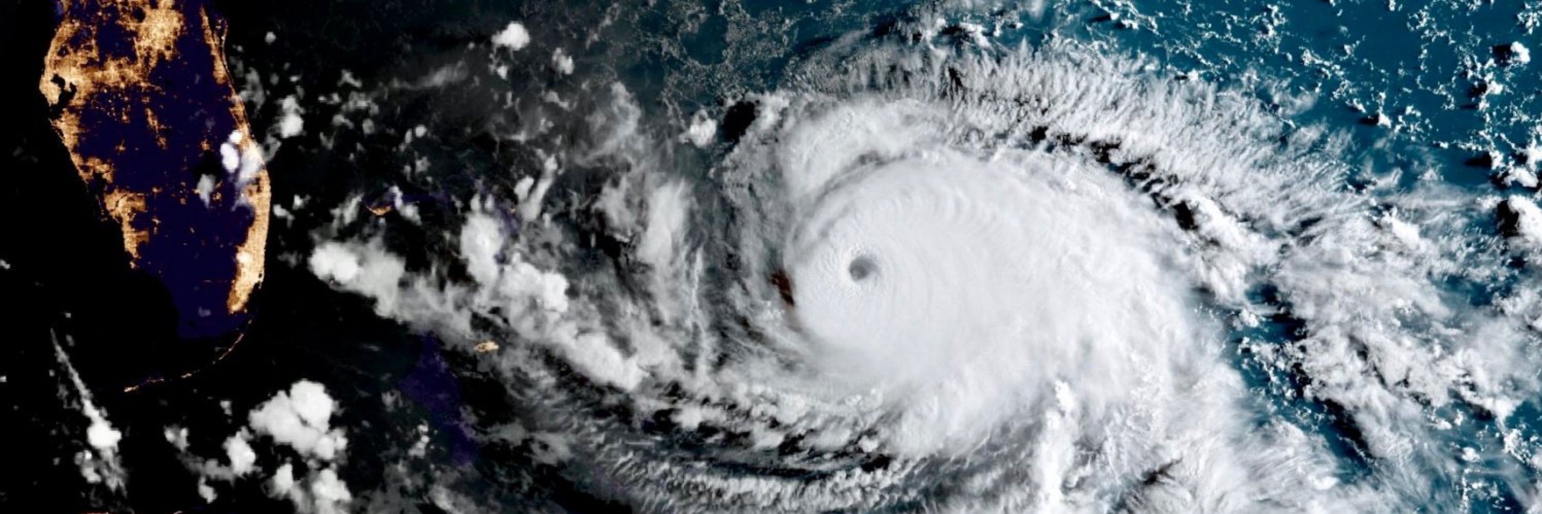
After a devastating landfall in Jamaica, Major Hurricane #Melissa has emerged north of the island. In a few hours it will strike again, this time in southern Cuba.
October 28, 2025 at 10:19 PM
After a devastating landfall in Jamaica, Major Hurricane #Melissa has emerged north of the island. In a few hours it will strike again, this time in southern Cuba.