


Zoom Earth
@zoom.earth
Interactive weather map and hurricane tracker.
Get our app 👉 https://zoom.earth/app
Get our app 👉 https://zoom.earth/app
Travel is NOT recommended this weekend 🛑
Major interstates (I-10, I-20, I-30, I-40, I-55, I-70, I-81, I-95) expected to have hazardous or impassable conditions.
Saturday looks to be the worst day. This is already happening. Prepare now and stay safe!
Major interstates (I-10, I-20, I-30, I-40, I-55, I-70, I-81, I-95) expected to have hazardous or impassable conditions.
Saturday looks to be the worst day. This is already happening. Prepare now and stay safe!
January 23, 2026 at 8:11 PM
Travel is NOT recommended this weekend 🛑
Major interstates (I-10, I-20, I-30, I-40, I-55, I-70, I-81, I-95) expected to have hazardous or impassable conditions.
Saturday looks to be the worst day. This is already happening. Prepare now and stay safe!
Major interstates (I-10, I-20, I-30, I-40, I-55, I-70, I-81, I-95) expected to have hazardous or impassable conditions.
Saturday looks to be the worst day. This is already happening. Prepare now and stay safe!
Heavy snow zones ❄️
Boston: 12-20+ inches expected.
Oklahoma/Arkansas: 5-12”.
NYC: 5-12”.
Ohio Valley/Mid-Atlantic: 6-12”.
Snow arrives Sunday in the Northeast. Peak rates of 2-3”/hour are possible in some areas.
Boston: 12-20+ inches expected.
Oklahoma/Arkansas: 5-12”.
NYC: 5-12”.
Ohio Valley/Mid-Atlantic: 6-12”.
Snow arrives Sunday in the Northeast. Peak rates of 2-3”/hour are possible in some areas.
January 23, 2026 at 8:11 PM
Heavy snow zones ❄️
Boston: 12-20+ inches expected.
Oklahoma/Arkansas: 5-12”.
NYC: 5-12”.
Ohio Valley/Mid-Atlantic: 6-12”.
Snow arrives Sunday in the Northeast. Peak rates of 2-3”/hour are possible in some areas.
Boston: 12-20+ inches expected.
Oklahoma/Arkansas: 5-12”.
NYC: 5-12”.
Ohio Valley/Mid-Atlantic: 6-12”.
Snow arrives Sunday in the Northeast. Peak rates of 2-3”/hour are possible in some areas.
Possibly catastrophic ice zones 🧊
Northern MS and NE LA: Up to 1 inch of ice expected, which could mean power grid failure for several days.
Dallas: 36 hours of freezing precipitation is forecast.
If you’re in the ice zone, it’s best to assume you may lose power 🪫
Northern MS and NE LA: Up to 1 inch of ice expected, which could mean power grid failure for several days.
Dallas: 36 hours of freezing precipitation is forecast.
If you’re in the ice zone, it’s best to assume you may lose power 🪫
January 23, 2026 at 8:11 PM
Possibly catastrophic ice zones 🧊
Northern MS and NE LA: Up to 1 inch of ice expected, which could mean power grid failure for several days.
Dallas: 36 hours of freezing precipitation is forecast.
If you’re in the ice zone, it’s best to assume you may lose power 🪫
Northern MS and NE LA: Up to 1 inch of ice expected, which could mean power grid failure for several days.
Dallas: 36 hours of freezing precipitation is forecast.
If you’re in the ice zone, it’s best to assume you may lose power 🪫
Expect extreme cold 🥶
Wind chills: -40 to -50°F in Northern Plains with life-threatening exposure possible within minutes. Single digits expected from Texas to Carolinas by Monday.
Wind chills: -40 to -50°F in Northern Plains with life-threatening exposure possible within minutes. Single digits expected from Texas to Carolinas by Monday.
January 23, 2026 at 8:11 PM
Expect extreme cold 🥶
Wind chills: -40 to -50°F in Northern Plains with life-threatening exposure possible within minutes. Single digits expected from Texas to Carolinas by Monday.
Wind chills: -40 to -50°F in Northern Plains with life-threatening exposure possible within minutes. Single digits expected from Texas to Carolinas by Monday.
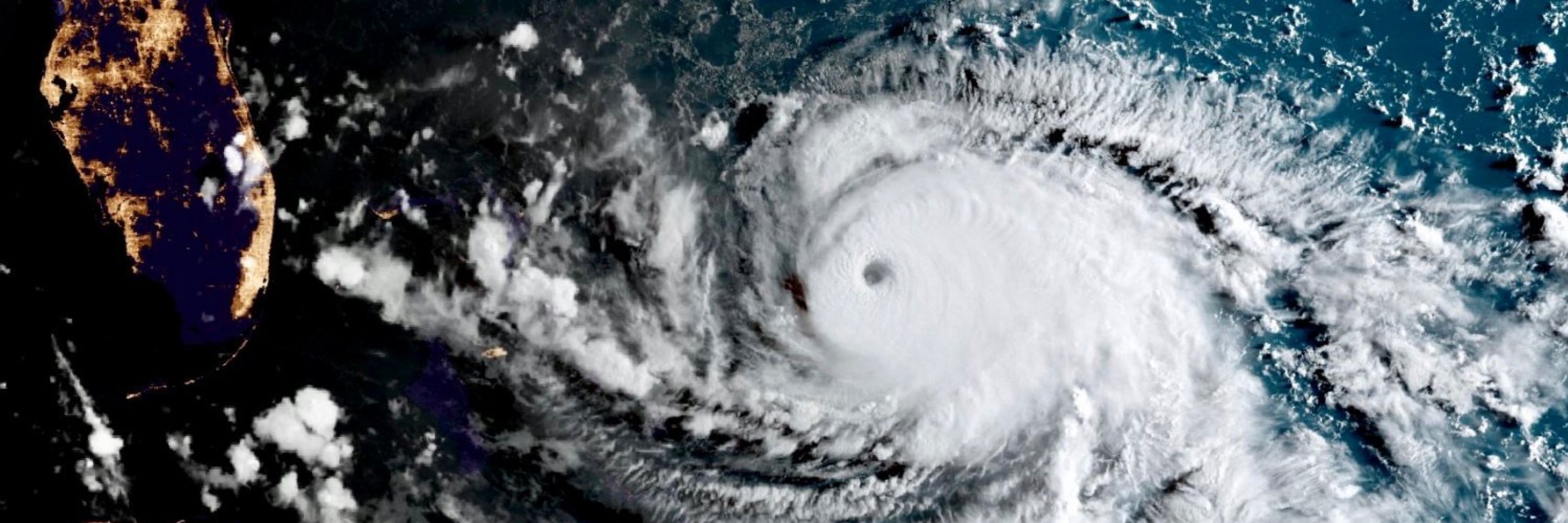
Wind maps are only a forecast model. Radar and satellite are observations and are much better suited to tracking the exact central location of the eye
November 22, 2025 at 9:04 AM
Wind maps are only a forecast model. Radar and satellite are observations and are much better suited to tracking the exact central location of the eye
Yes let’s hope the fix sticks!

November 18, 2025 at 2:44 PM
Yes let’s hope the fix sticks!
It's very intermittent, but yes, it's slowly coming back now
November 18, 2025 at 12:57 PM
It's very intermittent, but yes, it's slowly coming back now
Uwan live tracker here: zoom.earth/storms/fung-...

Typhoon Fung-wong (Uwan) LIVE Tracker, Updates & Forecast | Zoom Earth
Live tracking map, satellite, radar, and forecasts of Typhoon Fung-wong 2025 (台風26号) east of Luzon in the Philippines. Current wind speed 205km/h.
zoom.earth
November 8, 2025 at 11:48 PM
Uwan live tracker here: zoom.earth/storms/fung-...
Correction: Late Sunday into Monday, not late Monday.
November 7, 2025 at 11:46 PM
Correction: Late Sunday into Monday, not late Monday.
Typhoon Uwan latest track update here: zoom.earth/storms/fung-...

Typhoon Fung-wong (Uwan) LIVE Tracker, Updates & Forecast | Zoom Earth
Live tracking map, satellite, radar, and forecasts of Typhoon Fung-wong 2025 (台風26号) in the Philippine Sea. Current wind speed 130km/h. Max 215km/h.
zoom.earth
November 7, 2025 at 10:17 PM
Typhoon Uwan latest track update here: zoom.earth/storms/fung-...