


Jonathan Erdman
@wxjerdman.bsky.social
Senior meteorologist @weatherchannel. M.S. Colorado State Univ.; B.S. UW-Madison; Insightful. Interesting. Impactful. Weather. Opinions are mine only, not of my employer.
57˚ may not sound all that cold to many of you.
But that was this morning's low in Key West, Florida, tying their "record coldest so early in fall" with four other dates in 1966, 1955, 1913.
But that was this morning's low in Key West, Florida, tying their "record coldest so early in fall" with four other dates in 1966, 1955, 1913.

November 11, 2025 at 3:28 PM
57˚ may not sound all that cold to many of you.
But that was this morning's low in Key West, Florida, tying their "record coldest so early in fall" with four other dates in 1966, 1955, 1913.
But that was this morning's low in Key West, Florida, tying their "record coldest so early in fall" with four other dates in 1966, 1955, 1913.
2 most intriguing weather games this weekend:
- #9 Oregon @ #20 Iowa: Weather only a "duck" could love.
- NY Giants @ Chicago Bears: A passing, kicking challenge with cold wind howling from end zone to end zone. Flurry or snow shower, too?
- #9 Oregon @ #20 Iowa: Weather only a "duck" could love.
- NY Giants @ Chicago Bears: A passing, kicking challenge with cold wind howling from end zone to end zone. Flurry or snow shower, too?


November 7, 2025 at 11:46 AM
2 most intriguing weather games this weekend:
- #9 Oregon @ #20 Iowa: Weather only a "duck" could love.
- NY Giants @ Chicago Bears: A passing, kicking challenge with cold wind howling from end zone to end zone. Flurry or snow shower, too?
- #9 Oregon @ #20 Iowa: Weather only a "duck" could love.
- NY Giants @ Chicago Bears: A passing, kicking challenge with cold wind howling from end zone to end zone. Flurry or snow shower, too?
This may be the coldest early November outbreak in parts of Florida and the Southeast since 1993.
About 2 dozen daily record lows in jeopardy on Veterans Day.
More deets: weather.com/forecast/reg...
About 2 dozen daily record lows in jeopardy on Veterans Day.
More deets: weather.com/forecast/reg...

November 7, 2025 at 10:42 AM
This may be the coldest early November outbreak in parts of Florida and the Southeast since 1993.
About 2 dozen daily record lows in jeopardy on Veterans Day.
More deets: weather.com/forecast/reg...
About 2 dozen daily record lows in jeopardy on Veterans Day.
More deets: weather.com/forecast/reg...
There's a good chance you've seen this infamous video if you've taken any science, physics, or engineering class.
The Tacoma Narrows Bridge collapse happened 85 years ago today.
weather.com/science/weat...
The Tacoma Narrows Bridge collapse happened 85 years ago today.
weather.com/science/weat...

November 7, 2025 at 10:34 AM
There's a good chance you've seen this infamous video if you've taken any science, physics, or engineering class.
The Tacoma Narrows Bridge collapse happened 85 years ago today.
weather.com/science/weat...
The Tacoma Narrows Bridge collapse happened 85 years ago today.
weather.com/science/weat...
Last night: Nov. record setting Atlantic Canada "bomb cyclone", very nearly an all-time record low pressure for Newfoundland.
Now: Pacific storm moving ashore right now with high winds.
Late today-early Thu: Locally damaging winds possible in the Northeast.
#November 🌬️🍃
Now: Pacific storm moving ashore right now with high winds.
Late today-early Thu: Locally damaging winds possible in the Northeast.
#November 🌬️🍃


November 5, 2025 at 11:37 AM
Last night: Nov. record setting Atlantic Canada "bomb cyclone", very nearly an all-time record low pressure for Newfoundland.
Now: Pacific storm moving ashore right now with high winds.
Late today-early Thu: Locally damaging winds possible in the Northeast.
#November 🌬️🍃
Now: Pacific storm moving ashore right now with high winds.
Late today-early Thu: Locally damaging winds possible in the Northeast.
#November 🌬️🍃
Starting to see a few daily record lows and cold highs entering into play in the Southeast early next week.
How about daytime highs struggling to reach the low 50s along the coast of the Carolinas Tuesday?
Fortunately, this cold won't last long.
How about daytime highs struggling to reach the low 50s along the coast of the Carolinas Tuesday?
Fortunately, this cold won't last long.


November 5, 2025 at 11:19 AM
Starting to see a few daily record lows and cold highs entering into play in the Southeast early next week.
How about daytime highs struggling to reach the low 50s along the coast of the Carolinas Tuesday?
Fortunately, this cold won't last long.
How about daytime highs struggling to reach the low 50s along the coast of the Carolinas Tuesday?
Fortunately, this cold won't last long.
Here are all the Category 5 segments of the 45 known Cat 5 Atlantic Basin hurricanes since 1924, with Melissa's 36-hour segment highlighted.

October 29, 2025 at 10:13 AM
Here are all the Category 5 segments of the 45 known Cat 5 Atlantic Basin hurricanes since 1924, with Melissa's 36-hour segment highlighted.
While Melissa carves through eastern Cuba, bands of heavy rain are *still* soaking Haiti.
I believe a post from @drmetwatch.bsky.social Tuesday would imply that today is day 8 of at least locally heavy rain in Hispaniola.
E flank outer bands of TCs are frequently signif. flash flood generators.
I believe a post from @drmetwatch.bsky.social Tuesday would imply that today is day 8 of at least locally heavy rain in Hispaniola.
E flank outer bands of TCs are frequently signif. flash flood generators.

October 29, 2025 at 9:08 AM
While Melissa carves through eastern Cuba, bands of heavy rain are *still* soaking Haiti.
I believe a post from @drmetwatch.bsky.social Tuesday would imply that today is day 8 of at least locally heavy rain in Hispaniola.
E flank outer bands of TCs are frequently signif. flash flood generators.
I believe a post from @drmetwatch.bsky.social Tuesday would imply that today is day 8 of at least locally heavy rain in Hispaniola.
E flank outer bands of TCs are frequently signif. flash flood generators.
A graphic that will live in infamy. 😥
Record tying intense Atlantic Basin hurricane landfall.
Record tying intense Atlantic Basin hurricane landfall.

October 28, 2025 at 5:15 PM
A graphic that will live in infamy. 😥
Record tying intense Atlantic Basin hurricane landfall.
Record tying intense Atlantic Basin hurricane landfall.
Concerned for the area around Black River, Jamaica for surge flooding, apart from catastrophic wind, rainfall flood impacts.
SLOSH, wind wave model combination suggests over 6 feet of above ground inundation or higher possible in areas shaded in orange and red.
SLOSH, wind wave model combination suggests over 6 feet of above ground inundation or higher possible in areas shaded in orange and red.

October 28, 2025 at 3:33 PM
Concerned for the area around Black River, Jamaica for surge flooding, apart from catastrophic wind, rainfall flood impacts.
SLOSH, wind wave model combination suggests over 6 feet of above ground inundation or higher possible in areas shaded in orange and red.
SLOSH, wind wave model combination suggests over 6 feet of above ground inundation or higher possible in areas shaded in orange and red.
A bit "apples and oranges" as tornado winds are almost always estimated from damage and hurricane winds can last much longer...
...but these peak sustained winds in Melissa are in the EF4 range. Some gusts could be EF5 in the hills/mountains, etc.
...but these peak sustained winds in Melissa are in the EF4 range. Some gusts could be EF5 in the hills/mountains, etc.

October 28, 2025 at 2:28 PM
A bit "apples and oranges" as tornado winds are almost always estimated from damage and hurricane winds can last much longer...
...but these peak sustained winds in Melissa are in the EF4 range. Some gusts could be EF5 in the hills/mountains, etc.
...but these peak sustained winds in Melissa are in the EF4 range. Some gusts could be EF5 in the hills/mountains, etc.
While most attention is rightfully on Jamaica with Cat. 5 Melissa...note also the trailing bands of heavy rain pumping into southwestern Haiti's Tiburon Peninsula.
Likely rainfall rates of several inches per hour into an extremely flash flood, mudslide prone area.
Likely rainfall rates of several inches per hour into an extremely flash flood, mudslide prone area.

October 28, 2025 at 11:42 AM
While most attention is rightfully on Jamaica with Cat. 5 Melissa...note also the trailing bands of heavy rain pumping into southwestern Haiti's Tiburon Peninsula.
Likely rainfall rates of several inches per hour into an extremely flash flood, mudslide prone area.
Likely rainfall rates of several inches per hour into an extremely flash flood, mudslide prone area.
Minor correction....I forgot Irma made *four* separate Cat. 5 landfalls, so added that landfall at St. Martin.

October 28, 2025 at 10:36 AM
Minor correction....I forgot Irma made *four* separate Cat. 5 landfalls, so added that landfall at St. Martin.
Melissa is forecast to be the Atlantic Basin's first Category 5 landfall today since Dorian on Sept. 1, 2019.
Quite an elite list of Cat. 5 Atlantic landfalls. Melissa will be among them by both pressure and winds.
Quite an elite list of Cat. 5 Atlantic landfalls. Melissa will be among them by both pressure and winds.

October 28, 2025 at 9:26 AM
Melissa is forecast to be the Atlantic Basin's first Category 5 landfall today since Dorian on Sept. 1, 2019.
Quite an elite list of Cat. 5 Atlantic landfalls. Melissa will be among them by both pressure and winds.
Quite an elite list of Cat. 5 Atlantic landfalls. Melissa will be among them by both pressure and winds.
Melissa's peak winds could "weaken slightly" before landfall. That could happen if it replaces its eyewall in an "eyewall replacement cycle".
But that would make Melissa's wind field *larger*, even while its peak winds tick down a tad.
That's what happened when Maria hit Puerto Rico in 2017.
But that would make Melissa's wind field *larger*, even while its peak winds tick down a tad.
That's what happened when Maria hit Puerto Rico in 2017.

October 27, 2025 at 12:50 PM
Melissa's peak winds could "weaken slightly" before landfall. That could happen if it replaces its eyewall in an "eyewall replacement cycle".
But that would make Melissa's wind field *larger*, even while its peak winds tick down a tad.
That's what happened when Maria hit Puerto Rico in 2017.
But that would make Melissa's wind field *larger*, even while its peak winds tick down a tad.
That's what happened when Maria hit Puerto Rico in 2017.
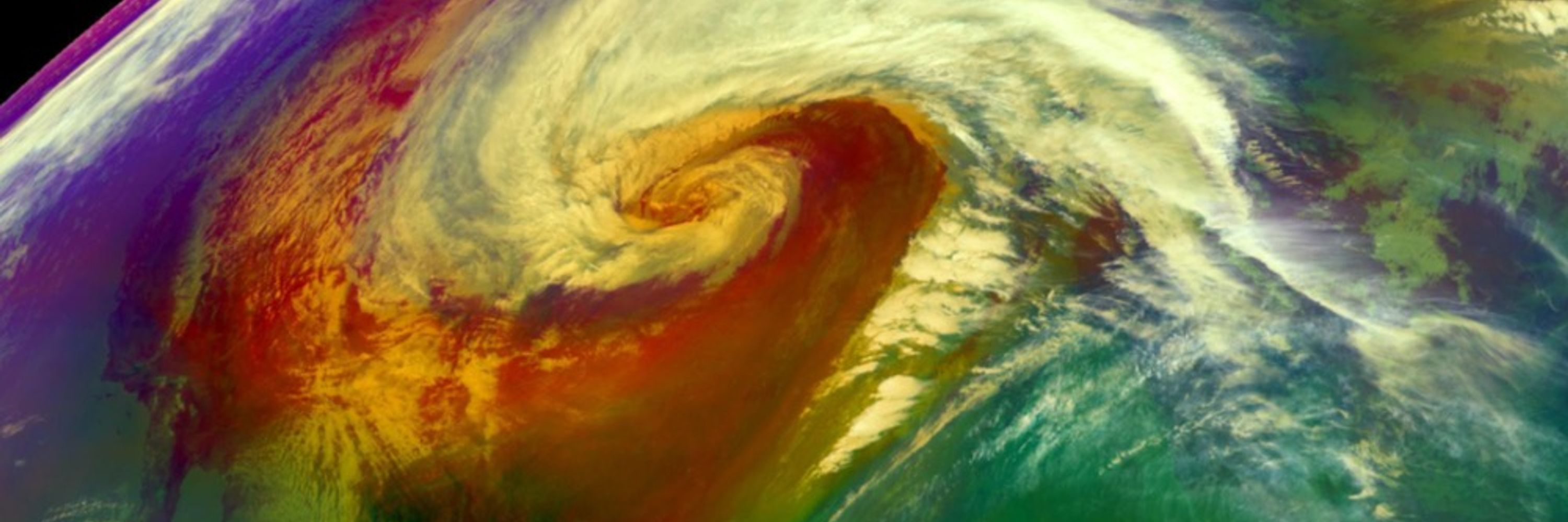
Classic eye of an intense hurricane sampled by the Hurricane Hunters thius morning.
Pressure plunge, double spike wind max passing through both eyewalls, temperature spike in eye.
Pressure plunge, double spike wind max passing through both eyewalls, temperature spike in eye.

October 27, 2025 at 11:42 AM
Classic eye of an intense hurricane sampled by the Hurricane Hunters thius morning.
Pressure plunge, double spike wind max passing through both eyewalls, temperature spike in eye.
Pressure plunge, double spike wind max passing through both eyewalls, temperature spike in eye.
Here are the only 2 previous Cat 5 hurricanes that passed within 70 miles of Jamaica in NOAA's database.
Neither made landfall, there.
Regardless of Cat 4 or 5, Melissa will, unfortunately, make history.
Neither made landfall, there.
Regardless of Cat 4 or 5, Melissa will, unfortunately, make history.

October 27, 2025 at 9:59 AM
Here are the only 2 previous Cat 5 hurricanes that passed within 70 miles of Jamaica in NOAA's database.
Neither made landfall, there.
Regardless of Cat 4 or 5, Melissa will, unfortunately, make history.
Neither made landfall, there.
Regardless of Cat 4 or 5, Melissa will, unfortunately, make history.
Only 8 Cat. 4 or 5 hurricanes have tracked within 60 nautical miles of Jamaica in ~175 years of NOAA records.
Melissa could be the first to make landfall, there, as a Cat 4 or 5. (Gilbert '88 appeared to have done so as Cat. 3)
History in the making, unfortunately.
Melissa could be the first to make landfall, there, as a Cat 4 or 5. (Gilbert '88 appeared to have done so as Cat. 3)
History in the making, unfortunately.

October 26, 2025 at 2:50 AM
Only 8 Cat. 4 or 5 hurricanes have tracked within 60 nautical miles of Jamaica in ~175 years of NOAA records.
Melissa could be the first to make landfall, there, as a Cat 4 or 5. (Gilbert '88 appeared to have done so as Cat. 3)
History in the making, unfortunately.
Melissa could be the first to make landfall, there, as a Cat 4 or 5. (Gilbert '88 appeared to have done so as Cat. 3)
History in the making, unfortunately.
Unsettling forecast for Jamaica, regardless of these 2 scenarios in a potential 3-5 day long lashing:
1. Hugs closer, winds less intense (land interaction), but torrential rain, winds.
2. Drifts south, becomes stronger hurricane before striking next week, with outer rainbands for days ahead.
1. Hugs closer, winds less intense (land interaction), but torrential rain, winds.
2. Drifts south, becomes stronger hurricane before striking next week, with outer rainbands for days ahead.


October 24, 2025 at 10:27 AM
Unsettling forecast for Jamaica, regardless of these 2 scenarios in a potential 3-5 day long lashing:
1. Hugs closer, winds less intense (land interaction), but torrential rain, winds.
2. Drifts south, becomes stronger hurricane before striking next week, with outer rainbands for days ahead.
1. Hugs closer, winds less intense (land interaction), but torrential rain, winds.
2. Drifts south, becomes stronger hurricane before striking next week, with outer rainbands for days ahead.
Found an observation reporting some wet snow flurries this AM in the beautiful northwoods of Woodruff, WI.

October 23, 2025 at 11:49 AM
Found an observation reporting some wet snow flurries this AM in the beautiful northwoods of Woodruff, WI.
With all the usual caveats, asterisks & disclaimers about forecasts 7 days out...
...could be an interesting East Coast system about this time next week. 🤔
...could be an interesting East Coast system about this time next week. 🤔


October 23, 2025 at 9:59 AM
With all the usual caveats, asterisks & disclaimers about forecasts 7 days out...
...could be an interesting East Coast system about this time next week. 🤔
...could be an interesting East Coast system about this time next week. 🤔
Marked reduction in shear by Friday.
Typically large W. Caribbean ocean heat content.
Lack of any dry air.
Think we'll have a much different looking Melissa by this weekend.
(Graphic kudos: @burgwx.bsky.social)
Typically large W. Caribbean ocean heat content.
Lack of any dry air.
Think we'll have a much different looking Melissa by this weekend.
(Graphic kudos: @burgwx.bsky.social)

October 22, 2025 at 3:14 PM
Marked reduction in shear by Friday.
Typically large W. Caribbean ocean heat content.
Lack of any dry air.
Think we'll have a much different looking Melissa by this weekend.
(Graphic kudos: @burgwx.bsky.social)
Typically large W. Caribbean ocean heat content.
Lack of any dry air.
Think we'll have a much different looking Melissa by this weekend.
(Graphic kudos: @burgwx.bsky.social)
Getting flashbacks to Dorian, seeing this paltry forward speed from Melissa.
Dorian did that while at Cat 5 intensity over the northwest Bahamas in one of the worst possible stalls (Harvey 2017 has its hand raised, too).
Dorian did that while at Cat 5 intensity over the northwest Bahamas in one of the worst possible stalls (Harvey 2017 has its hand raised, too).

October 22, 2025 at 12:00 PM
Getting flashbacks to Dorian, seeing this paltry forward speed from Melissa.
Dorian did that while at Cat 5 intensity over the northwest Bahamas in one of the worst possible stalls (Harvey 2017 has its hand raised, too).
Dorian did that while at Cat 5 intensity over the northwest Bahamas in one of the worst possible stalls (Harvey 2017 has its hand raised, too).
Hard to believe we're at the halfway point of "meteorological fall".
Here are the temp & precip season-to-date rankings from SERCC.
One of warmest falls to date in N. Plains, Northwest, Texas. One of driest falls in Great Lakes, Southeast.
Here are the temp & precip season-to-date rankings from SERCC.
One of warmest falls to date in N. Plains, Northwest, Texas. One of driest falls in Great Lakes, Southeast.


October 17, 2025 at 12:33 PM
Hard to believe we're at the halfway point of "meteorological fall".
Here are the temp & precip season-to-date rankings from SERCC.
One of warmest falls to date in N. Plains, Northwest, Texas. One of driest falls in Great Lakes, Southeast.
Here are the temp & precip season-to-date rankings from SERCC.
One of warmest falls to date in N. Plains, Northwest, Texas. One of driest falls in Great Lakes, Southeast.
I've always loved looking at maps.
Occasionally, I notice an island on our graphics software I've never seen before.
Today, I learned about the Swan Islands, apparently only occupied by a Honduran naval garrison.
These islands must have taken some pummeling from hurrricanes over the years.
Occasionally, I notice an island on our graphics software I've never seen before.
Today, I learned about the Swan Islands, apparently only occupied by a Honduran naval garrison.
These islands must have taken some pummeling from hurrricanes over the years.

October 16, 2025 at 12:41 PM
I've always loved looking at maps.
Occasionally, I notice an island on our graphics software I've never seen before.
Today, I learned about the Swan Islands, apparently only occupied by a Honduran naval garrison.
These islands must have taken some pummeling from hurrricanes over the years.
Occasionally, I notice an island on our graphics software I've never seen before.
Today, I learned about the Swan Islands, apparently only occupied by a Honduran naval garrison.
These islands must have taken some pummeling from hurrricanes over the years.