


WeatherTiger
@weathertiger.bsky.social
Daily tropical newsletter at weathertiger.substack.com. Posts by Dr. Ryan Truchelut, weatherman, inframarathoner, dad, dad-humorist.
As I laid out yesterday, this is a cataclysmic wind, surge, and flood event for Jamaica. I will have an update this afternoon on how landfall played out, but for now, please keep Jamaica in your thoughts and prayers. They need them.
October 28, 2025 at 1:11 PM
As I laid out yesterday, this is a cataclysmic wind, surge, and flood event for Jamaica. I will have an update this afternoon on how landfall played out, but for now, please keep Jamaica in your thoughts and prayers. They need them.
Thanks for reading and here's hoping that the luck of the 1st half of hurricane season can last through the 2nd half. After a record 10 major hurricanes in 9 yrs we need a break on the Gulf Coast.
Check out my full analysis of late-season landfall risks here:
Check out my full analysis of late-season landfall risks here:

Stolen Thunder: Hurricane Watch Weekly Column for September 10th
Hurricane season has fallen. Can it get up? We develop a new model to address that question.
weathertiger.substack.com
September 11, 2025 at 5:31 PM
Thanks for reading and here's hoping that the luck of the 1st half of hurricane season can last through the 2nd half. After a record 10 major hurricanes in 9 yrs we need a break on the Gulf Coast.
Check out my full analysis of late-season landfall risks here:
Check out my full analysis of late-season landfall risks here:
So, the war between favorable ocean & hostile atmospheric conditions may persist in the final third of hurricane season and U.S. landfall risks.
WeatherTiger's model of post-9/20 Gulf/W. Carib tropical activity is a bit above normal but not nearly as busy as 2020/24 late seasons.
WeatherTiger's model of post-9/20 Gulf/W. Carib tropical activity is a bit above normal but not nearly as busy as 2020/24 late seasons.

September 11, 2025 at 5:31 PM
So, the war between favorable ocean & hostile atmospheric conditions may persist in the final third of hurricane season and U.S. landfall risks.
WeatherTiger's model of post-9/20 Gulf/W. Carib tropical activity is a bit above normal but not nearly as busy as 2020/24 late seasons.
WeatherTiger's model of post-9/20 Gulf/W. Carib tropical activity is a bit above normal but not nearly as busy as 2020/24 late seasons.
The 2nd key predictor of post-9/20 Gulf/W. Carib activity is September ridging over the SE United States. More Sept. ridging is correlated with more hurricane activity.
Sept. 2025 has been the exact opposite of this pattern so far: persistent deep troughing over the eastern U.S.
Sept. 2025 has been the exact opposite of this pattern so far: persistent deep troughing over the eastern U.S.


September 11, 2025 at 5:31 PM
The 2nd key predictor of post-9/20 Gulf/W. Carib activity is September ridging over the SE United States. More Sept. ridging is correlated with more hurricane activity.
Sept. 2025 has been the exact opposite of this pattern so far: persistent deep troughing over the eastern U.S.
Sept. 2025 has been the exact opposite of this pattern so far: persistent deep troughing over the eastern U.S.


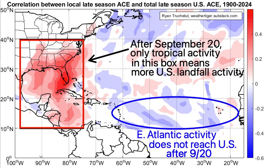
Only Gulf & W. Caribbean (west of 75W) activity post-9/20 translates to more late season U.S. landfalls.
SSTs are 1 key predictor of late season Gulf/Carib storms. More activity is linked to warm Caribbean/C. Atlantic, colder Pacific/Nina conditions. Sept. 2025 resembles that.
SSTs are 1 key predictor of late season Gulf/Carib storms. More activity is linked to warm Caribbean/C. Atlantic, colder Pacific/Nina conditions. Sept. 2025 resembles that.
September 11, 2025 at 5:31 PM
Only Gulf & W. Caribbean (west of 75W) activity post-9/20 translates to more late season U.S. landfalls.
SSTs are 1 key predictor of late season Gulf/Carib storms. More activity is linked to warm Caribbean/C. Atlantic, colder Pacific/Nina conditions. Sept. 2025 resembles that.
SSTs are 1 key predictor of late season Gulf/Carib storms. More activity is linked to warm Caribbean/C. Atlantic, colder Pacific/Nina conditions. Sept. 2025 resembles that.
Conditions in the east Atlantic may become more conducive for waves to develop in the next week.
But that may not translate to U.S. landfall risks. After 9/20, more hurricane activity east of the Lesser Antilles is actually linked to slightly fewer late-season U.S. landfalls.
But that may not translate to U.S. landfall risks. After 9/20, more hurricane activity east of the Lesser Antilles is actually linked to slightly fewer late-season U.S. landfalls.
September 11, 2025 at 5:31 PM
Conditions in the east Atlantic may become more conducive for waves to develop in the next week.
But that may not translate to U.S. landfall risks. After 9/20, more hurricane activity east of the Lesser Antilles is actually linked to slightly fewer late-season U.S. landfalls.
But that may not translate to U.S. landfall risks. After 9/20, more hurricane activity east of the Lesser Antilles is actually linked to slightly fewer late-season U.S. landfalls.
In short, nearly the entire Atlantic Basin has seen less convection (tstorms) than normal over the last month because of persistent sinking air aloft and mid-level dry air incursions.
Convection is the building block of tropical cyclones, so no convection, no hurricanes. 2/7
Convection is the building block of tropical cyclones, so no convection, no hurricanes. 2/7

September 11, 2025 at 5:31 PM
In short, nearly the entire Atlantic Basin has seen less convection (tstorms) than normal over the last month because of persistent sinking air aloft and mid-level dry air incursions.
Convection is the building block of tropical cyclones, so no convection, no hurricanes. 2/7
Convection is the building block of tropical cyclones, so no convection, no hurricanes. 2/7