


WeatherTiger
@weathertiger.bsky.social
Daily tropical newsletter at weathertiger.substack.com. Posts by Dr. Ryan Truchelut, weatherman, inframarathoner, dad, dad-humorist.
Hurricane season 2025 ends in less than a week.
The 2025 season has the distinction of having the lowest proportion of total Atlantic tropical activity (ACE) occurring near or over the continental U.S. of any year since 1950: a measly 0.2% versus a typical 4 to 5%.
The 2025 season has the distinction of having the lowest proportion of total Atlantic tropical activity (ACE) occurring near or over the continental U.S. of any year since 1950: a measly 0.2% versus a typical 4 to 5%.

November 25, 2025 at 7:49 PM
Hurricane season 2025 ends in less than a week.
The 2025 season has the distinction of having the lowest proportion of total Atlantic tropical activity (ACE) occurring near or over the continental U.S. of any year since 1950: a measly 0.2% versus a typical 4 to 5%.
The 2025 season has the distinction of having the lowest proportion of total Atlantic tropical activity (ACE) occurring near or over the continental U.S. of any year since 1950: a measly 0.2% versus a typical 4 to 5%.
As I laid out yesterday, this is a cataclysmic wind, surge, and flood event for Jamaica. I will have an update this afternoon on how landfall played out, but for now, please keep Jamaica in your thoughts and prayers. They need them.
October 28, 2025 at 1:11 PM
As I laid out yesterday, this is a cataclysmic wind, surge, and flood event for Jamaica. I will have an update this afternoon on how landfall played out, but for now, please keep Jamaica in your thoughts and prayers. They need them.
#Melissa is hours away from making landfall in west-central Jamaica and continues to intensify. Minimum pressure has dropped to 896 mb, which makes Melissa the 7th Atlantic hurricane on to breach 900 mb. Maximum sustained winds are estimated at 180 mph, tied for 6th-strongest ever in the Atlantic.


October 28, 2025 at 1:10 PM
#Melissa is hours away from making landfall in west-central Jamaica and continues to intensify. Minimum pressure has dropped to 896 mb, which makes Melissa the 7th Atlantic hurricane on to breach 900 mb. Maximum sustained winds are estimated at 180 mph, tied for 6th-strongest ever in the Atlantic.
Hurricane Hunters confirming #Melissa is 2025's third Category 5 #hurricane, with sustained winds of 160 mph. Unfortunately, little weakening is expected before #HurricaneMelissa reaches #Jamaica tomorrow morning & #Cuba Wednesday.
New forecast discussion out later this morning.
New forecast discussion out later this morning.


October 27, 2025 at 12:24 PM
Hurricane Hunters confirming #Melissa is 2025's third Category 5 #hurricane, with sustained winds of 160 mph. Unfortunately, little weakening is expected before #HurricaneMelissa reaches #Jamaica tomorrow morning & #Cuba Wednesday.
New forecast discussion out later this morning.
New forecast discussion out later this morning.
With the NHC predicting #TropicalStormMelissa to become a major #hurricane next week, it looks to do so further east than most late season Cat 3+ storms.
The western/west-central Caribbean, where #Melissa will be, are most common locations for rapid intensification in late October or November.
The western/west-central Caribbean, where #Melissa will be, are most common locations for rapid intensification in late October or November.

October 22, 2025 at 3:44 PM
With the NHC predicting #TropicalStormMelissa to become a major #hurricane next week, it looks to do so further east than most late season Cat 3+ storms.
The western/west-central Caribbean, where #Melissa will be, are most common locations for rapid intensification in late October or November.
The western/west-central Caribbean, where #Melissa will be, are most common locations for rapid intensification in late October or November.
TS #Humberto and #Invest94L continue to be features to watch closely. The bigger threat, Invest #94L, should follow a steering channel east of #Florida this weekend. #Carolinas have a higher chance of a direct landfall early next week.
Thursday update here: weathertiger.substack.com/p/dont-call-...
Thursday update here: weathertiger.substack.com/p/dont-call-...

September 25, 2025 at 5:59 PM
TS #Humberto and #Invest94L continue to be features to watch closely. The bigger threat, Invest #94L, should follow a steering channel east of #Florida this weekend. #Carolinas have a higher chance of a direct landfall early next week.
Thursday update here: weathertiger.substack.com/p/dont-call-...
Thursday update here: weathertiger.substack.com/p/dont-call-...
So, the war between favorable ocean & hostile atmospheric conditions may persist in the final third of hurricane season and U.S. landfall risks.
WeatherTiger's model of post-9/20 Gulf/W. Carib tropical activity is a bit above normal but not nearly as busy as 2020/24 late seasons.
WeatherTiger's model of post-9/20 Gulf/W. Carib tropical activity is a bit above normal but not nearly as busy as 2020/24 late seasons.

September 11, 2025 at 5:31 PM
So, the war between favorable ocean & hostile atmospheric conditions may persist in the final third of hurricane season and U.S. landfall risks.
WeatherTiger's model of post-9/20 Gulf/W. Carib tropical activity is a bit above normal but not nearly as busy as 2020/24 late seasons.
WeatherTiger's model of post-9/20 Gulf/W. Carib tropical activity is a bit above normal but not nearly as busy as 2020/24 late seasons.
The 2nd key predictor of post-9/20 Gulf/W. Carib activity is September ridging over the SE United States. More Sept. ridging is correlated with more hurricane activity.
Sept. 2025 has been the exact opposite of this pattern so far: persistent deep troughing over the eastern U.S.
Sept. 2025 has been the exact opposite of this pattern so far: persistent deep troughing over the eastern U.S.


September 11, 2025 at 5:31 PM
The 2nd key predictor of post-9/20 Gulf/W. Carib activity is September ridging over the SE United States. More Sept. ridging is correlated with more hurricane activity.
Sept. 2025 has been the exact opposite of this pattern so far: persistent deep troughing over the eastern U.S.
Sept. 2025 has been the exact opposite of this pattern so far: persistent deep troughing over the eastern U.S.


Conditions in the east Atlantic may become more conducive for waves to develop in the next week.
But that may not translate to U.S. landfall risks. After 9/20, more hurricane activity east of the Lesser Antilles is actually linked to slightly fewer late-season U.S. landfalls.
But that may not translate to U.S. landfall risks. After 9/20, more hurricane activity east of the Lesser Antilles is actually linked to slightly fewer late-season U.S. landfalls.
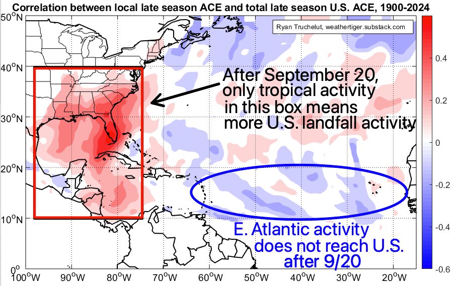
September 11, 2025 at 5:31 PM
Conditions in the east Atlantic may become more conducive for waves to develop in the next week.
But that may not translate to U.S. landfall risks. After 9/20, more hurricane activity east of the Lesser Antilles is actually linked to slightly fewer late-season U.S. landfalls.
But that may not translate to U.S. landfall risks. After 9/20, more hurricane activity east of the Lesser Antilles is actually linked to slightly fewer late-season U.S. landfalls.
In short, nearly the entire Atlantic Basin has seen less convection (tstorms) than normal over the last month because of persistent sinking air aloft and mid-level dry air incursions.
Convection is the building block of tropical cyclones, so no convection, no hurricanes. 2/7
Convection is the building block of tropical cyclones, so no convection, no hurricanes. 2/7

September 11, 2025 at 5:31 PM
In short, nearly the entire Atlantic Basin has seen less convection (tstorms) than normal over the last month because of persistent sinking air aloft and mid-level dry air incursions.
Convection is the building block of tropical cyclones, so no convection, no hurricanes. 2/7
Convection is the building block of tropical cyclones, so no convection, no hurricanes. 2/7
If you follow the Tropical Atlantic, you might be confused like our friend Vincent Vega here by the lack of any named storms since August 28th, a timeframe that is the climatological peak of #hurricane season.
So what's going on, and will it continue? Thread: (1/7)
So what's going on, and will it continue? Thread: (1/7)
September 11, 2025 at 5:31 PM
If you follow the Tropical Atlantic, you might be confused like our friend Vincent Vega here by the lack of any named storms since August 28th, a timeframe that is the climatological peak of #hurricane season.
So what's going on, and will it continue? Thread: (1/7)
So what's going on, and will it continue? Thread: (1/7)
[Annual post]
Convection crippled by the dry air that keeps on blowin'
Subsidence imposin'
And we
Keep bleeding, keep, keep bleeding ACE
And we keep bleeding, keep, keep bleeding ACE
Keep bleeding, keep, keep bleeding ACE
Shear cuts waves open
Convection crippled by the dry air that keeps on blowin'
Subsidence imposin'
And we
Keep bleeding, keep, keep bleeding ACE
And we keep bleeding, keep, keep bleeding ACE
Keep bleeding, keep, keep bleeding ACE
Shear cuts waves open
September 9, 2025 at 2:47 PM
[Annual post]
Convection crippled by the dry air that keeps on blowin'
Subsidence imposin'
And we
Keep bleeding, keep, keep bleeding ACE
And we keep bleeding, keep, keep bleeding ACE
Keep bleeding, keep, keep bleeding ACE
Shear cuts waves open
Convection crippled by the dry air that keeps on blowin'
Subsidence imposin'
And we
Keep bleeding, keep, keep bleeding ACE
And we keep bleeding, keep, keep bleeding ACE
Keep bleeding, keep, keep bleeding ACE
Shear cuts waves open
With Invest 91L succumbing to dry air and subsidence and no longer a threat to develop, here's a look at this morning's NHC Tropical Weather Outlook:

September 7, 2025 at 11:34 AM
With Invest 91L succumbing to dry air and subsidence and no longer a threat to develop, here's a look at this morning's NHC Tropical Weather Outlook:
Atlantic Tropical development is unlikely in the last week of August.
That's a little unusual: over the last 75 years, at least one tropical storm has formed ~60% of the time. At least one hurricane developed in ~40% of seasons.
Nice easy week. Cherish it while it lasts.
That's a little unusual: over the last 75 years, at least one tropical storm has formed ~60% of the time. At least one hurricane developed in ~40% of seasons.
Nice easy week. Cherish it while it lasts.

August 25, 2025 at 7:15 PM
Atlantic Tropical development is unlikely in the last week of August.
That's a little unusual: over the last 75 years, at least one tropical storm has formed ~60% of the time. At least one hurricane developed in ~40% of seasons.
Nice easy week. Cherish it while it lasts.
That's a little unusual: over the last 75 years, at least one tropical storm has formed ~60% of the time. At least one hurricane developed in ~40% of seasons.
Nice easy week. Cherish it while it lasts.
The scope of 2-2.5' surge today with #Erin is very impressive, spanning all the way from North Carolina to New Jersey despite a track 300+ miles offshore.
This evening's high tide will be the highest water for the mid-Atlantic, and moderate flood stage is possible in some locations. Be safe!
This evening's high tide will be the highest water for the mid-Atlantic, and moderate flood stage is possible in some locations. Be safe!

August 21, 2025 at 8:33 PM
The scope of 2-2.5' surge today with #Erin is very impressive, spanning all the way from North Carolina to New Jersey despite a track 300+ miles offshore.
This evening's high tide will be the highest water for the mid-Atlantic, and moderate flood stage is possible in some locations. Be safe!
This evening's high tide will be the highest water for the mid-Atlantic, and moderate flood stage is possible in some locations. Be safe!
With Category 4 #HurricaneErin ripping ~20 ACE units so far (and 15-20 ACE to go), the 2025 #HurricaneSeason has rapidly vaulted out of the climatological basement— moving up from <30th percentile to date last week to nearly 80th percentile today.
More percentile gains from #Erin to come.
More percentile gains from #Erin to come.


August 18, 2025 at 2:39 PM
With Category 4 #HurricaneErin ripping ~20 ACE units so far (and 15-20 ACE to go), the 2025 #HurricaneSeason has rapidly vaulted out of the climatological basement— moving up from <30th percentile to date last week to nearly 80th percentile today.
More percentile gains from #Erin to come.
More percentile gains from #Erin to come.
Despite chatter, odds are stacked against Tropical Storm Erin having U.S. impacts- just around 5% of historical storms near Erin's location later struck the U.S. coast.
Worth watching as #Erin will likely become the first major hurricane of 2025, but certainly no cause for alarm stateside.
Worth watching as #Erin will likely become the first major hurricane of 2025, but certainly no cause for alarm stateside.

August 11, 2025 at 4:26 PM
Despite chatter, odds are stacked against Tropical Storm Erin having U.S. impacts- just around 5% of historical storms near Erin's location later struck the U.S. coast.
Worth watching as #Erin will likely become the first major hurricane of 2025, but certainly no cause for alarm stateside.
Worth watching as #Erin will likely become the first major hurricane of 2025, but certainly no cause for alarm stateside.
Of course, 94% of historical ACE has occurred after this date, and the correlation between June/July ACE and August-November ACE is minimal, so that doesn't necessarily mean anything. Personally, I would be thrilled if the hurricane season remained sluggish throughout 2025, as would most in Florida.

July 25, 2025 at 12:22 PM
Of course, 94% of historical ACE has occurred after this date, and the correlation between June/July ACE and August-November ACE is minimal, so that doesn't necessarily mean anything. Personally, I would be thrilled if the hurricane season remained sluggish throughout 2025, as would most in Florida.
Named storms aren't a great way of assessing seasonal activity. Accumulated Cyclone Energy, accounting for both intensity and longevity of storms, is better.
Currently, 2025 is a 28th percentile season to date in terms of ACE, which I would call somewhat below average or even "a slow start."
Currently, 2025 is a 28th percentile season to date in terms of ACE, which I would call somewhat below average or even "a slow start."

July 25, 2025 at 12:19 PM
Named storms aren't a great way of assessing seasonal activity. Accumulated Cyclone Energy, accounting for both intensity and longevity of storms, is better.
Currently, 2025 is a 28th percentile season to date in terms of ACE, which I would call somewhat below average or even "a slow start."
Currently, 2025 is a 28th percentile season to date in terms of ACE, which I would call somewhat below average or even "a slow start."
NWS Excessive Rainfall Outlooks for the next 4 days show the flood risks shifting west with time.
Highest probability of flooding and heaviest accumulations are likely late Thursday into Saturday as #93L slows down and begins turning north into central Gulf Coast.
Highest probability of flooding and heaviest accumulations are likely late Thursday into Saturday as #93L slows down and begins turning north into central Gulf Coast.


July 15, 2025 at 4:04 PM
NWS Excessive Rainfall Outlooks for the next 4 days show the flood risks shifting west with time.
Highest probability of flooding and heaviest accumulations are likely late Thursday into Saturday as #93L slows down and begins turning north into central Gulf Coast.
Highest probability of flooding and heaviest accumulations are likely late Thursday into Saturday as #93L slows down and begins turning north into central Gulf Coast.

The NHC is starting advisories on Tropical Depression 2 in the extreme southern Gulf at 5 pm. Like Andrea, TD 2 will also be very weak and short-lived, with no impact on U.S. weather as it moves west into Mexico tomorrow.
If it reaches tropical storm intensity, #Barry is the next name on the list.
If it reaches tropical storm intensity, #Barry is the next name on the list.

June 28, 2025 at 8:35 PM
The NHC is starting advisories on Tropical Depression 2 in the extreme southern Gulf at 5 pm. Like Andrea, TD 2 will also be very weak and short-lived, with no impact on U.S. weather as it moves west into Mexico tomorrow.
If it reaches tropical storm intensity, #Barry is the next name on the list.
If it reaches tropical storm intensity, #Barry is the next name on the list.
Newly developed #TropicalStormAndrea is the farthest northeast named storm formation point on record for June since 1900. However, the development point will probably be adjusted southwest post-season.
#Andrea will be *very* short-lived and is no threat to any landmass.
#Andrea will be *very* short-lived and is no threat to any landmass.

June 24, 2025 at 2:26 PM
Newly developed #TropicalStormAndrea is the farthest northeast named storm formation point on record for June since 1900. However, the development point will probably be adjusted southwest post-season.
#Andrea will be *very* short-lived and is no threat to any landmass.
#Andrea will be *very* short-lived and is no threat to any landmass.