


Thomas Gratier
@thomasg77.bsky.social
Freelance SIG libres, OSM & OpenData /w JS & Python. Auteur livre OpenLayers. Pro Webgeodatavore
+ http://formation-openlayers.fr Coopère ouvre-boites
+ http://formation-openlayers.fr Coopère ouvre-boites
Reposted by Thomas Gratier

🌡️ Rares voire rarissimes en France au XXe siècle, les températures dépassant localement les 40 degrés sont devenues fréquentes depuis l’an 2000. Voici une carte animée localisant chaque année où les stations de Météo-France ont relevé ou dépassé 40 degrés (données au 17 août).
August 25, 2025 at 11:00 AM
🌡️ Rares voire rarissimes en France au XXe siècle, les températures dépassant localement les 40 degrés sont devenues fréquentes depuis l’an 2000. Voici une carte animée localisant chaque année où les stations de Météo-France ont relevé ou dépassé 40 degrés (données au 17 août).
Reposted by Thomas Gratier

🎥 Ne manquez pas la projection de QGIS IV en avant-première!
🪄 Réalisation: @geojulien.bsky.social
🤓 Relecture: Loïc Bartoletti Nicolas Godet Julien Cabieces @guilhemallaman.bsky.social Arnaud Vandecasteele
👉 geotribu.fr/articles/202...
#QGIS
🪄 Réalisation: @geojulien.bsky.social
🤓 Relecture: Loïc Bartoletti Nicolas Godet Julien Cabieces @guilhemallaman.bsky.social Arnaud Vandecasteele
👉 geotribu.fr/articles/202...
#QGIS

Testez QGIS 4 avant tout le monde - Geotribu
Essayez QGIS 4 en avant-première ! Comme tout logiciel, open source ou propriétaire, QGIS repose sur d'autres logiciels ou bibliothèques. Des dépendances dont la principale est Qt.
geotribu.fr
February 3, 2025 at 7:32 AM
🎥 Ne manquez pas la projection de QGIS IV en avant-première!
🪄 Réalisation: @geojulien.bsky.social
🤓 Relecture: Loïc Bartoletti Nicolas Godet Julien Cabieces @guilhemallaman.bsky.social Arnaud Vandecasteele
👉 geotribu.fr/articles/202...
#QGIS
🪄 Réalisation: @geojulien.bsky.social
🤓 Relecture: Loïc Bartoletti Nicolas Godet Julien Cabieces @guilhemallaman.bsky.social Arnaud Vandecasteele
👉 geotribu.fr/articles/202...
#QGIS
Reposted by Thomas Gratier

Jane Fonda à la Screen Actors Guild : "Ne vous y trompez pas, l'empathie n'est pas une faiblesse ou un truc woke. Et d'ailleurs, être woke signifie juste que vous en avez quelque chose à foutre des gens autour de vous." Cette dame est le fer de lance de la résistance à Hollywood et l'a toujours été.

February 24, 2025 at 12:09 PM
Jane Fonda à la Screen Actors Guild : "Ne vous y trompez pas, l'empathie n'est pas une faiblesse ou un truc woke. Et d'ailleurs, être woke signifie juste que vous en avez quelque chose à foutre des gens autour de vous." Cette dame est le fer de lance de la résistance à Hollywood et l'a toujours été.
Reposted by Thomas Gratier

Data Viz Project | Collection of data visualizations to get inspired and find the right type
datavizproject.com
datavizproject.com

Data Viz Project
Collection of data visualizations to get inspired and find the right type
datavizproject.com
February 6, 2025 at 11:11 AM
Data Viz Project | Collection of data visualizations to get inspired and find the right type
datavizproject.com
datavizproject.com
Reposted by Thomas Gratier

The PC is Dead: It's Time To Make Computing Personal Again
My new essay on how we lost control of personal computing to Internet surveillance, DRM, and extractive business models—and how we can launch the era of Personal Computer 2.0
www.vintagecomputing.com/index.php/ar...
My new essay on how we lost control of personal computing to Internet surveillance, DRM, and extractive business models—and how we can launch the era of Personal Computer 2.0
www.vintagecomputing.com/index.php/ar...

January 18, 2025 at 1:18 AM
The PC is Dead: It's Time To Make Computing Personal Again
My new essay on how we lost control of personal computing to Internet surveillance, DRM, and extractive business models—and how we can launch the era of Personal Computer 2.0
www.vintagecomputing.com/index.php/ar...
My new essay on how we lost control of personal computing to Internet surveillance, DRM, and extractive business models—and how we can launch the era of Personal Computer 2.0
www.vintagecomputing.com/index.php/ar...
Reposted by Thomas Gratier


Street View: A History
How imagery visualizing the scenes along routes came to be
worldbuilder.substack.com
January 15, 2025 at 9:45 PM
Reposted by Thomas Gratier

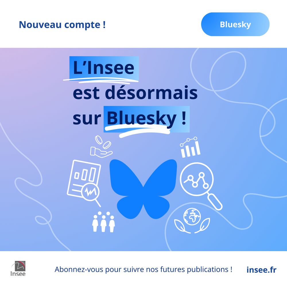
L’Insee est désormais sur Bluesky ! Dorénavant, vous pouvez également retrouver nos publications en suivant notre compte @insee.fr. Abonnez-vous !
February 26, 2025 at 11:28 AM
L’Insee est désormais sur Bluesky ! Dorénavant, vous pouvez également retrouver nos publications en suivant notre compte @insee.fr. Abonnez-vous !
Reposted by Thomas Gratier

State of the Art Python in 2024 #python
State of the Art Python in 2024 #python
This opinion piece shows which Python tools Anders thinks should be used when developing in Python.
4zm.org
February 18, 2025 at 5:00 PM
State of the Art Python in 2024 #python
Reposted by Thomas Gratier

Would love to see more individuals publish, maintain and collaborate on small datasets.
https://tomcritchlow.com/2023/01/27/small-databases/
https://tomcritchlow.com/2023/01/27/small-databases/

The Magic of Small Databases
Notes on personal libraries, collections and small indexes on the web
tomcritchlow.com
April 20, 2023 at 9:29 PM
Would love to see more individuals publish, maintain and collaborate on small datasets.
https://tomcritchlow.com/2023/01/27/small-databases/
https://tomcritchlow.com/2023/01/27/small-databases/
Reposted by Thomas Gratier
🗺🌍📹Le Plan Carte™ nouveau est arrivé !
Dedans, il y a :
- un mastodonte de la cartographie
- des frontières qui apparaissent et disparaissent
- une chanson absolument nécessaire
Comment Google redessine le monde ? @lesechosfr.bsky.social
www.youtube.com/watch?v=DRfi...
Dedans, il y a :
- un mastodonte de la cartographie
- des frontières qui apparaissent et disparaissent
- une chanson absolument nécessaire
Comment Google redessine le monde ? @lesechosfr.bsky.social
www.youtube.com/watch?v=DRfi...
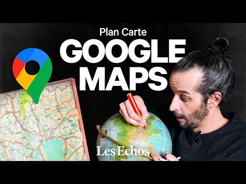
Comment Google Maps modifie le monde | Plan carte
YouTube video by Les Echos
www.youtube.com
February 9, 2025 at 5:24 PM
🗺🌍📹Le Plan Carte™ nouveau est arrivé !
Dedans, il y a :
- un mastodonte de la cartographie
- des frontières qui apparaissent et disparaissent
- une chanson absolument nécessaire
Comment Google redessine le monde ? @lesechosfr.bsky.social
www.youtube.com/watch?v=DRfi...
Dedans, il y a :
- un mastodonte de la cartographie
- des frontières qui apparaissent et disparaissent
- une chanson absolument nécessaire
Comment Google redessine le monde ? @lesechosfr.bsky.social
www.youtube.com/watch?v=DRfi...
Reprendre les "cartes" en main ! www.radiofrance.fr/franceinter/... #cartographie

Reprendre les "cartes" en main !
Dans les dix dernières minutes de La Terre au carré, La lutte enchantée de Camille Crosnier, la Une des médias avec Vincent Lucchese de Reporterre et vos messages laissés sur le répondeur de l'émissio...
www.radiofrance.fr
February 13, 2025 at 11:03 AM
Reprendre les "cartes" en main ! www.radiofrance.fr/franceinter/... #cartographie
Reposted by Thomas Gratier

It's time for #gischat !
How did you come to work in the geospatial industry or use geospatial tools? What drew you here? What was your journey to get here?
Remember to use the hashtag in your replies!
How did you come to work in the geospatial industry or use geospatial tools? What drew you here? What was your journey to get here?
Remember to use the hashtag in your replies!
January 22, 2025 at 6:00 PM
It's time for #gischat !
How did you come to work in the geospatial industry or use geospatial tools? What drew you here? What was your journey to get here?
Remember to use the hashtag in your replies!
How did you come to work in the geospatial industry or use geospatial tools? What drew you here? What was your journey to get here?
Remember to use the hashtag in your replies!
Reposted by Thomas Gratier


Reposted by Thomas Gratier
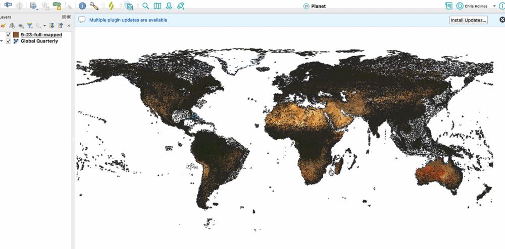
Pour afficher plus rapidement encore des couches cartographiques volumineuses avec le format #Geoparquet, pensez à les trier avec la fonction ST_Hilbert() de #DuckDB Spatial : cet article de @opencholmes.bsky.social l'explique de façon lumineuse.
cholmes.medium.com/using-duckdb...
cholmes.medium.com/using-duckdb...
Using DuckDB’s Hilbert Function with GeoP
DuckDB continues to be my go to tool for geospatial processing, after I discovered it over a year ago. Since that time its functionality…
cholmes.medium.com
January 16, 2025 at 11:00 AM
Pour afficher plus rapidement encore des couches cartographiques volumineuses avec le format #Geoparquet, pensez à les trier avec la fonction ST_Hilbert() de #DuckDB Spatial : cet article de @opencholmes.bsky.social l'explique de façon lumineuse.
cholmes.medium.com/using-duckdb...
cholmes.medium.com/using-duckdb...
Reposted by Thomas Gratier

Un peu de douceur (et d’intelligence) dans un monde de pétrole brut. #ConseilBD

January 16, 2025 at 8:43 AM
Un peu de douceur (et d’intelligence) dans un monde de pétrole brut. #ConseilBD
Reposted by Thomas Gratier

After a @Bellingcat workshop years ago, a participant built a geolocation tool to find locations that all had i.e. a library and a cafe in a 20m radius. Now, there's a supercharged version of that tool! Thanks @sanjanamv.bsky.social for flagging it. www.findthatspot.io

SPOT - the easy way to verify locations
Spot is a tool for finding combinations of objects in the public space world-wide.
www.findthatspot.io
January 13, 2025 at 4:55 PM
After a @Bellingcat workshop years ago, a participant built a geolocation tool to find locations that all had i.e. a library and a cafe in a 20m radius. Now, there's a supercharged version of that tool! Thanks @sanjanamv.bsky.social for flagging it. www.findthatspot.io
Reposted by Thomas Gratier
Just published in JOSS: 'antimeridian: A Python package for correcting geometries that cross the 180th meridian' https://doi.org/10.21105/joss.07530
January 8, 2025 at 8:54 PM
Just published in JOSS: 'antimeridian: A Python package for correcting geometries that cross the 180th meridian' https://doi.org/10.21105/joss.07530
Reposted by Thomas Gratier


January 8, 2025 at 9:23 PM
Reposted by Thomas Gratier

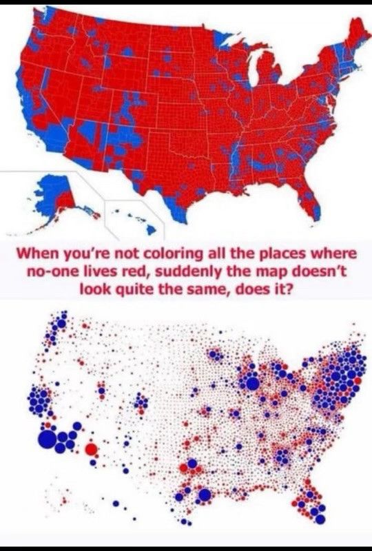
Land doesn’t vote. Stop pretending it does.
December 14, 2024 at 9:08 PM
Land doesn’t vote. Stop pretending it does.
Reposted by Thomas Gratier

I'm doing more & more research on the history of GPS and I'm amazed by the official US Gov's dedicated website for GPS: gps.gov
It's so old school it actually looks cool
And it ends up quite easy to navigate (would have been ironic otherwise)
It's so old school it actually looks cool
And it ends up quite easy to navigate (would have been ironic otherwise)

January 8, 2025 at 10:12 AM
I'm doing more & more research on the history of GPS and I'm amazed by the official US Gov's dedicated website for GPS: gps.gov
It's so old school it actually looks cool
And it ends up quite easy to navigate (would have been ironic otherwise)
It's so old school it actually looks cool
And it ends up quite easy to navigate (would have been ironic otherwise)
Reposted by Thomas Gratier

Avec l'abandon de toute politique de modération par Meta, Bluesky va mécaniquement accueillir du monde, donc attirer l'attention des trolls.
Pour garder ce site potable :
Do not engage.
Block.
Pour garder ce site potable :
Do not engage.
Block.
January 8, 2025 at 11:38 AM
Avec l'abandon de toute politique de modération par Meta, Bluesky va mécaniquement accueillir du monde, donc attirer l'attention des trolls.
Pour garder ce site potable :
Do not engage.
Block.
Pour garder ce site potable :
Do not engage.
Block.
Reposted by Thomas Gratier

.
La Quadrature du Net lance Attrap ("Automate de Traque de Termes et de Recherche dans les Arrêtés Préfectoraux").
CP : laquadrature.net/2024/12/19/c...
Attrap : attrap.fr
La Quadrature du Net lance Attrap ("Automate de Traque de Termes et de Recherche dans les Arrêtés Préfectoraux").
CP : laquadrature.net/2024/12/19/c...
Attrap : attrap.fr

December 19, 2024 at 2:22 PM
.
La Quadrature du Net lance Attrap ("Automate de Traque de Termes et de Recherche dans les Arrêtés Préfectoraux").
CP : laquadrature.net/2024/12/19/c...
Attrap : attrap.fr
La Quadrature du Net lance Attrap ("Automate de Traque de Termes et de Recherche dans les Arrêtés Préfectoraux").
CP : laquadrature.net/2024/12/19/c...
Attrap : attrap.fr
Reposted by Thomas Gratier

I am starting 2025 with a completely renewed blog based on Quarto. I have also updated all the previous posts. The first post addresses the issue of the lack of data normalization I observed in the Spanish National Atlas.
#rstats #dataviz
dominicroye.github.io/blog/2025-01...
#rstats #dataviz
dominicroye.github.io/blog/2025-01...

Always normalize you data
I recently came across a map from the National Atlas of Spain showing the number of libraries by municipality. However, one thing directly caught my attention. There’s a saying that many maps show onl...
dominicroye.github.io
January 6, 2025 at 10:35 AM
I am starting 2025 with a completely renewed blog based on Quarto. I have also updated all the previous posts. The first post addresses the issue of the lack of data normalization I observed in the Spanish National Atlas.
#rstats #dataviz
dominicroye.github.io/blog/2025-01...
#rstats #dataviz
dominicroye.github.io/blog/2025-01...

Reposted by Thomas Gratier

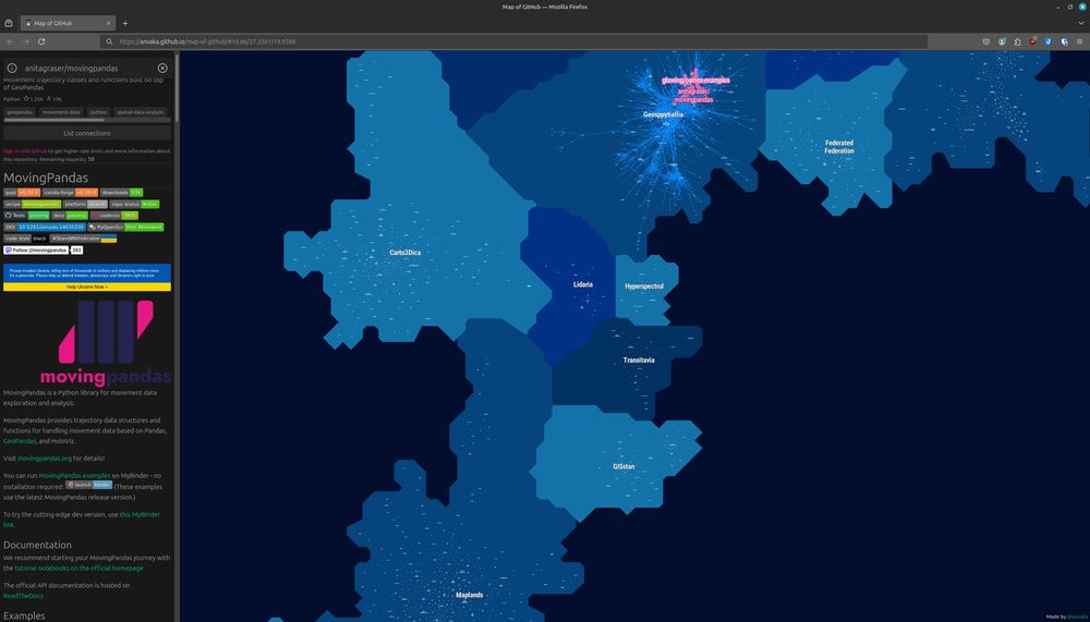
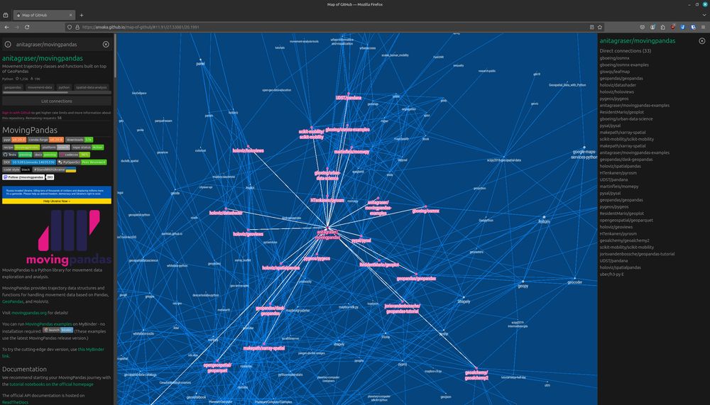
Interesting to see the distance between Maplands (home of
@qgis) and Geosppytiallia (home of @movingpandas) in #mapofgithub https://anvaka.github.io/map-of-github/#11.91/27.53081/20.1991
Why are Lidaria and Carto3Dica in between?
It's all #ai(Landia) 😜 […]
[Original post on fosstodon.org]
@qgis) and Geosppytiallia (home of @movingpandas) in #mapofgithub https://anvaka.github.io/map-of-github/#11.91/27.53081/20.1991
Why are Lidaria and Carto3Dica in between?
It's all #ai(Landia) 😜 […]
[Original post on fosstodon.org]
January 3, 2025 at 9:39 AM
Interesting to see the distance between Maplands (home of
@qgis) and Geosppytiallia (home of @movingpandas) in #mapofgithub https://anvaka.github.io/map-of-github/#11.91/27.53081/20.1991
Why are Lidaria and Carto3Dica in between?
It's all #ai(Landia) 😜 […]
[Original post on fosstodon.org]
@qgis) and Geosppytiallia (home of @movingpandas) in #mapofgithub https://anvaka.github.io/map-of-github/#11.91/27.53081/20.1991
Why are Lidaria and Carto3Dica in between?
It's all #ai(Landia) 😜 […]
[Original post on fosstodon.org]