


Stefan F. Keller
@sfkeller.bsky.social
Prof. Data Engineering and GISTech, FH OST Rapperswil. Director Institute for Software. Data Scout and Enabler - Formerly "Open Whatever"! mastodon.social/@sfkeller
Reposted by Stefan F. Keller
Habe die Slides für meine beiden Vorträge auf den Kieler Linux Tagen online gestellt:
andreas.scherbaum.la/writings/
Backups mit Restic und resticprofile
Füge Geokoordinaten zu deinen Adressen in PostgreSQL hinzu
#Backup #Restic #PostgreSQL #PostGIS #OSM #OpenStreetMap #Kiel #Kielux #Linux
andreas.scherbaum.la/writings/
Backups mit Restic und resticprofile
Füge Geokoordinaten zu deinen Adressen in PostgreSQL hinzu
#Backup #Restic #PostgreSQL #PostGIS #OSM #OpenStreetMap #Kiel #Kielux #Linux
Talks & Writings
a place to store my stuff
andreas.scherbaum.la
September 22, 2025 at 10:14 PM
Habe die Slides für meine beiden Vorträge auf den Kieler Linux Tagen online gestellt:
andreas.scherbaum.la/writings/
Backups mit Restic und resticprofile
Füge Geokoordinaten zu deinen Adressen in PostgreSQL hinzu
#Backup #Restic #PostgreSQL #PostGIS #OSM #OpenStreetMap #Kiel #Kielux #Linux
andreas.scherbaum.la/writings/
Backups mit Restic und resticprofile
Füge Geokoordinaten zu deinen Adressen in PostgreSQL hinzu
#Backup #Restic #PostgreSQL #PostGIS #OSM #OpenStreetMap #Kiel #Kielux #Linux
Reposted by Stefan F. Keller

September 3, 2025 at 6:00 AM
Reposted by Stefan F. Keller

TIL that #mapycom is more than just a renderer on top of #openstreetmap. They actually import buildings from #overture, which #osm doesn't consider reliable enough for automatic imports.
From what I've seen, the results are mixed in Greece, with many buildings that don't exist in reality.
From what I've seen, the results are mixed in Greece, with many buildings that don't exist in reality.
August 25, 2025 at 6:16 PM
TIL that #mapycom is more than just a renderer on top of #openstreetmap. They actually import buildings from #overture, which #osm doesn't consider reliable enough for automatic imports.
From what I've seen, the results are mixed in Greece, with many buildings that don't exist in reality.
From what I've seen, the results are mixed in Greece, with many buildings that don't exist in reality.
Reposted by Stefan F. Keller

Ever wondered why your company or favorite shop isn’t shown on many maps?
Because the marketing guy can’t think beyond google.
The good news: you can easily fix it yourself:
1. Create an #openstreetmap ( #OSM) account;
2. Improve the map at openstreetmap.org or (easier to start): mapcomplete.org
Because the marketing guy can’t think beyond google.
The good news: you can easily fix it yourself:
1. Create an #openstreetmap ( #OSM) account;
2. Improve the map at openstreetmap.org or (easier to start): mapcomplete.org

OpenStreetMap
OpenStreetMap is a map of the world, created by people like you and free to use under an open license.
openstreetmap.org
August 25, 2025 at 7:59 PM
Ever wondered why your company or favorite shop isn’t shown on many maps?
Because the marketing guy can’t think beyond google.
The good news: you can easily fix it yourself:
1. Create an #openstreetmap ( #OSM) account;
2. Improve the map at openstreetmap.org or (easier to start): mapcomplete.org
Because the marketing guy can’t think beyond google.
The good news: you can easily fix it yourself:
1. Create an #openstreetmap ( #OSM) account;
2. Improve the map at openstreetmap.org or (easier to start): mapcomplete.org
Reposted by Stefan F. Keller
This month #OpenStreetMap turns 21!
To mark the occasion, we dug into our archives to finish part 3 of Stamen's personal history of OSM, covering the years 2016 to the present. Check it out on our blog, including links to part 1 and 2 of the series:
stamen.com/part-3-our-b...
To mark the occasion, we dug into our archives to finish part 3 of Stamen's personal history of OSM, covering the years 2016 to the present. Check it out on our blog, including links to part 1 and 2 of the series:
stamen.com/part-3-our-b...


August 5, 2025 at 4:49 PM
This month #OpenStreetMap turns 21!
To mark the occasion, we dug into our archives to finish part 3 of Stamen's personal history of OSM, covering the years 2016 to the present. Check it out on our blog, including links to part 1 and 2 of the series:
stamen.com/part-3-our-b...
To mark the occasion, we dug into our archives to finish part 3 of Stamen's personal history of OSM, covering the years 2016 to the present. Check it out on our blog, including links to part 1 and 2 of the series:
stamen.com/part-3-our-b...
Reposted by Stefan F. Keller

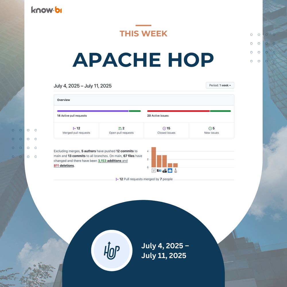
know.bi contributions to Apache Hop (July 4–11):
🔸 #Google Sheets proxy support
🔸 #Databricks support begins
🔸 Metrics + #Git doc updates
🔸 #XML Join improvements
@hop.apache.org
#apachehop #opensource #etl #databs #datasky
🔸 #Google Sheets proxy support
🔸 #Databricks support begins
🔸 Metrics + #Git doc updates
🔸 #XML Join improvements
@hop.apache.org
#apachehop #opensource #etl #databs #datasky
July 11, 2025 at 7:52 AM
know.bi contributions to Apache Hop (July 4–11):
🔸 #Google Sheets proxy support
🔸 #Databricks support begins
🔸 Metrics + #Git doc updates
🔸 #XML Join improvements
@hop.apache.org
#apachehop #opensource #etl #databs #datasky
🔸 #Google Sheets proxy support
🔸 #Databricks support begins
🔸 Metrics + #Git doc updates
🔸 #XML Join improvements
@hop.apache.org
#apachehop #opensource #etl #databs #datasky
Reposted by Stefan F. Keller

There's still to get your ticket for State of the Map 2025! @sotm
2025.stateofthemap.org/tickets/
#sotm2025 #OpenStreetMap
2025.stateofthemap.org/tickets/
#sotm2025 #OpenStreetMap

State of the Map 2025 – Manila
The global OpenStreetMap conference. 2025 in Manila & online.
2025.stateofthemap.org
August 5, 2025 at 5:49 PM
There's still to get your ticket for State of the Map 2025! @sotm
2025.stateofthemap.org/tickets/
#sotm2025 #OpenStreetMap
2025.stateofthemap.org/tickets/
#sotm2025 #OpenStreetMap
Reposted by Stefan F. Keller

🎉 NACIS 2025 Registration is Open! 🎉
Head over to nacis.org/annual-meeting/current-meeting to register at the member or student rate.
Not a member yet? You can join or register as a non-member too!
🕓Early-bird deadline: October 4
🏨Don’t forget to book your hotel too. Our room block fills up fast.
Head over to nacis.org/annual-meeting/current-meeting to register at the member or student rate.
Not a member yet? You can join or register as a non-member too!
🕓Early-bird deadline: October 4
🏨Don’t forget to book your hotel too. Our room block fills up fast.

NACIS.ORG
The North American Cartographic Information Society (NACIS) is an enjoyable society of map enthusiasts. We have yearly meetings, an online discussion forum, and we work on a variety of projects and pu...
nacis.org
August 14, 2025 at 5:11 PM
🎉 NACIS 2025 Registration is Open! 🎉
Head over to nacis.org/annual-meeting/current-meeting to register at the member or student rate.
Not a member yet? You can join or register as a non-member too!
🕓Early-bird deadline: October 4
🏨Don’t forget to book your hotel too. Our room block fills up fast.
Head over to nacis.org/annual-meeting/current-meeting to register at the member or student rate.
Not a member yet? You can join or register as a non-member too!
🕓Early-bird deadline: October 4
🏨Don’t forget to book your hotel too. Our room block fills up fast.
Reposted by Stefan F. Keller

This is way cool. @tjukanov might remember my brainworm about this exact kind of routing
"The coolest way to find shaded paths: Vampire routing on routing.osm.ch" sosm.ch/the-coolest-...
#Routing #UrbanHeat #OpenData #OSMinside #OpenStreetMap
#Routing #UrbanHeat #OpenData #OSMinside #OpenStreetMap

The coolest way to find shade paths: Vampire routing on routing.osm.ch
Climate change and increasing urbanization are causing more and more heat, which is particularly noticeable these days. Locals and tourists are therefore looking for ways to avoid direct sunlight. Of ...
sosm.ch
July 3, 2025 at 11:06 AM
This is way cool. @tjukanov might remember my brainworm about this exact kind of routing
Der Hitze aus dem Weg gehen – "Vampir Modus" - eine neue Fussgänger-Navigation der Fachhochschule OST berechnet die schattigsten Routen.
www.srf.ch/wissen/mobil... #Routing #UrbanHeat #OpenStreetMap @openstreetmap.bsky.social @srfmeteo.bsky.social
www.srf.ch/wissen/mobil... #Routing #UrbanHeat #OpenStreetMap @openstreetmap.bsky.social @srfmeteo.bsky.social

Der Hitze aus dem Weg gehen - «Vampir Modus»: An dieser Navigation hätte Dracula viel Freude
Welcher Weg schützt mich vor Hitze? Eine neue Fussgänger-Navigation, der «Vampir-Modus», kennt die schattigsten Routen.
www.srf.ch
July 3, 2025 at 6:47 AM
Der Hitze aus dem Weg gehen – "Vampir Modus" - eine neue Fussgänger-Navigation der Fachhochschule OST berechnet die schattigsten Routen.
www.srf.ch/wissen/mobil... #Routing #UrbanHeat #OpenStreetMap @openstreetmap.bsky.social @srfmeteo.bsky.social
www.srf.ch/wissen/mobil... #Routing #UrbanHeat #OpenStreetMap @openstreetmap.bsky.social @srfmeteo.bsky.social
"The coolest way to find shaded paths: Vampire routing on routing.osm.ch" sosm.ch/the-coolest-...
#Routing #UrbanHeat #OpenData #OSMinside #OpenStreetMap
#Routing #UrbanHeat #OpenData #OSMinside #OpenStreetMap
The coolest way to find shade paths: Vampire routing on routing.osm.ch
Climate change and increasing urbanization are causing more and more heat, which is particularly noticeable these days. Locals and tourists are therefore looking for ways to avoid direct sunlight. Of ...
sosm.ch
July 3, 2025 at 6:42 AM
"The coolest way to find shaded paths: Vampire routing on routing.osm.ch" sosm.ch/the-coolest-...
#Routing #UrbanHeat #OpenData #OSMinside #OpenStreetMap
#Routing #UrbanHeat #OpenData #OSMinside #OpenStreetMap
Reposted by Stefan F. Keller

Erfreuliche Nachrichten gleich zu Beginn des neuen Jahres: Wir dürfen das Hosting von SOSM unterstützen respektive sponsoren. 🙌💯 SO… was? Was ist SOSM? 🤔 Das ist ein Projekt von Freiwilligen, die gemeinsam eine freie Karte der gesamten Welt erstellen: www.osm.ch. 🌍 #sosm #karte #nine

January 23, 2025 at 12:30 PM
Erfreuliche Nachrichten gleich zu Beginn des neuen Jahres: Wir dürfen das Hosting von SOSM unterstützen respektive sponsoren. 🙌💯 SO… was? Was ist SOSM? 🤔 Das ist ein Projekt von Freiwilligen, die gemeinsam eine freie Karte der gesamten Welt erstellen: www.osm.ch. 🌍 #sosm #karte #nine
Reposted by Stefan F. Keller

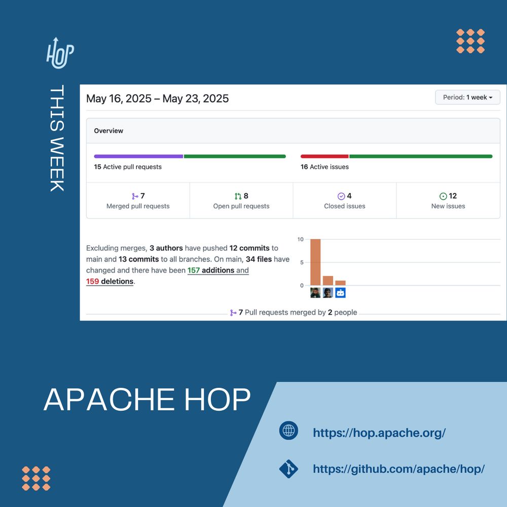
🗞️ Apache Hop Weekly – May 16–23
A week of improved UX, error handling & key upgrades!
🔧 Highlights:
🔹 Cleaner UI for file actions
🔹 Better error handling
🔹 Janino & JGit upgrades
🔹 Apache Hop 2.14.0 is out!
Thanks to all contributors! 🙌
#apachehop #datasky #databs
A week of improved UX, error handling & key upgrades!
🔧 Highlights:
🔹 Cleaner UI for file actions
🔹 Better error handling
🔹 Janino & JGit upgrades
🔹 Apache Hop 2.14.0 is out!
Thanks to all contributors! 🙌
#apachehop #datasky #databs
May 23, 2025 at 8:18 AM
🗞️ Apache Hop Weekly – May 16–23
A week of improved UX, error handling & key upgrades!
🔧 Highlights:
🔹 Cleaner UI for file actions
🔹 Better error handling
🔹 Janino & JGit upgrades
🔹 Apache Hop 2.14.0 is out!
Thanks to all contributors! 🙌
#apachehop #datasky #databs
A week of improved UX, error handling & key upgrades!
🔧 Highlights:
🔹 Cleaner UI for file actions
🔹 Better error handling
🔹 Janino & JGit upgrades
🔹 Apache Hop 2.14.0 is out!
Thanks to all contributors! 🙌
#apachehop #datasky #databs
Reposted by Stefan F. Keller

Instead of materialized views, we built in-process DuckDB caching in the control plane of Striim Developer — improving query performance 5–10x with zero added infra.
PostgreSQL for OLTP, DuckDB for Operational OLAP. But I won't call it HTAP 🤐
medium.com/striim/beyon...
PostgreSQL for OLTP, DuckDB for Operational OLAP. But I won't call it HTAP 🤐
medium.com/striim/beyon...

Beyond Materialized Views: Using DuckDB for In-Process Columnar Caching
In this post we will talk about using DuckDB as the operational analytics store for the control plane of Striim Developer — a serverless…
medium.com
April 2, 2025 at 5:47 PM
Instead of materialized views, we built in-process DuckDB caching in the control plane of Striim Developer — improving query performance 5–10x with zero added infra.
PostgreSQL for OLTP, DuckDB for Operational OLAP. But I won't call it HTAP 🤐
medium.com/striim/beyon...
PostgreSQL for OLTP, DuckDB for Operational OLAP. But I won't call it HTAP 🤐
medium.com/striim/beyon...
Reposted by Stefan F. Keller

This is actually really exciting news for the right kind of map/OSINT nerd: You can now use Overpass Turbo to query OpenStreetMap data with PostGIS SQL instead of the arcane, limited Overpass Query Language. Or use curl if you prefer. github.com/woodpeck/pos...

GitHub - woodpeck/postpass-ops: operational issues about the Postpass instance run on postpass.geofabrik.de
operational issues about the Postpass instance run on postpass.geofabrik.de - woodpeck/postpass-ops
github.com
April 11, 2025 at 7:13 PM
This is actually really exciting news for the right kind of map/OSINT nerd: You can now use Overpass Turbo to query OpenStreetMap data with PostGIS SQL instead of the arcane, limited Overpass Query Language. Or use curl if you prefer. github.com/woodpeck/pos...
Reposted by Stefan F. Keller

Many database systems claim to be compatible with PostgreSQL. But what does that really mean?
Find out in our latest blog post and learn more about what it takes to become PostgreSQL compatible.
cedardb.com/blog/postgre...
Find out in our latest blog post and learn more about what it takes to become PostgreSQL compatible.
cedardb.com/blog/postgre...

What It Takes to Be PostgreSQL Compatible
Many systems and tools, including CedarDB, claim to be “PostgreSQL compatible”, but what does that actually mean? In this article, we explain why PostgresSQL compatibility has several layers, what is ...
cedardb.com
April 24, 2025 at 9:23 PM
Many database systems claim to be compatible with PostgreSQL. But what does that really mean?
Find out in our latest blog post and learn more about what it takes to become PostgreSQL compatible.
cedardb.com/blog/postgre...
Find out in our latest blog post and learn more about what it takes to become PostgreSQL compatible.
cedardb.com/blog/postgre...
Reposted by Stefan F. Keller

Wow excellent article en JSONB www.architecture-weekly.com/p/postgresql... by @oskardudycz.bsky.social
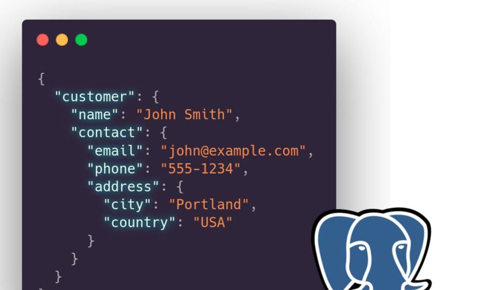
PostgreSQL JSONB - Powerful Storage for Semi-Structured Data
Object-oriented or relational? Why not both? Let's look on PostgreSQL JSONB column type and how it can help you to deliver your applications faster. We dived into how it's stored, when and why it can ...
www.architecture-weekly.com
April 21, 2025 at 6:51 PM
Wow excellent article en JSONB www.architecture-weekly.com/p/postgresql... by @oskardudycz.bsky.social
Reposted by Stefan F. Keller

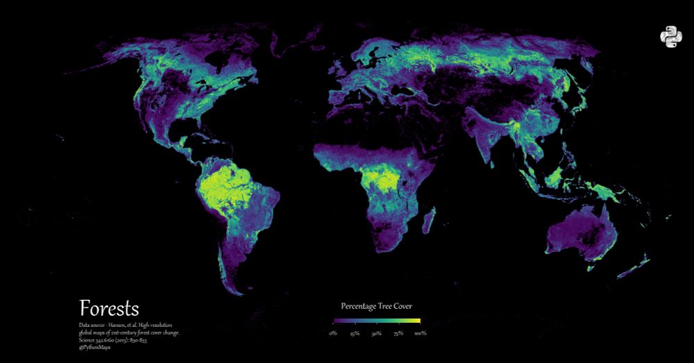
Day 14 of the #30DayMapChallenge - World Map
Here is a map of the World's forests.
Here is a map of the World's forests.
November 19, 2024 at 9:40 PM
Day 14 of the #30DayMapChallenge - World Map
Here is a map of the World's forests.
Here is a map of the World's forests.
Morgen Do. 5. Dezember 2024 referiere ich in Zürich zum Thema
"AI/ML-Driven Query #Optimization Using Balsa and LEON".
Nach dem Talk gibt es eine #AskusAnything zur Multi-Model Datenbank #PostgreSQL. Vortrag DE Folien EN. Eintritt frei.
Anmeldung: www.swisspug.org#meetup_2024-12
#Database #AI
"AI/ML-Driven Query #Optimization Using Balsa and LEON".
Nach dem Talk gibt es eine #AskusAnything zur Multi-Model Datenbank #PostgreSQL. Vortrag DE Folien EN. Eintritt frei.
Anmeldung: www.swisspug.org#meetup_2024-12
#Database #AI

December 4, 2024 at 11:08 AM
Morgen Do. 5. Dezember 2024 referiere ich in Zürich zum Thema
"AI/ML-Driven Query #Optimization Using Balsa and LEON".
Nach dem Talk gibt es eine #AskusAnything zur Multi-Model Datenbank #PostgreSQL. Vortrag DE Folien EN. Eintritt frei.
Anmeldung: www.swisspug.org#meetup_2024-12
#Database #AI
"AI/ML-Driven Query #Optimization Using Balsa and LEON".
Nach dem Talk gibt es eine #AskusAnything zur Multi-Model Datenbank #PostgreSQL. Vortrag DE Folien EN. Eintritt frei.
Anmeldung: www.swisspug.org#meetup_2024-12
#Database #AI
#OpenStreetMap inside

#30DayMapChallenge | Day 30 The Final Map | Bike Map of Madison 🚲
Been working on this map all year and still have a lot on my list to tweak, but closing out this year's series mapping Madison's great biking infrastructure. In collaboration w/ UW-Madison Geography alum Ben Cramer.
Been working on this map all year and still have a lot on my list to tweak, but closing out this year's series mapping Madison's great biking infrastructure. In collaboration w/ UW-Madison Geography alum Ben Cramer.

December 2, 2024 at 7:17 PM
#OpenStreetMap inside
Reposted by Stefan F. Keller

What better first Bluesky post than to show the latest update to Kue, our AI GIS assistant.
Kue can run geoprocessing, filter for data in layers and PostGIS databases, select features by attribute, and style your data
Read more about Kue here: buntinglabs.com/blog/kue-ai-... #gischat
Kue can run geoprocessing, filter for data in layers and PostGIS databases, select features by attribute, and style your data
Read more about Kue here: buntinglabs.com/blog/kue-ai-... #gischat

Kue AI: Assistant for QGIS User Manual (November 2024)
Kue is an AI assistant built directly into QGIS. Kue can style and label your layers, run geoprocessing, and more.
buntinglabs.com
November 30, 2024 at 12:14 AM
What better first Bluesky post than to show the latest update to Kue, our AI GIS assistant.
Kue can run geoprocessing, filter for data in layers and PostGIS databases, select features by attribute, and style your data
Read more about Kue here: buntinglabs.com/blog/kue-ai-... #gischat
Kue can run geoprocessing, filter for data in layers and PostGIS databases, select features by attribute, and style your data
Read more about Kue here: buntinglabs.com/blog/kue-ai-... #gischat