


Scribble Maps
@scribblemaps.com
For over 15 years we have helped millions easily create maps. Make maps for free at scribblemaps.com
Pinned
Scribble Maps
@scribblemaps.com
· Dec 15
Need to align edges? With our new patent-pending zipper tool, making precise boundaries and edges is now a zip!" #Innovation #GIS #Mapping
Reposted by Scribble Maps

On the migration of the scientific community to Bluesky:
www.nature.com/articles/d41... 🧪
www.nature.com/articles/d41... 🧪

Bluesky’s science takeover: 70% of Nature poll respondents use platform
Roughly 6,000 readers answered our poll, with many declaring that Bluesky was nicer, kinder and less antagonistic to science than X.
www.nature.com
January 27, 2025 at 8:19 PM
On the migration of the scientific community to Bluesky:
www.nature.com/articles/d41... 🧪
www.nature.com/articles/d41... 🧪
Discover how Scribble Maps is redefining mobile precision editing in 2025! With their patent-pending feature, create detailed drawings and edits effortlessly using just your finger – no stylus needed. Try it now at lite.scribblemaps.com. #UX #Design #GIS #Innovation #mapping
youtu.be/j7ngFiQAlNs
youtu.be/j7ngFiQAlNs

Scribble Maps Mobile Editing Breakthrough: Precision Drawing with Your Finger
YouTube video by Scribble Maps
youtu.be
January 11, 2025 at 10:11 PM
Discover how Scribble Maps is redefining mobile precision editing in 2025! With their patent-pending feature, create detailed drawings and edits effortlessly using just your finger – no stylus needed. Try it now at lite.scribblemaps.com. #UX #Design #GIS #Innovation #mapping
youtu.be/j7ngFiQAlNs
youtu.be/j7ngFiQAlNs
Reposted by Scribble Maps

Söderfjärden impact crater is the best sample of a hexagonal impact structure on Earth.
It occupies a 22 square-kilometer piece of coastal real estate in western Finland near the Gulf of Bothnia, the Baltic Sea’s northern arm 🧪
earthobservatory.nasa.gov/images/15377...
It occupies a 22 square-kilometer piece of coastal real estate in western Finland near the Gulf of Bothnia, the Baltic Sea’s northern arm 🧪
earthobservatory.nasa.gov/images/15377...

January 1, 2025 at 11:09 PM
Söderfjärden impact crater is the best sample of a hexagonal impact structure on Earth.
It occupies a 22 square-kilometer piece of coastal real estate in western Finland near the Gulf of Bothnia, the Baltic Sea’s northern arm 🧪
earthobservatory.nasa.gov/images/15377...
It occupies a 22 square-kilometer piece of coastal real estate in western Finland near the Gulf of Bothnia, the Baltic Sea’s northern arm 🧪
earthobservatory.nasa.gov/images/15377...
Santa's optimized route with charts for cookie consumption, cookie type, milk consumption, and entry method. #GIS #Christmas #Santa
www.scribblemaps.com/maps/view/Sa...
www.scribblemaps.com/maps/view/Sa...

Santa map
Santa map
www.scribblemaps.com
December 24, 2024 at 11:06 PM
Santa's optimized route with charts for cookie consumption, cookie type, milk consumption, and entry method. #GIS #Christmas #Santa
www.scribblemaps.com/maps/view/Sa...
www.scribblemaps.com/maps/view/Sa...
Reposted by Scribble Maps

Digital Earth Africa has just launched the Coastlines Monitoring Service dashboard, a world-first & uniquely tailored for the continent w/ sea level rise data for decision makers spanning the entire African coastline over the last 24 yrs.
www.africageoportal.com/apps/africag...
🧪 🦑 🌊 🌍 🌎 #GISChat
www.africageoportal.com/apps/africag...
🧪 🦑 🌊 🌍 🌎 #GISChat

December 20, 2024 at 5:05 PM
Digital Earth Africa has just launched the Coastlines Monitoring Service dashboard, a world-first & uniquely tailored for the continent w/ sea level rise data for decision makers spanning the entire African coastline over the last 24 yrs.
www.africageoportal.com/apps/africag...
🧪 🦑 🌊 🌍 🌎 #GISChat
www.africageoportal.com/apps/africag...
🧪 🦑 🌊 🌍 🌎 #GISChat
Reposted by Scribble Maps


December 21, 2024 at 7:29 PM
Reposted by Scribble Maps

This is what Tokyo's regional transit system looks like btw:

December 18, 2024 at 4:09 AM
This is what Tokyo's regional transit system looks like btw:
Need to align edges? With our new patent-pending zipper tool, making precise boundaries and edges is now a zip!" #Innovation #GIS #Mapping
December 15, 2024 at 4:25 PM
Need to align edges? With our new patent-pending zipper tool, making precise boundaries and edges is now a zip!" #Innovation #GIS #Mapping
Reposted by Scribble Maps

Great find @ividito.bsky.social
www.oldmapsonline.org/en/project , I sense many hours will now be spent browsing old maps this holiday season
www.oldmapsonline.org/en/project , I sense many hours will now be spent browsing old maps this holiday season

Project
Old maps available to everyone
www.oldmapsonline.org
December 12, 2024 at 7:44 PM
Great find @ividito.bsky.social
www.oldmapsonline.org/en/project , I sense many hours will now be spent browsing old maps this holiday season
www.oldmapsonline.org/en/project , I sense many hours will now be spent browsing old maps this holiday season
Reposted by Scribble Maps

I made this giant 3x6-foot map of the #GreatSmokyMountains to hang up in our house. Worked on it in the background over a the course of a couple of years. The last touch was dialing in the hypsometric tinting, which I think finally pulled it all together.
#smokies #nationalpark #map #cartography
#smokies #nationalpark #map #cartography


December 11, 2024 at 9:38 PM
I made this giant 3x6-foot map of the #GreatSmokyMountains to hang up in our house. Worked on it in the background over a the course of a couple of years. The last touch was dialing in the hypsometric tinting, which I think finally pulled it all together.
#smokies #nationalpark #map #cartography
#smokies #nationalpark #map #cartography
Reposted by Scribble Maps

🎉 I just wrapped up teaching the Introduction to GIS Programming course this semester at the University of Tennessee! All course materials and lecture recordings (26 hours) are freely available online.
Explore #geospatial 🌍 data visualization and analysis using #opensource Python packages:
Explore #geospatial 🌍 data visualization and analysis using #opensource Python packages:

December 7, 2024 at 2:09 PM
🎉 I just wrapped up teaching the Introduction to GIS Programming course this semester at the University of Tennessee! All course materials and lecture recordings (26 hours) are freely available online.
Explore #geospatial 🌍 data visualization and analysis using #opensource Python packages:
Explore #geospatial 🌍 data visualization and analysis using #opensource Python packages:
December 7, 2024 at 12:44 AM
Reposted by Scribble Maps

Got this working with my (still unannounced except for here) QGIS plugin. Not as fast as Overture since the files themselves aren't spatially partitioned (yet), but a big improvement from the previous release, as it's GeoParquet and works! Cool to see it on Hugging Face.
December 4, 2024 at 4:31 AM
Got this working with my (still unannounced except for here) QGIS plugin. Not as fast as Overture since the files themselves aren't spatially partitioned (yet), but a big improvement from the previous release, as it's GeoParquet and works! Cool to see it on Hugging Face.
Reposted by Scribble Maps

🕊️ The European Turtle Dove embarks on an incredible 5,000 km migration every year! 🌍🐦 Explore this and the journeys of 300+ bird species with the Bird Migration Atlas. 🌐 #BirdMigration #Conservation #Wildlife 🦅
googlemapsmania.blogspot.com/2024/12/th-b...
googlemapsmania.blogspot.com/2024/12/th-b...

The Bird Migration Atlas
Maps Mania is a blog dedicated to tracking the very best digital interactive maps on the internet and the tools used to create them.
googlemapsmania.blogspot.com
December 4, 2024 at 5:54 PM
🕊️ The European Turtle Dove embarks on an incredible 5,000 km migration every year! 🌍🐦 Explore this and the journeys of 300+ bird species with the Bird Migration Atlas. 🌐 #BirdMigration #Conservation #Wildlife 🦅
googlemapsmania.blogspot.com/2024/12/th-b...
googlemapsmania.blogspot.com/2024/12/th-b...
Reposted by Scribble Maps

i'm a dataviz designer at the @euiss.bsky.social (an EU agency dealing with foreign, security and defense policy). imet some of you at either Outlier, Info+ or 2CO in recent years.
i made this atlas of relations between the European Union and the African Union 👇
www.iss.europa.eu/content/afri...
i made this atlas of relations between the European Union and the African Union 👇
www.iss.europa.eu/content/afri...
December 3, 2024 at 10:31 AM
i'm a dataviz designer at the @euiss.bsky.social (an EU agency dealing with foreign, security and defense policy). imet some of you at either Outlier, Info+ or 2CO in recent years.
i made this atlas of relations between the European Union and the African Union 👇
www.iss.europa.eu/content/afri...
i made this atlas of relations between the European Union and the African Union 👇
www.iss.europa.eu/content/afri...
Reposted by Scribble Maps
Anybody up to test out my new QGIS plugin and confirm it works? I'm waiting for approval on plugins.qgis.org/plugins/qgis... but you can download and add as a zip from github.com/cholmes/qgis.... Enables download of the viewport of Overture, source.coop or any GeoParquet URL.
December 2, 2024 at 7:44 PM
Anybody up to test out my new QGIS plugin and confirm it works? I'm waiting for approval on plugins.qgis.org/plugins/qgis... but you can download and add as a zip from github.com/cholmes/qgis.... Enables download of the viewport of Overture, source.coop or any GeoParquet URL.
If the majority of your posts are related to GIS, or maps, reply and we will add you to our GIS/mapping starter pack.
November 30, 2024 at 4:16 PM
If the majority of your posts are related to GIS, or maps, reply and we will add you to our GIS/mapping starter pack.
Reposted by Scribble Maps
#30DayMapChallenge Day 29: Data: Overture
Hadn't used Overture before, so had fun with this challenge looking at a classic north-south divide in British culture.
A chance for some graph theory leading to a paths connecting every single Greggs and Pret in Britain.
observablehq.com/@jwolondon/t...
Hadn't used Overture before, so had fun with this challenge looking at a classic north-south divide in British culture.
A chance for some graph theory leading to a paths connecting every single Greggs and Pret in Britain.
observablehq.com/@jwolondon/t...

November 30, 2024 at 12:36 PM
#30DayMapChallenge Day 29: Data: Overture
Hadn't used Overture before, so had fun with this challenge looking at a classic north-south divide in British culture.
A chance for some graph theory leading to a paths connecting every single Greggs and Pret in Britain.
observablehq.com/@jwolondon/t...
Hadn't used Overture before, so had fun with this challenge looking at a classic north-south divide in British culture.
A chance for some graph theory leading to a paths connecting every single Greggs and Pret in Britain.
observablehq.com/@jwolondon/t...
Reposted by Scribble Maps

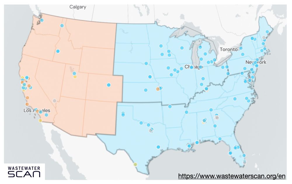
1/ Influenza wastewater activity levels are currently low across the US, aside from conspicuous areas in CA where #H5N1 is spreading in dairy cows.
A deeper dive into the Wastewater Scan data paints a very concerning picture and should add to our sense of urgency.
A deeper dive into the Wastewater Scan data paints a very concerning picture and should add to our sense of urgency.
November 26, 2024 at 10:06 PM
1/ Influenza wastewater activity levels are currently low across the US, aside from conspicuous areas in CA where #H5N1 is spreading in dairy cows.
A deeper dive into the Wastewater Scan data paints a very concerning picture and should add to our sense of urgency.
A deeper dive into the Wastewater Scan data paints a very concerning picture and should add to our sense of urgency.
Reposted by Scribble Maps


November 30, 2024 at 12:15 AM
Reposted by Scribble Maps


November 26, 2024 at 4:21 PM