


Ryan Snoddon
@ryansnoddon.bsky.social
Meteorologist for CBC in the Maritimes
Snow likely tonight/AM Friday for high terrain areas of northern NS (esp along Hwy 104) + southeast NB with localized amounts of 5-10 cm.
Improving Friday aft into Saturday. Next system set for Sunday. Details:
NS: www.youtube.com/watch?v=ArI2...
NB: www.cbc.ca/player/play/...
#nsstorm #halisky
Improving Friday aft into Saturday. Next system set for Sunday. Details:
NS: www.youtube.com/watch?v=ArI2...
NB: www.cbc.ca/player/play/...
#nsstorm #halisky


November 13, 2025 at 10:32 PM
Snow likely tonight/AM Friday for high terrain areas of northern NS (esp along Hwy 104) + southeast NB with localized amounts of 5-10 cm.
Improving Friday aft into Saturday. Next system set for Sunday. Details:
NS: www.youtube.com/watch?v=ArI2...
NB: www.cbc.ca/player/play/...
#nsstorm #halisky
Improving Friday aft into Saturday. Next system set for Sunday. Details:
NS: www.youtube.com/watch?v=ArI2...
NB: www.cbc.ca/player/play/...
#nsstorm #halisky
Reposted by Ryan Snoddon

Here's how much daylight has been lost since the summer solstice.

November 13, 2025 at 9:48 PM
Here's how much daylight has been lost since the summer solstice.
Rainfall totals for Sunday evening to Wednesday morning.
A solid shot for eastern NS!
Things remain unsettled over the next couple of days, especially in the eastern Maritimes.
Full forecast details...
Nova Scotia: www.youtube.com/watch?v=rnY8...
New Brunswick:
www.cbc.ca/player/play/...
A solid shot for eastern NS!
Things remain unsettled over the next couple of days, especially in the eastern Maritimes.
Full forecast details...
Nova Scotia: www.youtube.com/watch?v=rnY8...
New Brunswick:
www.cbc.ca/player/play/...

November 12, 2025 at 11:13 PM
Rainfall totals for Sunday evening to Wednesday morning.
A solid shot for eastern NS!
Things remain unsettled over the next couple of days, especially in the eastern Maritimes.
Full forecast details...
Nova Scotia: www.youtube.com/watch?v=rnY8...
New Brunswick:
www.cbc.ca/player/play/...
A solid shot for eastern NS!
Things remain unsettled over the next couple of days, especially in the eastern Maritimes.
Full forecast details...
Nova Scotia: www.youtube.com/watch?v=rnY8...
New Brunswick:
www.cbc.ca/player/play/...
Reposted by Ryan Snoddon

Many in New Brunswick saw a glowing spiral in the sky last night — not aliens, but the Ariane 6 rocket venting fuel high above Earth! 🌌
Tune in to Shift NB on CBC Radio One between 4:00–4:15 p.m. to hear how this stunning phenomenon lit up our skies.
#cbcradio #shiftnb #shareyourweather
Tune in to Shift NB on CBC Radio One between 4:00–4:15 p.m. to hear how this stunning phenomenon lit up our skies.
#cbcradio #shiftnb #shareyourweather


November 5, 2025 at 4:11 PM
Many in New Brunswick saw a glowing spiral in the sky last night — not aliens, but the Ariane 6 rocket venting fuel high above Earth! 🌌
Tune in to Shift NB on CBC Radio One between 4:00–4:15 p.m. to hear how this stunning phenomenon lit up our skies.
#cbcradio #shiftnb #shareyourweather
Tune in to Shift NB on CBC Radio One between 4:00–4:15 p.m. to hear how this stunning phenomenon lit up our skies.
#cbcradio #shiftnb #shareyourweather
Heavy rain + winds howling like werewolves for Halloween.
The good news is, many folks will see the heaviest rain ending BEFORE the kids head out trick or treating.
My latest forecasts...
NS: www.youtube.com/watch?v=IYxO...
NB: www.cbc.ca/player/play/...
#halisky #nsstorm #nbstorm
The good news is, many folks will see the heaviest rain ending BEFORE the kids head out trick or treating.
My latest forecasts...
NS: www.youtube.com/watch?v=IYxO...
NB: www.cbc.ca/player/play/...
#halisky #nsstorm #nbstorm


October 30, 2025 at 10:14 PM
Heavy rain + winds howling like werewolves for Halloween.
The good news is, many folks will see the heaviest rain ending BEFORE the kids head out trick or treating.
My latest forecasts...
NS: www.youtube.com/watch?v=IYxO...
NB: www.cbc.ca/player/play/...
#halisky #nsstorm #nbstorm
The good news is, many folks will see the heaviest rain ending BEFORE the kids head out trick or treating.
My latest forecasts...
NS: www.youtube.com/watch?v=IYxO...
NB: www.cbc.ca/player/play/...
#halisky #nsstorm #nbstorm
Stormy Halloween on the way with heavy rain & gusty winds.
That said... the rain will clear & the winds will ease for some parts of the Maritimes, in time for the Trick or Treaters.
My Wednesday updates.
NS: www.cbc.ca/news/canada/...
NB: www.cbc.ca/player/play/...
#nsstorm #nbstorm #halisky
That said... the rain will clear & the winds will ease for some parts of the Maritimes, in time for the Trick or Treaters.
My Wednesday updates.
NS: www.cbc.ca/news/canada/...
NB: www.cbc.ca/player/play/...
#nsstorm #nbstorm #halisky


October 29, 2025 at 9:25 PM
Stormy Halloween on the way with heavy rain & gusty winds.
That said... the rain will clear & the winds will ease for some parts of the Maritimes, in time for the Trick or Treaters.
My Wednesday updates.
NS: www.cbc.ca/news/canada/...
NB: www.cbc.ca/player/play/...
#nsstorm #nbstorm #halisky
That said... the rain will clear & the winds will ease for some parts of the Maritimes, in time for the Trick or Treaters.
My Wednesday updates.
NS: www.cbc.ca/news/canada/...
NB: www.cbc.ca/player/play/...
#nsstorm #nbstorm #halisky
Tuesday Eve Update
Quiet weather for Wednesday & Thursday.
Halloween Friday front brings gusty winds and rain - with some added moisture from Melissa (which will track to our southeast)
My latest update:
NS:
www.youtube.com/watch?v=26jy...
NB:
www.cbc.ca/player/play/...
#nswx #nbwx #halisky
Quiet weather for Wednesday & Thursday.
Halloween Friday front brings gusty winds and rain - with some added moisture from Melissa (which will track to our southeast)
My latest update:
NS:
www.youtube.com/watch?v=26jy...
NB:
www.cbc.ca/player/play/...
#nswx #nbwx #halisky

October 28, 2025 at 10:08 PM
Tuesday Eve Update
Quiet weather for Wednesday & Thursday.
Halloween Friday front brings gusty winds and rain - with some added moisture from Melissa (which will track to our southeast)
My latest update:
NS:
www.youtube.com/watch?v=26jy...
NB:
www.cbc.ca/player/play/...
#nswx #nbwx #halisky
Quiet weather for Wednesday & Thursday.
Halloween Friday front brings gusty winds and rain - with some added moisture from Melissa (which will track to our southeast)
My latest update:
NS:
www.youtube.com/watch?v=26jy...
NB:
www.cbc.ca/player/play/...
#nswx #nbwx #halisky
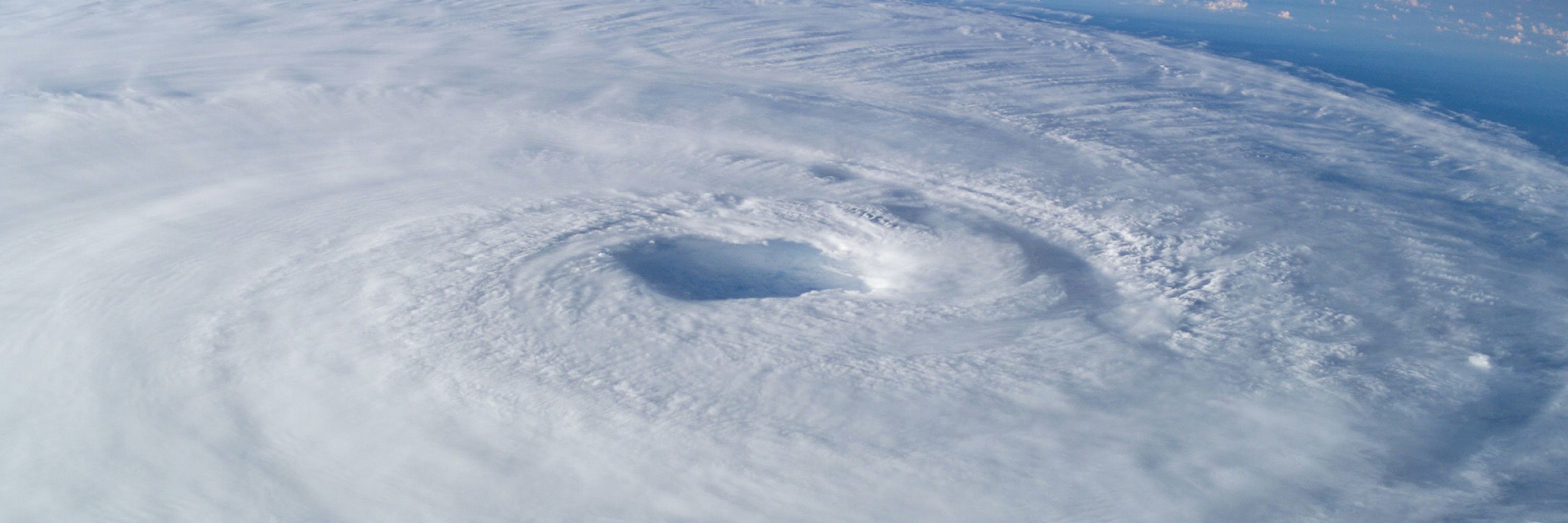
Per Jeremy, the Hurricane Hunters had to leave early, but still "captured some historic data including the 893mb center drop, cementing #Melissa as the 3rd most intense hurricane on record in the Atlantic. Mission for the ages."

I was worried for my crew mates when I saw them circling in the eye for over 20 mins. Looks like the very rough ride was confirmed. Plane had to leave early. They reported svr turb and a "sawtooth" eye. Looks like they moved 600-700ft up & down during this stretch in ~1 min.


October 28, 2025 at 9:43 PM
Per Jeremy, the Hurricane Hunters had to leave early, but still "captured some historic data including the 893mb center drop, cementing #Melissa as the 3rd most intense hurricane on record in the Atlantic. Mission for the ages."
Busy forecast this Eve.
Rain continues tonight into Tuesday morning in the Maritimes with heavy amounts locally.
Plus the latest on Hurricane Melissa and how it may 'indirectly'
impact our Halloween weather.
NS: www.youtube.com/watch?v=IvCD...
NB: www.cbc.ca/player/play/...
#nswx #nbwx #halisky
Rain continues tonight into Tuesday morning in the Maritimes with heavy amounts locally.
Plus the latest on Hurricane Melissa and how it may 'indirectly'
impact our Halloween weather.
NS: www.youtube.com/watch?v=IvCD...
NB: www.cbc.ca/player/play/...
#nswx #nbwx #halisky


October 27, 2025 at 10:15 PM
Busy forecast this Eve.
Rain continues tonight into Tuesday morning in the Maritimes with heavy amounts locally.
Plus the latest on Hurricane Melissa and how it may 'indirectly'
impact our Halloween weather.
NS: www.youtube.com/watch?v=IvCD...
NB: www.cbc.ca/player/play/...
#nswx #nbwx #halisky
Rain continues tonight into Tuesday morning in the Maritimes with heavy amounts locally.
Plus the latest on Hurricane Melissa and how it may 'indirectly'
impact our Halloween weather.
NS: www.youtube.com/watch?v=IvCD...
NB: www.cbc.ca/player/play/...
#nswx #nbwx #halisky
Reposted by Ryan Snoddon

Major Hurricane Melissa churns to the south of Jamaica.
The storm is currently a Category 5 hurricane with wind speeds of 175 mph (281 km/h).
The storm is currently a Category 5 hurricane with wind speeds of 175 mph (281 km/h).
October 27, 2025 at 6:15 PM
Major Hurricane Melissa churns to the south of Jamaica.
The storm is currently a Category 5 hurricane with wind speeds of 175 mph (281 km/h).
The storm is currently a Category 5 hurricane with wind speeds of 175 mph (281 km/h).
Rivers are running low and some wells are going dry due to the ongoing drought in the Maritimes.
Now the clock is ticking on replenishing the water table, before the ground freezes this winter. youtu.be/Dt9xxrSiQrU?...
#nswx #nbwx #halisky
Now the clock is ticking on replenishing the water table, before the ground freezes this winter. youtu.be/Dt9xxrSiQrU?...
#nswx #nbwx #halisky

Why the coming weeks are critical for the ongoing drought
YouTube video by CBC News Nova Scotia
youtu.be
October 25, 2025 at 1:30 PM
Rivers are running low and some wells are going dry due to the ongoing drought in the Maritimes.
Now the clock is ticking on replenishing the water table, before the ground freezes this winter. youtu.be/Dt9xxrSiQrU?...
#nswx #nbwx #halisky
Now the clock is ticking on replenishing the water table, before the ground freezes this winter. youtu.be/Dt9xxrSiQrU?...
#nswx #nbwx #halisky
Reposted by Ryan Snoddon

September 2025 was the third warmest on record in the Berkeley Earth dataset. But this downplays how anomalous it was; without 2023 and 2024 this year would have been well above any prior records and well above the long-term trend:

October 23, 2025 at 9:43 PM
September 2025 was the third warmest on record in the Berkeley Earth dataset. But this downplays how anomalous it was; without 2023 and 2024 this year would have been well above any prior records and well above the long-term trend:
Reposted by Ryan Snoddon

@ryansnoddon.bsky.social Beautiful colours at Spondo Lake, Lunenburg County!

October 21, 2025 at 9:22 PM
@ryansnoddon.bsky.social Beautiful colours at Spondo Lake, Lunenburg County!
Golfing this week?
We'll see not just one, but two rounds of wet weather moving through the Maritimes.
All the details...
NS: www.youtube.com/watch?v=NFJF...
NB: www.cbc.ca/player/play/...
Thanks to Trish McCormick for this picture taken at Highland Links in Ingonish, CB.
#nswx #nbwx #halisky
We'll see not just one, but two rounds of wet weather moving through the Maritimes.
All the details...
NS: www.youtube.com/watch?v=NFJF...
NB: www.cbc.ca/player/play/...
Thanks to Trish McCormick for this picture taken at Highland Links in Ingonish, CB.
#nswx #nbwx #halisky

October 20, 2025 at 9:33 PM
Golfing this week?
We'll see not just one, but two rounds of wet weather moving through the Maritimes.
All the details...
NS: www.youtube.com/watch?v=NFJF...
NB: www.cbc.ca/player/play/...
Thanks to Trish McCormick for this picture taken at Highland Links in Ingonish, CB.
#nswx #nbwx #halisky
We'll see not just one, but two rounds of wet weather moving through the Maritimes.
All the details...
NS: www.youtube.com/watch?v=NFJF...
NB: www.cbc.ca/player/play/...
Thanks to Trish McCormick for this picture taken at Highland Links in Ingonish, CB.
#nswx #nbwx #halisky
Seasonal mid-October temps this weekend, with a chance of lingering showers for eastern areas of the Maritimes & a bit more sun in the mix for western areas.
Full forecast details...
NS: www.youtube.com/watch?v=mV6U...
NB: www.cbc.ca/player/play/...
📷 Neila MacLellan in Iona, CB
#nswx #nbwx
Full forecast details...
NS: www.youtube.com/watch?v=mV6U...
NB: www.cbc.ca/player/play/...
📷 Neila MacLellan in Iona, CB
#nswx #nbwx

October 17, 2025 at 10:14 PM
Seasonal mid-October temps this weekend, with a chance of lingering showers for eastern areas of the Maritimes & a bit more sun in the mix for western areas.
Full forecast details...
NS: www.youtube.com/watch?v=mV6U...
NB: www.cbc.ca/player/play/...
📷 Neila MacLellan in Iona, CB
#nswx #nbwx
Full forecast details...
NS: www.youtube.com/watch?v=mV6U...
NB: www.cbc.ca/player/play/...
📷 Neila MacLellan in Iona, CB
#nswx #nbwx

One of the warmest October days on record in the Maritimes.
New October provincial record set in PEI, where Stanhope hit 28.7° & tied in NB, where Kouchibouguac hit 31.1°.
A few official stations just shy of 31.1° Oct record for NS, however some unofficial spots did exceed that mark!
#nswx #nbwx
New October provincial record set in PEI, where Stanhope hit 28.7° & tied in NB, where Kouchibouguac hit 31.1°.
A few official stations just shy of 31.1° Oct record for NS, however some unofficial spots did exceed that mark!
#nswx #nbwx


October 6, 2025 at 9:38 PM
September recap via ECCC's Climate Atlantic.
Ongoing drought conditions continue to be the headline.
Most of the region was far drier than average, however the most extreme conditions were experienced across northern Nova Scotia with just 10 to 30 mm of rainfall.
#nswx #nbwx #halisky
Ongoing drought conditions continue to be the headline.
Most of the region was far drier than average, however the most extreme conditions were experienced across northern Nova Scotia with just 10 to 30 mm of rainfall.
#nswx #nbwx #halisky


October 3, 2025 at 9:47 PM
Signs of the ongoing drought are everywhere...
This is McMaster Mill Falls (also known as Rockville Notch Falls), located on South Mountain, just outside of Greenwood, Nova Scotia.
The picture on the left was taken a few days ago. Picture on the right was taken early Oct 2024.
📷 Julie Mann
This is McMaster Mill Falls (also known as Rockville Notch Falls), located on South Mountain, just outside of Greenwood, Nova Scotia.
The picture on the left was taken a few days ago. Picture on the right was taken early Oct 2024.
📷 Julie Mann


October 2, 2025 at 9:09 PM
Signs of the ongoing drought are everywhere...
This is McMaster Mill Falls (also known as Rockville Notch Falls), located on South Mountain, just outside of Greenwood, Nova Scotia.
The picture on the left was taken a few days ago. Picture on the right was taken early Oct 2024.
📷 Julie Mann
This is McMaster Mill Falls (also known as Rockville Notch Falls), located on South Mountain, just outside of Greenwood, Nova Scotia.
The picture on the left was taken a few days ago. Picture on the right was taken early Oct 2024.
📷 Julie Mann
Reposted by Ryan Snoddon

Published today: our new paper showing a 44-year trend of increasing global wildfire disasters (fatalities and economic losses) due to climate change-induced extreme weather. www.science.org/doi/10.1126/...
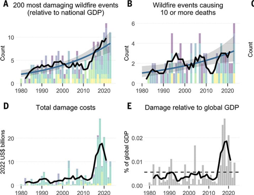
Climate-linked escalation of societally disastrous wildfires
Climate change and land mismanagement are creating increasingly fire-prone built and natural environments. However, despite worsening fire seasons, evidence is lacking globally for trends in socially ...
www.science.org
October 2, 2025 at 6:28 PM
Published today: our new paper showing a 44-year trend of increasing global wildfire disasters (fatalities and economic losses) due to climate change-induced extreme weather. www.science.org/doi/10.1126/...
Incoming cold front will shift our winds to north & usher in a fall feel over the next few days.
Apart from a few showers behind the front on Tuesday & Wednesday, it's high pressure that will dominate for the next week.
Meanwhile, Humberto and Imelda track well offshore.
#nsstorm #nbstorm #halisky
Apart from a few showers behind the front on Tuesday & Wednesday, it's high pressure that will dominate for the next week.
Meanwhile, Humberto and Imelda track well offshore.
#nsstorm #nbstorm #halisky


September 29, 2025 at 10:23 PM
Reposted by Ryan Snoddon

17:26: Due to dry and windy conditions, the wildfire at Lake George has returned to an out-of-control status. The current estimated size is 80 hectares.


September 29, 2025 at 8:46 PM
17:26: Due to dry and windy conditions, the wildfire at Lake George has returned to an out-of-control status. The current estimated size is 80 hectares.
Lake George wildfire has reverted back to out of control due to windy and dry conditions.
Visible satellite from Monday afternoon clearly shows smoke from the Lake George wildfire.
Winds will shift to northerly and remain breezy for Tuesday. Gusty north winds on tap again Wednesday.
#nswx #halisky
Visible satellite from Monday afternoon clearly shows smoke from the Lake George wildfire.
Winds will shift to northerly and remain breezy for Tuesday. Gusty north winds on tap again Wednesday.
#nswx #halisky

September 29, 2025 at 9:48 PM
Rain tonight into Friday with rainfall in the 10 to 30 mm range, highest amounts for NB.
Southerly winds gusting 40-60+ km/h tonight into AM Friday, with Les Suetes near 100 km/h.
Quiet weekend & early next week.
Watching Humberto & possibly Imelda over the next few days.
#nsstorm #nbstorm #halisky
Southerly winds gusting 40-60+ km/h tonight into AM Friday, with Les Suetes near 100 km/h.
Quiet weekend & early next week.
Watching Humberto & possibly Imelda over the next few days.
#nsstorm #nbstorm #halisky


September 25, 2025 at 9:43 PM
As Fall officially begins, here's a look back at the past 90 days of summer and the drought conditions across the Maritimes.
Most of the region saw a rainfall deficit near 100 to 150 mm, with the Bay of Fundy region departure from average in the 150-200+ mm range.
#nswx #nbwx #halisky
Most of the region saw a rainfall deficit near 100 to 150 mm, with the Bay of Fundy region departure from average in the 150-200+ mm range.
#nswx #nbwx #halisky

September 23, 2025 at 9:47 PM