


Jakub Nowosad
@nowosad.fosstodon.org.ap.brid.gy
Computational geographer. Associate Professor at AMU, Poznan, Poland. Co-author of http://r.geocompx.org, http://py.geocompx.org, and http://r-tmap.github.io […]
[bridged from https://fosstodon.org/@nowosad on the fediverse by https://fed.brid.gy/ ]
[bridged from https://fosstodon.org/@nowosad on the fediverse by https://fed.brid.gy/ ]
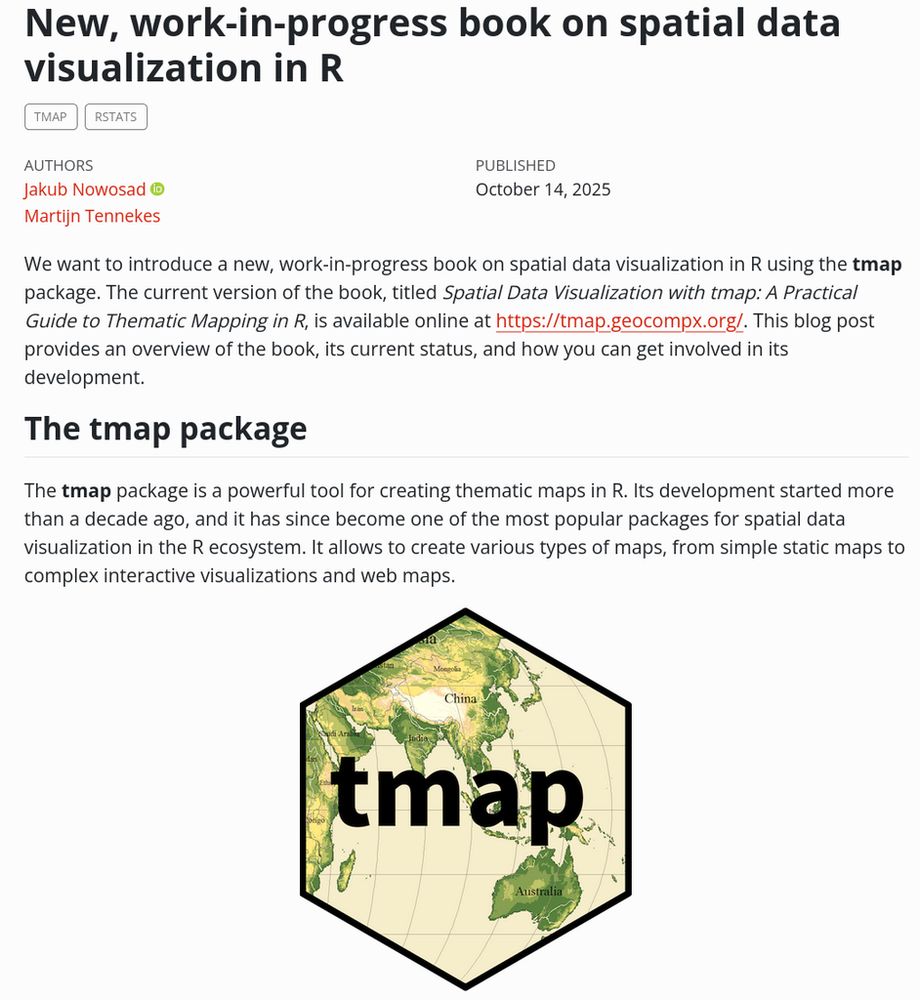
What a delight to read this book/project 😃 😃 https://tmap.geocompx.org/ #rstats #gis #gischat Many thanks to @nowosad and Martijn Tennekes for putting it together. Tmap is my very favorite R library for creating maps ❤️
Spatial Data Visualization with tmap
“Spatial Data Visualization with tmap: A Practical Guide to Thematic Mapping in R” is a free, open-source book that teaches you how to create static and interactive maps using the tmap package in R. Covering core concepts in thematic cartography, map design, and spatial visualization, this guide provides step-by-step approaches to help you produce high-quality maps for reports, presentations, and web applications.
tmap.geocompx.org
November 14, 2025 at 4:26 PM
Reposted by Jakub Nowosad

What a delight to read this book/project 😃 😃 https://tmap.geocompx.org/ #rstats #gis #gischat Many thanks to @nowosad and Martijn Tennekes for putting it together. Tmap is my very favorite R library for creating maps ❤️
Spatial Data Visualization with tmap
“Spatial Data Visualization with tmap: A Practical Guide to Thematic Mapping in R” is a free, open-source book that teaches you how to create static and interactive maps using the tmap package in R. Covering core concepts in thematic cartography, map design, and spatial visualization, this guide provides step-by-step approaches to help you produce high-quality maps for reports, presentations, and web applications.
tmap.geocompx.org
November 13, 2025 at 4:12 PM
What a delight to read this book/project 😃 😃 https://tmap.geocompx.org/ #rstats #gis #gischat Many thanks to @nowosad and Martijn Tennekes for putting it together. Tmap is my very favorite R library for creating maps ❤️
tmap or ggplot2 for maps? 🗺️
David O’Sullivan breaks down the trade-offs in a blog post.
URL: https://dosull.github.io/posts/2024-11-16-tmap-vs-ggplot/tmap4-vs-ggplot2.html
#rstats #rspatial #maps #tmap #ggplot2
David O’Sullivan breaks down the trade-offs in a blog post.
URL: https://dosull.github.io/posts/2024-11-16-tmap-vs-ggplot/tmap4-vs-ggplot2.html
#rstats #rspatial #maps #tmap #ggplot2
tmap vs. ggplot2 for mapping – Geospatial Stuff
For me at least the choice between ggplot2 and tmap is an ongoing question. Here are my latest thoughts on the subject (with code).
dosull.github.io
November 12, 2025 at 2:02 PM
Confused about coordinate reference systems (CRSs)? 🧭🌍🐍
Chapter 6 of Geocomputation with Python dives into:
- Geographic vs projected CRSs (lon/lat vs meters)
- Getting, setting & reprojecting CRSs
- Why ignoring CRSs can break your analysis 🚨
👉 […]
[Original post on fosstodon.org]
Chapter 6 of Geocomputation with Python dives into:
- Geographic vs projected CRSs (lon/lat vs meters)
- Getting, setting & reprojecting CRSs
- Why ignoring CRSs can break your analysis 🚨
👉 […]
[Original post on fosstodon.org]
November 9, 2025 at 2:02 PM
Confused about coordinate reference systems (CRSs)? 🧭🌍🐍
Chapter 6 of Geocomputation with Python dives into:
- Geographic vs projected CRSs (lon/lat vs meters)
- Getting, setting & reprojecting CRSs
- Why ignoring CRSs can break your analysis 🚨
👉 […]
[Original post on fosstodon.org]
Chapter 6 of Geocomputation with Python dives into:
- Geographic vs projected CRSs (lon/lat vs meters)
- Getting, setting & reprojecting CRSs
- Why ignoring CRSs can break your analysis 🚨
👉 […]
[Original post on fosstodon.org]
Reposted by Jakub Nowosad

Next year's edition of the European Geosciences Union General Assembly (EGU26) in Vienna has a new session, dedicated to high-performance computation in the geosciences.
This session is for people working on software to solve larger problems and solve problems faster. It is fine for presenters […]
This session is for people working on software to solve larger problems and solve problems faster. It is fine for presenters […]
Original post on social.edu.nl
social.edu.nl
November 6, 2025 at 5:20 PM
Next year's edition of the European Geosciences Union General Assembly (EGU26) in Vienna has a new session, dedicated to high-performance computation in the geosciences.
This session is for people working on software to solve larger problems and solve problems faster. It is fine for presenters […]
This session is for people working on software to solve larger problems and solve problems faster. It is fine for presenters […]
The CRAN Spatial Task View just got a proper table of contents (thanks to Krzysztof Dyba) -- easier to navigate all those R spatial packages now. 🌍
> https://cran.r-project.org/view=Spatial
#rstats #rspatial #opensource #gischat
> https://cran.r-project.org/view=Spatial
#rstats #rspatial #opensource #gischat


November 5, 2025 at 2:02 PM
The CRAN Spatial Task View just got a proper table of contents (thanks to Krzysztof Dyba) -- easier to navigate all those R spatial packages now. 🌍
> https://cran.r-project.org/view=Spatial
#rstats #rspatial #opensource #gischat
> https://cran.r-project.org/view=Spatial
#rstats #rspatial #opensource #gischat
Working with raster + vector together in Python? 🗺️🌍🐍
Chapter 5 of geocompx talks about:
- Cropping & masking rasters with vectors
- Extracting raster values via vector data
- Raster ↔️ vector conversion (polygonize & rasterize)
👉 https://py.geocompx.org/05-raster-vector
#geopython #python […]
Chapter 5 of geocompx talks about:
- Cropping & masking rasters with vectors
- Extracting raster values via vector data
- Raster ↔️ vector conversion (polygonize & rasterize)
👉 https://py.geocompx.org/05-raster-vector
#geopython #python […]
Original post on fosstodon.org
fosstodon.org
November 2, 2025 at 2:00 PM
Working with raster + vector together in Python? 🗺️🌍🐍
Chapter 5 of geocompx talks about:
- Cropping & masking rasters with vectors
- Extracting raster values via vector data
- Raster ↔️ vector conversion (polygonize & rasterize)
👉 https://py.geocompx.org/05-raster-vector
#geopython #python […]
Chapter 5 of geocompx talks about:
- Cropping & masking rasters with vectors
- Extracting raster values via vector data
- Raster ↔️ vector conversion (polygonize & rasterize)
👉 https://py.geocompx.org/05-raster-vector
#geopython #python […]
Reposted by Jakub Nowosad

The #agit2026 call for papers is out:
Short paper submission deadline: March 1, 2026
https://agit.at/en/submissions/
#gischat #giscience #cfp #agit #salzburg
Short paper submission deadline: March 1, 2026
https://agit.at/en/submissions/
#gischat #giscience #cfp #agit #salzburg

AGIT Submissions
agit.at
October 31, 2025 at 9:30 PM
The #agit2026 call for papers is out:
Short paper submission deadline: March 1, 2026
https://agit.at/en/submissions/
#gischat #giscience #cfp #agit #salzburg
Short paper submission deadline: March 1, 2026
https://agit.at/en/submissions/
#gischat #giscience #cfp #agit #salzburg
#30DayMapChallenge starts tomorrow: 30 days, 30 map ideas.
If you’re using R, Python, or Julia, consider sharing open-source examples or tutorials. 🧭
https://30daymapchallenge.com/
#geodata #dataviz #maps #spatialviz
If you’re using R, Python, or Julia, consider sharing open-source examples or tutorials. 🧭
https://30daymapchallenge.com/
#geodata #dataviz #maps #spatialviz

30DayMapChallenge
Daily mapping challenge happening every November!
30daymapchallenge.com
October 31, 2025 at 3:03 PM
#30DayMapChallenge starts tomorrow: 30 days, 30 map ideas.
If you’re using R, Python, or Julia, consider sharing open-source examples or tutorials. 🧭
https://30daymapchallenge.com/
#geodata #dataviz #maps #spatialviz
If you’re using R, Python, or Julia, consider sharing open-source examples or tutorials. 🧭
https://30daymapchallenge.com/
#geodata #dataviz #maps #spatialviz
Reposted by Jakub Nowosad

Just as I've started to get a pretty comfortable with all the coordinate representations, projections, etc., I see this. If I would've came across an older dataset with this before now, I'm not sure what I would've done. Tried an internet search out of […]
[Original post on fosstodon.org]
[Original post on fosstodon.org]

October 30, 2025 at 8:52 PM
Just as I've started to get a pretty comfortable with all the coordinate representations, projections, etc., I see this. If I would've came across an older dataset with this before now, I'm not sure what I would've done. Tried an internet search out of […]
[Original post on fosstodon.org]
[Original post on fosstodon.org]
Interested in teaching spatial data skills for urbanism? 🗺️
The Geospatial Data Carpentry for Urbanism (TU Delft / thecarpentries) seeks beta pilot workshops.
Details 👉 https://carpentries.org/blog/2025/10/geospatial-data-carpentry-for-urbanism/
#rstats #gis #carpentries #rspatial
The Geospatial Data Carpentry for Urbanism (TU Delft / thecarpentries) seeks beta pilot workshops.
Details 👉 https://carpentries.org/blog/2025/10/geospatial-data-carpentry-for-urbanism/
#rstats #gis #carpentries #rspatial

Calling for Beta Pilot Workshops: Geospatial Data Carpentry for Urbanism
Researchers from the Department of Urbanism and members of the Digital Competence Centre at TU Delft have worked since 2023 on the curriculum Geospatial Data Carpentry for Urbanism, currently in The Carpentries Incubator. This curriculum, inspired by the pre-existing Geospatial Data Carpentry, part of The Carpentries, was designed to introduce learners from the domain of urbanism to the use of R programming when analysing and visualising vector and raster data. It also introduces basic GIS operations using R. These skills are particularly relevant when working in the field of urbanism, but can be applied to other urbanism-related ones.
carpentries.org
October 29, 2025 at 2:02 PM
Interested in teaching spatial data skills for urbanism? 🗺️
The Geospatial Data Carpentry for Urbanism (TU Delft / thecarpentries) seeks beta pilot workshops.
Details 👉 https://carpentries.org/blog/2025/10/geospatial-data-carpentry-for-urbanism/
#rstats #gis #carpentries #rspatial
The Geospatial Data Carpentry for Urbanism (TU Delft / thecarpentries) seeks beta pilot workshops.
Details 👉 https://carpentries.org/blog/2025/10/geospatial-data-carpentry-for-urbanism/
#rstats #gis #carpentries #rspatial
Reposted by Jakub Nowosad

Hey peeps! We've had a fab summer off, and are now getting back into it. Our dates for the season are:
20 November
22 January
19 February
12 March
23 April
21 May
If you'd like to speak, please get in touch!
#rstats #datascience #edinburgh #scotland
20 November
22 January
19 February
12 March
23 April
21 May
If you'd like to speak, please get in touch!
#rstats #datascience #edinburgh #scotland
October 27, 2025 at 3:33 PM
Hey peeps! We've had a fab summer off, and are now getting back into it. Our dates for the season are:
20 November
22 January
19 February
12 March
23 April
21 May
If you'd like to speak, please get in touch!
#rstats #datascience #edinburgh #scotland
20 November
22 January
19 February
12 March
23 April
21 May
If you'd like to speak, please get in touch!
#rstats #datascience #edinburgh #scotland
Want to transform the geometry of spatial data in Python? ✨🌍🐍
Chapter 4 of geocompy covers:
- Vector: simplify, buffer, centroid, clip, unions, affine transforms
- Raster: crop, resample, aggregate, align datasets
👉 https://py.geocompx.org/04-geometry-operations
#geopython #python #gischat […]
Chapter 4 of geocompy covers:
- Vector: simplify, buffer, centroid, clip, unions, affine transforms
- Raster: crop, resample, aggregate, align datasets
👉 https://py.geocompx.org/04-geometry-operations
#geopython #python #gischat […]
Original post on fosstodon.org
fosstodon.org
October 26, 2025 at 2:02 PM
Want to transform the geometry of spatial data in Python? ✨🌍🐍
Chapter 4 of geocompy covers:
- Vector: simplify, buffer, centroid, clip, unions, affine transforms
- Raster: crop, resample, aggregate, align datasets
👉 https://py.geocompx.org/04-geometry-operations
#geopython #python #gischat […]
Chapter 4 of geocompy covers:
- Vector: simplify, buffer, centroid, clip, unions, affine transforms
- Raster: crop, resample, aggregate, align datasets
👉 https://py.geocompx.org/04-geometry-operations
#geopython #python #gischat […]
🌍 Blog series: Spatial Machine Learning with R
From caret to tidymodels, mlr3, and specialized spatial ML packages — explore how spatial context changes the way we build ML models in R.
Start with Part 1 👉 https://geocompx.org/post/2025/sml-bp1/
#rstats #spatialml #machinelearning #rspatial
From caret to tidymodels, mlr3, and specialized spatial ML packages — explore how spatial context changes the way we build ML models in R.
Start with Part 1 👉 https://geocompx.org/post/2025/sml-bp1/
#rstats #spatialml #machinelearning #rspatial


October 22, 2025 at 1:02 PM
🌍 Blog series: Spatial Machine Learning with R
From caret to tidymodels, mlr3, and specialized spatial ML packages — explore how spatial context changes the way we build ML models in R.
Start with Part 1 👉 https://geocompx.org/post/2025/sml-bp1/
#rstats #spatialml #machinelearning #rspatial
From caret to tidymodels, mlr3, and specialized spatial ML packages — explore how spatial context changes the way we build ML models in R.
Start with Part 1 👉 https://geocompx.org/post/2025/sml-bp1/
#rstats #spatialml #machinelearning #rspatial

Spatial operations in Python? 📍🌍🐍
Chapter 3 of Geocomputation with Python covers:
- Vector: spatial joins, subsetting, aggregation, etc.
- Raster: map algebra (local, focal, zonal, global), tiling & merging
👉 https://py.geocompx.org/03-spatial-operations
#geopython #python #gischat #geocompx
Chapter 3 of Geocomputation with Python covers:
- Vector: spatial joins, subsetting, aggregation, etc.
- Raster: map algebra (local, focal, zonal, global), tiling & merging
👉 https://py.geocompx.org/03-spatial-operations
#geopython #python #gischat #geocompx
3 Spatial data operations – Geocomputation with Python
An introductory resource for working with geographic data in Python
py.geocompx.org
October 19, 2025 at 3:48 PM
Spatial operations in Python? 📍🌍🐍
Chapter 3 of Geocomputation with Python covers:
- Vector: spatial joins, subsetting, aggregation, etc.
- Raster: map algebra (local, focal, zonal, global), tiling & merging
👉 https://py.geocompx.org/03-spatial-operations
#geopython #python #gischat #geocompx
Chapter 3 of Geocomputation with Python covers:
- Vector: spatial joins, subsetting, aggregation, etc.
- Raster: map algebra (local, focal, zonal, global), tiling & merging
👉 https://py.geocompx.org/03-spatial-operations
#geopython #python #gischat #geocompx
New R package: gridmappr by Roger Beecham
It automates creating small multiple gridmap layouts by optimally placing geographic points into grid cells (inspired by Jo Wood’s Observable notebooks).
👉 https://github.com/rogerbeecham/gridmappr
#rstats #rspatial #dataviz #gischat
It automates creating small multiple gridmap layouts by optimally placing geographic points into grid cells (inspired by Jo Wood’s Observable notebooks).
👉 https://github.com/rogerbeecham/gridmappr
#rstats #rspatial #dataviz #gischat

October 15, 2025 at 1:02 PM
New R package: gridmappr by Roger Beecham
It automates creating small multiple gridmap layouts by optimally placing geographic points into grid cells (inspired by Jo Wood’s Observable notebooks).
👉 https://github.com/rogerbeecham/gridmappr
#rstats #rspatial #dataviz #gischat
It automates creating small multiple gridmap layouts by optimally placing geographic points into grid cells (inspired by Jo Wood’s Observable notebooks).
👉 https://github.com/rogerbeecham/gridmappr
#rstats #rspatial #dataviz #gischat
Reposted by Jakub Nowosad

Working with geospatial attribute data in Python? 📊🌍🐍
Chapter 2 of Geocomputation with Python covers subsetting, aggregation & joins for vector data, and subsetting + summarizing raster values.
👉 https://py.geocompx.org/02-attribute-operations
#geopython #python #gischat
Chapter 2 of Geocomputation with Python covers subsetting, aggregation & joins for vector data, and subsetting + summarizing raster values.
👉 https://py.geocompx.org/02-attribute-operations
#geopython #python #gischat


October 12, 2025 at 1:02 PM
Working with geospatial attribute data in Python? 📊🌍🐍
Chapter 2 of Geocomputation with Python covers subsetting, aggregation & joins for vector data, and subsetting + summarizing raster values.
👉 https://py.geocompx.org/02-attribute-operations
#geopython #python #gischat
Chapter 2 of Geocomputation with Python covers subsetting, aggregation & joins for vector data, and subsetting + summarizing raster values.
👉 https://py.geocompx.org/02-attribute-operations
#geopython #python #gischat
New blog post by Adam Steer: Identifying deformed sea ice using geomorphons ❄️🌊
Exploring sea ice as a landscape analysis problem with QGIS + GRASS GIS, using drone + lidar data.
👉 https://www.spatialised.net/identifying-deformed-sea-ice-using-geomorphons/
#geospatial #rstats #rspatial #gischat
Exploring sea ice as a landscape analysis problem with QGIS + GRASS GIS, using drone + lidar data.
👉 https://www.spatialised.net/identifying-deformed-sea-ice-using-geomorphons/
#geospatial #rstats #rspatial #gischat


October 8, 2025 at 1:02 PM
New blog post by Adam Steer: Identifying deformed sea ice using geomorphons ❄️🌊
Exploring sea ice as a landscape analysis problem with QGIS + GRASS GIS, using drone + lidar data.
👉 https://www.spatialised.net/identifying-deformed-sea-ice-using-geomorphons/
#geospatial #rstats #rspatial #gischat
Exploring sea ice as a landscape analysis problem with QGIS + GRASS GIS, using drone + lidar data.
👉 https://www.spatialised.net/identifying-deformed-sea-ice-using-geomorphons/
#geospatial #rstats #rspatial #gischat
Starting out with geographic data in Python? 🌍🐍
Chapter 1 of Geocomputation with Python introduces vector & raster models + core tools (geopandas, shapely, rasterio).
👉 https://py.geocompx.org/01-spatial-data
#geopython #python #gischat
Chapter 1 of Geocomputation with Python introduces vector & raster models + core tools (geopandas, shapely, rasterio).
👉 https://py.geocompx.org/01-spatial-data
#geopython #python #gischat


October 5, 2025 at 1:01 PM
Starting out with geographic data in Python? 🌍🐍
Chapter 1 of Geocomputation with Python introduces vector & raster models + core tools (geopandas, shapely, rasterio).
👉 https://py.geocompx.org/01-spatial-data
#geopython #python #gischat
Chapter 1 of Geocomputation with Python introduces vector & raster models + core tools (geopandas, shapely, rasterio).
👉 https://py.geocompx.org/01-spatial-data
#geopython #python #gischat
New post by David O’Sullivan:
“Raster really is faster (and vaster), but vector just seems more corrector.”
Part 1A of a series revisiting ideas from Geographic Information Analysis: fractals, raster vs vector, and R code.
👉 […]
[Original post on fosstodon.org]
“Raster really is faster (and vaster), but vector just seems more corrector.”
Part 1A of a series revisiting ideas from Geographic Information Analysis: fractals, raster vs vector, and R code.
👉 […]
[Original post on fosstodon.org]


October 1, 2025 at 1:01 PM
New post by David O’Sullivan:
“Raster really is faster (and vaster), but vector just seems more corrector.”
Part 1A of a series revisiting ideas from Geographic Information Analysis: fractals, raster vs vector, and R code.
👉 […]
[Original post on fosstodon.org]
“Raster really is faster (and vaster), but vector just seems more corrector.”
Part 1A of a series revisiting ideas from Geographic Information Analysis: fractals, raster vs vector, and R code.
👉 […]
[Original post on fosstodon.org]
Reposted by Jakub Nowosad

🎥 I've published a video based on my #geomobNL talk in Eindhoven on 18 Sept on #digitalsovereignty & #opensource for geo, covering procurement, policy, and community-driven development.
Watch here: youtu.be/0u6tPM-USHY
💬 Feel free to share your comments.
Watch here: youtu.be/0u6tPM-USHY
💬 Feel free to share your comments.

Digital Sovereignty and Open Source Software for Geo
YouTube video by Hans van der Kwast
youtu.be
September 28, 2025 at 8:28 AM
🎥 I've published a video based on my #geomobNL talk in Eindhoven on 18 Sept on #digitalsovereignty & #opensource for geo, covering procurement, policy, and community-driven development.
Watch here: youtu.be/0u6tPM-USHY
💬 Feel free to share your comments.
Watch here: youtu.be/0u6tPM-USHY
💬 Feel free to share your comments.
Reposted by Jakub Nowosad

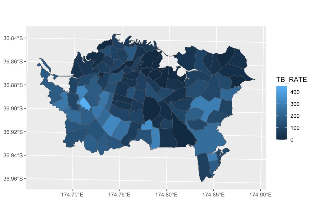
hivemind style question about spatial model sampling strategy: when modelling a highly spatially autocorrelated response such as the one shown here, I found the only way to produce models with correctable spatial autocorrelation (using eigenvectors) in the […]
[Original post on sciences.social]
[Original post on sciences.social]

September 26, 2025 at 1:31 PM
hivemind style question about spatial model sampling strategy: when modelling a highly spatially autocorrelated response such as the one shown here, I found the only way to produce models with correctable spatial autocorrelation (using eigenvectors) in the […]
[Original post on sciences.social]
[Original post on sciences.social]